Download presentation
Presentation is loading. Please wait.

1
Copyright 2008 Coast Guard Auxiliary Association, Inc. The Weekend Navigator Basic Level I

2
Chapter 4: The Tools of Navigation

3
Chapter 4: Lesson Objectives Charts and their construction Mercator projection versus a polyconic projection Pros and cons of Mercator projections Pros and cons of polyconic projections Reading a chart

4
Chapter 4: Lesson Objectives Navigational tools Using navigational tools Using other navigational tools Lesson experience using plotting exercises

5
What are the Tools of the Trade? Charts Aids to navigation Plotting tools Compasses Electronic navigation instruments

6
What is a Nautical Chart? Provides information what is on and under the water Scaled representation of the earth, accurately portraying shapes, distances, and directions Charts are made to be drawn on!

7
Who Prepares Nautical Charts? Information is provided by the National Oceanographic and Atmospheric Administration (NOAA) Charts are prepared by the National Ocean Service (NOS)
 Charts are prepared by the National Ocean Service (NOS).")
8
How to Project the Earth on a Flat Chart? Done by using projections for specific applications Two types of maps: –Mercator projections –Polyconic projections

9
Mercator Projection? Parallels of latitude are horizontal and straight Meridians of longitude are vertical and straight Parallels intersect the meridians at right angles

10
Advantages of a Mercator Projection You can measure and plot directions and distance directly on the chart and use them for navigation Maintains directional relationships better over long distances Projection of choice for coastal and offshore navigation

11
Disadvantages of a Mercator Projection Distorts the shapes and relative sizes of landmasses and ocean basins –Land masses will appear larger than they actually are Distortion becomes exaggerated near the poles

12
Polyconic Projection Developed from a series of cones placed over the earth’s surface and then flattened In local areas, the parallels are perpendicular with the meridian Courses can be plotted

13
Polyconic Projection

15
Advantages of a Polyconic Projection Used for inland and lake nautical charts –Great Lakes and major river systems

16
Disadvantages of a Polyconic Projection Not suitable for plotting travel over great distances

17
What Information is Found on a Chart? Depths Scales Updates Coordinates Symbols Chart grid Horizontal datum

18
Soundings are plotted depth measurements either in feet or fathoms Vertical datum or standard is established because of fluctuating water levels in tidal regions –Mean low water (MLW) –Mean lower low water (MLLW) Depths
 –Mean lower low water (MLLW) Depths")
19
Depth contour lines are used to identify points of selected constant depth –Plotted in multiples of fathoms (6 feet) –Contour depths are oriented with the contour and is in contrasting print (italic vs. regular)
.")
20
Depths Shallow water is colored light blue Deep water is colored white Very shallow water is colored green Land is colored tan

21
Scales Charts come in variety of scales –1:40,000-scale means 1 inch on the chart equals 40,000 inches (1/2 nautical mile) Local waters: 1:20,000 scale Harbors: 1:10,000 scale Open waters: 1:80,000 scale
 Local waters: 1:20,000 scale Harbors: 1:10,000 scale Open waters: 1:80,000 scale")
22
Scales The smaller the ratio, the larger the scale and the more detail (i.e. 1:10,000) –Good for navigation in narrow and rock-strewn waters The larger the ratio the smaller the scale and the less detail (i.e. 1:80,000) –Good for “big picture” cruise planning
 –Good for navigation in narrow and rock-strewn waters The larger the ratio the smaller the scale and the less detail (i.e. 1:80,000) –Good for big picture cruise planning.")
23
Updates Updated only at intervals Updates provided by hydrographic via Notice to Mariners (NTM) Updates provided by the USCG via Local Notice to Mariners (LNM)
 Updates provided by the USCG via Local Notice to Mariners (LNM)")
24
Chart Grid and Horizontal Datum Utilizes a system of coordinates of latitude and longitude Horizontal datum is a framework that allows for a common reference World Geodetic System 1984 (WGS-84) is used today as the horizontal datum
 is used today as the horizontal datum")
25
Coordinates Latitude and longitude provide a nautical position address Latitude scale is found on the left and right margins of the chart Longitude scale is found on the top and bottom margins

26
Coordinates Meridians are lines of longitude or vertical slices that pass through both poles Prime Meridian is at 0 o and passes through Greenwich, England All meridians are great circles

27
What is a Great Circle? An imaginary line scribed on the Earth’s surface by a plane passing through the exact center of the Earth

28
Rhumb Line Rhumb line is a course on a single bearing

29
Finding Your Spot on the Earth Scales on coastal nautical charts are divided into: –Degrees –Minutes –Tenths of minutes A minute of angle is 1/60 th of a degree

30
A minute of latitude is always exactly equal to one nautical mile The latitude scale can be used for measuring distance on the a chart A minute of longitude is equal to one nautical mile only at the equator, but can not be used for measuring distance on a chart Finding Your Spot on the Earth

31
Chart Symbology Rocks Wrecks Other obstacles

32
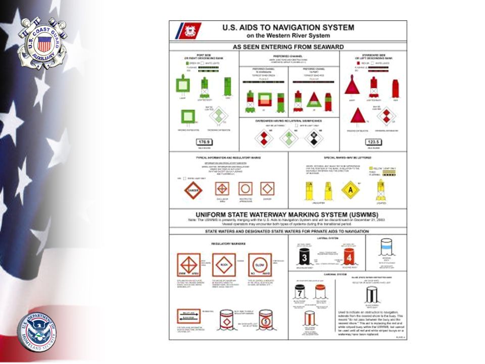
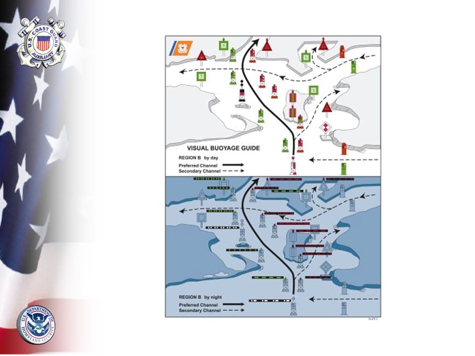
Navigation Aids Lateral aids or marks indicate the sides and center of the channel –“Red right returning” rule of lateral marking –Safe water or mid channel marks –Day beacons –Lighted beacons

33
Navigation Aids Informational aids mark dangers or note local rules –No-wake zones –Barge moorings –Anchorage areas –Wing dams on rivers –Rocky areas –Swimming beaches

34
Day Beacons Day beacons are unlighted fixed navigation aids –Indicated on a chart by a green square or red triangle –May be on land or in shallow waters on poles

36
Lighted Beacons Lighted fixed navigation aid indicated on a chart by a symbol that resembles an exclamation mark –Solid black dot indicates actual position –Magenta teardrop flare indicates it is lighted

37
Characteristics of Lighted Beacons Characteristics are printed next to the symbol –Pattern of “4s” mean 4 second intervals –Colors of “R” (red), “G” (green), “Y” (yellow), and “W” (white) –Height of the aid –Visible range of the aid
, G (green), Y (yellow), and W (white) –Height of the aid –Visible range of the aid")
39
Light Patterns Certain navigational aids have prescribed light patterns Lighted center channel buoy flashes a Morse code “A” (short-long) pattern with white light Junction buoy will flash a two short plus one short (2+1) pattern either red or green
 pattern with white light Junction buoy will flash a two short plus one short (2+1) pattern either red or green")
40
Buoys Buoys have a small, open, black circle with a diamond flare Color of the buoy is given in the label –“R” = red, “G” = green, “RW” = red/white

42
Buoys Nun buoy (“N”) is conical is shape and red in color Can buoy (“C”) is cylindrical and green in color Mid channel buoy has red/white vertical stripes and a white light
 is conical is shape and red in color Can buoy ( C ) is cylindrical and green in color Mid channel buoy has red/white vertical stripes and a white light")
43
Other Buoys Sound-making buoys –Bell buoys –Gong buoys –Siren buoys Light colors may be red, green, or white

44
Plotting Tools Dividers Parallel rules Protractor Tool kit

45
Dividers Used to measure distances Used to measure latitude and longitude coordinates Drawing compass is similar to dividers

46
Determining Latitude Coordinate One point is placed on spot of interest and other point is on a line of latitude Divider is transferred to latitude scale –Read as degrees, minutes, and 1/10ths of minutes north (N)
")
47
Measuring Distance Using Dividers One point is placed on each end of the distance Divider is transferred to distance scale to determine the distance measurement

48
Measuring Distance Using Dividers Remember: Most charts have distance scales in nautical miles, statute miles, and kilometers. On the water, use nautical miles because of the natural relationship with latitude

49
Measuring Distance Using Dividers Distance longer than dividers? –“walk” your dividers along the distance line

50
Parallel Rules Consists of a pair rules joined by two or more swinging hinges Serve as a straight edge for plotting Helps transfer a plotted bearing line across the chart to compass rose

51
Rolling Parallel Rules One straight edge Moves across the chart on a long roller

52
Protractor Plotting Tool Easier to use than parallel rules particularly in cramped spaces

53
Drawing compass Calculator Notebook Pencils/erasers Waterproof sleeves for charts Navigation Tool Kit

54
Other Navigation Tools Ship’s compass Hand bearing compass Global Positioning System (GPS) Other electronics
 Other electronics")
55
The Ship’s Compass Every boat should have a compass. Quality and size are important Deviation must be adjusted for and done by a professional

56
A handheld magnetic compass with a built in sight Used to take visual bearings Always use the compass from a single spot near the helm Hand Bearing Compass

57
Global Positioning System (GPS) Most popular electronic navigation system Must have a clear view of the sky above the boat and be able to receive simultaneous satellite signals Remember: A GPS position is just an abstraction until it is plotted on a chart!
 Most popular electronic navigation system Must have a clear view of the sky above the boat and be able to receive simultaneous satellite signals Remember: A GPS position is just an abstraction until it is plotted on a chart!")
58
Other Electronic Devices Radar –Powerful and versatile tool for fixing positions using bearings and ranges –Only electronic device for tracking other vessels Depth sounder –Tells the depth of water directly under your boat –Useful to compare depth readings with chart soundings

59
Other Electronic Devices Fluxgate compass –Helps eliminate potential errors caused by friction of compass card –Self-compensate for local magnetic variation Autopilot –Mechanical device that controls the boat’s rudder –Must be connected to a fluxgate compass or GPS device

60
Other Electronic Devices VHF radio –Valuable tool especially in emergencies –New radios include a digital selective calling (DSC) function –DSC transmits your position when a call is made –Assists the USCG in determining your position
 function –DSC transmits your position when a call is made –Assists the USCG in determining your position")
61
Summary Nautical charts –Depths –Scales –Updates –Chart grid –Horizontal datum –Coordinates –Symbology

62
Summary Navaids –Beacons –Buoys Plotting tools –Dividers –Parallel rules –Protractor –Tool kit Compasses –Ship’s compass –Hand bearing compass Other navigation tools –GPS –Radar –Depth sounder –Fluxgate compass –Auto pilot –VHF radio

Similar presentations


.>")


>")


