Download presentation
Presentation is loading. Please wait.

1
Earth’s Water The Hydrospere Goal 2.3

2
Lesson 1 The Hydrosphere and the Water Cycle

3
Think About It… Why is it that the water in your bottle could have been drunk by George Washington?

4
Focus Questions… What are the processes involved in the water cycle? What is the connection between ground and surface water?

5
The Hydrosphere: An Overview… 1. The hydrosphere is… the water on and in Earth’s crust 2. The percentage of water found in the oceans… 97 We don’t call ourselves the Blue Planet for nothing! The percentage of water contained by the landmasses… 3 http://www.earthview.pair.com/earth300color.jpg

6
Of the Freshwater on Earth… 3. 90% is in the form of… polar ice caps and glaciers Most of the remaining water is… groundwater Only a small fraction is in… rivers, streams, and lakes http://adventure.nationalgeographic.com/adventure/trips/family-trips/glacier-bay-alaska/ Alaska’s Glacier Bay

7
4.The World’s Water Supply… Oceans – 97.2% - hundred of thousands of years Ice caps and glaciers – 2.15% - tens of thousands of years Groundwater -.31% - hundreds to thousands of years Lakes -.009% - tens of years Atmosphere -.001% - nine days! Rivers and streams -.0001% - two weeks How long will our supply last?

8
The Water Cycle… http://www.euwfd.com/html/hydrological_cycle.html

9
5.The Water Cycle… 1.Evaporation 2.Condensation 3.Precipitation 4.Infiltration (percolation) 5.Transpiration
 5.Transpiration")
10
6. Evaporation Liquid water from ocean, lakes and streams turns to water vapor

11
7.Condensation Water vapor in atmosphere turns into liquid water on dust particles clouds

12
8.Precipitation Water from clouds –Rain –Sleet –Snow –hail

13
9.Infiltration - percolation Water on the ground seeps into the soil and becomes ground water.

14
10.Transpiration Water from plants exit leaves through the stoma

15
11.How does surface water become ground water? Surface water infiltrates though the soil into the aquifer. An aquifer is a permeable area of rock that can contain or allow ground water to pass through.

16
How does ground water become surface water

17
12.Where does groundwater eventually flow? River, lake or ocean

18
Runoff… 13. Runoff is… water flowing down slope along Earth’s surface http://myecoproject.org/wp-content/uploads/2009/02/stormwater.jpg

19
14. Five Factors that Increase Runoff… a. Little to No Vegetation… Topsoil is easily eroded and water runs off easier

20
14. Five Factors that Increase Runoff… b. Heavy rain… Water falls too quickly to soak into the ground http://luirig.altervista.org/cpm/albums/nrcs3/normal_1389-Runoff-from-a-heavy-rain-carries-topsoil-from-a-cr.jpg

21
14. Five Factors that Increase Runoff… c. Soil with a lot of clay … Clay prevents water from soaking in b/c of its low porosity.

22
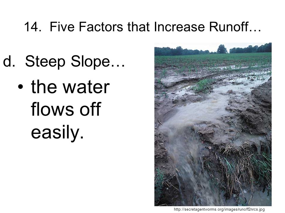
14. Five Factors that Increase Runoff… d. Steep Slope… the water flows off easily. http://secretagentworms.org/images/runoff2nrcs.jpg
23
14. Five Factors that Increase Runoff… e. High ground- water levels… There is no room for the water to infiltrate the ground. http://secretagentworms.org/images/runoff2nrcs.jpg

24
Watersheds and Stream Systems… 1. A stream is runoff water that begins to flow more permanently in a channel. a.A large stream is called a river. b.The smaller streams that feed into it are called tributaries

25
The Rivers of North Carolina…

26
Watersheds and Divides… 2. A watershed is all of the land area whose water drains into a stream system. http://dutchesswam.files.wordpress.com/2010/05/watershed-image-small.png

27
North Carolina Watersheds… http://www.learnnc.org/lp/media/maps/nc/Watersheds-NC-map.jpg

28
Watersheds and Divides… 3. A divide is a high land area that separates one watershed from another. The Eastern Continental Divide is located in the Blue Ridge Mountains.

29
Divides of North America… http://en.wikipedia.org/wiki/Eastern_Continental_Divide

30
Watersheds and Divides… 4. The watershed of the Mississippi River is the largest watershed in North America! http://www.epa.gov/gmpo/lmrsbc/index.html

31
Lesson 2 Surface Water: Rivers

32
Think About It… Why are rivers important? Have you ever been swimming, boating, rafting, tubing, or fishing in a river?

33
Focus Questions… What is the structure and function of a river? What causes a river to flood? How do rivers cause erosion and deposition?

34
Erosional Stream Load… 1. All the materials that the water in a stream carries is known as the stream’s load. http://upload.wikimedia.org/wikipedia/commons/9/9c/Stream_Load.gif

35
Erosional Stream Load… Three ways in which a stream carries its load... a.Material is carried in solution after it becomes dissolved in a stream’s water. b.All particles small enough to be held up by the turbulence of a stream’s moving water are carried in suspension. c.Sediments that are too large or heavy to be held up by turbulent water are transported as a stream’s bed load.

36
Erosional Stream Load…

37
2. Carrying capacity is the ability of a stream to… transport material http://water.weather.gov/ahps2/images/hydrograph_photos/muri2/muri2_2.jpg

38
Floods… 3. When do floods occur? when water spills over the sides of a stream’s banks onto adjacent land (Soccer fields were built on the flood plain of the Yadkin River in Davie County. Why?) http://www.nowpublic.com/world/floodplain
")
39
Floods… 4. How are floods related to groundwater levels? … It is more likely to flood when groundwater levels are high because… … the aquifer is already full and can only hold so much water. … the dotted line on the diagram represents the groundwater level. http://www.sciencedirect.com/science/article/pii/S004896970800380X

40
Floods… 5. Which agency monitors potential flood conditions? The National Weather Service monitors changing weather conditions. USGS has established gauging station on more than 4400 streams in the USA! http://pubs.usgs.gov/fs/2005/3113/images/Cropped_bridge.jpg

41
Stream Systems: Beginning… 1.The beginning of a stream is called the headwaters or source. a.Found in mountains b.Cold, oxygenated, clear c.V-shaped channels i.have steep sides. ii.The Grand Canyon is a V- shaped valley. The Grand Canyon http://media-3.web.britannica.com/eb-media/78/3078-004-9B8860F2.jpg

42
Stream Systems: Middle… 2. What is a floodplain? … a broad, flat, fertile area extending out from a stream’s banks that is covered with water during floods. … It is not wise to build on a floodplain because it is prone to flooding!

43
Stream Systems: Middle… a. A bend or curve in a stream channel is a - meander The Yadkin River http://www.wfae.org/wfae/images/Yadkin.jpg The Cape Fear River http://www.wilmingtonbeachrentals.com/2010/02/cape-fear-river-facts-pictures.html

44
Meandering Streams – A Diagram

45
Oxbow Lakes… c. An oxbow lake is… a blocked-off meander We have our very own oxbow lake in the Carolinas – in the Congaree National Park just outside of Columbia, SC. http://www.daviddarling.info/images/oxbow_lake.jpg

46
Oxbow Lakes… Oxbow Lakes in Alaska http://www.alaska-in-pictures.com/oxbow-lake-aerial-3405-pictures.htm Oxbow Lake in the Amazon http://muller.lbl.gov/travel_photos/AmazonWebPages/AmazonWebPages-Pages/Image1.html

47
Stream Systems: The End!… 3. The end of a stream is called the mouth … and is usually located at the ocean or another large body of water http://carolinagreensense.com/uploaded_images/NIWB-731140.jpeg

48
(Yadkin)- PeeDee River A Bigger View!
- PeeDee River A Bigger View!")
49
A Stream’s End: Deposition of Sediment… a. Streams lose their ability to carry sediment …b/c they lose velocity b. An alluvial fan is a fan-shaped deposit commonly found in mountains. Alluvial Fan in the Sonora Desert http://practicalbio.blogspot.com/2011/09/sonoran-desert-soil-distributions.html

50
A Stream’s End: Deposition of Sediment… c. A delta is a triangular deposit that forms where a stream enters a large body of water. The city of New Orleans is on the Mississippi River Delta. The Mississippi River Delta – picture taken by Landsat 7 http://earthasart.gsfc.nasa.gov/mississippi.html

51
Formation of Stream Valleys… http://www.indiana.edu/~geol116/week9/rivprof.jpg Next 3 slides

52
Stream Systems: Middle… b. Water in a stream flows fastest… I.Along the center II.Outside of a meander

53
What is our river?

54
What river drains the largest watershed in the USA

55
What river waters most of the produce in California? The Colorado River

56
Lesson 3 Lakes

57
Think About It… What is the biggest lake you have ever seen in person?

58
Focus Question… How do dams create reservoirs and how is the water in a reservoir used by people? What can cause eutrophication or pollution in a lake?

59
Lakes… 1. What is a lake? o a depression in land that holds water a. What determines where a lake can form? o the surface materials b. Why are lakes important? o Recreation, drinking water, habitats d. What is a reservoir? o a manmade lake http://en.wikipedia.org/wiki/High_Rock_Lake High Rock Lake http://www.city-data.com/picfilesv/picv23839.php

60
Types of Lakes… Oxbow Lake… a meander gets cut off Weston Lake (Oxbow) in Congaree National Park
 in Congaree National Park")
61
The Great Salt Lake in Utah - the remains of a sea http://www.americansouthwest.net/utah/salt_lake_desert/salt_l.html

62
Moraine-dammed Lake - glacial melt is dammed by a moraine http://pubs.usgs.gov/of/2004/1216/i/i.html Moraine-dammed Lake in Alaska

63
Kettle Lakes - Glacial melt in a depression created by the glacier http://www.geo.msu.edu/geogmich/kettle_lakes.html Kettle Lakes in Michigan

64
Lakes Undergo Change… 2 a. What maintains a lake’s water supply? o rain, runoff, and groundwater 2 b. A lake will exist for a long time if… o it gets more water than it loses After a long time a lake will dry up and fill up! The Aral Sea: Uzbekistan http://earthobservatory.nasa.gov/IOTD/view.php?id=1396

65
Lakes Undergo Change… 3. Eutrophication is… o excess nutrients cause the overgrowth of algae which use up oxygen in the lake The process of eutrophication can be sped up by… o over-fertilizing land near a waterway Fish kill in the Salton Sea, CA Eutrophication in Australia http://www.eoearth.org/article/Eutrophication

66
Eutrophication Explained … http://library.thinkquest.org/04oct/01590/pollution/culturaleutroph.jpg

67
Lakes Undergo Change… 4. Four things that can pollute lakes are… o animal wastes o phosphate detergents o industrial toxins o untreated sewage

68
Lesson 4 Freshwater Wetlands

69
Think About It… What would happen if all of our coastal wetlands were filled in for homes and hotels?

70
Focus Question… Why are wetlands important? What factors affect and degrade wetlands and estuaries?

71
Freshwater Wetlands… 5. A wetland is… o land that is soaked with water Three examples of wetlands are… a.bogs b.marshes c.swamps Boardwalk at Bethabara Park Our very own wetlands! http://www.tommangan.net/twoheeldrive/index.php/2009/11/29/easy-hike-at-historic-bethabara-park/

72
Bogs… 1. A bog is a water-soaked area with poor drainage. Water in a bog comes from… o Precipitation (rain) 2. The soil in a bog is acidic because… o of the decaying moss – This slows bacterial growth which prevents nitrogen recycling. http://water.epa.gov/type/wetlands/bog.cfm A bog in Alabama http://here4now.typepad.com/here4now/2011/05/weeks-bay-reserve.html
 2. The soil in a bog is acidic because… o of the decaying moss – This slows bacterial growth which prevents nitrogen recycling. A bog in Alabama")
73
Bogs… 3. Interesting plants that live in a bog are the… o Venus fly trap o Sun dew o Pitcher plants These plants are carnivorous b/c of the nutrient-poor soil of the bog. They must digest insects to obtain nitrogen. http://www.duke.edu/~jspippen/plants/carnivorousplants.htm

74
Marshes… 7. A marsh is a water- soaked area at the mouth of streams. Fresh water marshes and estuaries often form… o At the mouth of a river Marsh grasses have shallow roots that … o anchor silt and mud deposits in a delta. (Builds land!) Brackish marsh near Wanchese, NC http://www.duke.edu/~jspippen/vistas/outerbanks.htm
 Brackish marsh near Wanchese, NC")
75
Marshes… 7. Plants found in a marsh include… o Grasses o Reeds o Sedges o Rushes These plants provide shelter and food for aquatic larva. Marsh with reeds and rushes - natural reserve near Ravenna, Italy

76
Swamps… 8. A swamp is… o a low-lying area near a stream Swamps may develop from marshes that have filled in to support the growth of shrubs and trees. Congaree National Park, SC http://vogeltalksrving.com/wp-content/uploads/2011/12/Mosquito-meter.jpg

77
Water Lily in Bok Tower Gardens, Orlando, FL … http://attractionsmagazine.com/blog/2012/09/14/water-lilies-seem-to-big-to-be-true-at-bok-tower-gardens/

78
Swamps… 8. Trees that grow in a swamp include… o mangrove trees o cypress trees Mangroves in Biscayne National Park, FL Bald Cypress Trees in Florida

79
Swamps… If a swamp were to be buried under tons of sediment…coal might form! http://www.learner.org/courses/envsci/visual/visual.php?shortname=coal_formation

80
Environmental Issues: A Loss of Habitat… 9. Two valuable functions of wetlands … o the filtering of water o providing a habitat for migrating birds and fish fry (fish babies!) 10. What % of our wetlands were lost from the late 1700s to mid- 1980s? o 50 % o Why? http://www.pwconserve.org/wildlife/birds/snowgoose.htm Snow Geese in Prince William Sound
 10. What % of our wetlands were lost from the late 1700s to mid- 1980s. o 50 % o Why. Snow Geese in Prince William Sound.")
81
Environmental Issues: Upstream Drought… 10. A drought upstream … o … will lead to less fresh water entering the estuary and… o … saltier water http://www.pwconserve.org/wildlife/birds/snowgoose.htm Snow Geese in Prince William Sound

82
Environmental Issues: Saltwater Intrustion… 10. Overused wells in coastal areas … o … may draw up salt water from the ocean and … o … cause the water to become undrinkable. http://www.pwconserve.org/wildlife/birds/snowgoose.htm Snow Geese in Prince William Sound

83
Three Ways to Preserve Wetlands… Education Conservation Regulation

84
Lesson 5 The Movement and Storage of Groundwater

85
Think About It… Does your family drink well water?

86
Focus Question… How does groundwater move through the lithosphere? How are flood events affected by groundwater levels?

87
Precipitation and Groundwater… Remember the water cycle? 1.Most water in the atmosphere comes from oceans! 2.Most precipitation that falls on land becomes groundwater. 3. Eventually groundwater will… … return to the ocean to complete the water cycle.

88
Groundwater Storage…. Porosity is… …the percentage of pore space in a material 4. The types of soil that have - highest porosity - well- sorted lowest porosity – poorly- sorted 5. Groundwater is stored… in the pore spaces of rocks and sediments (See picture ) …and can be compared to a hard sponge http://core.ecu.edu/geology/woods/GWANSW2008_files/image002.jpg
 …and can be compared to a hard sponge")
89
Groundwater Storage… 6. The zone of saturation is… the depth below Earth’s surface at which groundwater completely fills all the pores 7. The water table is … …the upper boundary of the zone of saturation

90
e. Figure 10-2: Groundwater Storage (p. 421) soil Zone of aeration Zone of saturation Water table
 soil Zone of aeration Zone of saturation Water table")
91
Groundwater Storage… 8. The depth of the water table varies… …in swampy areas- water table is almost at surface, …in arid regions - water table is far beneath surface Green Swamp, FL

92
Groundwater Storage… 9. If the water table is high, it is more likely to flood. low, it is less likely to flood. 10. The water table fluctuates with the seasons and weather conditions because… it depends on rain to recharge it http://www.tulane.edu/~sanelson/images/chwattab.gif

93
Groundwater Movement: Permeability… 11. What is permeability? the ability of a material to let water pass through it 12.What subsurface materials are permeable? sand, sandstone, and gravel 13.What subsurface materials are impermeable? clay, silt, and shale 14.Why is clay used to line ponds & landfills? It is impermeable (our storm drainage pond)
.")
94
Groundwater Movement: Aquifers… 15. An aquifer … underground storage area for water made of permeable rock layers. 16. An aquiclude … impermeable layer above or below an aquifer.

95
Groundwater Movement… 6. aquifer 7. 8. aquiclude

96
Groundwater: A Music Video… The Story of Groundwater! http://www.groundwater.org/kc/groundwat er_animation.htmlhttp://www.groundwater.org/kc/groundwat er_animation.html

97
Lesson 6 Groundwater Erosion

98
Think About It… Why do some homes in Florida get swallowed up by the ground?

99
Focus Question… What are the unique features of caves? What features are found in an area with Karst topography?

100
Caves… 1.What is a cave? A natural underground opening with a connection to Earth’s surface 2.Which acid forms caves? Carbonic acid (H 2 O + CO 2 in the soil) 3.Which rock is eroded by this acid to form a cave? limestone
 3.Which rock is eroded by this acid to form a cave. limestone.")
101
Caves of the USA… http://giantcrystals.strahlen.org/america/lechuguilla.htm Lechuguilla Cave, N. MexicoCarlsbad Caverns, N. Mexico http://en.wikipedia.org/wiki/File:Witchs_Finger_Carlsbad_Caverns.jpg Mammoth Cave, Kentucky http://www.britannica.com/blogs/2011/07/dark-depths-mammoth-cave/

102
Mammoth Cave: A Closer Look… http://images.travelpod.com/users/socks/1.1248576883.mammoth-cave-river-styx-tour-route.jpg

103
Cave Formations… http://www.cr.nps.gov/history/online_books/orca/underworld/sec1b.htm

104
Karst Topography: Sinkholes… 1. What is a sinkhole? A depression in the ground caused by the collapse of a cave http://southea stsinkhole.co m/http://southea stsinkhole.co m/

105
Karst Topography 2. Karst topography are limestone regions that have sinkholes, sinks, and sinking streams – named for an area in Croatia. A aerial photograph of a classic Karst terrain north of Lewisburg, WV http://www.virginiacaves.org/lok/ccvup56.htm

106
Karst Topography…

107
Karst Topography http://www.mospeleo.org/ozark_caving/springs/sprkarst.htm Missouri

108
Hard Water… 4. Hard water is water that contains high concentrations of calcium, magnesiun, or iron. Common in limestone areas Causes deposits of calcium bicarbonate and can clog water pipes. (p. 247) More soap must be used
 More soap must be used.")
109
Lesson 7 Groundwater Systems, Use, and Threats!

110
Think About It… Where does the water in a spring come from?

111
Focus Question… What are the unique features of springs? How can the use of wells lead to aquifer depletion, subsistence, and saltwater intrusion? What are threats to our groundwater?

112
Springs… 1.Ground water discharges at… Earth’s surface These natural discharges of water are called…springs 2.Water may flow out of a rock when… an aquifer and an aquiclude come in contact

113
Ponce De Leon Springs http://www.eyekonic.net/gallery2/d/1232-2/Ponce_20De_20Leon_20Springs_202.jpg

114
Location of Springs: B. Perched Water Table http://www.physicalgeography.net/fundamentals/8m.html A. Near Horizontal Sedimentary Layers C. Fault-blocked D. Limestone Regions

115
Hot Springs… 3. The temperature of ground water is… the same as the average annual temperature 4. Hot springs are… springs which have temperatures higher than the human body Hot springs are so hot because… the subsurface is still hot from recent igneous activity Picture on next slide

116
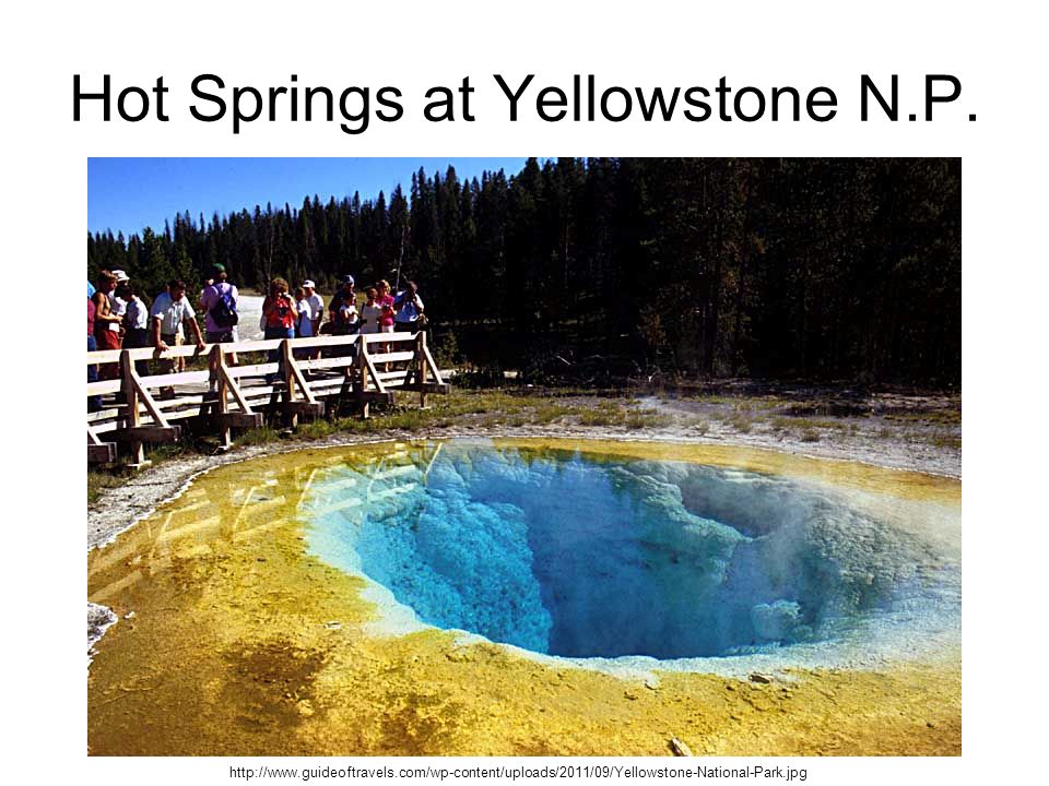
Hot Springs at Yellowstone N.P. http://www.guideoftravels.com/wp-content/uploads/2011/09/Yellowstone-National-Park.jpg
117
Springs and Geysers… 5. Most hot springs in our country are found in the… western states 6. A geyser is an … explosive spring that erupts at regular intervals Old Faithful Geyser Yellowstone NP http://www.gogobot.com/old_faithful_geyser_and_upper-yellowstone_national_park-attraction

118
Wells… 1. A well is… a hole dug to reach a reservoir of groundwater 2. A cone of depression is produced by… the over pumping of wells 3. Drawdown is… the difference between the original water table level and that of a pumped well 4. Recharge is… when water from rain or runoff is added to an aquifer

119
Wells… 5. An artesian well flows from a deep, confined aquifer which contains water under pressure.

120
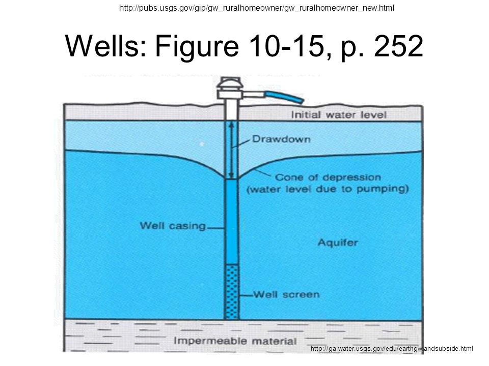
Wells: Figure 10-15, p. 252 http://pubs.usgs.gov/gip/gw_ruralhomeowner/gw_ruralhomeowner_new.html http://ga.water.usgs.gov/edu/earthgwlandsubside.html
121
Wells… 6.The entire water table can be lowered due to… 6.The overuse of wells 7.Ground above an overused well can… …sink! This is called subsidence

122
Threats to Our Water Supply… 1. Overuse 2. Subsidence (sinking land over an aquifer) 3. Pollution in groundwater (sewage, industrial waste, landfills, agriculture) 4. Chemicals (not filtered out by sediments; hard to remove from groundwater) 5. Salt (one of the major threats to groundwater supplies; esp. coastal areas) 6. Radon (generated by radioactive decay of uranium in rocks – esp. granite and shale)
 4. Chemicals (not filtered out by sediments; hard to remove from groundwater) 5. Salt (one of the major threats to groundwater supplies; esp. coastal areas) 6. Radon (generated by radioactive decay of uranium in rocks – esp. granite and shale).")
123
Protection of Groundwater… 1.Identify and eliminate pollution sources. 2.Monitor pollution. 3.Pump groundwater to surface and treat it.

124
Lesson 8 Use, Abuse, and Conservation of Water Resources

125
Water Use: The Importance of Water 1.Four important uses of freshwater… Agriculture, transportation, recreation, drinking! 2.Water is indispensable for life on Earth because… 1.It exists as a liquid 2.It stores a lot of heat 3.It is the universal solvent 4.Solid water expands

126
The Importance of Water… 3.Eastern states get the most precipitation. 1.Eastern states - cooling, energy production, and manufacturing. 2.Western states - irrigation. 4.Withdrawal rates of freshwater are increasing each year because… …our population is growing!

127
Western states use more water for growing their crops…

128
Use of Water in the USA… http://fracfocus.org/sites/default/files/water-use-pie-chart.jpg

129
Managing Freshwater Resources 1.Dams are built to… … control flooding downstream and to manage freshwater resources 2.In the USA, 23% of all freshwater is obtained from… … aquifers (groundwater) … Florida, Hawaii, and Nebraska depend almost entirely on groundwater.
 … Florida, Hawaii, and Nebraska depend almost entirely on groundwater.")
130
Managing Freshwater Resources 3.Drawdown causes… a.wells to go dry b.streams to run low or go dry c.shallow aquifers on the coast to get salty (This is called salt water intrusion) 4.Desalination is removing salt from seawater to make freshwater. It is not practical due to high costs. See next slide…

131
Saltwater Intrusion… http://www.wrd.org/engineering/images/seawater-intrusion.gif

132
Desalination… http:// www.tampabaywater.org/tampa-bay-seawater-desalination-plant.aspx

133
Water Pollution: Types of Pollution… … 1.Point sources … …have a single point of origin (often a piped discharge) …Three examples include (but aren’t limited to)… a.sewage b.spills c.industry Drainage into the Ohio River http://www.waterencyclopedia.com/Po-Re/Pollution-Sources-Point-and-Nonpoint.html http://www.lakescientist.com/learn-about-lakes/water-quality/pollution.html
 …Three examples include (but aren’t limited to)… a.sewage b.spills c.industry Drainage into the Ohio River")
134
Water Pollution: Types of Pollution … 2. Nonpoint sources … … come from widely spread areas and cannot be identified and cleaned up as easily. … Two examples include (but aren’t limited to)… a.pesticides and fertilizers from farms and yards b.oil and gasoline from parking lots http://oceanservice.noaa.gov/education/kits/pollution/media/pol04a_460.jpg
… a.pesticides and fertilizers from farms and yards b.oil and gasoline from parking lots")
135
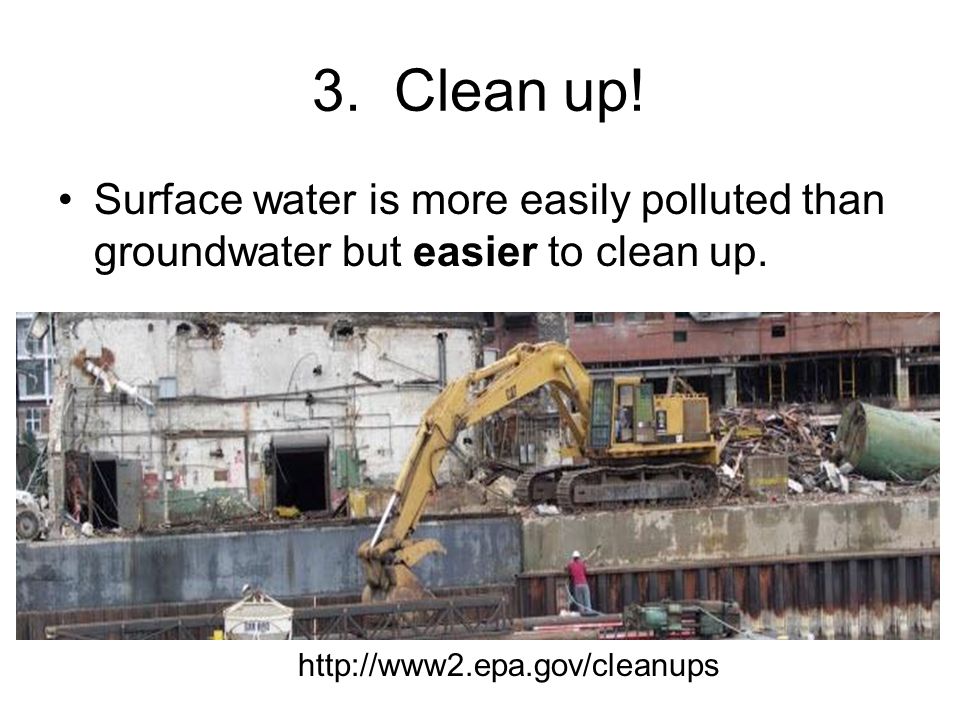
3. Clean up! Surface water is more easily polluted than groundwater but easier to clean up. http://www2.epa.gov/cleanups
136
Reducing Water Pollution… 1.The Safe Drinking Water Act (1974) was designed to … … ensure our citizens have safe drinking water … Our water does not always meet these standards. 2.The Clean Water Act (1972) was created to… a.eliminate sources of water pollution b.restore water quality (which it has done!)
 was created to… a.eliminate sources of water pollution b.restore water quality (which it has done!).")
137
Water Conservation 1. Community Water Conservation… a.Farmers can use irrigation techniques like trickle irrigation to save water. http://www.tricklering.com/ http://www.tricklering.com/ b.Industries can use recycled or gray water to save water. 2.Personal Conservation: How can you and I conserve water in our homes and yards?

138
Lesson 7 Video Clip… The Cycle of Insanity: The Real Story of Water http://www.rivernetwork.org/blog/7/2010/04/12/new-surfrider-video- shows-%E2%80%98-real-story-water%E2%80%99http://www.rivernetwork.org/blog/7/2010/04/12/new-surfrider-video- shows-%E2%80%98-real-story-water%E2%80%99

139
Yadkin Riverkeeper Website… The Yadkin Riverkeeper organization is a member of the international Waterkeeper organization. This alliance includes baykeepers, deltakeepers, riverkeepers, lakekeepers, etc. http://www.yadkinriverkeeper.org/content/v ideo-messageshttp://www.yadkinriverkeeper.org/content/v ideo-messages

Similar presentations


