Download presentation
Presentation is loading. Please wait.

1
WHAT IS A DISASTER? Disaster is a natural or man- made, sudden or accidental event (Hazard) that results in many deaths, injuries and significant property damage, relative to existing conditions.
 that results in many deaths, injuries and significant property damage, relative to existing conditions..")
2
DISASTER CLASSIFICATION AND PATTERN Natural Disasters – Include earthquakes, floods, hurricanes and typhoons, and tornadoes, Tsunamis, volcanic eruptions, wildfires, and landslides and avalanches rank among the others. Man-made Disasters – could be either accidental or intentional, e.g. accidents aboard passenger- carrying airplanes, ships, or railroads, collapse of buildings, bridges, tunnels, and mines, explosions and fires, War and terrorism. Quick onset pattern – Occurs discretely without warning e.g. earthquakes and volcanoes, and are often of catastrophic dimensions. Slow/long onset pattern – continuous with less apparent effects e.g. natural radioactivity or naturally occurring toxic metals, climatic hazards like storms, damage to coastlines, droughts, floods, snow, hail, lightning, and natural fires.

3
Hazard and Vulnerability Hazards – A hazard is a TRIGGER – EVENT that sets off the disaster, e.g. Seismic hazard or conflict (natural or man–made) Vulnerability – How safe or unsafe the physical structures of the environment is (Safe or unsafe conditions) – The trigger event must come in touch with Unsafe Conditions, which makes a population vulnerable to that particular hazard. – The state of the conditions determines the magnitude of the disaster In effect; DISASTER = Hazard + Vulnerability
 Vulnerability – How safe or unsafe the physical structures of the environment is (Safe or unsafe conditions) – The trigger event must come in touch with Unsafe Conditions, which makes a population vulnerable to that particular hazard. – The state of the conditions determines the magnitude of the disaster In effect; DISASTER = Hazard + Vulnerability.")
4
THE DISASTER CYCLE THE RECOVERY PROCESS Primary concerns of the disaster. Relief: Satisfy the immediate and basic needs of disaster survivors such as for food, clothing, shelter, medical care and emotional security. Rehabilitation: restoration the basic services necessary to enable the population to return to pre-disaster conditions, e.g. provision of seeds or enabling the re-starting of businesses. Reconstruction: Reconstruction of buildings, with safety as an important element, bringing the situation to normal conditions. THE PROTECTION PROCESS Preparing against any future disasters, having learnt from the past. Mitigation: It is a form of preventative action for risk reduction. Preparedness: Includes planning measures and contingency measures.

5
THE MAJOR CLASSES OF HAZARD TYPES IN GHANA Pests and Insect Infestation Hazards – Crops, Stored Food, Timber, Livestock and Poultry – Disease (Epidemic) Hazards – Cerebrospinal Meningitis (CSM), Cholera, Yellow Fever Fires and Lightning Hazards – Domestic Fires, Industrial/Commercial Fires, Ecological (Bush Fires), fires caused by Lightning etc. Hydro – Meteorological Hazards – Rainfall/runoff Flooding, River/Lagoon Flooding, Tidal Flooding, Man-made Flooding (Dam burst spillage, Blocking of river courses, etc.), Tsunamis, Rain/Wind storms, Droughts Geological Hazards – Earthquakes, Landslides (MM), Soil Erosion, Expansive Soils, Coastal Erosion, Ground Subsidence Man-made Hazards – Failure of Structures including Buildings, Mines and Dams, Ethnic Conflicts/Wars, Industrial Accidents, Aviation and Maritime Accidents, Pollution of Water Systems from mining and other activities, Air Pollution, Oil Spillage, Radioactive Leakage, Deforestation / Desertification
, Tsunamis, Rain/Wind storms, Droughts Geological Hazards – Earthquakes, Landslides (MM), Soil Erosion, Expansive Soils, Coastal Erosion, Ground Subsidence Man-made Hazards – Failure of Structures including Buildings, Mines and Dams, Ethnic Conflicts/Wars, Industrial Accidents, Aviation and Maritime Accidents, Pollution of Water Systems from mining and other activities, Air Pollution, Oil Spillage, Radioactive Leakage, Deforestation / Desertification.")
6
EARTHQUAKE Earthquake is the shaking of the Earth’s surface as result of rapid movement of the Earth’s rocky outer layer, due to the release of energy stored in the form of strain in rocks. This energy is transmitted to the surface of the Earth by earthquake waves. The study of earthquakes and the waves they create is called seismology The Scientists who study earthquakes are called Seismologists.

7
Types Two Types; namely, tectonic and volcanic Tectonic: Caused by the sudden release of energy stored within the rocks along a faults. Volcanic: Caused by the upward movement of magma under the volcano, which strains the rock locally and leads to an earthquake. Effects/Casualty The destruction an earthquake causes depends on its magnitude and duration i.e the amount of shaking that occurs Earthquakes vary from small, imperceptible shaking to large shocks felt over thousands of kilometers

8
Geographical location and Environment for occurrence (Refer to Introductory Plate Tectonics

9
Basic principles They occur along faults, planar breaks in rock along which there is displacement on one side, relative to the other They happen when that displacement occurs suddenly in response to stress. Stress when force is applied to an object. Stress may be compressive, squeezing the object, or may be tensile, pulling the object apart. Shearing stress is one that causes different parts of the object to move in different directions across a plane, or to slide past one another. Strain is deformation resulting from stress The deformation may be elastic or non-elastic Non-elastic results in plastic deformation and eventual rupture of rock to release energy. Ruptured rocks bounces back elastically in a process called Elastic rebound (Fig 1) In brittle rocks rupture occurs before any possible plastic deformation Plasticity occurs under high temperatures and confining pressure at depth (Fig 2)
 In brittle rocks rupture occurs before any possible plastic deformation Plasticity occurs under high temperatures and confining pressure at depth (Fig 2).")
10
FIGURE 1FIGURE 2

14
EARTHQUAKE TERMINOLOGIES The point on a fault at which the first movement or break occurs during an earthquake is called the earthquake's focus, or hypocenter. The point on the earth's surface directly above the focus is the epicenter. The line along which the fault plane intersects the earth's face is the fault trace. If there is vertical movement along the fault, the cliff formed is called a fault scarp. (Fig 3). FIGURE 3
. FIGURE 3.")
15
SEISMIC WAVES Seismic waves: Manifestation of released stored-up energy in rocks. Constitutes: – Body waves: (Primary or P waves and Secondary or S waves) travel through the interior of the earth. – Surface waves, (Rayleigh R and Love L waves) travel along the surface. Primary or P waves are compressional waves; travel through matter, where the matter is alternately compressed and expanded. Secondary or S waves are shear waves, involving a side-to-side sliding motion of material. Surface seismic waves are somewhat analogous to surface waves on water. They cause rocks and soil to be displaced in such a way that the ground surface ripples or undulates. – Rayleigh waves cause vertical (rolling) ground motions; – Love (L) waves cause horizontal (lateral) motions. Most earthquake damage is caused by surface waves, particularly those with shearing motion (Fig 4 and 5).
 travel through the interior of the earth. – Surface waves, (Rayleigh R and Love L waves) travel along the surface. Primary or P waves are compressional waves; travel through matter, where the matter is alternately compressed and expanded. Secondary or S waves are shear waves, involving a side-to-side sliding motion of material. Surface seismic waves are somewhat analogous to surface waves on water. They cause rocks and soil to be displaced in such a way that the ground surface ripples or undulates. – Rayleigh waves cause vertical (rolling) ground motions; – Love (L) waves cause horizontal (lateral) motions. Most earthquake damage is caused by surface waves, particularly those with shearing motion (Fig 4 and 5)..")
16
FIGURE 5 FIGURE 4

17
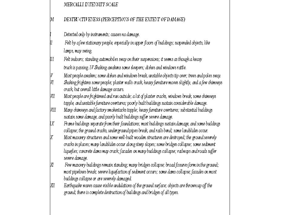
SIZES OF EARTHQUAKES Two most commonly used parameters for describing earthquake sizes are magnitude and intensity. Magnitude is Impact or Hazard based and relates the amount of ground shaking. Magnitude is reported using the Richter magnitude scale. The Richter scale is a logarithmic one, meaning that an earthquake of magnitude 4 causes ten times as much ground movement as one of magnitude 3, one hundred times as much as one of magnitude 2, and so (Table 1). Intensity (Vulnerability based) is a measure of the earthquake's effects on humans and on surface features The surface effects depends local geologic conditions, quality of construction, and distance from the epicenter. A single earthquake, then, can produce effects of different intensities in different places, though it will have only one magnitude assigned to it. Intensity is a somewhat subjective, rather than on instrumental measurements. Intensity is a more direct indication of the human impact of a particular seismic event in a given place than is magnitude. The most widely applied intensity scale in the United States is the Modified Mercalli scale (Table 2).
. Intensity (Vulnerability based) is a measure of the earthquake s effects on humans and on surface features The surface effects depends local geologic conditions, quality of construction, and distance from the epicenter. A single earthquake, then, can produce effects of different intensities in different places, though it will have only one magnitude assigned to it. Intensity is a somewhat subjective, rather than on instrumental measurements. Intensity is a more direct indication of the human impact of a particular seismic event in a given place than is magnitude. The most widely applied intensity scale in the United States is the Modified Mercalli scale (Table 2)..")
18
Richter Magnitude Scale m Effects Average number per yearApproximate Energy Equivalent 8.9 Absolute devastation (M = XII)0.03 m = 8.9 Approx. 3 billion tons of TNT 8.0- 8.8 Nearly total destruction (M = XI)0.1 m = 8.0 Approx. H-bomb (100 million tons of TNT) 7.4- 7.9 Great damage4 7.0- 7.3 Serious damage15 6.2- 6.9 Moderate to serious damage100 5.5- 6.1 Slight to moderate damage 500 m = 6.0 Approx. Atomic bomb (100,000 tons of TNT) 4.9- 5.4 Felt by all; slight damage1400 4.3- 4.8 Felt by many (M = V)4800 3.5- 4.2 Felt by some; recorded globally30000m = 4.0 Approx. 100 tons of TNT 2.0- 3.4 Not felt but recorded at a distance800000m = 2.0 Approx. Lightning bolt < 2.0 Not felt; recorded only locallymillions m = 1.0 Approx. Like a 2-ton truck driving by
0.1 m = 8.0 Approx. H-bomb (100 million tons of TNT) Great damage Serious damage Moderate to serious damage Slight to moderate damage 500 m = 6.0 Approx. Atomic bomb (100,000 tons of TNT) Felt by all; slight damage Felt by many (M = V) Felt by some; recorded globally30000m = 4.0 Approx. 100 tons of TNT Not felt but recorded at a distance800000m = 2.0 Approx. Lightning bolt < 2.0 Not felt; recorded only locallymillions m = 1.0 Approx. Like a 2-ton truck driving by.")
20
SEISMOGRAPHS AND EARTHQUAKE RECORDS Two basic configurations: A mechanical vertical-motion seismograph consists of a heavy weight (like a pendulum) suspended from a spring (Fig 6). – The spring connects to a sturdy frame that has been bolted to the ground. – A pen extends sideways from the weight and touches a vertical revolving cylinder of paper that has been connected to the seismograph frame. – When an earthquake wave arrives and causes the ground surface to move up and down, it makes the seismograph frame also move up and down. A mechanical horizontal seismograph works on the same principle, except that the paper cylinder is horizontal and the weight is suspended from a wire (Fig 6). Back- and-forth movement of this seismograph causes the pen to trace out waveforms. The wave train traced by the pen on a seismograph provides a record of the earthquake is called a seismogram (Fig 7 and 8). In order to be able to determine when a particular earthquake wave arrives, the record displays lines representing time.
. Back- and-forth movement of this seismograph causes the pen to trace out waveforms. The wave train traced by the pen on a seismograph provides a record of the earthquake is called a seismogram (Fig 7 and 8). In order to be able to determine when a particular earthquake wave arrives, the record displays lines representing time..")
21
FIGURE 6 FIGURE 7 FIGURE 8

22
EARTHQUAKE-RELATED HAZARDS Ground Shaking and Displacement – The destruction is by the surface waves (R and L), where damage depends on both nearness to source and also the nature of the substrate. – Snapping, crushing, twisting and buckling of structures occur to all forms of property and super structure. Landslides and Avalanches – Slumping, tumbling and flow of materials high up slopes – Attributed to the nature of material subjected to the shaking. Sediment Liquefaction – When clay-rich sediment has been slightly compacted, electric charges on the surface of these flakes stick the flakes together, trapping the water in pores between them. When the ground shakes, the motion un-sticks the clay flakes from one another, and the sediment becomes slurry of clay and water. Fire – Lamps, stove or candles with open flames tip over – Breaking of wire wires or toppling of power lines to create sparks. – Areas already turned to rubble, and even areas not so badly damaged, may be consumed by fire. Tsunamis – Fault slip displaces the sea-floor surface, to generate water wave in the overlying water that grows larger in amplitude as it drifts away – The moves can be immense, even though the vertical change in the elevation of the sea floor may be slight. Disease – Earthquakes cut water and sewer lines, destroying clean water supplies and exposing the public to bacteria, and they cut transportation lines, preventing food and medicine from reaching the city. – The bodies of victims may begin to rot, exposing survivors to additional contagious diseases.

23
Preparing for an Earthquake (Refer to Hazard Management and or Disaster cycle etc)
")
24
EARTHQUAKES IN GHANA Distribution and Historic Events Elmina -1615, Axim1636, Accra 1862, 1939 and 1995, Ho 1906 Regional trend Ghana lies to the southeastern side of the stable West African Craton, defined at the margins by the S- shape folded chain of the Upper pre-Cambrian rocks (Akwapimian –Togo – Atakorian - Nigerides - Southern Mauritenides – Falemedes -Rockellites series). Local trend Ghana’s seismicity is associated with active faulting, E-W trending Coastal Boundary Fault and the NE- SW Akwapim Fault Zones. The E-W coastal fault system that runs from the Sekondi area across to Keta area, Also a NE-SW trending fault system from south of Senya Beraku area running through Weija in to the Legon Hills and defines the East and West boundary fault system of the Akwapimian range, and also along the Akwapim range outlier system defined by the Asikum – Abutia – Kabakaba - Honuta ranges. This range split from the main Akwapim range in the Asikuma area and re-converges with it towards the north Honuta creating a double plunge system. The Coastal Fault intersects the Akwapim boundary fault system in the Weija area; hence the concentration of earthquake activities in that area. Stations Stations located at Legon, Tema, Weija, Winneba, Shai-Hills, Koforidua, Kukrantumi, Akosombo, and Ho. Inferences Continuous seismic recording since 1973 indicated that local seismic activity occurs at rate consistent with the recurrence of magnitude 6 earthquakes at intervals of 50 years or so. Southern Ghana, is seismically-active, with the south-eastern part being particularly more vulnerable to earthquake effects.

25
What to do during Earthquake Remain calm, try to reassure others and think through the consequences of any action you may take. When indoor, stay there. Watch for falling plaster, bricks, light fixtures and other “flying objects”. Stay away from mirrors, glass windows and doors and falling objects. When in danger get under a table, desk or bed in a corner away from windows, or in a strong doorway. Encourage others to follow your example. Usually it is best not to run outside. You cannot outrun a falling brick. When in a multi stored building, get under a desk, table or bed. Do not dash for exits or lifts, since staircases may be broken and jammed with people and power for lifts may fail. In a crowded classroom, shop, church or hall, do not rush for a doorway since hundreds of other people may have the same idea. Move away of from shelves containing objects that may fall. If you must leave the building choose your exit as carefully as possible. When outside, get into the open, away from buildings, trees, walls, power lines and other objects which could fall. Do not run through streets. If you are driving, pull to the side of the road and stop the vehicle. Do not park under bridges, trees or power lines. All passengers must remain in the vehicle until the earthquake is over. If the earthquake has been severe, do not attempt to cross bridges that have been damaged.

27
WASTE No universally accepted definition exists the material which has lost its value. All materials which are produced from economic activities of human being will lose their worth sooner or later

28
WASTE A useful definition: “Waste is a left-over, a discarded product or material of no or marginal value for the owner and which the owner wants to get rid of” The definition suggests that waste depends on time (e.g. new products/old), location (e.g. rural/small town vs. urban, climatic differences), culture (e.g. foodwise), social conditions (e.g. poor vs. rich) as well as political regulations (e.g. fees on disposable items: bag, packaging etc.)
, location (e.g. rural/small town vs. urban, climatic differences), culture (e.g. foodwise), social conditions (e.g. poor vs. rich) as well as political regulations (e.g. fees on disposable items: bag, packaging etc.).")
29
WASTE MANAGEMENT The discipline associated with the control of generation, storage, collection, transfer and transport, processing, and disposal of waste in a manner that is in accord with the best principles of public health, economics, engineering, conservation, aesthetics and other environmental considerations and that is also responsive to public attitudes

30
Stages in WM GENERATION Primary Storage Primary Collection Secondary Storage Secondary Collection (transportation) Treatment/ Disposal,resource,recovery or recycling
 Treatment/ Disposal,resource,recovery or recycling")
31
SOURCES OF WASTE Residences Commerce Institutions Industry (process and non-process) Municipality (municipal services) Construction and demolition Treatment facilities Agriculture
 Municipality (municipal services) Construction and demolition Treatment facilities Agriculture")
32
Unit generation rate What is a Unit Generation Rate? - Weight of a waste type generated per person per year. Some typical examples: - kg waste/capita/year; kg waste/employee/year; kg waste/m2 of building demolition; kg waste/hospitalbed/year. Units should be related to the waste generation directly and statistically easily available

33
METHODS OF GENERATION RATES House to house mostly applicable in developed countries. In low income countries, a modification where plastic bags are given to households to fill and collected later. Knowing the household size, the per capita per day generation rate ca be calculated Area method this is possible where the population density of the area is known and the quantity of waste the area contributes for a known period of time is also known.

34
METHODS OF GENERATION RATES Load count analysis the number of individual loads and the corresponding waste characteristics are noted over specified time period. Lf scales are available, weight data are also recorded. Unit generation rates are then determined Material mass balance particularly for industries where account is kept on the materials coming into the industry. This minus consumption will give the estimated waste generation

35
Estimation of waste generation rates for residential area From the following data estimate waste generation rate per day for a residential area consisting of 1200 homes. The observation location is local transfer station that receives all of the waste collected for disposal. The observation period was one week. Number of compactor truck loads = 9 Average size of compator truck = 20 m3 Number of flatbed load = 7 Average of flatbed volume = 2 m3 Number of loads from private cars and trucks = 20 Estimated volume per domestic vehicle = 1 m3 Bulk density: compactor truck = 450kg/m3; flatbed truck = 200kg/m3; private vehicles = 120kg/m3 Average household size = 3.2 persons

36
WASTE REMOVAL CHAIN

37
STORAGE (Primary & Secondary) household bins Important design factors Volume of bin Additional volume factor of safety-15-20% Practical size and stable shape Total weight of bin Lids and handle Local material, acceptable colour, etc.
 household bins Important design factors Volume of bin Additional volume factor of safety-15-20% Practical size and stable shape Total weight of bin Lids and handle Local material, acceptable colour, etc.")
38
STORAGE (Primary & Secondary) Design data and aid Family size Generation rate Bulk density Labour capability of lifting and unloading (waste + bin) less than or =40% of self weight Frequency of collection Area and volume of different geometrical shapes
 Design data and aid Family size Generation rate Bulk density Labour capability of lifting and unloading (waste + bin) less than or =40% of self weight Frequency of collection Area and volume of different geometrical shapes")
39
DESIGN OF HOUSEHOLD BIN A household bin is to be design which will be carried from inside the house to the hand cart outside the house by a sweeper daily. Calculate the cost of bin and its lid if a manufacturer is ready to supply bin with lid at the rate of 30,000 cedis per kg. The available is as follows, you may assume additional data. Average per capita generation rate =0.5g/p/d Bulk density of the waste =300kg/m 3 average family size =6.2 Material to be used is galvanized iron with density of 400 kg/m 3 Allowable wall thickness of bin = 2mm

40
Secondary storage This is the point from where waste is transported to the final disposal site. It may be concrete enclosure, skipper, roll-on-off container, or open space. Ideally, waste must not get to the ground in transit.

41
Factors which influence location of communal bins How waste is brought (on foot, sweepers hand cart or vehicle) Community attitude Vehicle collecting waste Volume and type of waste Availability of land
 Community attitude Vehicle collecting waste Volume and type of waste Availability of land")
42
Design of communal storage The following data and info is available to design a communal storage system for a population of 1000. The sweeper will carry waste from the houses and will sweep street daily. The total area swept daily is 500m2. The collection from communal storage to the disposal site is every alternate days. The following data is available. Per capita generation rates = 0.4kg/day Waste uncompated density = 300kg/m3 Street sweeping is 15kg per 100 sq-m. Calculate: a)Total waste brought to the communal bin daily b)Max quantity of waste which may accumulate at the bin c)Space requirement to store waste d)Actual size of the bin.
Total waste brought to the communal bin daily b)Max quantity of waste which may accumulate at the bin c)Space requirement to store waste d)Actual size of the bin..")
43
Collection (primary) Is the picking up of solid waste from all locations where waste is generated and transported to central storage either in portable containers or permanent structures.
 Is the picking up of solid waste from all locations where waste is generated and transported to central storage either in portable containers or permanent structures.")
44
Collection (secondary) Is the regular service to empty communal containers or remove waste from central storage locations and bringing it either to a transfer station or to the final disposal site. The efficiency of this system is largely decided by the effectiveness of the primary collection system being applied.

45
Methods of collection Communal collection (secondary storage) Block collection (secondary storage) Kerbside collection (primary storage) Door-to-door collection (primary storage)
 Block collection (secondary storage) Kerbside collection (primary storage) Door-to-door collection (primary storage)")
46
Disposal systems Uncontrolled dumping Sanitary landfilling Composting Incineration Shrinking waste stream Exporting waste Ocean dumping etc

47
Landfill Is the physical facility used for the disposal of waste in the surface soils of the earth considering short and long term considerations.

48
Landfilling Is the process by which solid waste is placed in the landfill. It includes monitoring of the incoming waste stream, placement and compaction of the waste and installation of landfill environmental monitoring and control facilities

49
Cell The volume of material placed in a landfill during one operating period, usually one day. It includes the solid waste deposited and the daily cover material surrounding it.

50
Landfill gas The mixture of gases found within a landfill. The bulk include CH 4 and CO 2, the principal product of the anaerobic decomposition of the biodegradable organic fraction of the waste in the landfill. Others include atmospheric nitrogen, ammonia etc

51
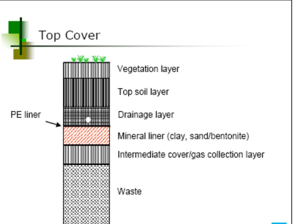
Landfill liners Materials (both natural and manufactured) that are used to line the bottom and below- grade sides of a landfill. They usually consist of layers of compacted clay/or geomembrane, Burnt bricks material designed to prevent migration of landfill leachate and landfill gas.

52
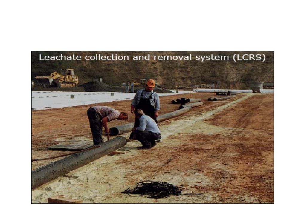
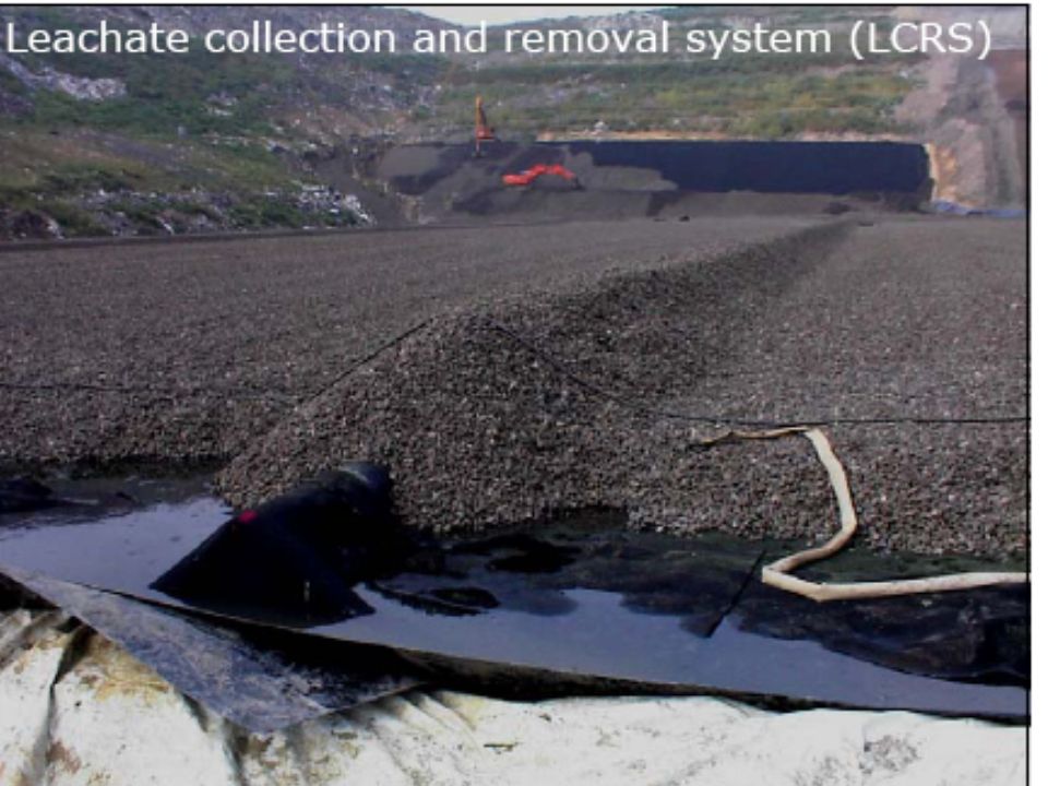
Landfill control facilities Include liners, landfill leachate collection and extraction systems, Landfill gas collection and extraction systems, daily, intermediate and final cover layers, groundwater monitoring wells, weighing bridge,etc.

53
SOME BASIC SHAPES

54
Sanitary MSW Landfill

60
Gas collection and removal system

63
VOLCANO Introduction Volcano: A mountain or hill formed by the accumulation of materials erupted through one or more openings (called volcanic vents) in the earth's surface. The term volcano can also refer to the vents themselves. The volcanoes occur at both above sea level and beneath the sea, Volcanic eruptions in populated regions are a significant threat to people, property, and agriculture (Vulnerability). The danger is mostly from fast-moving, hot flows of explosively erupted materials, falling ash, and highly destructive lava flows and volcanic debris flows (Volcano Hazards). Eruptions, even from volcanoes in unpopulated regions, can eject ash high into the atmosphere, creating drifting volcanic ash clouds that pose a serious hazard to airplanes.
. The danger is mostly from fast-moving, hot flows of explosively erupted materials, falling ash, and highly destructive lava flows and volcanic debris flows (Volcano Hazards). Eruptions, even from volcanoes in unpopulated regions, can eject ash high into the atmosphere, creating drifting volcanic ash clouds that pose a serious hazard to airplanes..")
64
Magma Sources Magmas originate at depths where the temperature is high enough and the pressure is low enough that the rock can melt, wholly or partially. Originate in the upper mantle, at depths between 50 and 250 kilometers (30 and 150 miles) and from the asthenosphere to the surface through fractures in the lithosphere (as, for example, at spreading ridges). In subduction zones, where down-going lithosphere and seafloor sediments are pushed into the warmer, deeper mantle and may be heated enough to melt. The resultant melt, less dense than the surrounding mantle, rises, perhaps all the way to the surface. A magma rising through the crust, in turn, warms the crustal rocks immediately around it and may start them melting as well.
 and from the asthenosphere to the surface through fractures in the lithosphere (as, for example, at spreading ridges). In subduction zones, where down-going lithosphere and seafloor sediments are pushed into the warmer, deeper mantle and may be heated enough to melt. The resultant melt, less dense than the surrounding mantle, rises, perhaps all the way to the surface. A magma rising through the crust, in turn, warms the crustal rocks immediately around it and may start them melting as well..")
65
Composition of Magma The major compositional variables are the proportions of silica (Si0 2 ), Fe, and Mg More Si0 2 -rich magmas are poorer in Fe and Mg, and vice versa (Bowen Rxn series). Magmas also contain dissolved water and gases. Silica-poor, iron-magnesium rich The Si0 2 -poor, Fe and Mg -rich magmas are the course-grained Gabbros and the fine-grained basalt typical of the sea floor and of many volcanoes. The lavas of the sea-floor type are characteristically "thin," or low in viscosity, so they flow very easily. Silica-rich, iron-magnesium poor Si0 2 -rich magmas are more viscous, thicker and stiffer, and flow very sluggishly. The viscous, Si0 2 -rich magmas tend to trap the gases, which may lead, eventually, to an explosive eruption. Rhyolite is the volcanic, fine-grained compositional equivalent of Granite and is derived from a very siliceous melt. Volcanic rock of composition intermediate between rhyolite and basalt is Andesite.

66
Volcano locations Most volcanic activity occurs at; – Close to plate boundaries, and located over subduction zones. – Ring of Fire, is the collection of volcanoes rimming the Pacific Ocean, and is actually a ring of subduction zones. – A few volcanoes are associated with rift zones-for instance, Kilimanjaro and other volcanoes of the East African Rift system. Seafloor Spreading Ridges – Most volcanic rock originates at the seafloor spreading ridges – Spreading ridges spread at the rate of only a few centimeters per year. – Most of this activity is out of sight under the oceans.

67
Individual volcanoes Fissure Eruptions The outpouring of magma at spreading ridges Volcanic Domes Rhyolitic and andesitic lavas, i.e Si0 2 –rich, oozes out at the surface like thick toothpaste from a tube, piling up close to the volcanic vent, Structure is a more compact and steep-sided volcanic dome. Tends to be relatively small in areal extent. Cinder Cones Pop-up magmatic material forming symmetric cone-shaped heaps Composite Volcanoes Volcanoes of different materials at different times. Material may be emition of pyroclastics, and lava, alternately. Built up is in layer-cake fashion are called strato-volcanoes.

68
Hazards related to volcanoes Lava Low silica, highly fluid, low viscosity, mafic minerals, basaltic etc Pyroclastics Pyroclastics-fragments of hot rock and spattering lavas Lahars Pyroclastic materials melts the snow and ice on the mountain, producing a mudflow of melt-water and volcanic ash Nuees Ardentes Pyroclastic outburst, denser-than-air mixture of hot gases and fine ash. Toxic Gases Water vapor and carbon dioxide, carbon monoxide, various sulfur gases, and hydrochloric acid, are actively poisonous etc Steam Explosions (Phreatic eruption) On volcanic islands, large quantities of seawater may seep down into the rock, come close to the hot magma below, turn to steam, and blow up the volcano like an overheated steam boiler. Secondary Effects: Climate A single volcanic eruption can have a global impact on climate.
 On volcanic islands, large quantities of seawater may seep down into the rock, come close to the hot magma below, turn to steam, and blow up the volcano like an overheated steam boiler. Secondary Effects: Climate A single volcanic eruption can have a global impact on climate..")
69
PROBLEMS OF PREDICTING VOLCANIC ERUPTIONS Classification of Volcanoes by Activity In terms of their activity, volcanoes are divided into three categories: active; dormant, or "sleeping"; and extinct, or "dead." Active if it has erupted within recent history. Dormant: inactive for the present but with the potential to become active again. Extinct: Historically, has no recent eruptive history or very unlikely to erupt again. Volcano erupts once every 220 years. 20 % of all volcanoes erupt less than once every 1,000 years, 2 % erupt less than once in 10,000 years. Long quiescence, is no guarantee of extinction.

70
Volcanic Precursors Seismic activity (earthquakes). The rising of a volume of magma and gas up through the lithosphere beneath a volcano puts stress on the rocks leading to seismic activities Increased frequency and intensity of earthquake activity. Sometimes, the shock of a larger earthquake may itself unleash the eruption. Bulging, tilt, or uplift of the volcano's surface is also a warning sign. It often indicates the presence of a rising magma mass, the buildup of gas pressure, or both. Changes in the mix of gases coming out of a volcano may give clues to impending eruptions. Surveys of ground surface temperatures may reveal especially warm areas where magma is particularly close to the surface and about to break through. Animals, which have behaved strangely for some hours or days before the event. Perhaps animals are sensitive to some changes in the earth that scientists have not thought to measure.

71
Top: Schematic volcanic dome Bottom: Dome built in the crater of Mount St. Helens Fissure eruption Shield volcanoes

72
Cinder cone: Left- daytime and Top- nighttime eruptions showing ejection of hot pyroclastics, piling up in a cone shape

73
Lava treesVolcanic ash eruption at night time

74
WATER POLLUTION Introduction Water Pollution is the contamination of water by foreign matter such as micro-organisms, chemicals, and industrial or other wastes, or sewage. Such matter deteriorates the quality of the water and renders it unfit for its intended uses. Point and Non-Pollution Source – Point pollution involves those pollution sources which can be specifically identified, such as factories, refineries, or outfall pipes. – Non-point pollution involves pollution from sources that cannot be precisely identified, such as runoff from agricultural or mining operations or seepage from septic tanks or sewage drain fields.

75
MAJOR POLLUTANTS The major pollutants of water are the following: Sewage and other oxygen-demanding wastes Infectious agents. Plant nutrients that can stimulate the growth of aquatic plants Exotic organic chemicals, e.g. pesticides, industrial products, detergents, and the decomposition products of other organic compounds. Petroleum, especially from oil spills. Inorganic minerals and chemical compounds. Sediments consisting of soil and mineral particles Radioactive substances from such sites.

76
EFFECTS OF WATER POLLUTION Human health issues – Nitrates in drinking water can cause a disease in infants that sometimes results in death. – Cadmium in sludge-derived fertilizer can be absorbed by crops; if ingested in sufficient amounts, the metal can cause an acute diarrhoeal disorder and liver and kidney damage. – Mercury, arsenic, asbestos etc are often describes as carcinogenic. Eutrophication: Lakes/water pools are especially vulnerable to this; – Eutrophication occurs when lake water becomes artificially enriched with nutrients, causing abnormal plant growth. – Run-off of chemical fertilizer from fields may trigger this. Acid rain: Another problem, of growing concern in recent years, is acid rain, which has left many lakes in northern and eastern Europe and north- eastern North America totally devoid of life.

77
SOURCES AND CONTROL 3 major sources of water pollution can be classified as; Municipal, Industrial, and Agricultural.

78
Municipal wastewater Consists of wastewater from homes and commercial establishments. Control: The basic methods of treating municipal wastewater fall into three stages: – primary treatment, including grit removal, screening, grinding, flocculation (aggregation of the solids), and sedimentation; – secondary treatment, which entails oxidation of dissolved organic matter by means of biologically active sludge, which is then filtered off; and – tertiary treatment, in which advanced biological methods of nitrogen removal and chemical and physical methods such as granular filtration and activated carbon absorption are employed.
, and sedimentation; – secondary treatment, which entails oxidation of dissolved organic matter by means of biologically active sludge, which is then filtered off; and – tertiary treatment, in which advanced biological methods of nitrogen removal and chemical and physical methods such as granular filtration and activated carbon absorption are employed..")
79
Industrial wastewater Impacts: depends on; – their collective characteristics, such as biochemical oxygen demand, – amount of suspended solids, and – content of specific inorganic and organic substances. Control: Can take place at three different stages; – the point of generation within the plant; – pretreated for discharge to municipal treatment systems; or – can be treated completely at the plant and either reused or discharged directly into receiving waters.

80
Agriculture wastewater Includes commercial livestock and poultry farming. – Contaminants include both sediment from the erosion of cropland and compounds of phosphorus and nitrogen that partly originate in animal wastes and commercial fertilizers. – Animal wastes are high in oxygen-demanding material, nitrogen, and phosphorus, and they often harbour pathogenic organisms. – Wastes from commercial feeders are contained and disposed of on land; their main threat to natural waters, therefore, is via run- off and leaching. Control may involve; – Settling basins for liquids, – Limited biological treatment in aerobic or anaerobic lagoons, etc.

81
Pollutions of global concern Marine pollution – Wastes that are discharged directly into United States marine waters are estimated conservatively to exceed 45 million tonnes per year. – About 80 % of this amount is waste produced by dredging, 10 % is industrial waste, and 9 % is sewage sludge. Oil spills – Tanker spills are an increasing environmental problem because once oil has spilled, it is virtually impossible to remove or contain it completely. – Small amounts spread rapidly across large areas of water. – Large-scale accidental discharges of liquid petroleum products are an important cause of pollution along shorelines.

82
WATER POLLUTION IN MINING ENVIRONMENT Mining pollution occurs primarily in four forms: Acid Mine Drainage, Heavy Metal Contamination, Processing Chemicals Pollution, Erosion and Sedimentation

83
Acid Mine Drainage (AMD) Acid Mine Drainage, or "AMD," pollution is generated when rock, excavated from an open pit or opened up in an underground mine, which contains sulfide minerals that reacts with water and oxygen to create sulfuric acid. Iron pyrite, "fool's gold," (FeS) is the most common rock type that reacts to form AMD. The acid will leach from the rock as long as its source rock is exposed to air and water and until the sulfides are leached out. – FeS + O 2 == H 2 SO 4 + Fe(III) compound (yellowish slime or yellow boy colouration) Acidophilic bacteria (acidloving), most prominently the species Thiobacillus ferro-oxidans, are triggered into action when acidity falls below a particular level (pH of 4) thus catalyzing the oxidation of iron. AMD severely degrades water quality, killing aquatic life and making water virtually unusable.
 is the most common rock type that reacts to form AMD. The acid will leach from the rock as long as its source rock is exposed to air and water and until the sulfides are leached out. – FeS + O 2 == H 2 SO 4 + Fe(III) compound (yellowish slime or yellow boy colouration) Acidophilic bacteria (acidloving), most prominently the species Thiobacillus ferro-oxidans, are triggered into action when acidity falls below a particular level (pH of 4) thus catalyzing the oxidation of iron. AMD severely degrades water quality, killing aquatic life and making water virtually unusable..")
84
Heavy metal pollution Heavy metal caused when trace metals contained in excavated rock or exposed in an underground mine come in contact with water. Heavy metals found in mining waste may include arsenic, cobalt, copper, cadmium, chromium, gold, iron, lead, silver, and zinc. For example at the Obuasi mine, dominant trace metals are Fe, As, S, Pd, Sb, Cu, Zn, S - Au. As water washes over the rock surface, metals are leached out and carried downstream. Metal leaching is greatly accelerated where acid mine drainage occurs. Heavy metals, even in trace amounts, can be toxic to humans and wildlife. When metals are in dissolved form they are more readily absorbed and accumulated by plant and animal life, and are therefore generally more toxic than when precipitated out or solid. They bio-accumulate in animal tissues and plants are passed to other living things through the food chain.

85
Processing chemicals pollution Processing chemicals pollution is caused when chemical agents used by mining companies to separate the target mineral from the ore (such as cyanide, sulfuric acid, or the liquid metal mercury spill, leak, or leach from the mine site into nearby water bodies. Mercury is a dangerous toxin, and it bio-accumulates through the food chain. However, the mercury amalgamation process usually only recovers about 60 percent of the gold in an ore, Hence inefficient, and extremely dangerous to human health, hence the strict safety and environmental controls on its use. Cyanide, rather than mercury; provides recovery of 97 percent of all the gold in the ores it treats. Cyanide breaks down readily and does not bio-accumulate in organisms but remains an acutely toxic chemical. Cyanide causes death among living organisms by blocking the transport of oxygen across cell walls. Cyanide contamination occurs when protective liners beneath solution ponds at mines break or tear, when cyanide holding ponds overflow or breach after rainstorms, when piping systems carrying cyanide solutions fail, and when too much cyanide solution is used in leaching operations and discharged in tailings. Sulfuric acid contributes to acid mine drainage.

86
Erosion and Sedimentation Mining strips away vegetation, a natural anchor for rock and soil. Explosives and earthmoving machinery fracture and dislodge rock, much of which winds up in waste piles. Road building and the construction further disturb the land. Finely ground tailings are stored in impoundments, as well as ores piled in heaps for leaching with cyanide. When erosion occurs, sediments are carried and transported into streams, lakes, and reservoirs where they accumulate. They act as physical pollutants by changing the light, temperature, and oxygen conditions. Sediments accumulated in streams and river channels, to reduce the capacity of waterways to carry storm water runoff, which may cause flooding, causing even greater environmental impacts. Sedimentation also reduces the storage capacity of reservoirs.

87
TROPICAL WEATHERED ROCKS AND RESIDUAL SOILS Soil is a mixture of mineral and organic matter, water and air. Soil characteristics include texture, structure, color and an identifiable profile or series of definite layers called horizons. Soils generally may be classified as being residual or transported, depending upon the origin of their parent materials. The major processes which reflect the action of climate and vegetation are called laterization, podzolization and calcification. One process alone or in combination with others may be involved in the evolution of any one soil. The zonal soils depend upon the balance among these processes which exist in different parts of the world.

88
Zonal soils Pedalfer soils e.g. Tropical and Subtropical red and yellow soils Grey Brown Podzol Soils Podzol Soils Tundra Soils Pedocal soils e.g Desert soils

89
Tropical and Subtropical red and yellow soils Red or yellow colour Deep A and B horizons Little or no humus (partially-decayed organic matter) A horizon coarse and porous; soil acidic B horizon deeper red and somewhat finer-textured Relatively low inherent fertility (native fertility) Found where there are great amounts of moisture and where temperatures allow year-around soil formation Excessive leaching and eluviations The above soil is typical of tropical rainforest, tropical and semi-deciduous forest, tropical savanna, Mediterranean scrub in tropical mixed deciduous-coniferous forest areas.
 A horizon coarse and porous; soil acidic B horizon deeper red and somewhat finer-textured Relatively low inherent fertility (native fertility) Found where there are great amounts of moisture and where temperatures allow year-around soil formation Excessive leaching and eluviations The above soil is typical of tropical rainforest, tropical and semi-deciduous forest, tropical savanna, Mediterranean scrub in tropical mixed deciduous-coniferous forest areas.")
90
Desert soils Very shallow profile Grayish, only slightly altered parent material closely underlain by calcium nodule zone may be hardpan Very definitely a basic soil Often of high inherent fertility Found in some grasslands; on dry side of Chestnut and Brown soils

91
Characteristics of tropical residual soils (I) Mineralogy; – Minerals are clay-sized particles of quartz, kaolinite, goithite, haematitie, gibbsite and boehmite, in sesquoixide cement. Development of residual soils in the tropics; – Rock weathering in the tropic is rapid and intense due to the prevailing climatic conditions. Factors that affect rock weathering are; – Parent rock, rainfall, topography, vegetation geomorphology and drainage. Key process is lateralization, where; – Residual soils undergo fabric and compositional changes to form wear- surface deposits rich in sesquioxides. Domain of activity is; – Gentle relief, with restricted erosion, where the laterite is often capped by a ferruginous crust of hardpan. Texture; – Reddish laterites that is porous to concretional.

92
Characteristics of tropical residual soils (II) Engineering properties; – Hardens on exposure due to dehydration. They therefore provide good bearing stratum for foundations as well as supporting high and steep stopes. Could also be used in road pavement construction. – Geochemical characterization involves a full understanding of the: groundwater condition, position, mineralogy, and fabric of the rock or weathering grade, as well as the degree of post-formational changes in the soil such as aggregation or desiccation. To characterize weathering profile; – Distinguish between residual soil and saprolite (soil-like but retaining original rock fabric, in order to decide an the relevant rock or soil mechanics test to adopt.

93
Weathering profile: – A typical profile, as in Ghana consists of Upper horizon of residual soil, predominantly lateritic, with 100% weathering quality. – A middle horizon of moderately to completely weathered rock (saprolite). This zone can be sub- divided into 3 zones, according to the degree of weathering (10-35%, 35-75%, and > 75%). – The lower horizon of fresh to slightly weathered rock (bedrock). Can be sub-divided into two zones of weathering characteristic as > 10% and 10%
. This zone can be sub- divided into 3 zones, according to the degree of weathering (10-35%, 35-75%, and > 75%). – The lower horizon of fresh to slightly weathered rock (bedrock). Can be sub-divided into two zones of weathering characteristic as > 10% and 10%.")
94
SOIL PROFILE

95
FLOODS Floods are generally the result of heavy rains, rapidly melting snows, or in very rare instances dam breakage. They also occur as a consequence of other disasters, for example a tsunami after an earthquake, or a result of catastrophic rains that accompany a tropical storm. They can be classified into coastal floods, most of which are associated with storm surge and river channel floods. A flood is said to occur when a body of water overflows land which is not normally submerged. The size of modified stream channel is directly related to the quantity of water that it usually carries.

96
CONSEQUENCES OF FLOODING ON A COMMUNITY Few deaths, except in the event of flash-flood or by the collapse of a river dike. Effects on agriculture; both negative and positive Destruction of infrastructure Floods destroy land by river bank erosion and can create new lands by the deposition of fertile river silt. Effect on livestock and aquaculture. Surcharging of any sewerage system that there may be, spreading raw sewage to all the flooded area. Health risk, or Health care and public hygiene affected Saline flooding, from sea water.

97
Principal Flood Hazards Hazards – Loss of lives, both humans and livestock – Loss of property, including farm produce and infrastructure – Loss of farmland – Famine – Diseases – Poverty – Burden on local administrative authorities etc Mitigation ? – An improvement in the drainage systems of the vulnerable cities and towns – Strict compliance to building codes – Education and sensitization

98
Location of building projects Buildings in certain locations are more likely to be affected in particular ways for example those in, or approximate to, the following: Flood plains Steep river banks Upstream of restrictions (e.g. bridges and culverts) Normally dry river beds
 Normally dry river beds.")
99
Factors that Promote Flooding/Cause and effect The surface geology and topography of an area. Other important factors include the following issues: Permeability and porosity Rock fracture Mineralogy (clay-rich seals the surface against infiltration). Elevation in topography Climatological factors (excess precipitation overrules natural infiltration)
. Elevation in topography Climatological factors (excess precipitation overrules natural infiltration).")
100
MASS MOVEMENTS Mass movement is the general term for a variety of processes by which large masses of earth are moved downslope under the influence of gravity. Mass movement depends on geological parameters (including discontinuities and lithological properties), hydrogeological conditions and geomorphological features of the slope. Factors that trigger mass movement – The addition of water – Overloading of a slopes – River undercutting a slope – Shocks or the vibrations of passing traffic. – The removal of vegetation Methods used to control mass movement – Draining excess moisture from the soil – Retaining walls, with numerous drains, – Keeping native vegetation on slopes – Contour plowing on farm fields with slopes Mass Movements in Ghana – Spectacular landslides have been reported in such highland areas as the Akwapim Range, Kwahu Plateau, Mampong Scarp and Gamabaga Scarp, where rockfalls have particularly resulted in some loss of human lives and the destruction of farmlands, vegetation and infrastructural facilities. Major roadcuts also potential sites for minor occurrences. – Creep has also contributed to some foundation failures particularly in Accra where active faults are widespread.
, hydrogeological conditions and geomorphological features of the slope. Factors that trigger mass movement – The addition of water – Overloading of a slopes – River undercutting a slope – Shocks or the vibrations of passing traffic. – The removal of vegetation Methods used to control mass movement – Draining excess moisture from the soil – Retaining walls, with numerous drains, – Keeping native vegetation on slopes – Contour plowing on farm fields with slopes Mass Movements in Ghana – Spectacular landslides have been reported in such highland areas as the Akwapim Range, Kwahu Plateau, Mampong Scarp and Gamabaga Scarp, where rockfalls have particularly resulted in some loss of human lives and the destruction of farmlands, vegetation and infrastructural facilities. Major roadcuts also potential sites for minor occurrences. – Creep has also contributed to some foundation failures particularly in Accra where active faults are widespread..")
101
FIGURE 1

102
SOLID WASTE AND LANDFILL MANAGEMENT WASTE TYPES (i) Waste generated within the environment can be categorized into two namely; – General waste – Hazardous waste – General/Inert Waste Rubble Domestic waste Commercial waste Dry industrial waste – Hazardous and Toxic or Contaminated Waste The most dangerous aspect of the waste stream we have described is that it often contains highly toxic and hazardous materials
 Waste generated within the environment can be categorized into two namely; – General waste – Hazardous waste – General/Inert Waste Rubble Domestic waste Commercial waste Dry industrial waste – Hazardous and Toxic or Contaminated Waste The most dangerous aspect of the waste stream we have described is that it often contains highly toxic and hazardous materials")
103
WASTE TYPES (ii) What is hazardous waste? Hazardous waste is any discarded material, liquid or solid, that contains substances known to be; – Fatal to humans or laboratory animals in low doses, – Toxic or carcinogenic – Ignitable with a flash point less than 60 degrees – Corrosive – Explosive or highly reactive

104
WASTE TYPES (iii) Inorganic Waste – Acid and alkalis – Heavy metal sludge & solutions – Waste with appreciable levels of fibrous asbestos. Oily Waste – Oily waste is generated primarily from the processing, storage and use of mineral oils and the servicing of machinery. Organic Waste – Paints and resin

105
WASTE TYPES (iv) Explosive Waste – Old recovered explosives Medical Waste – Biological / Medical – Dressing materials e.g. cotton wool and gauze – Used syringes – Used needles – Used sharp ends – Expired drugs – Sewage from cleaning and laundry services – Domestic waste from kitchen etc

106
GENERAL/INERT WASTE DISPOSAL Waste storage sites Open Dumps Ocean Dumping Landfills Exporting Waste Incineration and Resource Recovery

107
SHRINKING THE WASTE STREAM Some of the options for waste shrinking are; Recycling Reuse and Reduction Simply referred to as the 3 Rs

108
Recycling The term recycling has two meanings in common usage. It is either: Reusing or Reprocessing.

109
Relevance of Recycling Benefits to derive from Recycling Creating Incentives for Recycling Composting Energy from Waste Reuse Producing Less Waste

110
Benefits of Recycling It saves money, energy, raw materials, and land space, while also reducing pollution. It encourages individual awareness and responsibility for the refuse produced. It could cut our waste volumes drastically It lowers demands for raw resources Reduces litter

111
8 things that can be done to reduce waste Buy foods that come with less packaging; shop at farmers’ markets or co- ops, using own containers. Take your own washable refillable beverage container to meetings or convenience stores. When you have a choice at the grocery store between plastic, glass, or metal containers for the same food, buy the reusable or easier-to-recycle glass or metal. When buying plastic products, pay a few cents extra for environmentally degradable varieties. Separate your cans, bottles, papers, and plastics for recycling. Wash and reuse bottles, aluminum foil, plastic bags, etc., for your personal use. Compost yard and garden wastes, leaves, and grass clippings. Write to your senators and representatives and urge them to vote for container deposits, recycling, and safe incinerators or landfills.

112
HAZARDOUS WASTE DISPOSAL Most hazardous waste is recycled, converted to non-hazardous forms, stored, or otherwise disposed of on site by the generators (chemical companies, petroleum refiners, and other large industrial facilities), so that it doesn’t become a public problem.
, so that it doesn’t become a public problem.")
113
Sites Superfund Sites Hazardous Landfill and Dumps Waste Lagoons and Injection Wells Warehousing and Illegal Dumping Options for Hazardous Waste Management Produce Less Waste Convert to Less Hazardous Substances Store Permanently – Retrievable storage: – Secure Landfills:

Similar presentations