Download presentation
Presentation is loading. Please wait.

1
Flight Navigation Richard Jessop, 2Lt, CAP Asst AE Officer

2
Tonight’s Mission Squadron Commander states that we have the largest contingent of cadets in COWG However, we are only the second largest squadron in terms of total numbers There has been an competitive and persistent troop build-up at Thompson Valley Composite Squadron (TVCS) Therefore, our mission is to apply the power and flexibility of aviation and plan a bombing run on TVCS HQ in Ft. Collins, CO.

3
Approach We will have several smaller training missions leading up to the final mission Step 1: Learn basic techniques of aerial navigation Step 2: Learn advanced techniques of aerial navigation including the use of navigation instruments Step 3: Apply all techniques in a flight simulation environment

4
Basic Techniques of Aerial Navigation What do we need to know and do in order to fly to TVCS? 1.Where are we? 2.Where are they? 3.How do we get there? 4.Record all information on a Flight Planning Worksheet Get the appropriate map Establish the course Measure the distance Calculate time of flight Determine fuel requirements

5
Aeronautical Maps There are 3 major types of aeronautical maps that are based on map scale and used for VFR flight 1.VFR Terminal Area Chart 2.(Standard) Sectional Aeronautical Chart 3.World Aeronautical Chart What are the scales of each?
 Sectional Aeronautical Chart 3.World Aeronautical Chart What are the scales of each")
6
A Note about Scale What does 1:500,000 mean? –1 unit of measure on the map = 500,000 units in the real world –Why 500,000? Intended for metric users 1 cm = 500,000 cm = ? meters = ? kilometers 1 in = 500,000 in = ? statute miles = ? nautical miles

7
Map Legend Symbology –Important to know the information on the legend –The legend does not contain all of the symbols found in the map Terrain Information –Shown by color and shading –Shown by contours –Shown by spot elevations –Each grid contains a Maximum Elevation Figure (MEF) in hundreds of feet
 in hundreds of feet")
8
Establishing the Course Find your two points (the “from” point and the “to” point) Enter the names in your worksheet Line the ruler up on the points. –For airports, go to the “center of mass” Place the protractor on the ruler Slide the protractor on the ruler until it’s center mark lines up with a line of longitude

9
Establishing the Course (cont.) Measure the angle –If the course is to the east, the angle better be around 90°. –If the course is to the west, the angle better be around 270°. How do we measure this with a 180° protractor? –Measure the angle as if towards the east and add 180° –If the course is north or south will be covered in the advanced techniques lesson. We have established the True Course (TC) Enter the information in your worksheet
 Enter the information in your worksheet.")
10
Correcting for Magnetic Variation On the sectional, look for the isogonic/agonic line What is its value? Enter it on your worksheet Add or subtract the value from TC The result is the Magnetic Course (MC) Enter the result on your worksheet
 Enter the result on your worksheet.")
11
Correcting for Wind This will be covered in the advanced techniques lesson For now, assume calm winds. Enter 0, 0 for the wind speed and direction on your worksheet Enter 0 for the Wind Correction Angle (WCA) When you correct MC for wind, the result is called the Magnetic Heading (MH) Enter the MH on your worksheet
 When you correct MC for wind, the result is called the Magnetic Heading (MH) Enter the MH on your worksheet.")
12
Measuring the Distance Take your ruler and measure the distance between your two points Multiply the value by the scale This is the distance in inches. Convert to feet, then convert to nautical miles. –Hint: Divide by 12 to get feet –Hint: Divide again by 6076 to get nautical miles Enter the value on your worksheet

13
Calculating the Time of Flight D = R x T (distance = rate times time) We have the distance What is the rate? –Since we will be flying the much-feared Cessna B-182, the true airspeed (TAS) will be 90 knots –Enter the TAS on your worksheet Rearrange the distance equation to isolate time –T = D / R Compute the time –What are the units of time here? –Convert to minutes Hint: Multiply by 60 to get minutes Enter the leg time on your worksheet
 will be 90 knots –Enter the TAS on your worksheet Rearrange the distance equation to isolate time –T = D / R Compute the time –What are the units of time here. –Convert to minutes Hint: Multiply by 60 to get minutes Enter the leg time on your worksheet.")
14
Determine Fuel Requirements This will be covered in the advanced techniques lesson

15
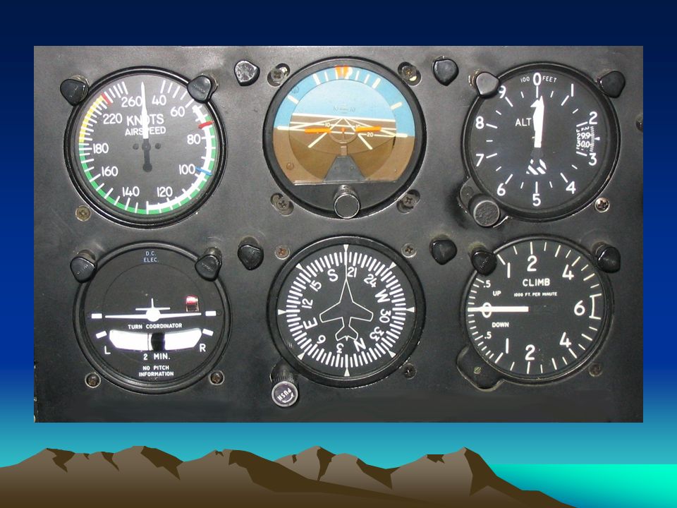
What do We do with the Information? What was our mission? What flight instrument(s) will we use? –Heading Indicator (Directional Gyro or DG) –Airspeed Indicator –Stopwatch
 will we use. –Heading Indicator (Directional Gyro or DG) –Airspeed Indicator –Stopwatch.")
17
Questions? A lot of complex material! We will review the material again next time If possible, we will enter one cadet’s information into the flight simulator and see how accurate the work was Bottom line: Do well in the basics in school! –Geometry, Basic Algebra, Arithmetic

Similar presentations

 Step 2Align Wind Direction with True Index Step 3Place Wind.>")


 O-0205 LOCATE A POINT ON A MAP USING THE CAP GRID SYSTEM (S) O-2003 GRID.>")


