Download presentation
Presentation is loading. Please wait.

1
Seasonal Update for Autumn Dale Grey Seasonal Risk Agronomist Bendigo

2
Coupled global circulation models Ocean model + atmosphere model

3
Anomaly Map

4
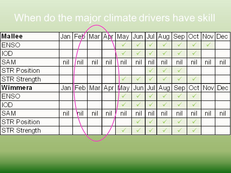
When do the major climate drivers have skill

6
Does winning the pre season comp in Feb tell you anything about finals contention? In June-July, greater confidence that your team is going OK, or not. Come September its almost assured.

7
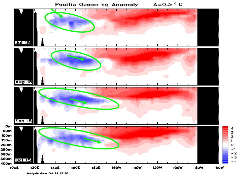
……….strong reversal! And again Ecuador PNG

9
Central reversal El Niño switch off mechanism. Loss of heat to depth Confused Ecuador PNG

10
Ecuador PNG Potential 2016 La Niña Plenty of random weather to happen in the tropics before it might happen, if at all.

11
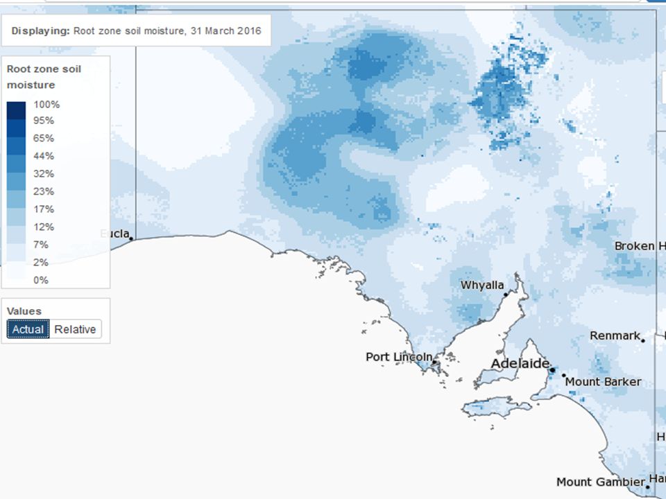
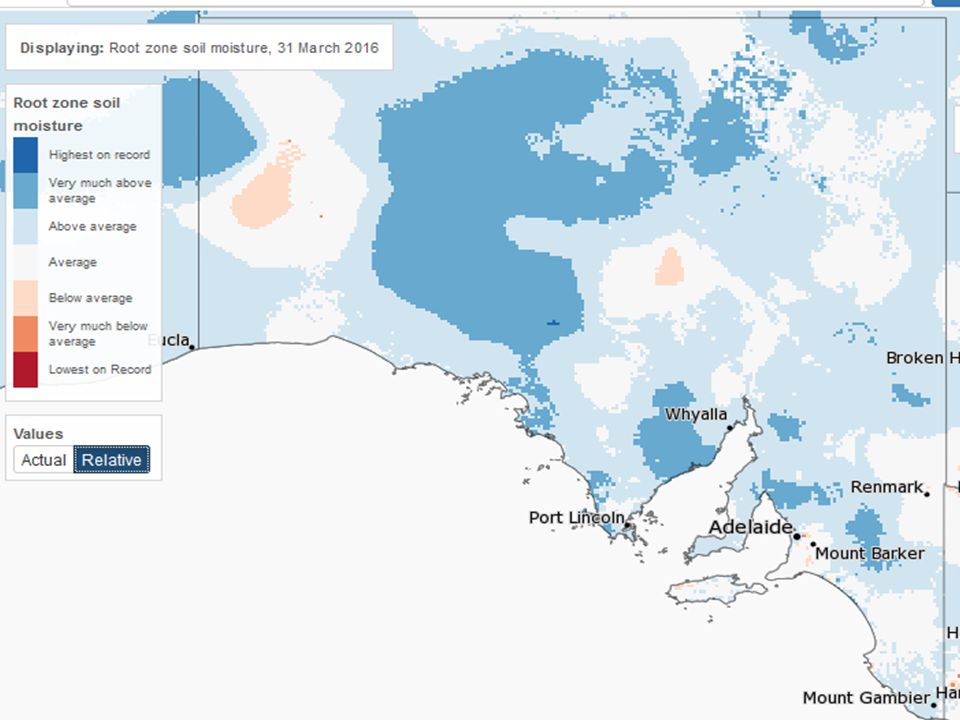
Currently the Nino 3 and 3.4 areas of the Pacific are slowly cooling at +1.39C, +1.35 o C, above El Niño thresholds of 0.8 o C, but at this time of the year it’s a case of big deal! 31 st March 2016

12
The DMI measurement of the Indian Ocean Dipole is +0.03 neutral, at this time of the year rarely doing much. 31 st March 2016

13
Timor, Coral and Arafura Seas still warmer, that’s good as a moisture source. Whole Indian Ocean warmest on record, record evaporation going somewhere.

14
In the last 30 days Cloud at the International Date Line was abundant = El Niño. Lack of cloud to the north of Australia, affecting the northern wet season. But slowly improving. Heaps of cloud over SA, Indian Ocean connection starting to pick up again slowly. cloudyclear

15
Southern Oscillation Index = SOI = difference in air pressure (Tahiti – Darwin) The SOI has ants in its pants -4.7 and rising. The pattern of high and low pressure around the Equator indicates a neutral status. Slightly higher pressure at both Darwin and Tahiti = neutral. But not worth watching at this time of the year.

16
Last 30 days Air Pressure H Source = NOAA The Sub Tropical Ridge latitude is in a Summer position, but should be heading north through Autumn. The trough line was in the Tasman Sea.

17
Last 30 days Air Pressure Anomaly Pressure has been lower over SA. Was a wetter March Darwin pressure higher, Tahiti higher = SOI neutral Be good if pressure returned to normal over northern Australia Source = NOAA

18
Lameroo

19
Kadina

20
Minnipa

21
Autumn Pacific Ocean-Mixed probably slightly warmer Indian Ocean-Warm Rainfall-Average/slightly wetter Temperature-Slightly warmer

22
Winter Pacific Ocean-Mixed, probably slightly cooler Indian Ocean-Slightly warm/warm, possible -IOD Rainfall-Slightly wetter Temperature-Mixed

23
Historically after an El Nino 40% La Nina, 48% Neutral, 12% El Nino Historically, GSR after an El Nino, 75% averagish or better No insight as to the timing of the break, anywhere from Apr–June now. Many models saw a change in pattern towards more rainfall in April, but this is now drifting into May.

24
History says chances of reasonable rain are good. Models say warm Indian Ocean for some time. Models are supportive of some optimism but at a time of poor skill. La Nina’s of late haven’t fired for spring. Springs are warmer. Pressure pattern in autumn and winter have been causing issues most years, a greater issue in the east of SA

25
Subscribe to “The Break “ newsletters, Email the.break@ecodev.vic.gov.a u Or Google “The Break” DEDJTR Thank you Diani Beach, Southern Kenya Sikuai Island, West Sumatra

26
Worldwide effects of La Niña and El Niño El NiñoLa Niña El Niño La Niña

Similar presentations


 is an index derived from North Pacific sea surface temperature anomalies and it has a high correlation to.>")


 - El Nino (ocean) - change in equatorial Pacific circulation - produces global climate.>")


>")