Download presentation
Presentation is loading. Please wait.

1
Data compression – For image archiving (satellite data) – For image transfer over internet
 – For image transfer over internet")
2
6.86 MB 15.2 MB Data compression

3
281 kb 673 kb Data compression

4
– Run-length codes Ex. # 1 Ex. # 2 Data compression

5
– Quadtree A quadtree recursively subdivides a plane into 4 quadrants If area is homogeneous, subdividing stops If the quadrant is heterogeneous with respect to this attribute, further subdivision occurs And so on, and so on, until….. Data compression

6
– Quadtree Data compression

7
– Quadtree Data compression 256 pixels down to to 80

8
8 2304 vs. 160 (or so); run on polygon, not line Data compression – Quadtree
; run on polygon, not line Data compression – Quadtree")
9
9 http://www.izarc.org/

10
NEXT: REMOTE SENSING BASICS 10

11
What is remote sensing? Collecting and interpreting information about a target without being in physical contact. ________ _______ is the medium of interaction. NOTE: We are not focusing on seismic or sonic remote sensing.

12
Energy from the sun travels to Earth through space as electromagnetic radiation The range of electromagnetic radiation is known as the electromagnetic spectrum radiation source

13
Gamma rays<0.03 nm X-rays0.03 – 300 nm UV radiation0.30 – 0.38 μm Visible light0.38 – 0.72 μm Infrared Near-infrared0.72 – 1.30 μm Mid-infrared1.30 – 3.00 μm Far-infrared7.00 – 1,000 μm (1 mm) Microwave1 mm – 30 cm Radio ≥ 30 cm Image from: John R. Jensen. 2007. Introduction to Remote Sensing, 2nd Edition. NJ: Pearson Prentice Hall.

14
Terms: Target Platform Sensor Designed to collect visible, IR, thermal... Instruments sense photons received at different wavelengths.

15
GOES 13 (East) GOES 15 (West) Geostationary Height = 22,237 miles Speed = 0 mph Orbital period = 24 hrs Polar orbiting Height = 438 miles Speed = 16,800 mph Orbital period = 99 min Landsat 7
 GOES 15 (West) Geostationary Height = 22,237 miles Speed = 0 mph Orbital period = 24 hrs Polar orbiting Height = 438 miles Speed = 16,800 mph Orbital period = 99 min Landsat 7")
16
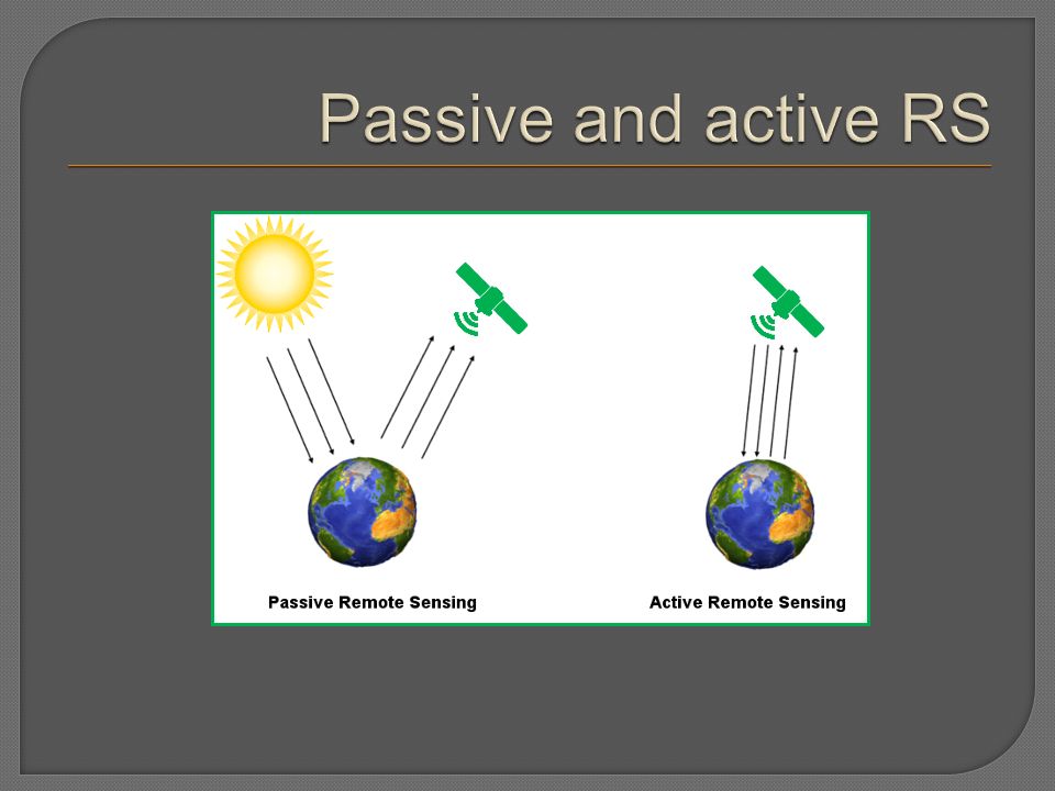
Passive RS: Uses natural energy Either reflected sunlight or emitted thermal or microwave radiation. Active RS: Platform generates own energy Transmitted toward Earth, interacts with surface, reflects back toward sensor.

18
Landsat 7: 4, 3 (Las Vegas, NV area)Landsat TM: 4, 3, 2 (Rome, GA area)
Landsat TM: 4, 3, 2 (Rome, GA area)")
19
Interferometric Synthetic Aperture Radar Mojave Desert, CA (National Training Center)
")
20
Spatial Spectral Radiometric Temporal

21
Reflectivity.20.40.60.80 1.0 m Visible Near IR Grass Concrete Maple Pine Asphalt High Low Water R B G

22
Normalized Difference Vegetation Index (NDVI) Healthy chlorophyll pigments… ABSORB red (VISIBLE) REFLECT near infrared (NIR) Unhealthy chlorophyll pigments -- stressed, diseased, yellowed, dead… REFLECT MORE visible REFLECT LESS near infrared (NIR) Band 4 (NIR) Band 3 (red) Large value means healthy
 Healthy chlorophyll pigments… ABSORB red (VISIBLE) REFLECT near infrared (NIR) Unhealthy chlorophyll pigments -- stressed, diseased, yellowed, dead… REFLECT MORE visible REFLECT LESS near infrared (NIR) Band 4 (NIR) Band 3 (red) Large value means healthy")
23
Earth systems science Weather, climate, SST, dust, ash, geology Natural resource management Agriculture, forestry, wildfires, fisheries, wildlife Social sciences Land use/cover change, deforestation, flood plain mapping, urbanization, impervious surface mapping, archaeology, epidemiology, demography, pollution, urban heat islands, spying, before / after disasters LOOK AT ALL OF THESE NASA MISSIONS: http://www.nasa.gov/missions/current/index.html http://www.nasa.gov/missions/current/index.html

25
NOVA Landsat archaeology video - 14 min. http://www.pbs.org/wgbh/nova/ancient/maya.html

Similar presentations


 Spectrum.>")


 The four resolutions Image Classification Incorporation.>")