Download presentation
Presentation is loading. Please wait.

1
Precipitation-Type Forecasting The Top Down Approach Winter Weather Seminar October 28, 2008 Mike July

2
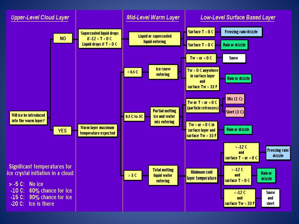
● Objectives: 1) trace hydrometeor from its source (aloft) to the surface 2) determine its final precipitation type(s) LayerAir Mass Impact on Hydrometeor Ice Producing Layercold, midlevel air mass ice crystal nucleation/growth Warm Layer elevated, warm tropical air mass warming/melting Cold Surface Layer surface arctic or modified air mass refreezing/contact freezing ● Depth of cloud layer also important (will examine later) What precipitation type is falling in this example? ►►►► ← Three critical layers Review of the Top-Down Method

3
Purpose - diagnose whether or not significant numbers of ice crystals are present in a cloud. ● Quantity of ice crystals is a function of the cloud temperature - Colder is better. ● Operationally -10°C is a good cutoff point but -12C is the key temperature (70% chance of ice being introduced into a cloud via ice nuclei (IN) activation.) This layer needs to be fairly moist, preferably near saturation. Potential presence of ice crystal initiation in clouds based on temperature Temperature (°C)Potential presence of ice initiation 0no initiation -4no initiation -1060% chance of initiation and presence of ice -1270% chance of initiation and presence of ice -1590% chance of initiation and presence of ice -20100% chance of initiation and presence of ice The Ice Producing Layer
 activation.) This layer needs to be fairly moist, preferably near saturation. Potential presence of ice crystal initiation in clouds based on temperature Temperature (°C)Potential presence of ice initiation 0no initiation -4no initiation -1060% chance of initiation and presence of ice -1270% chance of initiation and presence of ice -1590% chance of initiation and presence of ice % chance of initiation and presence of ice The Ice Producing Layer.")
4
● Defined as a layer with temperature > 0ºC (usually caused by an advancing warm front…….could it be our old friend warm air advection ) ?) ● Rauber et al. (2001) looked at 820 soundings east of the Rocky Mountains. Found a high correlation between the depth of warm layers and the layer maximum temperature. ● As the depth of the warm layer increases so does the maximum temperature. (relationship is nearly linear) ● We will focus on the warm layer maximum temperature as it is easier to assess in the operational setting. Critical warm layer max temperatures for determining precipitation type at the surface (T ≤ 0°C) are given in the figure below (Baumgardt 1999) Warm layer maximum temperature (ºC) Precipitation type with ice introduced Precipitation type without ice introduced < 0.5Snowfreezing rain/drizzle 0.5 to 3 Snow/sleet mix (1 ° C) to sleet (3 ° C) freezing rain/drizzle > 3freezing rain/drizzle The Elevated Warm Layer
 looked at 820 soundings east of the Rocky Mountains. Found a high correlation between the depth of warm layers and the layer maximum temperature. ● As the depth of the warm layer increases so does the maximum temperature. (relationship is nearly linear) ● We will focus on the warm layer maximum temperature as it is easier to assess in the operational setting. Critical warm layer max temperatures for determining precipitation type at the surface (T ≤ 0°C) are given in the figure below (Baumgardt 1999) Warm layer maximum temperature (ºC) Precipitation type with ice introduced Precipitation type without ice introduced < 0.5Snowfreezing rain/drizzle 0.5 to 3 Snow/sleet mix (1 ° C) to sleet (3 ° C) freezing rain/drizzle > 3freezing rain/drizzle The Elevated Warm Layer.")
5
Introducing ice crystals from above the warm layer, here are some possibilities:

6
Some key points to keep in mind for elevated warm layers: ● Maximum temperature ≤ 0.5°C…….will not melt the snow/ice falling into it. Thus, no phase change and ice crystals will survive the warm layer. ● Maximum temperature between 0.5 and 3°C…….the snow/ice will not melt completely. Many or all of the partially frozen hydrometeors will refreeze in the cold surface layer below. → Temperatures closer to 3ºC, the resulting precipitation will more likely be sleet. → Temperatures in the 1-2ºC range, a mix of snow and sleet is more likely. ● Maximum temperature > 3°C……..snow/ice completely melts. → if surface temperature is > 0ºC = rain → if surface temperature is ≤ 0°C = freezing rain/drizzle ● If no ice is present in the cloud, the warm rain process dominates. → surface temperature ≤ 0°C = freezing drizzle or possibly freezing rain → surface temperature > 0°C = rain or drizzle

7
Very Tricky….need to examine: Depth, minimum temperature, and the surface temperature Melt incoming hydrometeor - surface air temp ≥ 0°C? (objects?) - T w > 1°C for ~1000ft will likely melt ice; so rain is likely Freeze/Refreeze incoming hydrometeor - surface air temp < 0°C? → FZRA/FZDZ - if near surface cold layer is cold and deep enough, IN may be introduced to the supercooled drops → PL (A general rule of thumb for ice pellet formation is if the layer is deeper than 750 m and -6ºC or colder. ) Minimum surface layer temperature < -10°C yields ice introduction from supercooled drops → SN?PL? The Near Surface Cold Layer Operational Complications Air temperature is below freezing, terrestrial surface above freezing before arrival of a cold air mass, surface temperatures may not be cold enough to freeze water on contact. Consider this point when dealing with the first cold storm of the fall season or after a period of above-freezing temperatures.
 - T w > 1°C for ~1000ft will likely melt ice; so rain is likely Freeze/Refreeze incoming hydrometeor - surface air temp < 0°C. → FZRA/FZDZ - if near surface cold layer is cold and deep enough, IN may be introduced to the supercooled drops → PL (A general rule of thumb for ice pellet formation is if the layer is deeper than 750 m and -6ºC or colder. ) Minimum surface layer temperature < -10°C yields ice introduction from supercooled drops → SN PL. The Near Surface Cold Layer Operational Complications Air temperature is below freezing, terrestrial surface above freezing before arrival of a cold air mass, surface temperatures may not be cold enough to freeze water on contact. Consider this point when dealing with the first cold storm of the fall season or after a period of above-freezing temperatures..")
8
Other Considerations (extremely rare) Consider a situation where ice crystals are initially not present in the cloud. If the minimum temperature in a cold ground- based layer is cold enough and the layer is deep enough, IN may be activated within this layer producing ice crystals. Supercooled liquid drops falling into this layer can collide with these ice crystals and freeze, resulting in ice pellets. Research suggests that a sub-freezing layer with a depth deeper than 750 m and a minimum temperature of -6ºC or colder is required for this scenario. Operationally this has rarely been seen.

9
A cloud-top temperature warmer than -10°C, favors drizzle or freezing drizzle formed through the collision and coalescence process. Seeder-Feeder Process: ice crystals produced in a higher colder cloud (possibly from elevated convection) falls into lower “warmer” layer and seed the super-cooled water droplets. Convective cells or bands pass over the lower cloud layer and produce snow. After they exit freezing drizzle returns. Maximum separation of the two cloud layers for the process to be effective is about 1500m (~5000ft). Elevated Precipitation-Producing Processes
 falls into lower warmer layer and seed the super-cooled water droplets. Convective cells or bands pass over the lower cloud layer and produce snow. After they exit freezing drizzle returns. Maximum separation of the two cloud layers for the process to be effective is about 1500m (~5000ft). Elevated Precipitation-Producing Processes.")
10
Unsaturated Layers and Wet-Bulb Temperatures Wet-bulb temperature (T w ) is very useful in helping to assess precipitation type because it can yield information about temperature tendency once hydrometeors begin to fall and encounter varying environmental temperatures. When a hydrometeor falls into an unsaturated environment, it will begin to evaporate if it's liquid water, or it will sublimate (solid to vapor) if it's frozen. It can also melt if the temperature is > 0ºC. In all of these cases, thermal energy is going from the environment to the hydrometeor to change the phase. This lowers the temperature of the surrounding environment. Simultaneously, water in the vapor form is also being added to the surrounding environment, thus the dewpoint rises. This results in the temperature cooling and the dewpoint rising, both approaching the wet-bulb temperature, and often continuing until saturation is reached.
 if it s frozen. It can also melt if the temperature is > 0ºC. In all of these cases, thermal energy is going from the environment to the hydrometeor to change the phase. This lowers the temperature of the surrounding environment. Simultaneously, water in the vapor form is also being added to the surrounding environment, thus the dewpoint rises. This results in the temperature cooling and the dewpoint rising, both approaching the wet-bulb temperature, and often continuing until saturation is reached..")
11
Unsaturated Layers and Wet-Bulb Temperatures When a hydrometeor falls into an unsaturated environment, it will begin to evaporate or sublimate (virga?)….or melt if T > 0 ° C. The T w is very useful in helping assess this process. Bufkit is an excellent tool to display/evaluate T w. In all of these cases, thermal energy is going from the environment to the hydrometeor to change the phase. This lowers the temperature of the surrounding environment. Simultaneously, water in the vapor form is also being added to the surrounding environment, thus the dewpoint rises. This results in the temperature cooling and the dewpoint rising, both approaching the wet- bulb temperature, and often continuing until saturation is reached.

12
Factors Affecting Precipitation Type ► Adiabatic Effects ► Thermal advection: warm advection is occurring, but usually lift is as well which produces adiabatic cooling; if ascent is strong, can counteract warm advection resulting in no net warming or even cooling (models can show this); synoptic scale advections are important when not overwhelmed by diabatic effects ► Forcing mechanisms can effect precipitation types ► Jet streak circulations: complements/intensifies isentropic lift in right entrance and left exit regions of jet streaks ► Frontogenesis: locally strengthens lift resulting in banded precipitation, especially near elevated baroclinic zones
; synoptic scale advections are important when not overwhelmed by diabatic effects ► Forcing mechanisms can effect precipitation types ► Jet streak circulations: complements/intensifies isentropic lift in right entrance and left exit regions of jet streaks ► Frontogenesis: locally strengthens lift resulting in banded precipitation, especially near elevated baroclinic zones")
13
Rule of Thumb for Wet Bulb Freezing Height (m) > 1500 mSnow rare 700 - 1500 mSnow possible/likely < 700 mSnow usually occurs Wet-Bulb Freezing Height The probability of precipitation reaching the ground as snow, as opposed to rain, is related to the wet-bulb freezing height as indicated in the table. Unsaturated Layers and Wet-Bulb Temperatures (cont’d) In areas of cloud separated from the surface, some hydrometeors may fall through surface-based dry layers to reach the ground. It is not uncommon for these "dry layers" to exist aloft as well—between two saturated cloud layers. When precipitation falls through the dry, unsaturated layers, the ice/liquid begins to sublime/evaporate. The environmental temperature will begin to cool through evaporation and the dewpoint will rise, with both approaching the wet-bulb temperature. If snowflakes or ice crystals fall into a layer with, for example., T w = -1ºC, T = 5ºC and T d = -5ºC, the particles will begin to melt/evaporate/sublime; thus the temperature will begin to decrease. One study (Penn 1957) suggests this cooling of the environment via evaporation and melting (diabatic processes) can be on the order of 5 to 10ºC per hour. Once the layer is saturated and T = T w = T d = -1ºC, the frozen particles subsequently falling into the layer will remain frozen through the layer. In this scenario, if the initially dry layer is surface-based, virga would occur initially; then the precipitation type would likely progress from rain to snow after the layer becomes saturated and cooler (T w = T = T d = -1ºC). Unsaturated Layers and Wet-Bulb Temperatures (cont’d) In areas of cloud separated from the surface, some hydrometeors may fall through surface-based dry layers to reach the ground. It is not uncommon for these "dry layers" to exist aloft as well—between two saturated cloud layers. When precipitation falls through the dry, unsaturated layers, the ice/liquid begins to sublime/evaporate. The environmental temperature will begin to cool through evaporation and the dewpoint will rise, with both approaching the wet-bulb temperature. If snowflakes or ice crystals fall into a layer with, for example., T w = -1ºC, T = 5ºC and T d = -5ºC, the particles will begin to melt/evaporate/sublime; thus the temperature will begin to decrease. One study (Penn 1957) suggests this cooling of the environment via evaporation and melting (diabatic processes) can be on the order of 5 to 10ºC per hour. Once the layer is saturated and T = T w = T d = -1ºC, the frozen particles subsequently falling into the layer will remain frozen through the layer. In this scenario, if the initially dry layer is surface-based, virga would occur initially; then the precipitation type would likely progress from rain to snow after the layer becomes saturated and cooler (T w = T = T d = -1ºC).
 In areas of cloud separated from the surface, some hydrometeors may fall through surface-based dry layers to reach the ground. It is not uncommon for these dry layers to exist aloft as well—between two saturated cloud layers. When precipitation falls through the dry, unsaturated layers, the ice/liquid begins to sublime/evaporate. The environmental temperature will begin to cool through evaporation and the dewpoint will rise, with both approaching the wet-bulb temperature. If snowflakes or ice crystals fall into a layer with, for example., T w = -1ºC, T = 5ºC and T d = -5ºC, the particles will begin to melt/evaporate/sublime; thus the temperature will begin to decrease. One study (Penn 1957) suggests this cooling of the environment via evaporation and melting (diabatic processes) can be on the order of 5 to 10ºC per hour. Once the layer is saturated and T = T w = T d = -1ºC, the frozen particles subsequently falling into the layer will remain frozen through the layer. In this scenario, if the initially dry layer is surface-based, virga would occur initially; then the precipitation type would likely progress from rain to snow after the layer becomes saturated and cooler (T w = T = T d = -1ºC). Unsaturated Layers and Wet-Bulb Temperatures (cont’d) In areas of cloud separated from the surface, some hydrometeors may fall through surface-based dry layers to reach the ground. It is not uncommon for these dry layers to exist aloft as well—between two saturated cloud layers. When precipitation falls through the dry, unsaturated layers, the ice/liquid begins to sublime/evaporate. The environmental temperature will begin to cool through evaporation and the dewpoint will rise, with both approaching the wet-bulb temperature. If snowflakes or ice crystals fall into a layer with, for example., T w = -1ºC, T = 5ºC and T d = -5ºC, the particles will begin to melt/evaporate/sublime; thus the temperature will begin to decrease. One study (Penn 1957) suggests this cooling of the environment via evaporation and melting (diabatic processes) can be on the order of 5 to 10ºC per hour. Once the layer is saturated and T = T w = T d = -1ºC, the frozen particles subsequently falling into the layer will remain frozen through the layer. In this scenario, if the initially dry layer is surface-based, virga would occur initially; then the precipitation type would likely progress from rain to snow after the layer becomes saturated and cooler (T w = T = T d = -1ºC)..")
14
Summary ► Will ice producing, warm and cold surface layers be present? ► Will ice crystals form aloft at temperatures < -10 C? ► Will seeder-feeder process be present? ► Is there a dry layer where evaporation will occur? ► What is the temperature of the warm layer? ► What are the temperatures and wet bulbs in the surface layer? ► Is elevated convection possible? ► Will terrestrial temperatures allow for snow /ice accumulations? ► Finally, put it all together and using the sounding predict the type of precipitation that will occur at the surface.

15
You Make the Call

19
November 29-30, 2006 Ice/Snow Storm

Similar presentations


 Achieving saturation by mixing parcels of air cooling to the dewpoint the dry adiabatic and saturated adiabatic.>")

 –saturation (air at dew point) Result is temperature dependent.>")

Ice – solid b)Water – liquid c)Water Vapor – gas 3 States of Water in Atmosphere.>")


