Download presentation
Presentation is loading. Please wait.

1
UNIT 6 SATELLITE COMMUNICATION

5
Contents.. Communicating with a satellite LEOs, MEOs, GEOs and HEOs systems Design and principle of operation of Global Positioning System (GPS) Satellite, control and user segments Differential GPS Geometric earth models Future of GPS
 Satellite, control and user segments Differential GPS Geometric earth models Future of GPS.")
6
Transmission Modes Simplex One direction e.g. Television Half duplex Either direction, but only one way at a time e.g. police radio Full duplex Both directions at the same time e.g. telephone

7
Communication Types Unicasting (one-to-one) Multicasting (one-to-many) Broadcasting (one-to-all)
 Multicasting (one-to-many) Broadcasting (one-to-all)")
8
Network Media Links that connect nodes Choice of media impacts Speed Security Size

9
Classes of transmission media

10
UNGUIDED MEDIA: WIRELESS Unguided media transport electromagnetic waves without using a physical conductor. This type of communication is often referred to as wireless communication. Radio Waves Microwaves Infrared

11
Figure Wireless transmission waves

12
Electromagnetic spectrum for wireless communication

14
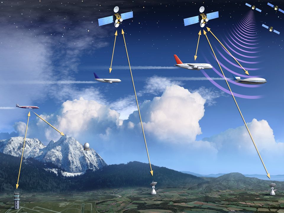
Satellite Communication Link

15
Basic terminologies: Earth Stations – antenna systems on or near earth Uplink – transmission from an earth station to a satellite Downlink – transmission from a satellite to an earth station Transponder – electronic circuitry in the satellite that converts uplink signals to downlink signals

16
Bands used for Communication are: Frequency BandDownlinkUplink C3.7 - 4.2 GHz5.925 - 6.425 GHz Ku11.7 - 12.2 GHz14.0 - 14.5 GHz Ka17.7 - 21.2 GHz27.5 - 31.0 GHz

18
Satellite Communication Large Coverage area Power Efficient System The satellite to satellite channel are less dependent on time than others radio channels. Very high bandwidths are possible Long delay (0.25 s for a GEO satellite).
..")
19
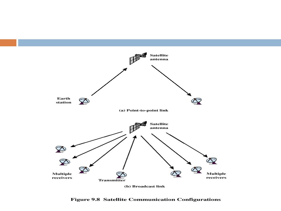
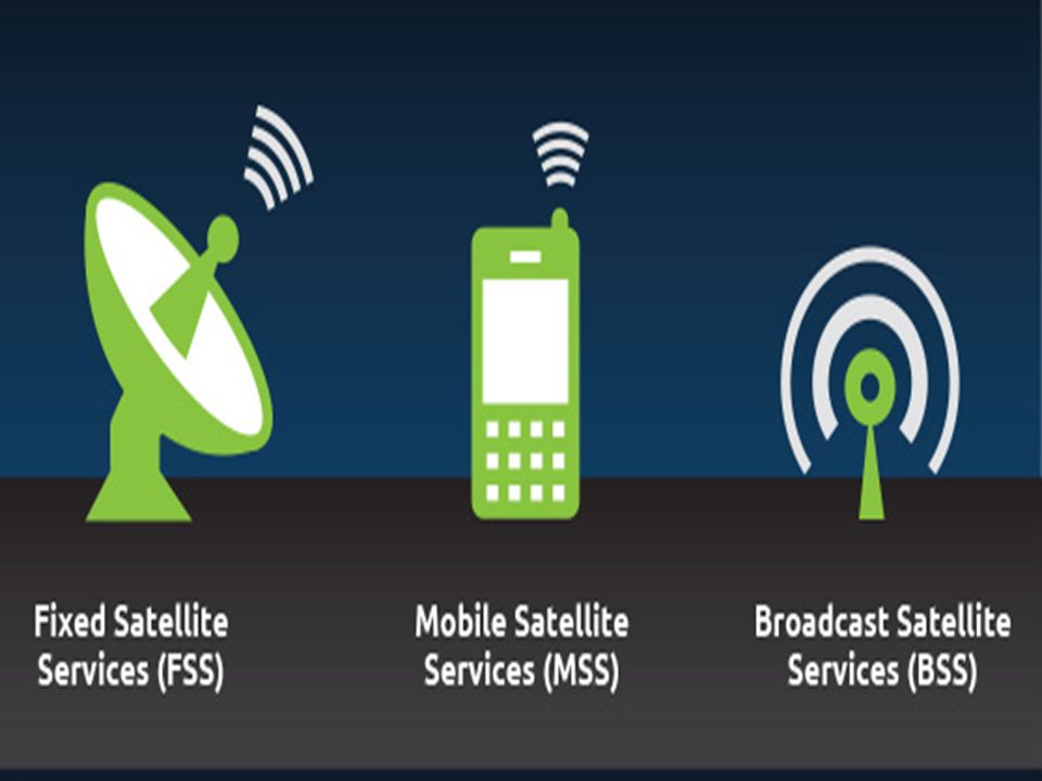
Ways to Categorize Communications Satellites Coverage area Global, regional, national Service type Fixed service satellite (FSS) Broadcast service satellite (BSS) Mobile service satellite (MSS) General usage Commercial, military, amateur, experimental
 Broadcast service satellite (BSS) Mobile service satellite (MSS) General usage Commercial, military, amateur, experimental")
21
Ways to Categorize Communications Satellites Coverage area Global, regional, national Service type Fixed service satellite (FSS) Broadcast service satellite (BSS) Mobile service satellite (MSS) General usage Commercial, military, amateur, experimental
 Broadcast service satellite (BSS) Mobile service satellite (MSS) General usage Commercial, military, amateur, experimental")
22
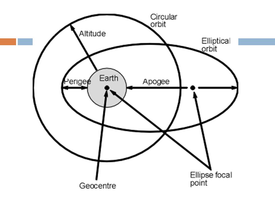
Classification of Satellite Orbits Circular or elliptical orbit Circular with center at earth’s center Elliptical with one foci at earth’s center

24
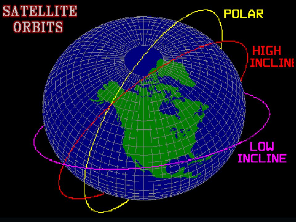
Classification of Satellite Orbits Circular or elliptical orbit Circular with center at earth’s center Elliptical with one foci at earth’s center Orbit around earth in different planes Equatorial orbit above earth’s equator Polar orbit passes over both poles Other orbits referred to as inclined orbits

26
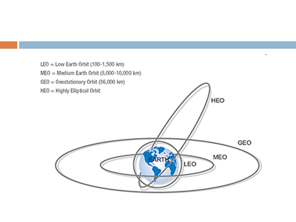
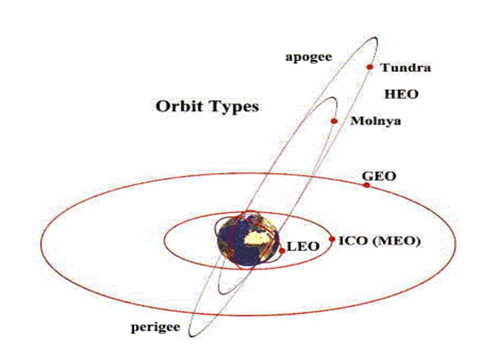
Classification of Satellite Orbits Circular or elliptical orbit Circular with center at earth’s center Elliptical with one foci at earth’s center Orbit around earth in different planes Equatorial orbit above earth’s equator Polar orbit passes over both poles Other orbits referred to as inclined orbits Altitude of satellites Geostationary orbit (GEO) Medium earth orbit (MEO) Low earth orbit (LEO) Highly Elliptical Orbit (HEO)
 Medium earth orbit (MEO) Low earth orbit (LEO) Highly Elliptical Orbit (HEO)")
28
Types of Satellites: Weather Satellites Broadcast Satellites Communications Satellite Scientific Satellites Navigational Satellites Rescue Satellites Earth observation Satellite Military Satellite Photography Satellites

29
Common things: 1. Metal or Composite frame body 2. Source of Power Solar cells Fuel cells Nuclear Power 3. On-board Computer 4. Has Radio system & antenna 5. Altitude control system

30
LEO Low Earth Orbit (range: 500-1500 km) Use: Communication Services Surveillance Activities Advantage over other: Ability to communicate with earth stations using much less power Smaller in Size less launching cost Uses 20dB(100 times) less power than GEO Propagation delay is much less than MEO
 Use: Communication Services Surveillance Activities Advantage over other: Ability to communicate with earth stations using much less power Smaller in Size less launching cost Uses 20dB(100 times) less power than GEO Propagation delay is much less than MEO")
31
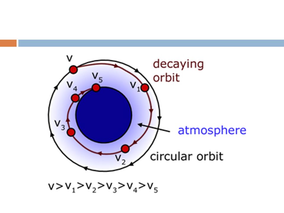
Disadvantages: Its speed makes it difficult to locate, trace and communicate with If altitude=1000km time required to encircle earth=100min Moving target is difficult to track as compared to stationary GEO More satellites are needed to achieve desired coverage on Earths surface 40 to 60 satellites(depending on exact orbital height) for complete Earth coverage Orbit decay Drag effect Rocket motors to counter the orbital decay Delays the crash until fuel runs out
 for complete Earth coverage Orbit decay Drag effect Rocket motors to counter the orbital decay Delays the crash until fuel runs out")
34
MEO Medium Earth Orbit (range: 5,000-15,000 km) Requires fewer satellites than LEO for total global coverage Time required to complete a round trip is less than that required by GEO These satellites are in view of any point of the earth for a longer time than LEO Hence effective in communication(provided they are reachable) Solving reachability problem: Footprint coverage overlap 10-17 satellites distributed over 2-3 orbital planes
 Requires fewer satellites than LEO for total global coverage Time required to complete a round trip is less than that required by GEO These satellites are in view of any point of the earth for a longer time than LEO Hence effective in communication(provided they are reachable) Solving reachability problem: Footprint coverage overlap satellites distributed over 2-3 orbital planes")
35
MEO Medium Earth Orbit (range: 5,000-15,000 km) Requires fewer satellites than LEO for total global coverage Takes 50ms to 150ms to complete a round trip(less than required by GEO) These satellites are in view of any point of the earth for a longer time than LEO Hence effective in communication(provided they are reachable) Solving reachability problem: Footprint coverage overlap 10-17 satellites distributed over 2-3 orbital planes
 Requires fewer satellites than LEO for total global coverage Takes 50ms to 150ms to complete a round trip(less than required by GEO) These satellites are in view of any point of the earth for a longer time than LEO Hence effective in communication(provided they are reachable) Solving reachability problem: Footprint coverage overlap satellites distributed over 2-3 orbital planes")
36
GEO Geosynchronous Earth Orbit (range: 35786 km) Orbital period of GEO satellite = Orbital period of Earth i.e. 24 hours Rotation is in same direction of the earth(i.e. same angular velocity) Overlies the same point on the earth Service area covered by a Geosynchronous satellite is 1/3 rd of Earths surface Hence min of 3-4 satellites are required for near global coverage Field view of such satellites is fixed Permanent satellite communication Repeated observations of fixed geographical area
 Overlies the same point on the earth Service area covered by a Geosynchronous satellite is 1/3 rd of Earths surface Hence min of 3-4 satellites are required for near global coverage Field view of such satellites is fixed Permanent satellite communication Repeated observations of fixed geographical area.")
37
GEO Geosynchronous Earth Orbit (range: 35786 km) Orbital period of GEO satellite = Orbital period of Earth i.e. 24 hours Rotation is in same direction of the earth(i.e. same angular velocity) Overlies the same point on the earth Service area covered by a Geosynchronous satellite is 1/3 rd of Earths surface Hence min of 3-4 satellites are required for near global coverage Takes 1-2 sec to complete a round trip(less than that required by GEO) Field view of such satellites is fixed Permanent satellite communication Repeated observations of fixed geographical area
 Overlies the same point on the earth Service area covered by a Geosynchronous satellite is 1/3 rd of Earths surface Hence min of 3-4 satellites are required for near global coverage Takes 1-2 sec to complete a round trip(less than that required by GEO) Field view of such satellites is fixed Permanent satellite communication Repeated observations of fixed geographical area.")
38
HEO Highly Elliptical Orbits Do not orbit the earth at a relative constant distance like most others instead they Dip and Dive Top of the orbit is called as “apogee” and the lower end is called as “perigee” Range from about 50,000 km to 500 km above Earths surface resp Handoff: After the apogee period of orbit, a handoff must occur between the satellite about to descend and the rising satellite after it

39
eg of HEO: Russian Molnya system 3satellites in three 12 hour orbits Separation between satellites is of 120 degrees Apogee-39354 km Perigee- 1000km Russian Tundra system employs 2 satellites Separation is of 180 degrees 24 hour orbits Apogee- 53622km Perigee- 17951km

41
Global Positioning System (GPS)
")
42
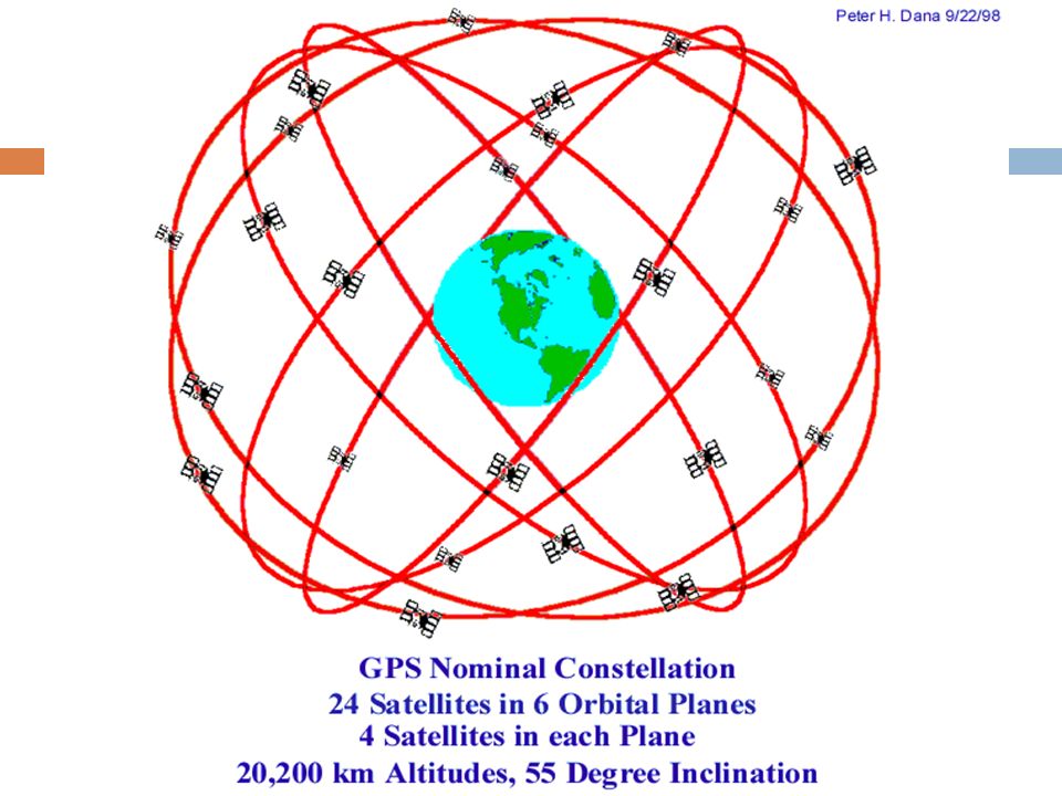
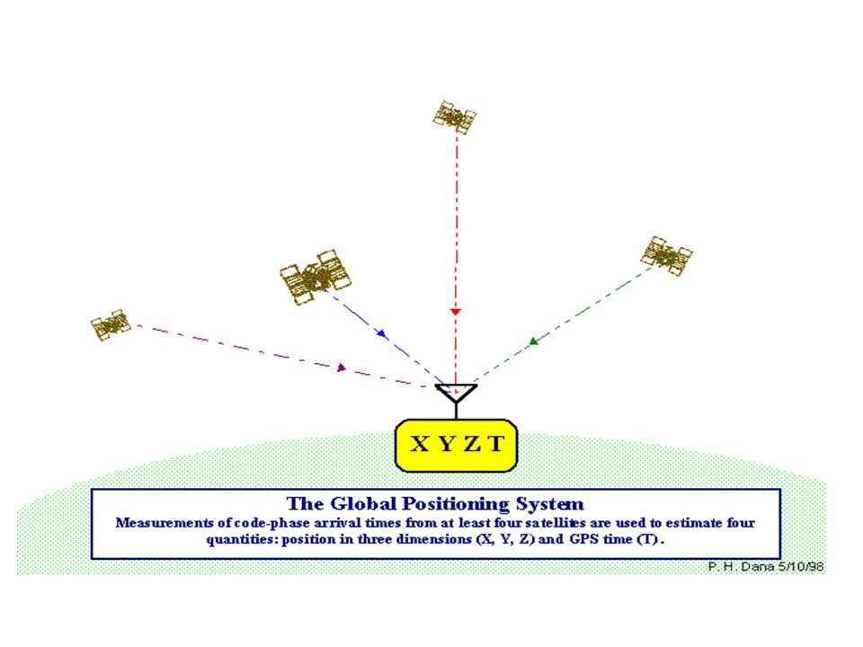
Design and principle of operation of Global Positioning System (GPS) Worldwide positioning system formed from, Constellation of 24 satellites and their ground stations Has 6 orbital planes (4 satellites in each plane) Uses man-made stars as reference to calculate exact position Its like giving every square meter on the earth a unique address GPS provides with specially coded satellite signals that can be processed in a GPS receiver enabling it to compute position, velocity and time. It provides us with the position in three dimensions

43
Satellite

50
Important Units of GPS: Satellite Segment Control Segment User Segment

51
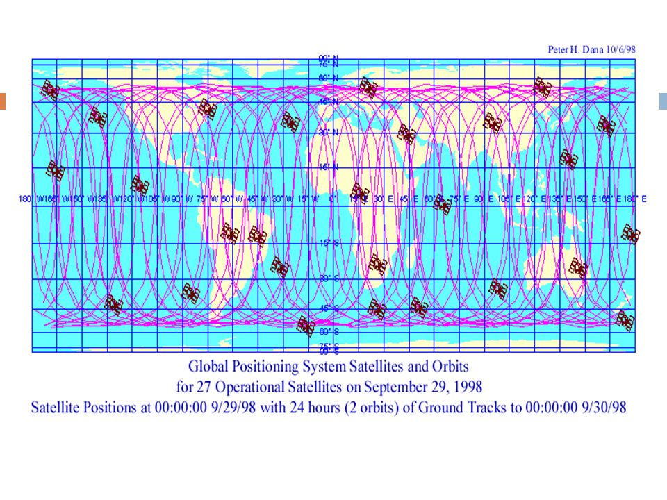
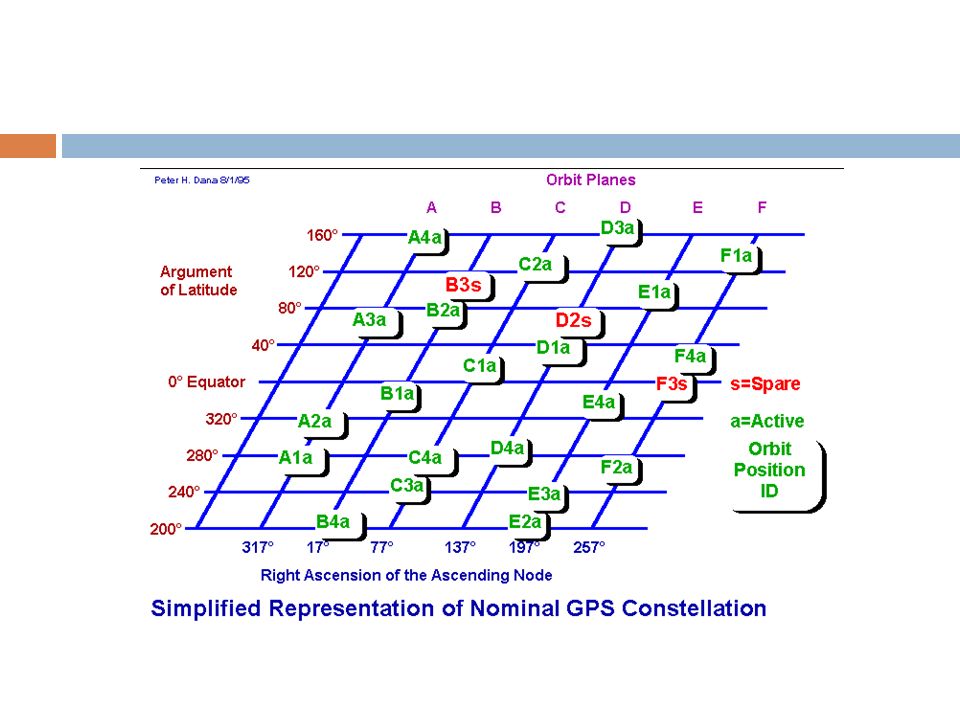
Satellite(Space) segment The space segment (SS) is composed of the orbiting GPS satellites, or Space Vehicles (SV) Six orbital planes with four satellites each The six orbit planes have approximately 55° inclination (tilt relative to the earth's equator) and are separated by 60° The orbital period is one-half a sidereal day, i.e., 11 hours and 58 minutes so that the satellites pass over the same locations The orbits are arranged so that at least six satellites are always within line of sight from almost everywhere on the earth's surface. The result of this objective is that the four satellites are not evenly spaced (90 degrees) apart within each orbit. In general terms, the angular difference between satellites in each orbit is 30, 105, 120, and 105 degrees apart, which sum to 360 degrees.
 apart within each orbit. In general terms, the angular difference between satellites in each orbit is 30, 105, 120, and 105 degrees apart, which sum to 360 degrees..")
53
The additional satellites, improve the precision of GPS receiver calculations by providing redundant measurements. the constellation was changed to a non-uniform arrangement. improve reliability availability of the system, relative to a uniform system, when multiple satellites fail.

54
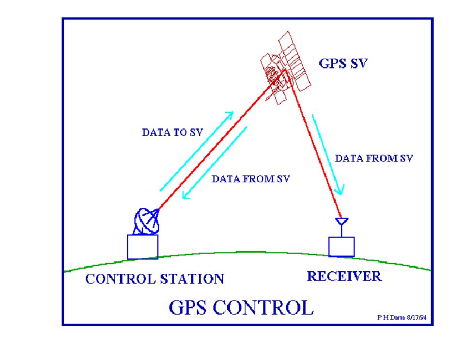
Control segment The control segment consists of: worldwide monitor & control stations These maintain the satellites in their proper orbit through, Occasional command Adjusting the satellite clocks Tasks performed: tracks the GPS satellites upload updated navigational data & maintains health and status of the satellite.

56
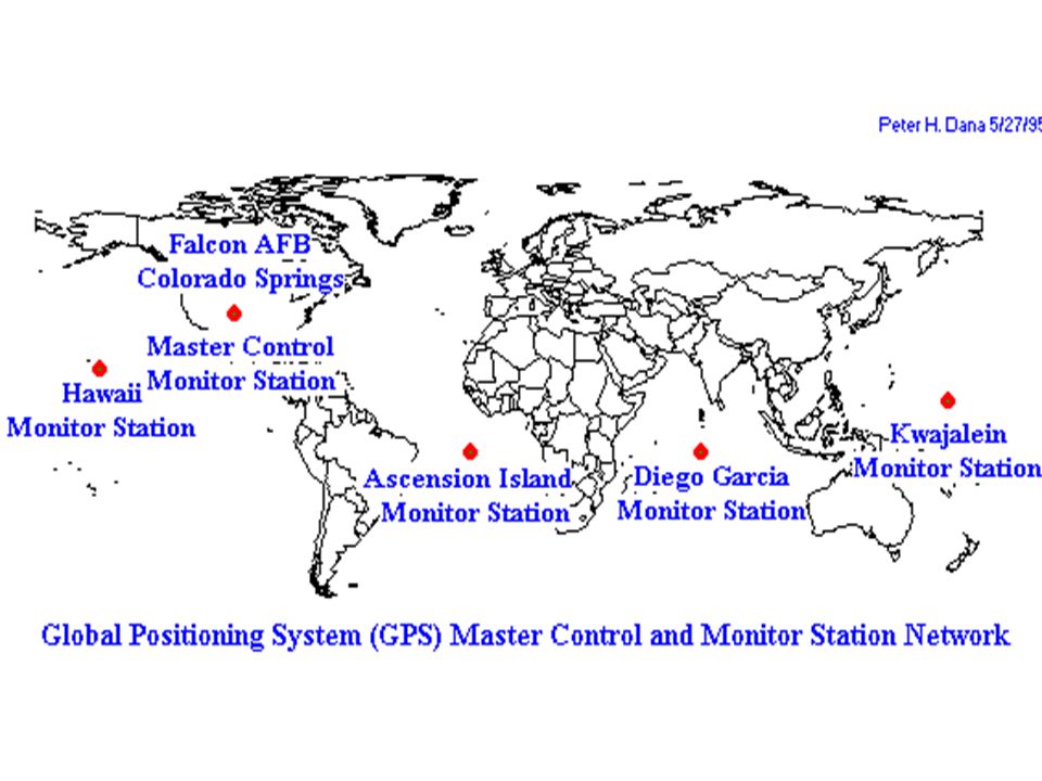
The control segment is composed of: a master control station (MCS), an alternate master control station, four dedicated ground antennas, and Six dedicated monitor stations.
, an alternate master control station, four dedicated ground antennas, and Six dedicated monitor stations.")
58
The Control Segment consists of a system of tracking stations located around the world. The Master Control facility is located at Schriever Air Force Base (formerly Falcon AFB) in Colorado. These monitor stations measure signals from the SVs which are incorporated into orbital models for each satellites. The models compute precise orbital data and SV clock corrections for each satellite. The Master Control station uploads orbital data and clock data to the SVs.
 in Colorado. These monitor stations measure signals from the SVs which are incorporated into orbital models for each satellites. The models compute precise orbital data and SV clock corrections for each satellite. The Master Control station uploads orbital data and clock data to the SVs..")
59
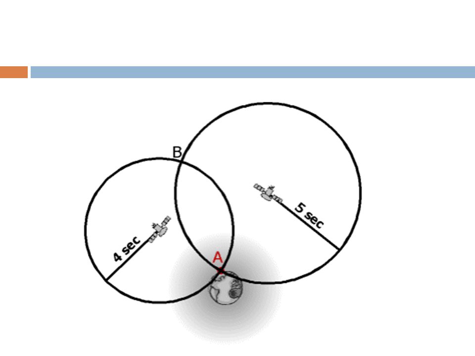
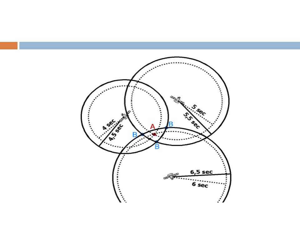
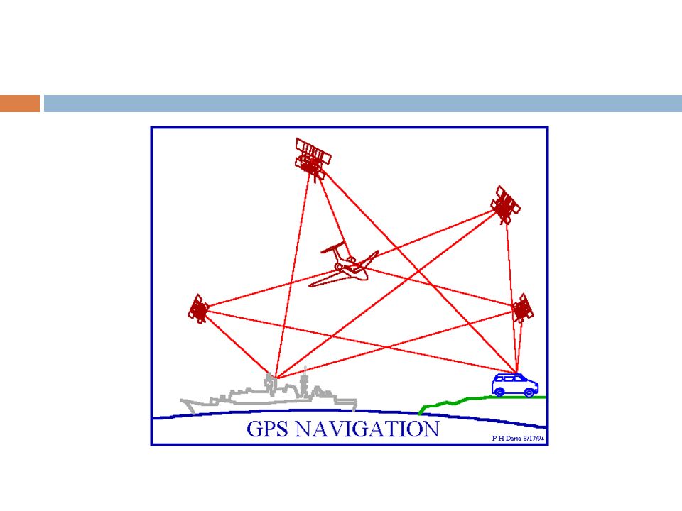
User segment The user segment consists of the GPS receivers and the user community. GPS receivers convert Satellite signals into position, velocity, and time estimates. A GPS receiver’s job is to, 1. locate four or more of these satellites 2. figure out the distance to each 3. and use this information to deduce its own location. 4. This operation is based on a simple mathematical principle called trilateration.

60
In order to make this simple calculation, the GPS receiver has to know two things: The location of at least three satellites above you The distance between you and each of those satellites The GPS receiver figures both of these things out by analyzing high- frequency, low-power radio signals from the GPS satellites. Better units have multiple receivers, so they can pick up signals from several satellites simultaneously.

62
Errors GPS errors are a combination of noise, bias, blunders. Noise : Noise errors are the combined effect of PRN code noise (around 1 meter) and noise surrounding the receiver(around 1 meter). Bias errors result from Selective Availability and other factors Selective Availability (SA) SA is the intentional degradation of the (Standard Positioning Service)SPS signals by a time varying bias. SA is controlled by the DOD to limit accuracy for non-U. S. military users. The potential accuracy of around 30 meters is reduced to 100 meters.
 and noise surrounding the receiver(around 1 meter). Bias errors result from Selective Availability and other factors Selective Availability (SA) SA is the intentional degradation of the (Standard Positioning Service)SPS signals by a time varying bias. SA is controlled by the DOD to limit accuracy for non-U. S. military users. The potential accuracy of around 30 meters is reduced to 100 meters..")
63
Other Bias Error sources; SV clock errors uncorrected by Control Segment can result in one meter errors. Ephemeris (orbital) data errors: 1 meter Tropospheric delays: 1 meter. The troposphere is the lower part (ground level to from 8 to 13 km) of the atmosphere that experiences the changes in temperature, pressure, and humidity associated with weather changes. Ionosphere delays: 10 meters. The ionosphere is the layer of the atmosphere from 50 to 500 km that consists of ionized air. Multipath: 0.5 meters. Multipath is caused by reflected signals from surfaces near the receiver that can either interfere with or be mistaken for the signal that follows the straight line path from the satellite. Multipath is difficult to detect and sometime hard to avoid.
 data errors: 1 meter Tropospheric delays: 1 meter. The troposphere is the lower part (ground level to from 8 to 13 km) of the atmosphere that experiences the changes in temperature, pressure, and humidity associated with weather changes. Ionosphere delays: 10 meters. The ionosphere is the layer of the atmosphere from 50 to 500 km that consists of ionized air. Multipath: 0.5 meters. Multipath is caused by reflected signals from surfaces near the receiver that can either interfere with or be mistaken for the signal that follows the straight line path from the satellite. Multipath is difficult to detect and sometime hard to avoid..")
64
Blunders can result in errors of hundred of kilometers. Control segment mistakes due to computer or human error can cause errors from one meter to hundreds of kilometers. User mistakes, including incorrect geodetic datum selection, can cause errors from 1 to hundreds of meters. Receiver errors from software or hardware failures can cause blunder errors of any size. Noise and bias errors combine, resulting in typical ranging errors of around fifteen meters for each satellite used in the position solution.

65
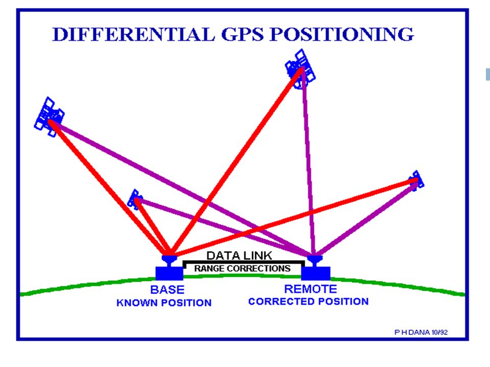
Differential GPS Differential Global Positioning System (DGPS) an enhancement to Global Positioning System provides improved location accuracy from the 15-meter nominal GPS accuracy to about 10 cm in case of the best implementations. DGPS uses a network of fixed, ground-based reference stations to broadcast the difference between the positions indicated by the GPS (satellite) systems and the known fixed positions.
 systems and the known fixed positions..")
67
Differential GPS These stations broadcast the difference between the measured satellite pseudoranges and actual (internally computed) pseudoranges, and receiver stations may correct their pseudoranges by the same amount. The digital correction signal is typically broadcast locally over ground-based transmitters of shorter range.

69
A reference station calculates differential corrections for its own location and time. Users may be up to 370 km from the station and some of the compensated errors vary with space: specifically, satellite ephemeris errors and those introduced by ionospheric and tropospheric distortions. For this reason, the accuracy of DGPS decreases with distance from the reference station. The problem can be aggravated if the user and the station lack "inter visibility"—when they are unable to see the same satellites. Ephemers- gives the positions of naturally occurring astronomical objects as well as artificial satellites in the sky at a given time or times

70
Errors reduced by DGPS

71
Future of GPS

72
Contents.. Communicating with a satellite LEOs, MEOs, GEOs and HEOs systems Design and principle of operation of Global Positioning System (GPS) Satellite, control and user segments Differential GPS Future of GPS
 Satellite, control and user segments Differential GPS Future of GPS.")
73
UNIT:- 6 Q. 1 ) Explain the operation and principle of GPS. Q. 2 ) Explain satellite communication with its advantage and disadvantage. Q. 3 ) Explain LEO, MEO system in detail. Q. 4 ) Explain control and user segments of GPS. Q. 5 ) Explain the following :- Satellite Footprint Path Diversity. Q. 6 ) What is differential GPS ? Explain. Q. 7 ) Write a note on TELEDESIC satellite. Q. 8 ) What are satellite control and user segments?
 Explain satellite communication with its advantage and disadvantage. Q. 3 ) Explain LEO, MEO system in detail. Q. 4 ) Explain control and user segments of GPS. Q. 5 ) Explain the following :- Satellite Footprint Path Diversity. Q. 6 ) What is differential GPS . Explain. Q. 7 ) Write a note on TELEDESIC satellite. Q. 8 ) What are satellite control and user segments .")
Similar presentations


. NAVSTAR Global Positioning System (GPS) Globally.>")


>")

 work>")


 uses.>")