Download presentation
Presentation is loading. Please wait.

1
Ocean Monitoring and Forecasting A Commercial Perspective Dr Ralph Rayner Ocean Numerics/Fugro GEOS

4
Understanding the oceans for practical commercial purposes has been a goal since the early days of ocean trade

6
Safe and effective offshore operations

9
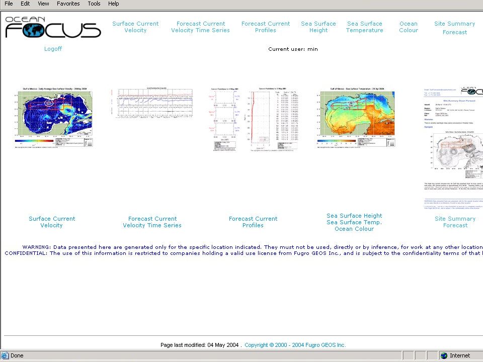
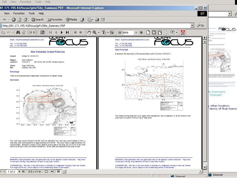
Understanding and quantifying ocean behaviour to support practical decision- making Strong Science for Wise Decisions ‘Effective policies should be based on unbiased, credible, and up- to-date scientific information…… High quality, accessible information is critical to making wise decisions about ocean and coastal resources and their uses to guarantee sustainable social, economic, and environmental benefits from the sea’. Preliminary Report of the U.S. Commission on Ocean Policy - Governors' Draft 20th April 2004

10
Integrating cutting edge science and advanced technology Satellite Remote Sensing of the oceans Satellite Remote Sensing of the oceans Numerical Modelling Numerical Modelling In situ observations In situ observations Information Management and Dissemination tools Information Management and Dissemination tools

11
Data Management System Data Assimilation Forecast Delivery Interpretation Operational Ocean Model Ocean Satellite Observations In Situ Ocean Measurements QC

12
Data Management System Data Assimilation Forecast Delivery Interpretation Operational Ocean Model Ocean Satellite Observations In Situ Ocean Measurements QC

13
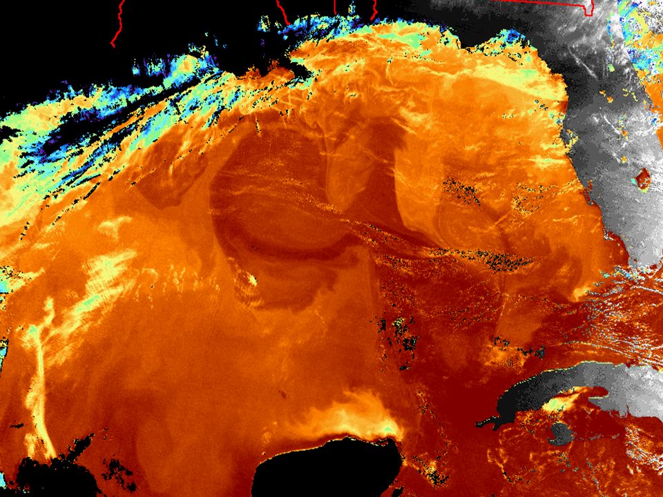
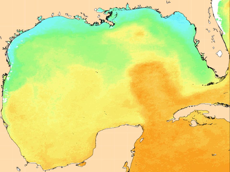
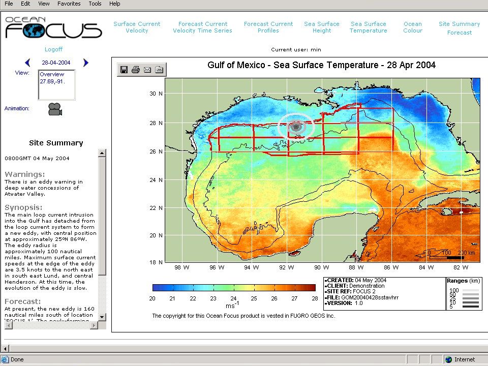
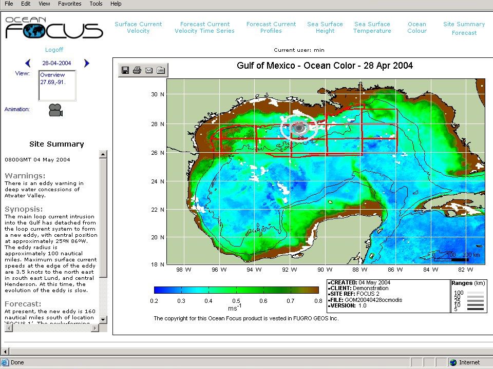
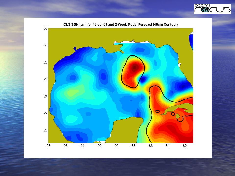
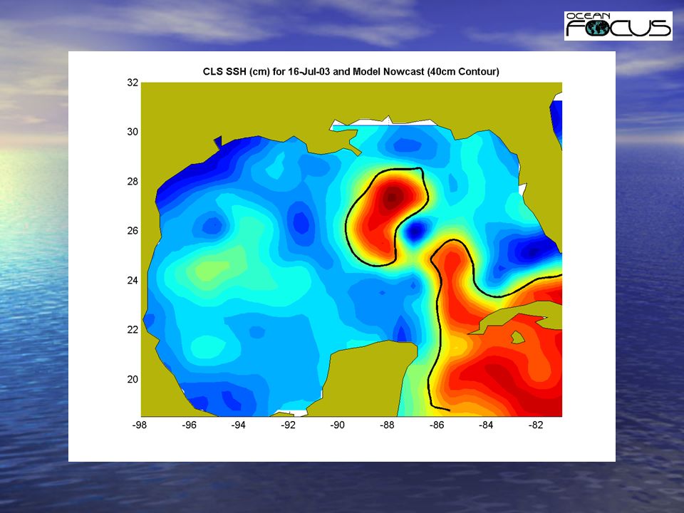
Earth Observation data Altimetric measurements of Sea Surface Height: optimally blended from TOPEX- Poseidon, JASON-1, ENVISAT and GFO. Altimetric measurements of Sea Surface Height: optimally blended from TOPEX- Poseidon, JASON-1, ENVISAT and GFO. Sea Surface Temperature: from NOAA- AVHRR infrared radiometer Sea Surface Temperature: from NOAA- AVHRR infrared radiometer Ocean Surface Color: MODIS/AQUA Ocean Surface Color: MODIS/AQUA

17
Data Management System Data Assimilation Forecast Delivery Interpretation Operational Ocean Model Ocean Satellite Observations In Situ Ocean Measurements QC

18
Modelling HYCOM - State of the art community model system developed by consortium including NERSC, University of Miami, US Navy, Los Alamos etc HYCOM - State of the art community model system developed by consortium including NERSC, University of Miami, US Navy, Los Alamos etc Implemented in forecast mode for the Atlantic Basin through a major EU Framework project – TOPAZ Implemented in forecast mode for the Atlantic Basin through a major EU Framework project – TOPAZ TOPAZ model system now forms basis for the operational modelling behind the Ocean Focus product TOPAZ model system now forms basis for the operational modelling behind the Ocean Focus product

19
HYCOM - The HYbrid Co-ordinate Ocean Model

20
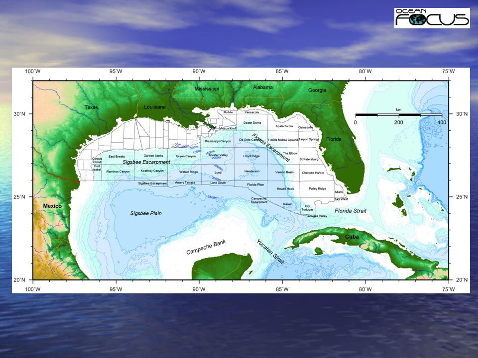
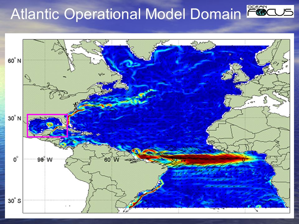
Atlantic Operational Model Domain

22
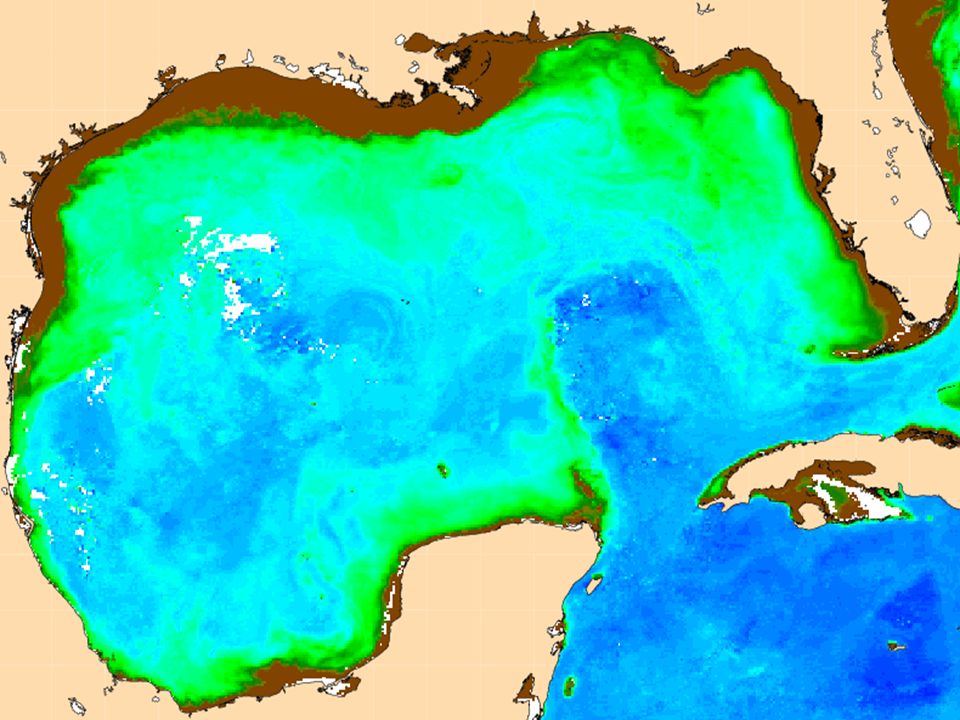
Gulf Operational Model Domain

23
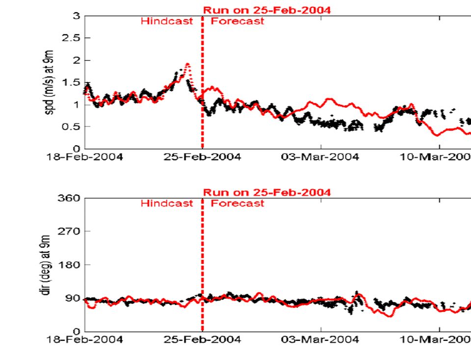
Model attributes Horizontal resolution: 5km (1/24 degree) Horizontal resolution: 5km (1/24 degree) Vertical resolution: 22 hybrid layers Vertical resolution: 22 hybrid layers Assimilation technique: Ensemble OI Assimilation technique: Ensemble OI Boundary conditions: nested in HYCOM Atlantic basin forecast model running with EnKF assimilation Boundary conditions: nested in HYCOM Atlantic basin forecast model running with EnKF assimilation Runs on weekly basis for 30 day-forecast Runs on weekly basis for 30 day-forecast
 Horizontal resolution: 5km (1/24 degree) Vertical resolution: 22 hybrid layers Vertical resolution: 22 hybrid layers Assimilation technique: Ensemble OI Assimilation technique: Ensemble OI Boundary conditions: nested in HYCOM Atlantic basin forecast model running with EnKF assimilation Boundary conditions: nested in HYCOM Atlantic basin forecast model running with EnKF assimilation Runs on weekly basis for 30 day-forecast Runs on weekly basis for 30 day-forecast")
24
Data Management System Data Assimilation Forecast Delivery Interpretation Operational Ocean Model Ocean Satellite Observations In Situ Ocean Measurements QC

26
ADAM ADAM - ADCP Data Acquisition Manager developed and operated by Fugro GEOS ADAM - ADCP Data Acquisition Manager developed and operated by Fugro GEOS allows real-time access over the Internet to data from ADCP’s operated throughout the Gulf of Mexico allows real-time access over the Internet to data from ADCP’s operated throughout the Gulf of Mexico

27
ADAM - Components Three components: database database data loader data loader web-based interface for viewing and system management web-based interface for viewing and system management

28
ADAM - Spatial Display

29
ADAM - Times Series Display

30
ADAM - Profile Display

31
Data Management System Data Assimilation Forecast Delivery Interpretation Operational Ocean Model Ocean Satellite Observations In Situ Ocean Measurements QC

32
Data management system EO service products ) ENVISAT RA2-MERIS-AATSR ) Feature detection and tracking; mapping, images ) DUACS update ) Data formatting In situ data processing Model service products Circulation modelling Eddy tracking by SAR Data Assimilation Forecasting Monitoring services (near real time) Production and supply of service products Metocean statistics Forecasting services Production and supply of service products FTP DISSEMINATION TO CUSTOMERS: E-MAIL WWW HUMAN CONTACT Data Ware- house Input Data
 ENVISAT RA2-MERIS-AATSR ) Feature detection and tracking; mapping, images ) DUACS update ) Data formatting In situ data processing Model service products Circulation modelling Eddy tracking by SAR Data Assimilation Forecasting Monitoring services (near real time) Production and supply of service products Metocean statistics Forecasting services Production and supply of service products FTP DISSEMINATION TO CUSTOMERS: WWW HUMAN CONTACT Data Ware- house Input Data")
33
Data management system Fully databased structure Fully databased structure System monitored and supported 24 x 7 System monitored and supported 24 x 7 Secure access Secure access Web/e-mail/fax distribution Web/e-mail/fax distribution

34
Data management system Have developed the capacity to acquire and process all data in near real- time, integrate it, and assimilate it into an advanced modelling system Have developed the capacity to acquire and process all data in near real- time, integrate it, and assimilate it into an advanced modelling system Linked to capacity to distribute reliable forecasts set in a context of remote sensed and in situ observations Linked to capacity to distribute reliable forecasts set in a context of remote sensed and in situ observations

35
Data Management System Data Assimilation Forecast Delivery Interpretation Operational Ocean Model Ocean Satellite Observations In Situ Ocean Measurements QC

47
Ocean FOCUS’ – Next Steps Development of improved verification techniques Development of improved verification techniques Further technical development Further technical development Application to other key goegraphical areas Application to other key goegraphical areas

53
Ocean FOCUS - Further Development ESA ‘EMOFOR’ Project ESA ‘EMOFOR’ Project NOPP HYCOM Consortium NOPP HYCOM Consortium FP6 ‘MERSEA’ Integrated Project FP6 ‘MERSEA’ Integrated Project

54
Other geographical regions West Africa West Africa Barents Sea Barents Sea Indian Ocean Indian Ocean South China Sea South China Sea Brazil Brazil

Similar presentations


 A demonstration space mission dedicated to land surface environment (Vegetation and Environment New.>")
/NOAA Member, National Tsunami.>")


