Download presentation
Presentation is loading. Please wait.

1
Northfield’s Green Infrastructure Northfield’s Landscape Northfield’s Landscape Trends Trends What is Green Infrastructure? What is Green Infrastructure? Visioning Visioning

2
HRWC is Michigan’s first and oldest watershed council ~ a coalition of local communities and residents established under state law in 1965 to protect the Huron River and its tributary streams, lakes, wetlands and groundwater. Stockbridge

3
The Huron River Watershed Green Infrastructure Services Funding provided from the Americana Foundation

4
Northfield’s Natural Assets

5
Landscape Mostly undeveloped Mostly undeveloped 31% intact natural areas (“bioreserve sites”) 31% intact natural areas (“bioreserve sites”) Only 5 % of natural areas publicly owned) Only 5 % of natural areas publicly owned) Low impervious surface (5%) Low impervious surface (5%)
 31% intact natural areas ( bioreserve sites ) Only 5 % of natural areas publicly owned) Only 5 % of natural areas publicly owned) Low impervious surface (5%) Low impervious surface (5%)")
6
Conifers Central Hardwoods Lowland Conifer Lowland Hardwoods Marsh/Meadow/Prairie Shrub Wetland Oak Openings Upland Grassland/Herb. Shrubland Water Landscape of the Huron River Watershed, 1800’s Ann Arbor Detroit Milford Chelsea Brighton Northfield

7
Conifers Central Hardwoods Lowland Conifer Lowland Hardwoods Marsh/Meadow/Prairie Shrub Wetland Oak Openings Upland Grassland/ Herb. Shrubland Water Landscape of the Huron River Watershed, 1800’s

8
Oak/hickory forest Photos: Ann Arbor NAP

9
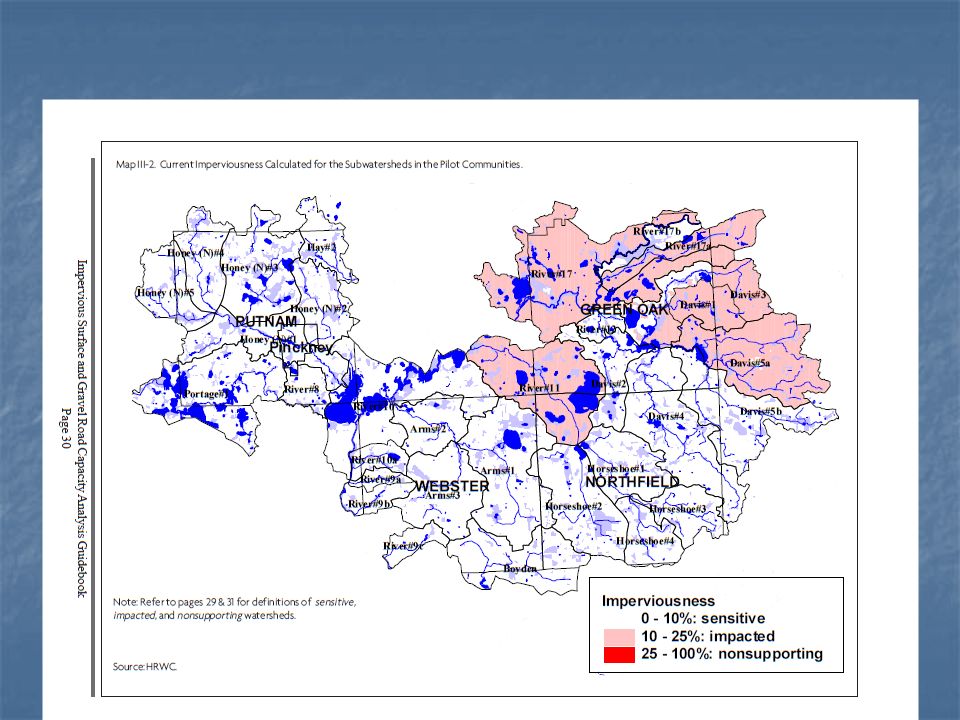
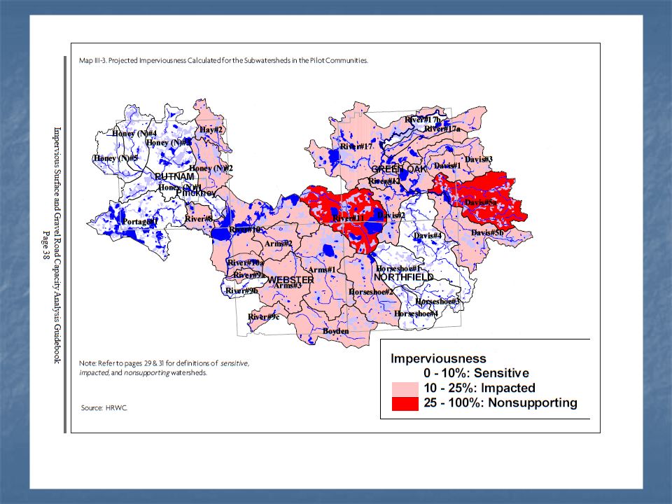
Oak savannah/barren/tallgrass praire Photos: Ann Arbor NAP

10
Beech/maple forest Photo: Ann Arbor NAP

11
Lowland hardwood forest Tamarack swamp Ann Arbor NAP Joshua G. Cohen

12
Inland wet prairie Photo: Ann Arbor NAP

13
Marsh/wetland

14
Massasauga White lady slipper Threatened, Endangered, Special Concern: 9 animals 16 plants 1 ecosystem: Oak barrens Heron rookery

15
Benefits of Natural Areas Store and cycle nutrients Conserve and generate soils Pollinate crops and other plants Pest control Forest and food products Wildlife Habitat Recreation Scenery Biodiversity/ Genetic library Clean Air Regulate climate Photos: Ann Arbor NAP Filter & Cool Runoff Water supply Groundwater Recharge Storm and flood damage protection Erosion control

16
$1.8 billion/year in West Michigan

17
Little runoff prior to development Water infiltrates into humus and into humus and porous soil Plants take up much water

19
Most rain flows THROUGH the ground. Few plants, Hard surfaces Plants intercept the rain Pre-DevelopmentPost-Development Most rain flows OVER the ground.

20
Under 10% Impervious Surface Low banks Low banks Natural buffer Natural buffer Good habitat Good habitat Cool water Cool water Clear water Clear water

21
Between 10 and 25% Impervious Surface Higher, undercut banks Higher, undercut banks sediment sediment Less diverse habitat Less diverse habitat Warmer water Warmer water

22
Over 25% Impervious Surface Steep, eroded banks Steep, eroded banks Little buffer Little buffer Very little habitat Very little habitat Warm water Warm water flashy flashy

23
Trends

24
Conifers Central Hardwoods Lowland Conifer Lowland Hardwoods Marsh/Meadow/Prairie Shrub Wetland Oak Openings Upland Grassland/ Herb. Shrubland Water Landscape of the Huron River Watershed, 1800’s

25
Landscape of the Huron River Watershed, 2000

26
Natural area trends in the Huron Fragmentation Fragmentation Loss of wetlands (about 50%) Loss of wetlands (about 50%) Loss of oak barrens, prairies, wooded wetlands, tamarack swamp Loss of oak barrens, prairies, wooded wetlands, tamarack swamp
 Loss of wetlands (about 50%) Loss of oak barrens, prairies, wooded wetlands, tamarack swamp Loss of oak barrens, prairies, wooded wetlands, tamarack swamp")
27
Future Trends 40% of the remaining open space is projected to be developed in the next 20 years40% of the remaining open space is projected to be developed in the next 20 years Master Plans and Zoning Ordinance build outs show little designated natural areaMaster Plans and Zoning Ordinance build outs show little designated natural area Almost all natural areas in private ownership and designated for some kind of useAlmost all natural areas in private ownership and designated for some kind of use Current development patterns are low density = more natural area converted per new personCurrent development patterns are low density = more natural area converted per new person

30
FutureLandUse Downtown vision plan Parks and Rec plan “continued commitment to community planning goals and policies geared to preserving important natural features, while planning for growth in those areas most suitable for development”

31
Keeping Northfield Healthy

32
HRWC Key Message To maintain the Huron River watershed’s health: I. Encourage higher density where infrastructure already exists. I. Encourage higher density where infrastructure already exists. II.Preserve natural areas so they can continue to provide the ecological services necessary to maintain quality of water, air, land, and life.

33
The Huron River Watershed Bioreserve Project To assess & protect the watershed’s last remaining natural areas Funding provided by the Americana and Carls foundations

34
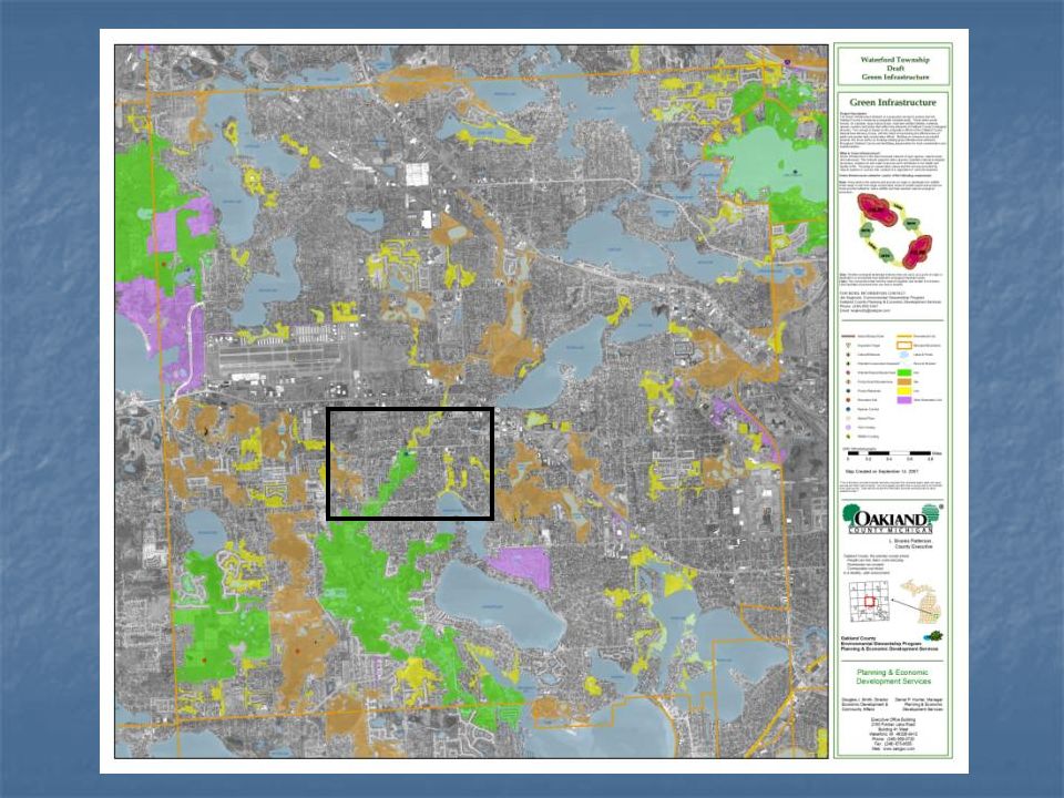
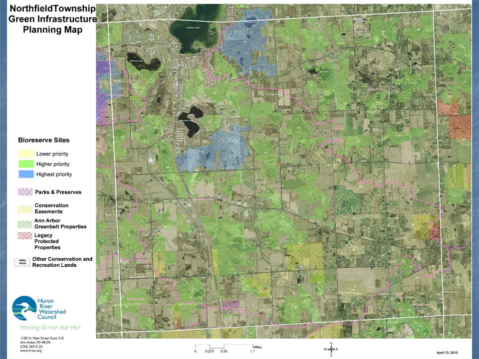
Bioreserve Map: based on aerials

35
Ranked Bioreserve Sites 15 criteria Total size Total size Size of core Size of core Topographic diversity Topographic diversity Geological diversity Geological diversity Waterway Waterway Upland/wetland Upland/wetland Remnant plant community Remnant plant community Groundwater recharge Groundwater recharge Connectivity Connectivity Corridors Corridors Restorability Restorability Amount of change since 1800 Amount of change since 1800 Fragmentation Fragmentation MNFI “bio-rarity” index MNFI “bio-rarity” index MNFI “special” communities MNFI “special” communities

36
Field Assessment Assessing ecological integrity Ground Truth GIS map Ground Truth GIS map Get more information about the natural area Get more information about the natural area Help Conservancies protect most important lands Help Conservancies protect most important lands Help with stewardship of natural lands Help with stewardship of natural lands

37
Northfield’s remaining natural areas Field Assessments in Northfield Doing assessments this summer

38
What you can do Design higher density, livable neighborhoods Design higher density, livable neighborhoods Live in a walkable community Live in a walkable community Plant trees, native plants in your lawn Plant trees, native plants in your lawn Keep water on your land Keep water on your land Control stormwater runoff Control stormwater runoff Leave natural buffers around creeks, wetlands, and ponds Leave natural buffers around creeks, wetlands, and ponds Keep natural lands natural Keep natural lands natural Permanently preserve larger, intact, natural lands Permanently preserve larger, intact, natural lands Join us in assessing the creek and its landscapes Join us in assessing the creek and its landscapes

39
Green infrastructure is the interconnected network of open spaces, natural areas and waterways Green infrastructure is the interconnected network of open spaces, natural areas and waterways Focusing on conservation values and the services provided by natural systems in concert with, instead of in opposition to, land development Focusing on conservation values and the services provided by natural systems in concert with, instead of in opposition to, land development Gives us an opportunity to Identify, Protect & Enhance our Natural Assets Gives us an opportunity to Identify, Protect & Enhance our Natural Assets What is Green Infrastructure? NaturalBuilt

40
Green infrastructure networks consist of the following components: Hubs: Hubs anchor the network and provide an origin or destination for wildlife. Sites: Smaller ecological landscape features that can serve as a point of origin or destination Links: The connections that hold the network together and enable it to function. Links facilitate movement from one hub to another. Hub Hub LinkSites GI Background

41
Network Anchor (Hub) Large Natural Area/Park Network Anchor (Hub) Large Natural Area/park Network Anchor (Hub) Large Natural Area/park Small Forested Area (site) Small Wetland Area (site) Small Natural Area (site) Tree Rows (Link) Fence & Hedge Rows (Link) River or Stream (Link)
 Large Natural Area/Park Network Anchor (Hub) Large Natural Area/park Network Anchor (Hub) Large Natural Area/park Small Forested Area (site) Small Wetland Area (site) Small Natural Area (site) Tree Rows (Link) Fence & Hedge Rows (Link) River or Stream (Link)")
42
HRWC

46
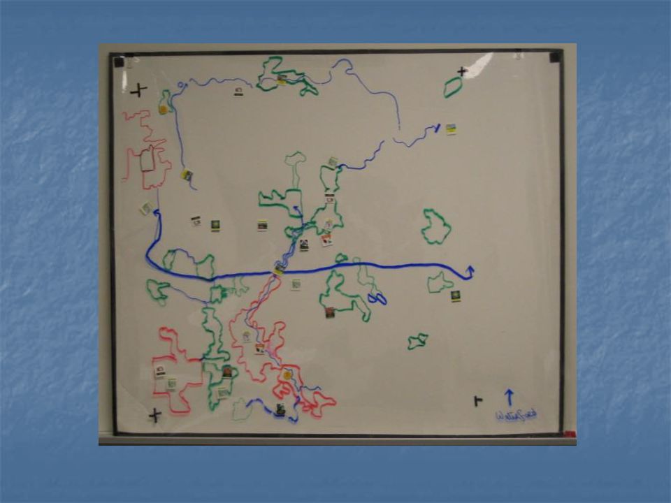
Example

47
Land Trust ConservationEasements Natural Beauty Road Designation Interpretive/E ducational Signage Open Space Clustering NativeLandscaping LandDonationParks Land Acquisition LakeBuffer LakeBuffer Trail Links Example

48
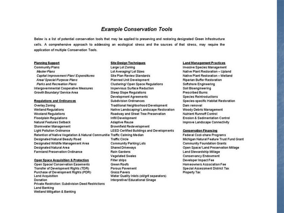
In urban environments, green infrastructure includes green roofs, trees, rain gardens, vegetated swales, pocket wetlands, parks, riparian buffers, no-mow zones, floodplains and strategically placed forested areas. Green Roof Riparian Buffers Rain Garden Vegetated Swales Pocket Wetlands Floodplains Riparian Buffers Parks Wild Corners Program

49
Open-Space Millage Park Acquisition Target Promote Native/Natural Landscaping Conservancy Coordination Grant Support Master Plan Wetland Mitigation Recreation Plan Master Plan Grant Support Partnership Building - Collaboration Promote no-mow zones Using the Green Infrastructure Vision

Similar presentations