Download presentation
Presentation is loading. Please wait.

1
ES. 10: Oceans: The student will investigate and understand that oceans are complex, interactive physical, chemical, and biological systems and are subject to long- and short-term variations. Key concepts include a) physical and chemical changes related to tides, waves, currents, sea level and ice cap variations, upwelling, and salinity variations; b) importance of environmental and geologic implications; c) systems interactions; d) features of the seafloor as reflections of tectonic processes; and e) economic and public policy issues concerning the oceans and the coastal zone including the Chesapeake Bay.
 physical and chemical changes related to tides, waves, currents, sea level and ice cap variations, upwelling, and salinity variations; b) importance of environmental and geologic implications; c) systems interactions; d) features of the seafloor as reflections of tectonic processes; and e) economic and public policy issues concerning the oceans and the coastal zone including the Chesapeake Bay..")
2
Essential Questions: What is the relationship between upwelling and an El Nino event? How do storms, surface currents, and density currents help distribute excess thermal energy throughout the ocean? Essential Understandings: The ocean is a dynamic system in which many chemical, biological, and physical changes are taking place. The oceans are an important source of food and mineral resources as well as a venue for recreation and transportation. Sea level falls when glacial ice caps grow and rises when the ice caps melt. Most waves on the ocean surface are generated by wind. There are large current systems in the oceans that carry warm water towards the poles and cold water towards the equator. Upwelling brings cold, nutrient-rich water from the deep ocean to the surface and produces areas of rich biological activity. The tides are the periodic rise and fall of water level caused by the gravitational pull of the sun and moon. Algae in the oceans are an important source of atmospheric oxygen. The ocean is the single largest reservoir of heat at Earth’s surface. The stored heat in the ocean drives much of Earth’s weather and causes climate near the ocean to be milder than climate in the interior of continents. Convection is the major mechanism of energy transfer in the oceans, atmosphere, and Earth’s interior.

3
71% of the earth is covered in water! Oceanography - the study of oceans Oceanographers - people who study the oceans Tools of oceanography - sonar, satellites, submersibles

4
The first oceans formed about 4 billion years ago Where did the water come from? ◦ impacting meteors ◦ water vapor vented from volcanoes

5
Most waves are generated by wind Water moves in a circular pattern not forward When waves hit shallow water, the friction slows the bottom of the wave

6
Tsunami A tsunami is a series of ocean waves generated by sudden displacements in the sea floor, landslides, or volcanic activity. In the deep ocean, the tsunami wave may only be a few inches high. The tsunami wave may come gently ashore or may increase in height to become a fast moving wall of turbulent water several meters high.

7
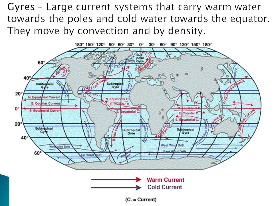
◦ Density currents water moved by changes in salinity and temperature ◦ Surface currents Wind driven, affect the top 100 m of the ocean ◦ Upwelling Occurs when the surface water is pushed aside and is replaced by cold water from deep in the ocean

9
Caused by gravity of the moon and the Sun - Lunar tides are twice as high as solar tides - High Tide: highest level to which water rises - Low Tide: lowest level to which water falls - The daily cycle of tides takes 24 hrs 50 min Tides vary based on location and topography - Gulf of Mexico has small tidal range (1 m) - Bay of Fundy has the greatest tidal range (15m)
 - Bay of Fundy has the greatest tidal range (15m)")
10
Contains 96.5% water and 3.5% dissolved salts ◦ 35ppt = 35 parts per thousand Constant salt content - salts are removed at the same rate they are added Density varies with change in salinity or temperature ◦ Due to high salinity, it is very easy to float in the Dead Sea ◦ Cold, salty water is the most dense

11
Water heats up and cools off more slowly than land. This difference in temperature can cause both global and local winds. Warm, less dense air rises Cold, denser air flows in to replace warm air Warm, less dense air rises

12
Temperatures range from -2°C at the poles, to 30°C at the equator Temperature decreases with depth 3 layers of the ocean ◦ Surface layer (warmest) ◦ thermocline ◦ bottom layer
 ◦ thermocline ◦ bottom layer")
14
Multi Beam SONAR Systems ◦ bounces sound off the seafloor to measure the ocean depth. A pulse of sound of energy is sent toward the seabed every 10 seconds. ◦ may have as many as 121 beams radiating from the ship’s hull. ◦ With that researchers can build a complete map of the area they are testing. How do we know what the bottom looks like?

15
Key Ideas: The ocean covers 70 % of the Earth. It contains dissolved salts with ions such as chloride, sodium, magnesium, and potassium. Salinity is a measure if the amount of salts dissolved in seawater. Almost all of the energy that heats up the oceans comes from the sun, but light and heat do not penetrate very deeply into the ocean. The stored heat in the ocean drives much of the Earth’s weather. The stored heat in the ocean causes climate near the ocean to be milder than the climate in the interior of continents

16
Key Ideas: Ocean water moves by currents and waves. Most waves on the ocean surface are generated by wind. The top of a wave is the crest; the bottom is the trough. The distance between two crests or troughs is the wavelength. The distance between the crest and the trough is the wave height. A tsunami is a very large wave produced by seismic activity on the ocean floor. There are large current systems called gyres in the oceans that carry warm water towards the poles and cold water towards the equator. They move by convection and by density. Upwelling brings cold, nutrient-rich water from the deep ocean to the surface and are areas of rich biological activity.

17
Key Ideas: The tides are the daily periodic rise and fall of water level caused by the gravitational pull of the sun and moon. Spring tides occur when the Sun, Earth and Moon are in a straight line making high tides higher and low tides lower. Neap tides occur when the Sun and the Moon are at right angles to the Earth making high tides lower and low tides higher. Oceanographers divide the ocean into three temperature layers. The surface zone is warm with sunlight. The surface zone is also called the mixed layer because wind and waves mix heat evenly through this zone. The layer of ocean directly beneath the mixed layer, in which the temperature changes rapidly, is called the thermocline. This middle zone is penetrated by little light. The middle zone has a cold temperature. The deep zone is very cold and has no sunlight.

18
Essential Questions: What common bathymetric features are found on a seafloor profile? What are the key differences between active and passive margins? Essential Understandings: The topography of the seafloor is at least as variable as that on the continents. Features of the seafloor that are related to plate tectonic processes include mid-ocean ridges and trenches (continental margins, trenches, and mid-ocean ridges). Other major topographic features of the oceans are continental shelves, continental slopes, abyssal plains, and seamounts.
. Other major topographic features of the oceans are continental shelves, continental slopes, abyssal plains, and seamounts..")
19
Three main divisions: ◦ continental shelf: shallow, nearly flat, close to shore ◦ continental slope: seaward, more steeply sloped ◦ continental rise: blends the continental margins into deep sea basins

20
Submarine Canyons A submarine canyon is a steep-sided valley cut into the sea floor of the continental slope. They are carved out by turbidity currents. Turbidity currents are underwater landslide.

21
Abyssal Plains- flat, featureless expanses of sediment covered ocean floor Most common in Atlantic & rare in Pacific Lie between oceanic ridges & continental margins Sediments mostly from shallow-water origins Abyssal Hills- small, sediment-covered extinct volcanoes or intrusions of once- molten rock (< 200 meters or < 650 feet) Associated with seafloor spreading almost all the area of the deep-ocean floor not part of oceanic ridge system
 Associated with seafloor spreading almost all the area of the deep-ocean floor not part of oceanic ridge system")
22
Seamounts ◦ volcanic projections that don’t rise above sea surface Guyots ◦ flat-top seamounts once tall enough to approach the sea surface

23
Chain of mountains made of young basaltic rock at the active spreading center of an ocean devoid of sediments rise about 2km above seafloor may form islands In the middle of the mid-ocean ridge is the rift valley. This is the location of the ‘crack’ in the plates.

24
(black smokers)- spring of hot, mineral & gas-rich seawater found on some oceanic ridges in zones of active seafloor spreading ◦ water descends through cracks in ridge floor ◦ comes in contact with very hot rocks (assoc. with active seafloor spreading) ◦ superheated & chemically active water dissolves minerals & gases ◦ heated water then escapes upwards through vents b/c of convection
 ◦ superheated & chemically active water dissolves minerals & gases ◦ heated water then escapes upwards through vents b/c of convection.")
25
Trenches- arc-shape depression in deep-ocean floor Occur where converging oceanic plate is subducted Among most active geological feature on earth Earthquakes & tsunamis often originate in trenches Deepest places in earth’s crust Mariana Trench- Pacific ocean Curving chains of V-shaped indentions

26
Island Arcs- curving chain of volcanic islands and seamounts Formed by tectonic & volcanic activity associated with subduction Aleutian Islands Mariana Islands most Caribbean Islands

27
Continental shelf Continental slope Abyssal plain Volcanic arc Volcanic island Coral reef Continental rise trench

28
Most deep-sea sediments are fine grained. Accumulate slowly May come from living organisms, land, or precipitate out of the seawater. Oozes are organic rich sediments. Muds are from land. Manganese nodules are from seawater.

29
Shoreline Features Waves erode headlands ◦ produce wave-cut platforms, cliffs, sea stacks, sea arches, sea caves. ◦ Wave refraction concentrates breaker action on headlands.

30
Beaches allow the movement of sediment along the shore and are made of loose sediments deposited along the shoreline. Wave action and longshore currents build barrier islands. Man made features like jetties and groins (small jetties) can alter this.
 can alter this..")
31
Shore Currents A longshore current is an ocean current that moves parallel to shore. A rip current is a current that can be found near beaches. It is a strong, localized, and rather narrow current of water. It is strongest near the surface of the water, and it moves directly away from the shore, cutting through the lines of breaking waves

32
Sea levels in the past were 130 m lower ◦ Ice Age = lower sea level When the sea level is lower we can see that the coasts are actually straight.

33
Key Ideas: Basic features of the ocean floor include… 1. The continental shelf is really a gently sloping part of the continent that is under shallow water. 2. The continental slope is the zone of steeply sloped sea floor leading from the continental shelf toward the ocean bottom. Turbidity currents can carve submarine canyons into the continental slope. Turbidity currents are caused by an underwater landslide. They move along the bottom and are very dense, very cloudy. 3. Separating the continental slope from the ocean bottom is the continental rise and is made up of sediments, or small bits of rock and plant and animal remains. 4. The abyssal plain is a flat stretch of the deep ocean around the margins of the continents.

34
Key Ideas: 5. In the abyssal plain you may find seamounts which are underwater volcanoes at current or former location of hot spots. 6. In the abyssal plain you may also find guyots which are seamounts that are no longer active and have flat tops due to erosion by water movement. 7. Mid-ocean ridges are chains of underwater mountains that run throughout the ocean basins and are a result of plate tectonic movement at a divergent boundary. This is where magma is squeezing through the crack in the plates and is building up into ridges. 8. In the middle of the mid-ocean ridge is the rift valley. This is the location of the ‘crack’ in the plates. Expect to find volcanic activity.

35
Key Ideas: 9. The deepest places in the ocean are called trenches. Trenches are narrow channels more than 6km deep. They are caused by converging tectonic plates at a subduction zone. Expect to find volcanoes. Currents are mass movements or flows of ocean water. Surface currents help share shorelines. Longshore currents move parallel to the shore line and move large quantities of sand. Rip currents flow perpendicular to the shore where the water from large breakers returns to the ocean in underwater channels in sandbars. These are dangerous currents. Sea level falls when glacial ice caps grow and rises when ice caps melt.

36
Essential Questions: Why is good stewardship of our oceans important economically and environmentally? Essential Understandings: The oceans’ resources are finite and should be utilized with care. The oceans are environmentally and economically important. Human activities and public policy have important consequences for the oceans. The impact of human activities, such as waste disposal, construction, and agriculture, affect the water quality within watershed systems and ultimately the ocean. Pollution and overfishing can harm or deplete valuable resources. Estuaries, like the Chesapeake Bay, are areas where fresh and salt water mix, producing variations in salinity and high biological activity. Chemical pollution and sedimentation are great threats to the well-being of estuaries and oceans.

37
Ocean Resources Algae in the oceans are an important source of atmospheric oxygen. The oceans are an important source of food and mineral resources as well as a venue for recreation and transportation.

38
Estuary: partially enclosed body of water with one or more rivers or streams flowing into it; free connection to the open sea Very productive environments Important because: ◦ Breeding grounds ◦ Many sources of food ◦ Protection ◦ Buffer between ocean and land (filters out sediments and pollutants)
")
39
The Chesapeake Bay is the largest estuary in the United States

40
Pollution ◦ Petroleum (oil) ◦ Fertilizers and pesticides ◦ Industrial waste ◦ Litter (plastic, rubber, etc…) Over fishing Eutrophication: ◦ Caused by an increase in nutrients… ◦ Which means excess plant growth and decay… ◦ Resulting in anoxic (no oxygen) water and animals can’t survive
 ◦ Fertilizers and pesticides ◦ Industrial waste ◦ Litter (plastic, rubber, etc…) Over fishing Eutrophication: ◦ Caused by an increase in nutrients… ◦ Which means excess plant growth and decay… ◦ Resulting in anoxic (no oxygen) water and animals can’t survive")
41
Key Ideas: Algae in the oceans are an important source of atmospheric oxygen. The oceans are an important source of food and mineral resources as well as a venue for recreation and transportation. Estuaries, like the Chesapeake Bay, are areas where fresh and salt water mix, producing variations in salinity and high biological activity. Pollution and over-fishing can harm or deplete valuable resources. Chemical pollution and sedimentation are great threats to the chemical and biological well being of estuaries and oceans.

Similar presentations


 Depth = (time x 1500 m/sec)/2 (round trip) At 25 degrees.>")


