Download presentation
Presentation is loading. Please wait.

2
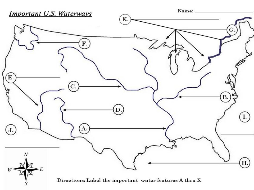
You have learned about the different geographical landforms of America. Each of these regions has different characteristics, and if you were to travel across the U.S. you would see beautiful coastlines, dense forests, wide prairies, thick grasslands, hot deserts, high cliffs, and different mountain ranges. For many years it was difficult to travel from one part of the country to another. Imagine living without cars, roads, trains, and airplanes! How would you travel? Many early explorers and settlers in America were faced with this tough challenge. Imagine walking or riding a horse through thick forests, up steep mountains, and through muddy grasslands. Because it was difficult to travel by land, early Americans looked for a different, better way. Oceans and rivers have played a key role in the history of our country. Today we often use cars and highways when we travel from one place to another, but in the past explorers and settlers traveling from Europe would board ships instead of planes. The early explorers to America came from Portugal, Spain, England, and France—which are all countries in Europe. These explorers would cross the Atlantic Ocean in search of gold and glory for their country. Some Europeans also wanted to spread the Christian religion. Later, settlers and immigrants used ships to cross the Atlantic Ocean to the new world. The Atlantic Ocean served as a highway for explorers, settlers, and immigrants. 1. Why did early explorers and settlers believe it was difficult to travel by land? 2. What countries did the early explorers to America come from? 3. List three reasons early explorers traveled to America. 4. The Atlantic Ocean served as a highway for _______________________, ______________________, and ______________________.

3
Atlantic Ocean

5
Called the highway for explorers and settlers and immigrants

6
Look at how many times Christopher Columbus crossed the Atlantic

7
Look at the amount of people who crossed the Atlantic, no wonder it is called a highway

8
On the west coast of American, along the Coastal Range, is the Pacific Ocean. This ocean was also used by early explorers. Some historians believe that Japanese and Chinese ships may have entered Pacific waters as early as 219 B.C. Europeans began exploring the Pacific Ocean during the 1500s, when Vasco Nunez de Balboa and Ferdinand Magellan led expeditions for Spain and Portugal. Magellan named this ocean “Pacifico” (which means peaceful), because during his voyage he experienced calm seas. Lewis and Clark wanted to reach the Pacific when they travelled across the United States. 1. Europeans began exploring the Pacific Ocean in the _________. 2. Who named the Pacific Ocean and how did it get its name? 3. What two explorers wanted to react the Pacific?
, because during his voyage he experienced calm seas. Lewis and Clark wanted to reach the Pacific when they travelled across the United States. 1. Europeans began exploring the Pacific Ocean in the _________. 2. Who named the Pacific Ocean and how did it get its name. 3. What two explorers wanted to react the Pacific .")
9
Pacific

11
Largest Ocean in the World!!!

12
Connects The United States to Asia!!- many immigrants came to the US

13
Early explorers like Lewis and Clark wanted to get to the Pacific Ocean

14
Another early exploration route was the Gulf of Mexico. Spanish explorers, such as Amerigo Vespucci, entered the gulf as early as 1497. In fact, a European mapmaker named our country America after Amerigo! Spanish conquistadors traveled through the gulf to reach Caribbean islands and Mexico, where they often enslaved native peoples and searched for gold. Spanish explorers were not the only ones to use the Gulf of Mexico as an exploration route. French explorers wanted to claim Louisiana because of its valuable river—the Mississippi. Which who countries explored the Gulf of Mexico? Where did Spanish conquistadors travel searching for gold?

15
Gulf of Mexico

17
The Spanish used the Gulf of Mexico to travel!!!

18
The French even came down to the Gulf of Mexico

19
The Gulf of Mexico gives you routes to Mexico and America

20
The of Mexico links up to the Mississippi River and is still used widely today!!

21
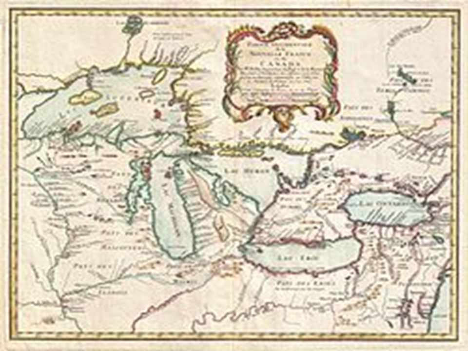
The Great Lakes is another important body of water. The Great Lakes are made up of five lakes; Huron, Ontario, Michigan, Erie, and Superior (HOMES). The French, such as Samuel De Champlain, first explored the Great Lakes. Along the Great Lakes you can find many large cities. Detroit, Chicago, Cleveland, Milwaukee, and Quebec are all cities located along the Great Lakes. They are connected to the Atlantic Ocean by the St. Lawrence River. A lot of boats travel up and down the Great Lakes! Who explored the Great Lakes? Name two cities along the Great Lakes. What travels up and down the Great Lakes?
. The French, such as Samuel De Champlain, first explored the Great Lakes. Along the Great Lakes you can find many large cities. Detroit, Chicago, Cleveland, Milwaukee, and Quebec are all cities located along the Great Lakes. They are connected to the Atlantic Ocean by the St. Lawrence River. A lot of boats travel up and down the Great Lakes. Who explored the Great Lakes. Name two cities along the Great Lakes. What travels up and down the Great Lakes .")
22
Great Lakes

24
HOMES

25
The great lakes are connected to each other and the Atlantic Ocean– many cities built there

26
Look at all the major cities!!– Detroit, Chicago, Cleveland, Milwaukee

27
The first city was built by Samuel Champlain-- Quebec

28
The Mississippi River is a valuable transportation route in the US. This river was formed during the most recent Ice Age, when glaciers melted and deposited rich soil to form the flat, fertile lands of the Mississippi River Valley. The Mississippi River is located in the Interior Lowlands, and this fertile land is great for farming. Barges, which are large boats, use the Mississippi River to carry farm equipment and products to the Gulf of Mexico. Early settlers relied on this river to transport goods since crossing the Appalachian Mountains east was long and hard. Some people call the Mississippi river a transportation artery. Arteries are large blood vessels that carry nutrients throughout our body. The Mississippi River is similar to an artery because it is a large river that is used to carry equipment and industrial products (tools and equipment) throughout America. What caused the flat, fertile lands of the Mississippi River Valley? The Mississippi River is located in the __________________________ region of the United States
 throughout America. What caused the flat, fertile lands of the Mississippi River Valley. The Mississippi River is located in the __________________________ region of the United States.")
29
Another transportation artery that carries farm equipment and goods is the Missouri River. The Missouri, nicknamed “Muddy River”, is the longest river in America. It begins in Montana and flows through the Great Plains south to the Mississippi. The first Europeans to explore this river were the French in the late 1600s. It became part of the United States when Thomas Jefferson purchased it from the French Emperor Napoleon in 1803 as part of the Louisiana Purchase. Lewis and Clark used it to explore! How are the Mississippi and Missouri Rivers similar to arteries? When did the Missouri River become part of the United States?

30
Mississippi River and Missouri River

32
Both are the two longest rivers in the United States--- they link the United states together!!

33
Because they are links, a lot of trade happens on both rivers!!!

34
Both are located in the Interior Lowlands--- one of the best places to farms

35
The Mississippi River was explored by the French explorer La Salle

36
Missouri explored by Lewis and Clark

37
A second tributary of the Mississippi River is the Ohio River. For thousands of years Native Americans used this river for transportation and trading. Later Robert de La Salle explored this river for the French. It is often referred to as the “Gateway to the West”, and served as a major transportation route for pioneers moving west. Why is the Ohio River referred to as the “Gateway to the West”?

38
Ohio River

40
Starts at Pittsburgh

41
Tributary of the Mississippi River

42
Called the gateway to the west cause it was the first river colonists wanted to get to to head west

43
The St. Lawrence River is also important in the United States. The St. Lawrence connects the Great Lakes to the Atlantic Ocean. The French explorers, Samuel De Champlain and Robert La Salle, first explored it. The St. Lawrence forms the border between the United States and Canada. The Native American tribe, the Iroquois would have made use of the St. Lawrence river. Who first explored the St. Lawrence? What does the St. Lawrence connect?

44
St. Lawrence River

46
The St. Lawrence connects great lakes to the Atlantic Ocean

47
THE FRENCH, like CHAMPLAIN and LASALLE sailed down the St. Lawrence

49
The Rio Grande River is also extremely important in the United States. The Rio Grande river is a tributary to the Gulf of Mexico. It forms the border between the United States and Mexico. During the exploration age, many Spanish conquistadors such as Francisco Coronado explored it. In Mexico, it is called Rio Bravo. Even the Pueblo tribe had different names for it such as Tewa. The Pueblo Indians used to Rio Grande to irrigate their farms. 1. What border does the Rio Grande form? What country explored the river? What tribe used the Rio Grande?

50
Rio Grande

52
Forms the border between US and MExico

53
Explored by Spanish conquistador Francisco Coronado

54
Tributary to the Gulf of Mexico

55
The Colorado River, located in the southwest, is one of the most important rivers in the United States history. Many Native American tribes such as the Pueblo used it for their farms. The Spanish then explored it, most famously by Francisco Coronado. The Colorado River has done many important things. It actually created the Grand Canyon and still today it provides water for almost 40 million people!!!! What country explored the Colorado River? What famous landmark did the Colorado River create?

56
Colorado River

58
Explored by the Spanish– Coronado (searching for the seven cities of gold)
")
59
Tributary to the Pacific Ocean

60
Forms the Grand Canyon

62
Used by the Pueblo Tribe to irrigate their crops

63
The last river that is important in the United States is the Columbia River. The Columbia River is located in the Pacific Northwest. It is a tributary to the Pacific Ocean. The Kwakiutl tribe, as a way to fish for salmon first used the Columbia River. Later it was explored by Lewis and Clark on their journey to the Pacific Ocean. What tribe used the Columbia River? Who explored the river to the Pacific Ocean?

64
Columbia River

66
In the Pacific Northwest- used by the Kwakiutl tribe

67
Explored by Lewis and Clark

68
Tributary to the Pacific Ocean

69
Great salmon fishing!!!

Similar presentations