Download presentation
Presentation is loading. Please wait.

1
RUSSIA & The REPUBLICS Chapter 15: RUSSIA & The REPUBLICS

2
The ________________________ stretches for over 1,000 miles between the western border of Russia & the ______________ and the _______________. One of the world’s most fertile soils—____________, or black earth—is abundant on the Northern European Plain. The ___________________ separate the Northern European and __________________ plains. East of the ___________ River lies the _________________________, a land dominated by _____________ and mountains. Towering mountains barren uplands and ________________________ are located in the southern areas of Russia & the Republics. In the southwest, the ___________________ stretch across the __________ separating the _________ & _________ Seas. Ural Mountains West Siberian chernozem Central Siberian Plateau Ch. 15:1 – Landforms & Resources Caucasus Mountains Northern European Plain Republics Ural Mountains Yenisey uplands semiarid grasslands isthmusBlackCaspian

3
These mountains form the ___________ between Russia & ______________ - a region consisting of the republics of ________________________________. Mountains are also located along the ___________________ border of Central Asia -- a region that includes ________________, _________________, _________________, __________________, and _______________. Some of the world’s ____________________ flow through the vast plains of Russia and the Republics. The ______________, the longest river in the region, drains into the __________________. In addition to some of the world’s longest rivers, Russia and the Republics also boast some of the largest _________ on Earth. _______________ is the ______________ and ____________ lake in the world. Transcaucasia KyrgyzstanKazakhstan UzebekistanTajikistanTurkmenistan Lake Baikal Volga River border Armenia, Azerbaijan, & Georgia southeastern longest rivers Caspian Sea deepest lakes oldest

4
Transcaucasia Central Asia

5
Volga River

6
Lake Baikal

7
Russia and the Republics have many ___________ and ______________ resources. Many of the region’s resources are located in ___________ and subarctic regions of_________________. Because of this, _______________ for oil and __________________, and mining for __________, gold, _____________, silver and other minerals is extremely difficult. energymineral frigid Siberia drilling natural gascoal diamonds

8
1. Much of Russia and the Republics are _______________________ from the moderating _____________ of the _________. The effect of this distance on climate is called____________________. 2. Temperatures in ____________ are so _____________________ that much is covered by a layer of permanently frozen ______ called__________________. 3. While _____________________ and _______________ climates dominate the northern & ___________ areas of the region, Russia and the Republics also have warmer climates. In__________________, moist air from the _________________________ contributes to a ________________ climate zone in the region. hundreds of miles Transcaucasia permafrost Ch. 15:2 – Climate & Vegetation influencesea continentality Siberiaconsistently low soil humid continentalsubarctic eastern Mediterranean Sea subtropical

9
Permafrost Landscape

10
Arctic Permafrost Landscape

11
Map of Transcaucasia

12
4. Russia and the Republics have _________________________ regions. The _________ region falls mostly in the __________________ zone. 5. South of this region lies the _______________ on Earth—the_________. 6. The__________ is the name of the _______________________ that extends from ___________________ through _______________________ to the _________________. 7. The two main ____________ that occupy wide plains in the ________ and __________ areas of Central Asia are the____________ & the____________. tundra steppe taiga Kara Kum Kyzyl Kum four major vegetation arctic climate largest forest temperate grassland southern Ukrainenorthern Kazakhstan Altay Mountains desertswest central

13
Tundra

14
Tundra Yukagir Reindeer Herders

15
Taiga

16
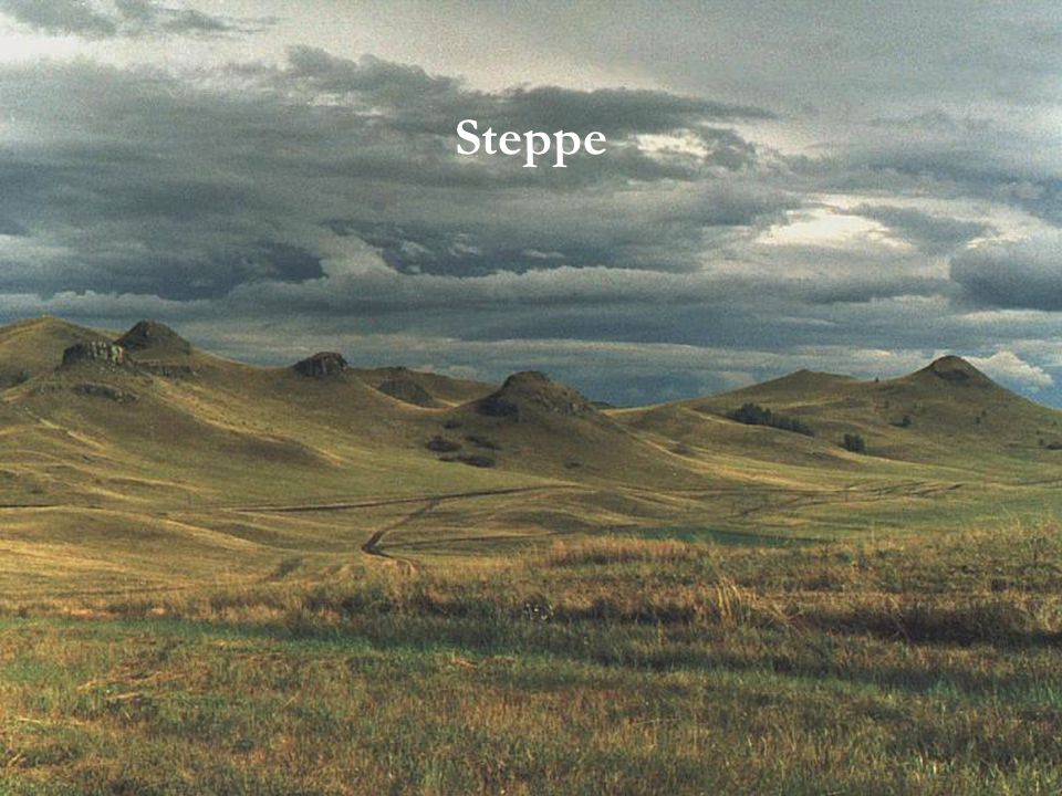
Steppe

18
Kara Kum Desert

19
Kyzyl Kum Desert

20
1. Between 1960 and the present, the__________ lost about ________of its ________. 2. The flow of water into the _______ was _____________ because of _____________. 3. The sea’s shrinking ___________ exposed ____________ and _____________, as well as salt. ________________ began to pick up these ___________— at rates as high as __________________ per year— and ___________ them on nearby ______________. 4. This ____________ has caused a sharp increase in ____________. Aral Sea Windstorms Ch. 15:3 – Human-Environment Interaction reduced 80% water sea irrigation shorefertilizers pesticides residues44 million tons dumpedpopulations pollution disease

21
The Environmental Disaster of the Aral Sea

22
Location

23
Satellite Image of the Aral Sea

24
Why is the Aral Sea important? It was once the fourth largest inland body of water on earth It provided rich fishing resources It is an example of Soviet misuse of the environment Fishing once employed many thousands; unemployment is at about 40% today.

25
What started the Aral Sea problem? In the 1950s, the U.S.S.R. wanted to grow cotton in the deserts of Central Asia They needed to irrigate the land by using nearby rivers

26
How was the Aral Sea affected? The Amu Darya and the Syr Darya were a source of irrigation water These rivers feed into the Aral Sea The Aral has greatly shrunk Amu Darya River today is a mere trickle.

27
The Damage Over Time:

28
Ships stranded due to the lack of water

29
Due to the shrinking of the Aral Sea, fishing boats have been stranded in what was once water.

30
Fish: A Rare Sight in the Aral Sea Region

31
Other Environmental Problems: Cotton cultivation requires the use of pesticides and fertilizers The use of these agents in the Aral Sea region have caused huge health problems Around 70% of women suffer from anemia and the death rate in childbirth is high.

32
Camels are a common means of transport in the Aral Sea region.

33
Dogsled Team in Siberia

34
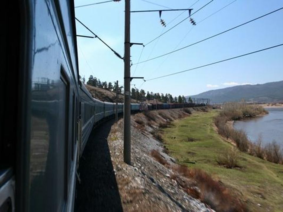
The Trans-Siberian Railroad is the longest continuous rail line on earth, spanning nearly 6,000 miles.

35
The Trans-Siberian Railroad

37
A Painting of French Soldiers Freezing During Napoleon’s Unsuccessful Attack of Russia - 1812

38
5. The rugged inhabitants of ___________are also familiar with hard- ship. In this region, _________________ have reached ________ below zero. 6. The ___________ affects ______________ in Siberia. As the ground __________ buildings ______, tilt, and eventually _________ over. 7. Russia’s harsh __________ has sometimes come to the aid of the region’s _____________. Some assert that Russia’s ________________ succeeded in defeating the French leader____________________ and his troops where the other armies of __________ had _________ to defeat him. 8. The_______________________ is a massive human-environment interaction that covers over ______________ and crosses __________________. climate Trans-Siberian Railway Napoleon Bonaparte construction thawssinktopple winter inhabitants“General Winter” Siberia temperatures90ºF Europefailed 5,700 miles7 time zones

Similar presentations


 of the U.S. / 11 times zones/ nearly 1/6.>")


