Download presentation
Presentation is loading. Please wait.

1
WJEC GCSE Geography A Unit 1 – The Core A- The Physical World Theme 1 Water

2
1What are river processes and what landforms do they create? 1.1What processes are associated with rivers? 1.2What landforms result from these processes? 1.3How do these landforms and processes affect the lives of people living along rivers? 2How should rivers be managed? 2.1How successful are different management approaches to the problems of flooding? 2.2Should we change our approach to river and floodplain management in the future?

3
Theme 1 Water 1 What are river processes and what landforms do they create?

4
1.1What processes are associated with rivers? Before looking at the processes associated with rivers, we must understand that rivers operate within a drainage basin system. A drainage basin (or river basin) is an area of A drainage basin (or river basin) is an area of land drained by a main river and its tributaries. Tributaries are streams or rivers which flow into Tributaries are streams or rivers which flow into another, usually larger, stream or river.
 is an area of A drainage basin (or river basin) is an area of land drained by a main river and its tributaries. Tributaries are streams or rivers which flow into Tributaries are streams or rivers which flow into another, usually larger, stream or river..")
5
Drainage basins The boundary of the drainage basin is called a watershed. It is usually marked by a ridge of higher land. The boundary of the drainage basin is called a watershed. It is usually marked by a ridge of higher land. Where a stream begins is called the source. Where a stream begins is called the source. Where a river enters the sea (or lake) is called the mouth. Wide river mouths are called estuaries. Where a river enters the sea (or lake) is called the mouth. Wide river mouths are called estuaries.
 is called the mouth. Wide river mouths are called estuaries. Where a river enters the sea (or lake) is called the mouth. Wide river mouths are called estuaries..")
6
Drainage basins When one stream or river joins another or meet is called a confluence. When one stream or river joins another or meet is called a confluence.

7
Drainage basin system A drainage basin forms part of the hydrological cycle. A drainage basin forms part of the hydrological cycle. It is an open system with inputs and outputs. It is an open system with inputs and outputs. Within the system are stores and transfers (or flows). Within the system are stores and transfers (or flows).
. Within the system are stores and transfers (or flows)..")
9
1.1What processes are associated with rivers? A river needs energy and most of a river’s energy (95% under normal conditions) goes to overcome friction. The channel of a mountain stream which is full of boulders creates a lot of friction and the water flows slowly. The channel in lower ground is wider and deeper and has less friction so the water moves faster.
 goes to overcome friction. The channel of a mountain stream which is full of boulders creates a lot of friction and the water flows slowly. The channel in lower ground is wider and deeper and has less friction so the water moves faster..")
10
Transportation When the volume of water in a river increases, friction is reduced and the river’s surplus energy can be used to pick up and transport material. Material transported by a river is called its load. When the volume of water in a river increases, friction is reduced and the river’s surplus energy can be used to pick up and transport material. Material transported by a river is called its load. A river can transport its load by one of four processes: A river can transport its load by one of four processes:

11
Transportation TRACTION = when stones roll along the river bed (this needs the most energy). TRACTION = when stones roll along the river bed (this needs the most energy). SALTATION = when sand-sized particles bounce along the river bed in a ‘leap-frog’ movement. SALTATION = when sand-sized particles bounce along the river bed in a ‘leap-frog’ movement. SUSPENSION = silt and clay-sized particles are carried within the water flow. SUSPENSION = silt and clay-sized particles are carried within the water flow. SOLUTION = when some minerals dissolve in the water (this needs the least energy). SOLUTION = when some minerals dissolve in the water (this needs the least energy).
. SALTATION = when sand-sized particles bounce along the river bed in a ‘leap-frog’ movement. SALTATION = when sand-sized particles bounce along the river bed in a ‘leap-frog’ movement. SUSPENSION = silt and clay-sized particles are carried within the water flow. SUSPENSION = silt and clay-sized particles are carried within the water flow. SOLUTION = when some minerals dissolve in the water (this needs the least energy). SOLUTION = when some minerals dissolve in the water (this needs the least energy)..")
13
Erosion A river uses the transported material to erode its banks and bed. As the velocity of a river increases, so too does the load it can carry and the rate at which it can erode. There are four processes of erosion:

14
Erosion ATTRITION = when material carried by the river collide and break up into smaller pieces (more likely in highland areas) ATTRITION = when material carried by the river collide and break up into smaller pieces (more likely in highland areas) HYDRAULIC ACTION = the sheer force of the water dislodging particles from the river’s banks and bed. HYDRAULIC ACTION = the sheer force of the water dislodging particles from the river’s banks and bed. CORRASION (ABRASION) = when small material rubs against the banks of the river (more likely in lowland areas). CORRASION (ABRASION) = when small material rubs against the banks of the river (more likely in lowland areas). CORROSION = when acids in the water dissolve rocks such as limestone. CORROSION = when acids in the water dissolve rocks such as limestone.
 = when small material rubs against the banks of the river (more likely in lowland areas). CORRASION (ABRASION) = when small material rubs against the banks of the river (more likely in lowland areas). CORROSION = when acids in the water dissolve rocks such as limestone. CORROSION = when acids in the water dissolve rocks such as limestone..")
15
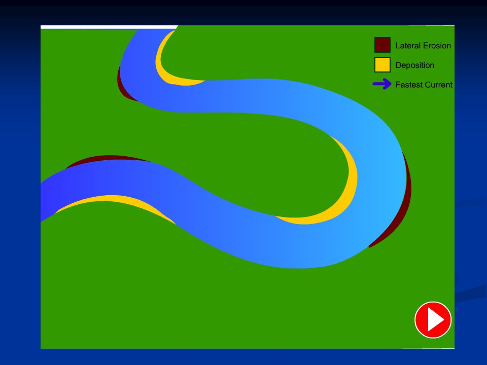
Deposition Deposition occurs when a river lacks enough energy to carry its load. The heaviest material is deposited first. Deposition can occur when the river level drops (following a dry spell, for example) or where the current slows down (on the inside of a meander, for example).
 or where the current slows down (on the inside of a meander, for example)..")
16
1.2 What landforms result from these processes? A landform is a physical feature on the earth’s surface. A landform is a physical feature on the earth’s surface. They are created due to erosion, transportation and deposition of material. They are created due to erosion, transportation and deposition of material. Other factors that affect the creation of river landforms are rock type and rock structure. Other factors that affect the creation of river landforms are rock type and rock structure. They are different in highland areas and lowland areas. They are different in highland areas and lowland areas.

17
River landforms in a highland area Waterfalls and gorges Waterfalls and gorges

19
River landforms in a lowland area Meanders and ox-bow lakes. Meanders and ox-bow lakes. Floodplains and levees. Floodplains and levees.

22
1.3 How do these landforms and processes affect the lives of people living along rivers? Many people all around the world live near rivers. Living near a river can give many benefits but can also have drawbacks. Many people all around the world live near rivers. Living near a river can give many benefits but can also have drawbacks.Task Sort the following statements into the correct column in the table:

23
Benefits of living near a river Drawbacks of living near a river floods high water levels good farmland flat land building materials changing river channels silting water supply easy travel effluent and sewage disposal leisure activities better weather nature tourism

24
Flooding A flood is when land not usually covered in water becomes covered in water. There is too much water for the river channel to hold. A flood is when land not usually covered in water becomes covered in water. There is too much water for the river channel to hold.

25
River discharge Discharge is the amount of water in the river passing a certain point (gauging station) at a given time. Discharge is the amount of water in the river passing a certain point (gauging station) at a given time. Discharge is measured in cubic metres per second (m 3 /s) – also called cumecs. Discharge is measured in cubic metres per second (m 3 /s) – also called cumecs. It is calculated by using the formula: It is calculated by using the formula: DISCHARGE = VELOCITY X CROSS- SECTIONAL AREA OF CHANNEL Velocity = the speed of the river in metres per second (m/s) The cross-sectional area = width x depth of the river channel [in square metres (m 2 )].
 at a given time. Discharge is measured in cubic metres per second (m 3 /s) – also called cumecs. Discharge is measured in cubic metres per second (m 3 /s) – also called cumecs. It is calculated by using the formula: It is calculated by using the formula: DISCHARGE = VELOCITY X CROSS- SECTIONAL AREA OF CHANNEL Velocity = the speed of the river in metres per second (m/s) The cross-sectional area = width x depth of the river channel [in square metres (m 2 )]..")
26
A flood hydrograph The first water to reach the river will be surface runoff. The first water to reach the river will be surface runoff. Later in the storm there will be more throughflow. Later in the storm there will be more throughflow. The gap between peak rainfall and peak discharge is called lag time. The gap between peak rainfall and peak discharge is called lag time.

27
The flood hydrograph A hydrograph is a graph showing the discharge of a river at a given point over a period of time. A hydrograph is a graph showing the discharge of a river at a given point over a period of time. A flood (or storm) hydrograph shows how a river responds to one storm. A flood (or storm) hydrograph shows how a river responds to one storm.
 hydrograph shows how a river responds to one storm. A flood (or storm) hydrograph shows how a river responds to one storm..")
28
Factors affecting the shape of the flood hydrograph Relief Relief Rock type; Rock type; Soil; Soil; Vegetation; Vegetation; Land use; Land use; How much use is made of the river; How much use is made of the river; Drainage density. Drainage density. Task Explain how each of the factors listed above affect the shape of a hydrograph. You may find drawing a diagram (or diagrams) will help you.
 will help you..")
29
What causes flooding? Flooding happens when water moves quickly into a river. This could be due to: A prolonged period of heavy rain (and saturated land); A prolonged period of heavy rain (and saturated land); A storm; A storm; Melting snow; Melting snow; Steep valley sides; Steep valley sides; Impermeable bedrock (does not let water through); Impermeable bedrock (does not let water through); Thin soils; Thin soils; Lack of vegetation; Lack of vegetation; Urbanisation; Urbanisation; Silting of the river channel. Silting of the river channel.
; A prolonged period of heavy rain (and saturated land); A storm; A storm; Melting snow; Melting snow; Steep valley sides; Steep valley sides; Impermeable bedrock (does not let water through); Impermeable bedrock (does not let water through); Thin soils; Thin soils; Lack of vegetation; Lack of vegetation; Urbanisation; Urbanisation; Silting of the river channel. Silting of the river channel..")
30
Flooding Do remember that flooding is a natural process. Do remember that flooding is a natural process. Flooding is made more serious by the actions of people Flooding is made more serious by the actions of people

31
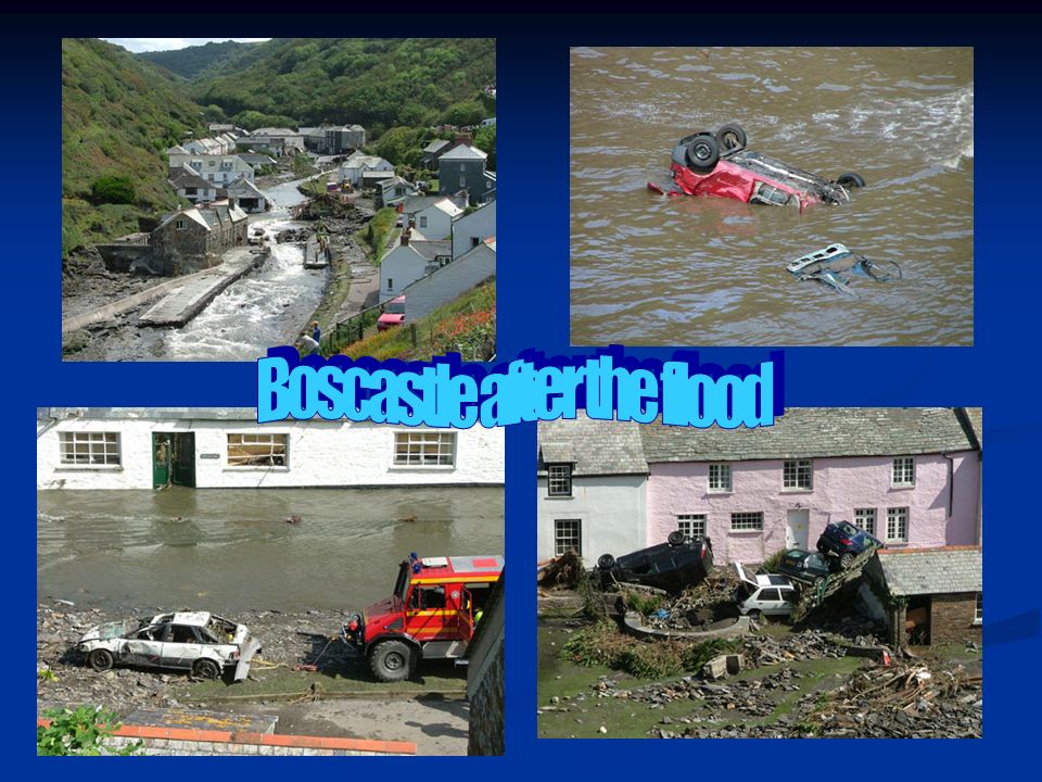
Example: Boscastle Floods Flooding happened in the area of Boscastle, Devon in August 2004. Do some research into this flood event and prepare a written report on it. Include maps, diagrams and photographs if you wish. You should include: Where is Boscastle and what happened there (briefly); Where is Boscastle and what happened there (briefly); What factors were responsible for the flooding? What factors were responsible for the flooding? What were the impacts of the flooding? You should mention What were the impacts of the flooding? You should mention physical impacts (e.g. on land) demographic impacts (e.g. deaths) economic impacts (e.g. how much money it cost) social impacts (the effects on daily life). What has been done to stop this type of flood from happening again? What has been done to stop this type of flood from happening again?
; Where is Boscastle and what happened there (briefly); What factors were responsible for the flooding. What factors were responsible for the flooding. What were the impacts of the flooding. You should mention What were the impacts of the flooding. You should mention physical impacts (e.g. on land) demographic impacts (e.g. deaths) economic impacts (e.g. how much money it cost) social impacts (the effects on daily life). What has been done to stop this type of flood from happening again. What has been done to stop this type of flood from happening again .")
32
Boscastle Floods – Useful Websites www.bbc.co.uk (good for articles and photographs) www.bbc.co.uk (good for articles and photographs) www.bbc.co.uk www.wikipedia.org www.wikipedia.org www.google.co.uk (good for images and to find other useful websites). www.google.co.uk (good for images and to find other useful websites). www.google.co.uk www.metoffice.gov.uk/education/teens/casestu dy_boscastle.html www.metoffice.gov.uk/education/teens/casestu dy_boscastle.html www.metoffice.gov.uk/education/teens/casestu dy_boscastle.html www.metoffice.gov.uk/education/teens/casestu dy_boscastle.html www.ordnancesurvey.co.uk/getamap www.ordnancesurvey.co.uk/getamap
. dy_boscastle.html dy_boscastle.html dy_boscastle.html dy_boscastle.html")
Similar presentations


 _________ 3) _________>")
