Download presentation
Presentation is loading. Please wait.

1
Scientific Roadmap towards Height System Unification with GOCE 5th International GOCE User Workshop, Paris, 27.11.2014 Th. Gruber (1), R. Rummel (1), M. Sideris (2), E. Rangelova (2), P. Woodworth (3), C. Hughes (3), J. Ihde (4), G. Liebsch (4), A. Rülke (4), Ch. Gerlach (5), R. Haagmans (6) (1) Institute for Astronomical and Physical Geodesy, Technical University Munich, Germany (2) Department of Geomatics Engineering, University of Calgary, Canada (3) National Oceanography Centre, Liverpool, United Kingdom (4) Bundesamt für Kartographie und Geodäsie (BKG), Frankfurt/Main, Germany (5) Kommission für Erdmessung und Glaziologie, Bayerische Akademie der Wissenschaften, Munich Germany (6) European Space Agency, The European Space Research and Technology Centre, Noordwijk, The Netherlands ESA Project: Support to Science Element (STSE) GOCE+ Theme 1: Height System Unification (HSU)
, R. Rummel (1), M. Sideris (2), E. Rangelova (2), P. Woodworth (3), C. Hughes (3), J. Ihde (4), G. Liebsch (4), A. Rülke (4), Ch. Gerlach (5), R. Haagmans (6) (1) Institute for Astronomical and Physical Geodesy, Technical University Munich, Germany (2) Department of Geomatics Engineering, University of Calgary, Canada (3) National Oceanography Centre, Liverpool, United Kingdom (4) Bundesamt für Kartographie und Geodäsie (BKG), Frankfurt/Main, Germany (5) Kommission für Erdmessung und Glaziologie, Bayerische Akademie der Wissenschaften, Munich Germany (6) European Space Agency, The European Space Research and Technology Centre, Noordwijk, The Netherlands ESA Project: Support to Science Element (STSE) GOCE+ Theme 1: Height System Unification (HSU).")
2
5th International GOCE User Workshop, Paris, 27.11.2014 Outline Upper-Rhine Bridge; Germany – Switzerland: 27 cm height offset applied with wrong sign Problem Overview Essential Tasks (Scientific Roadmap) Diagnosis of Height Systems Global Height System Unification Ocean Levelling GNSS/Levelling in well surveyed Land Areas GNSS/Levelling in sparsely surveyed Land Areas Conclusions
 Diagnosis of Height Systems Global Height System Unification Ocean Levelling GNSS/Levelling in well surveyed Land Areas GNSS/Levelling in sparsely surveyed Land Areas Conclusions")
3
5th International GOCE User Workshop, Paris, 27.11.2014 GOCE Equipotential Surface (long wavelengths) Local Vertical Datum (Equipotential Surface) Local Physical Height True Equipotential Surface (short wavelengths) Local Geoid Height GOCE Physical Height Omission Error Problem Overview Vertical Datum A Vertical Datum C A C B Vertical Datum B GPS Benchmarks Tide Gauge Benchmark Levelling Network GOCE Geoid Height
 Local Vertical Datum (Equipotential Surface) Local Physical Height True Equipotential Surface (short wavelengths) Local Geoid Height GOCE Physical Height Omission Error Problem Overview Vertical Datum A Vertical Datum C A C B Vertical Datum B GPS Benchmarks Tide Gauge Benchmark Levelling Network GOCE Geoid Height")
4
5th International GOCE User Workshop, Paris, 27.11.2014 Scientific Roadmap – Essential Tasks The geopotential and geoid improvements resulting from GOCE are the basis of a reassessment of global height systems Diagnosis of existing height systems by comparison with GOCE geoid

5
5th International GOCE User Workshop, Paris, 27.11.2014 Scientific Roadmap – Diagnosis of Height Systems Diagnosis of existing Height Systems by Comparison of GPS/Levelling with GOCE Geoid Reference: Long-wavelength errors of the US vertical datum (Wang et al., 2012) Australian GPS/Levelling vs. GOCE-TIM5 GeoidUS GPS/Levelling vs. GOCE-TIM5 Geoid Canadian GPS/Levelling vs. GOCE-TIM5 Geoid

6
5th International GOCE User Workshop, Paris, 27.11.2014 Scientific Roadmap – Diagnosis of Height Systems Diagnosis of existing Height Systems by Comparison of GPS/Levelling with GOCE-TIM5 Geoid for some European Countries France UK Germany Italy Netherlands 40 cm 30 cm 25 cm 40 cm 5 cm

7
5th International GOCE User Workshop, Paris, 27.11.2014 GOCE Equipotential Surface (long wavelengths) Vertical Datum A Vertical Datum C A C B Vertical Datum B GPS Benchmarks Tide Gauge Benchmark Levelling Network Regional Height Reference Surface (Geoid?) Scientific Roadmap – Diagnosis of Height Systems GOCE Physical Height Regional Height
 Vertical Datum A Vertical Datum C A C B Vertical Datum B GPS Benchmarks Tide Gauge Benchmark Levelling Network Regional Height Reference Surface (Geoid ) Scientific Roadmap – Diagnosis of Height Systems GOCE Physical Height Regional Height")
8
5th International GOCE User Workshop, Paris, 27.11.2014 Scientific Roadmap – Diagnosis of Height Systems Diagnosis of existing Height Systems by Comparison of GPS/Levelling with GOCE-TIM5 - before and after subtracting a regional Correction Surface GPS-Lev. Geoid Differences Correction Surface Residual Differences What causes these systematic differences: GOCE geoid, Levelling or GPS Heights? GOCE geoid error is below 2 cm globally – cannot be the reason. Levelling is sensitive to systematic distortions – most likely the main reason. Observation GPS height error 1-2 cm randomly distributed – cannot be the reason. But what about the coordinate frames?

9
5th International GOCE User Workshop, Paris, 27.11.2014 Scientific Roadmap – Diagnosis of Height Systems Impact of Coordinate Frame Transformations on GPS Heights (Study performed by G. Liebsch, BKG) GPS and geoid heights need to be in a consistent frame. GOCE geoid heights refer to CoM. GPS heights refer to an ITRFxxxx with a center of origin which is not consistent to CoM. ITRF2008 is known to be close to CoM. ITRF1989 (ETRF1989) to ITRF2008 offset is (x,y,z): 2.8 - 3.9 - 10.1 cm 7 parameter Helmert transformation (plus linear trends) result in height change of up to 7 cm in Europe (see figure). When GPS and GOCE geoid heights are jointly used in GPS-Levelling this needs to be taken into account.
 GPS and geoid heights need to be in a consistent frame. GOCE geoid heights refer to CoM. GPS heights refer to an ITRFxxxx with a center of origin which is not consistent to CoM. ITRF2008 is known to be close to CoM. ITRF1989 (ETRF1989) to ITRF2008 offset is (x,y,z): cm 7 parameter Helmert transformation (plus linear trends) result in height change of up to 7 cm in Europe (see figure). When GPS and GOCE geoid heights are jointly used in GPS-Levelling this needs to be taken into account..")
10
5th International GOCE User Workshop, Paris, 27.11.2014 Scientific Roadmap – Essential Tasks The geopotential and geoid improvements resulting from GOCE are the basis of a reassessment of global height systems Realization of a globally unified height system but confined to a global set of primary stations (national datum points, fundamental stations, primary tide gauges, primary clocks). Global Height System Unification Diagnosis of existing height systems by comparison with GOCE geoid (100 km)
.")
11
5th International GOCE User Workshop, Paris, 27.11.2014 Scientific Roadmap – Global Height System Unification Observed Geoid Height referring to vertical Datum A Geoid Height Offset of vertical Datum A wrt. “mean” Geoid. Geoid height from GOCE model Residual geoid height (omission) Observation Equation from spirit levelling referring to height datum A (e.g. tide gauge) from GNSS positioning referring to a specific ellipsoid Computed Geoid Height referring to “mean” Geoid Geoid Height System Offset wrt. Geoid
 Observation Equation from spirit levelling referring to height datum A (e.g. tide gauge) from GNSS positioning referring to a specific ellipsoid Computed Geoid Height referring to mean Geoid Geoid Height System Offset wrt. Geoid.")
12
5th International GOCE User Workshop, Paris, 27.11.2014 Scientific Roadmap – Global Height System Unification per degree from degree (to infinity) Omission error can be estimated from EGM2008 and/or residual terrain modelling Omission Error
 Omission error can be estimated from EGM2008 and/or residual terrain modelling Omission Error")
13
5th International GOCE User Workshop, Paris, 27.11.2014 Scientific Roadmap – Global Height System Unification GOCE –TIM5 Model truncated at D/O 200

14
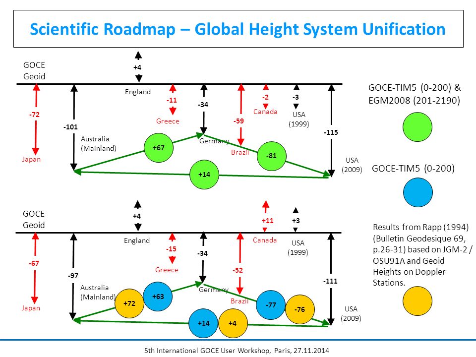
5th International GOCE User Workshop, Paris, 27.11.2014 Scientific Roadmap – Global Height System Unification GOCE Geoid Australia (Mainland) -101 England -34 Germany -3 -115 USA (1999) USA (2009) -11 Greece -72 Japan -2 Canada -59 Brazil +67 -81 +14 GOCE-TIM5 (0-200) & EGM2008 (201-2190) +4 GOCE Geoid Australia (Mainland) -97 England -34 Germany +3+3 -111 USA (1999) USA (2009) -15 Greece -67 Japan +11 Canada -52 Brazil +63 -77 +14 +4 GOCE-TIM5 (0-200) Results from Rapp (1994) (Bulletin Geodesique 69, p.26-31) based on JGM-2 / OSU91A and Geoid Heights on Doppler Stations. -76 +4 +72
15
5th International GOCE User Workshop, Paris, 27.11.2014 Scientific Roadmap – Essential Tasks The geopotential and geoid improvements resulting from GOCE are the basis of a reassessment of global height systems Realization of a globally unified height system but confined to a global set of primary stations (national datum points, fundamental stations, primary tide gauges, primary clocks). Open Oceans and Coastal Zones Global Height System Unification Diagnosis of existing height systems by comparison with GOCE geoid (100 km) Realization of a globally consistent model of mean dynamic ocean topography at tide gauges and at sea (Ocean Levelling).
 Realization of a globally consistent model of mean dynamic ocean topography at tide gauges and at sea (Ocean Levelling)..")
16
5th International GOCE User Workshop, Paris, 27.11.2014 Scientific Roadmap – Ocean Levelling Sea level slope at tide gauges along the east coast of North America from classical geodetic leveling (top: USA in red, Canada in blue), from an ocean circulation model (black) and from GNSS-Levelling based on GOCE DIR5 & EGM2008 (bottom: red & blue) (Study performed by Phil Woodworth, NOC)
, from an ocean circulation model (black) and from GNSS-Levelling based on GOCE DIR5 & EGM2008 (bottom: red & blue) (Study performed by Phil Woodworth, NOC)")
17
5th International GOCE User Workshop, Paris, 27.11.2014 Scientific Roadmap – Essential Tasks The geopotential and geoid improvements resulting from GOCE are the basis of a reassessment of global height systems Realization of a globally unified height system but confined to a global set of primary stations (national datum points, fundamental stations, primary tide gauges, primary clocks). Open Oceans and Coastal Zones Global Height System Unification Well Surveyed Areas (Land) Diagnosis of existing height systems by comparison with GOCE geoid (100 km) Realization of a globally consistent model of mean dynamic ocean topography at tide gauges and at sea. Regional geoid based on GOCE model. Establishment of national or regional height systems at primary points (first and second order) based on the technique of “GNSS-leveling”.
 Diagnosis of existing height systems by comparison with GOCE geoid (100 km) Realization of a globally consistent model of mean dynamic ocean topography at tide gauges and at sea. Regional geoid based on GOCE model. Establishment of national or regional height systems at primary points (first and second order) based on the technique of GNSS-leveling ..")
18
5th International GOCE User Workshop, Paris, 27.11.2014 Scientific Roadmap – Well Surveyed Areas GOCE Equipotential Surface (long wavelengths) True Equipotential Surface (short wavelengths) True Geoid Height GNSS Receiver GOCE Geoid Height h N GOCE N Assumptions: (1)Network of permanent, high quality GNSS stations. Observation of h (2)GOCE geopotential/geoid model. Determination of N GOCE (3)Regional gravity and topographic data. (4)Refined GOCE geoid model leading to a regional geoid. Determination of N (5)Consistent reference frames for h and N GOCE / N H H = h - N H = h - N GOCE Omission Error = N - N GOCE
GOCE geopotential/geoid model. Determination of N GOCE (3)Regional gravity and topographic data. (4)Refined GOCE geoid model leading to a regional geoid. Determination of N (5)Consistent reference frames for h and N GOCE / N H H = h - N H = h - N GOCE Omission Error = N - N GOCE.")
19
5th International GOCE User Workshop, Paris, 27.11.2014 Mean Differences of GOCE TIM5 and GPS-Levelling Geoid Heights & Omission Error from EGM2008 from D/O 181 to 2190 with omission error (signal) w/o omission error (signal) -1.221 -3.729 +0.422 -0.840 Guam +0.493 -0.605 Marianas Samoa Guam & Marianas Scientific Roadmap – Well Surveyed Areas
 w/o omission error (signal) Guam Marianas Samoa Guam & Marianas Scientific Roadmap – Well Surveyed Areas")
20
5th International GOCE User Workshop, Paris, 27.11.2014 Scientific Roadmap – Essential Tasks The geopotential and geoid improvements resulting from GOCE are the basis of a reassessment of global height systems Realization of a globally unified height system but confined to a global set of primary stations (national datum points, fundamental stations, primary tide gauges, primary clocks). Open Oceans and Coastal Zones Global Height System Unification Well Surveyed Areas (Land) Sparsely Surveyed Areas (Land) Diagnosis of existing height systems by comparison with GOCE geoid (100 km) Realization of a globally consistent model of mean dynamic ocean topography at tide gauges and at sea. Establishment of national or regional height systems at primary points (first and second order) based on the technique of “GNSS-leveling”. Establishment of a master plan: realization of datum point first-order GNSS reference points diagnosis of regional gravity and/or leveling and/or topographic data base
 Sparsely Surveyed Areas (Land) Diagnosis of existing height systems by comparison with GOCE geoid (100 km) Realization of a globally consistent model of mean dynamic ocean topography at tide gauges and at sea. Establishment of national or regional height systems at primary points (first and second order) based on the technique of GNSS-leveling . Establishment of a master plan: realization of datum point first-order GNSS reference points diagnosis of regional gravity and/or leveling and/or topographic data base.")
21
5th International GOCE User Workshop, Paris, 27.11.2014 Scientific Roadmap – Sparsely Surveyed Areas Model Equipotential Surface Model Geoid Height GNSS Receiver h N Model H Height of Mount Everest: h = 8821.47 m (average from GPS and classical techniques for snow surface) (Chen, J. et al, 2006, Science in China; doi: 10.1007/s11430-006-0531-1 N GOCE = -26.58 m N EGM = -22.90 m (GOCE-TIM5 d/o 280) (EGM2008 d/o 2190) this leads to heights above sea level: H GOCE = 8848.05 m H EGM = 8844.37 m Ellipsoidal Height Height above Sea Level Large uncertainty in omission error estimate due to lack of gravimetric data. N GOCE/EGM = -22.19 m (GOCE-TIM5 d/o 200 & EGM2008 d/o 201-2190) Model geoid height for H=0 Model geoid height from height anomaly and correction terms (c.f. Rapp, 1997, JoG). N EGM/Rapp = -28.50 m (EGM2008 d/o 2190) H EGM/Rapp = 8849.97 m H Chen = 8847.93 m (based on local geoid)
 (EGM2008 d/o 2190) this leads to heights above sea level: H GOCE = m H EGM = m Ellipsoidal Height Height above Sea Level Large uncertainty in omission error estimate due to lack of gravimetric data. N GOCE/EGM = m (GOCE-TIM5 d/o 200 & EGM2008 d/o ) Model geoid height for H=0 Model geoid height from height anomaly and correction terms (c.f. Rapp, 1997, JoG). N EGM/Rapp = m (EGM2008 d/o 2190) H EGM/Rapp = m H Chen = m (based on local geoid).")
22
5th International GOCE User Workshop, Paris, 27.11.2014 Conclusions The GOCE geoid represents a reference for global and regional height systems with unprecedented spatial resolution. GOCE enables the diagnosis of systematic distortions in existing height systems. GOCE enables global height system unification if the omission error at height reference stations can be quantified. The GOCE geoid supports results obtained from ocean models at tide gauges. GOCE supports GNSS/Levelling. In well surveyed areas a GOCE based regional geoid and consistent reference frames shall be used. In sparsely surveyed areas the GOCE geoid in many cases represents the best possible reference surface. Data for regional geoid modelling have to be acquired.

23
5th International GOCE User Workshop, Paris, 27.11.2014 Final Remark Project results are available at the following web-site: http://www.goceplushsu.eu

Similar presentations


 and the Defense Mapping School Reviewed by:____________ Date:_________ Objective:>")

, Technische Universität.>")


>")

, M.Eng. (Survey) Topcon Instruments (Thailand) Co.,Ltd. Tel. 08-1821-1297 Satellite Surveying.>")

