Download presentation
Presentation is loading. Please wait.

1
World Geography Physical Geography

2
Maps Concepts Scale Latitude Longitude Relative Location Orientation

3
Geographers Use GIS Field Work Satellite Image Photographs Maps, Globes Data Bases Primary Sources

4
Latitude: absolute location

5
Longitude: absolute location

6
Relative Location Describes the spatial relationships between and among places.

7
Area Can be represented using a variety of scales.

8
Scale The amount of detail shown on a map is dependent on the scale used.

9
Compass Rose Directional Indicator-identifies map orientation

10
Mental Maps: based on objective knowledge and subjective perceptions. Carry out daily activities Give directions to others Understand world events

11
Mental Maps Serve as indicator of how well people know the spatial characteristics of certain places.

12
Map Is a visual representation of geographic information All Maps are distorted representations of Earth’s Surface

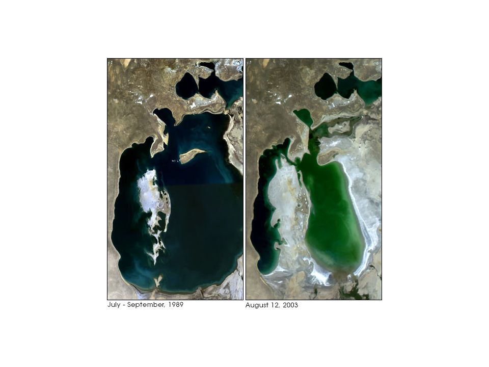
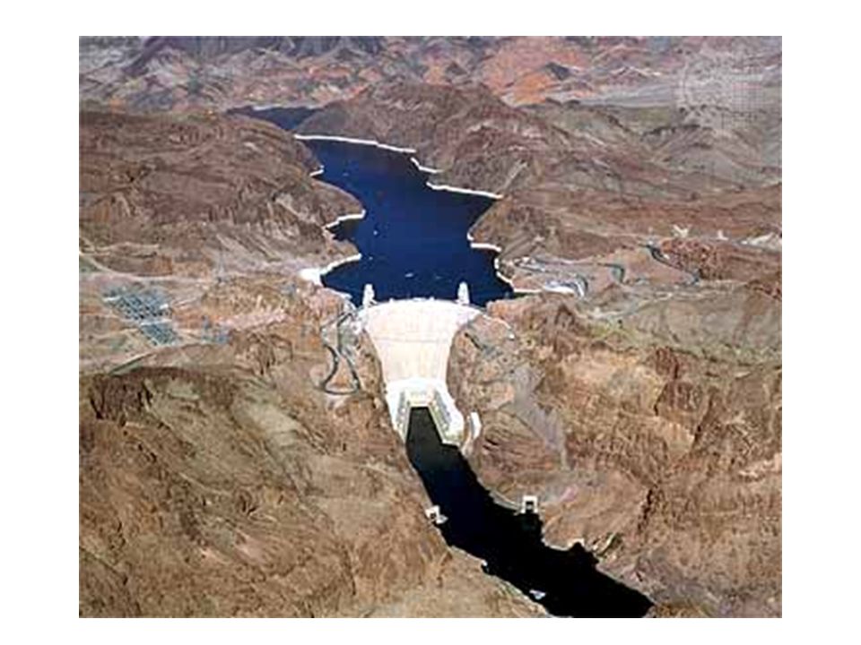
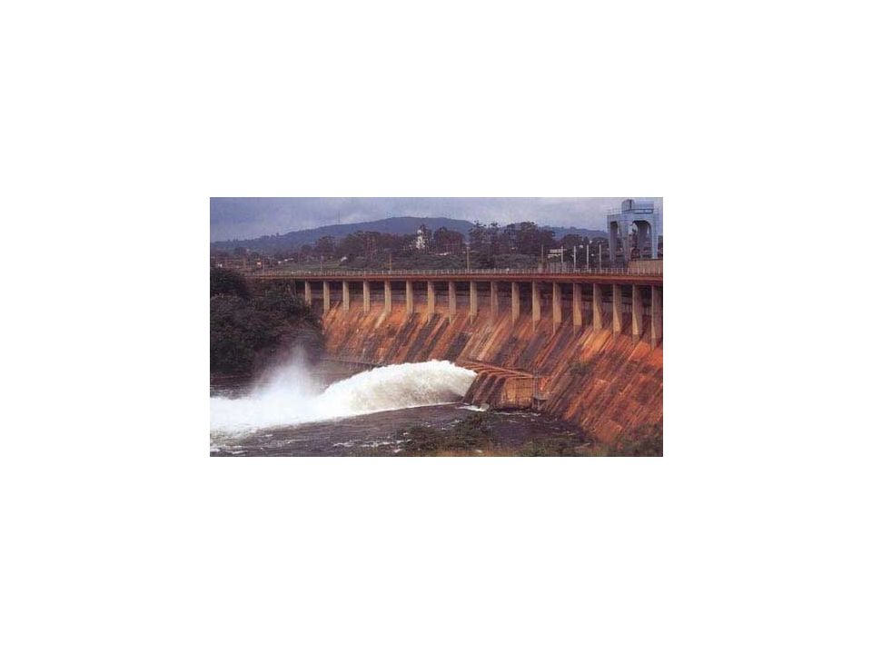
13
Standard way that map show information Symbols Color Lines Boundaries Contours

14
Types of Thematic Maps Population Economic Activity Resource Language Ethnicity Climate Precipitation Vegetation Physical Political

15
Projections Mercator –ship navigation Polar – airline navigation Robinson-data representation

16
Aspects of the Earth that can be distorted Area Shape Distance Direction

17
Climate is defined by certain characteristics Temperature Precipitation Seasons( hot/cold, wet/dry)
")
18
Climate regions have distinctive vegetation

19
Climate Patterns result from the interplay of common elements Influence of latitude Influence of winds Influence of elevation Proximity to water

20
World Climate regions Low latitudes: tropical wet &dry, arid, semiarid, and highland Middle Latitudes: Semiarid, arid, Mediterranean, humid continental, marine west coast, humid subtropical. High latitudes: sub arctic, tundra, and ice cap.

21
Vegetation Regions Tropical rain forest Savanna Desert Steppe Middle Latitude Forest Taiga Tundra

22
Certain weather phenomena Monsoons-south and southeast Asia Typhoons-pacific ocean Hurricanes- Atlantic Ocean Tornadoes –United States

23
Climates and weather affect how people live in different regions

24
Physical and ecological processes shape the Earth’s surface Earthquakes Floods Volcanoes Erosion

25
Humans both are affected and affect their environment Water diversion/ management Changing landscapes Environmental changes

26
Water Diversions and Management: can help the earth and can hurt the earth. Help Irrigation for farming Reservoirs for energy Canals makes trading easier because travel is easier. Harmful Aral Sea Colorado River Aswan High Dam

27
Aral Sea

29
Colorado River

31
Aswan High Dam

34
Canals

35
Reservoirs

36
Irrigation

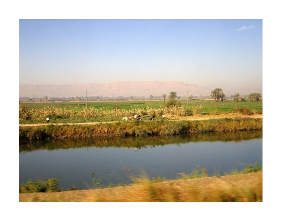
37
Landscape Alteration

39
Agricultural Terracing

40
Polders

41
Deforestation

42
Desertification

43
Acid Rain

44
Pollution (oil spill)
")
45
Changing Landscape: anytime the earth surface is changed by humans. Helpful Agricultural terracing Polders Harmful Deforestation Desertification

46
Environmental Change Acid Rain Pollution

47
Environmental Impact on humans Settlement patterns Housing Materials Agricultural activity Types of recreation Transportation pattern

48
Technology has expanded people capability to modify and adapt to their physical environment.

49
Adaptations to the environment Agriculture (fertilizers, mechanization) Energy Usage (fossil fuels, nuclear) Transportation (road buildings, railways) Automobiles (parking lots, suburbs) Airplanes (airports, noise)
 Energy Usage (fossil fuels, nuclear) Transportation (road buildings, railways) Automobiles (parking lots, suburbs) Airplanes (airports, noise)")
50
Regions are areas of the Earth’s surface which share similar unifying characteristics. They are used to simplify the world for study and understanding.

51
Region may be defined by physical or cultural characteristics.

52
Physical Regions

53
Sahara

54
Taiga

55
Rain Forest

56
Great Plains

57
Low Countries

58
Regional Labels may reflect changes in people’s perceptions Middle East Sun Belt Rust Belt

59
Regional Landscapes reflect cultural characteristics of their inhabitants Architectural structures Dwellings

60
Regional labels Middle East Sun Belt Rust Belt

61
Regional Landscapes Architectural structures Religious structures Dwellings Statues and Monuments

62
Religious Structures Mosques (Islam) Church (Christianity) Synagogues (Jewish) Temples ( Hindu) Pagodas ( Buddhist)
 Church (Christianity) Synagogues (Jewish) Temples ( Hindu) Pagodas ( Buddhist)")
63
Buddhist Temple

64
Church

65
Pagodas

68
Hindu Temple

69
Mosques

70
Statues and Monuments

71
Taj Mahal : India

72
Kaaba: Mecca, Saudi Arabia

73
Western Wall: Jerusalem

74
Dome of the Rock: Jerusalem

75
Church of the Holy Sepulcher

76
Pyramids: Egypt

77
Kremlin: Russia

78
Eiffel Tower

79
Virginia State Capital: Richmond

80
Washington Monument: Washington D.C.

81
White House

82
Lincoln Memorial

83
Statue of Liberty

84
The development of a region is influenced by many factors, including physical, economic, and cultural characteristics.

85
Different criteria may be used to determine a country’s relative importance GDP Land Size Population Size Resource

86
Elements of the physical environment such as major bodies of water and mountains, influence the economic and cultural characteristics of regions.

87
Water Rio Grande –boundary Ob River-flows northward into Arctic Ocean Zambezi River-water power Ganges and Brahmaputra-flood hazard

88
Mountains Rocky Mountains-Create rain shadows on leeward slopes Himalayas-block moisture to create steppes and deserts in Central Asia

90
Lincoln Memorial

Similar presentations


>")


