Download presentation
Presentation is loading. Please wait.

1
Judd Muskat – OSPR Joanne Phillips - CalOES

2
Used for Situation Display in ICP Used For Data Dissemination To Broad Response Community via Common Web Browser Used for Informed Decision Making Used for Operations Planning Provides The Capability For Desktop Analysis And Cartographic Products

3
Available to Entire Response Community Multiple Levels of Data Access Responder – All Access General Public – Limited Access (Situation Display for Public Consumption as Directed by the UC) Ability to Turn Individual layers On/Off Ability to Create and Download Custom Maps Ability to Download GIS Files
 Ability to Turn Individual layers On/Off Ability to Create and Download Custom Maps Ability to Download GIS Files")
4
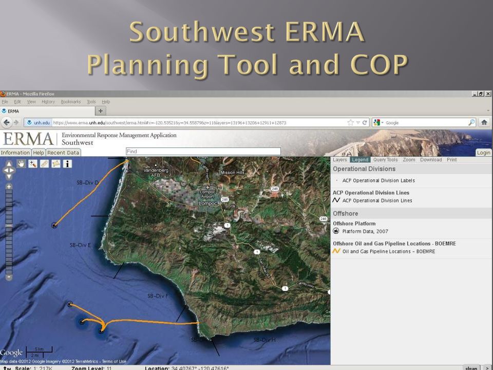
Developed by NOAA (OR&R) and UNH Specifically Designed as a Oil Spill Response Tool California’s COP of Choice (Southwest ERMA) Valuable Planning Tool OSPR Populated W/ACP Data Layers And Provided Input On Improving Application For Spill Responders Provides Interactive Map Display Capabilities to Responders on local Desktop, Tablet… Web Based, with No Proprietary Software Needed for Use Several Credential Based Levels of Access
 and UNH Specifically Designed as a Oil Spill Response Tool California’s COP of Choice (Southwest ERMA) Valuable Planning Tool OSPR Populated W/ACP Data Layers And Provided Input On Improving Application For Spill Responders Provides Interactive Map Display Capabilities to Responders on local Desktop, Tablet… Web Based, with No Proprietary Software Needed for Use Several Credential Based Levels of Access")
10
One – In the ICP. Authorized Early in the Response by the UC Many – Offsite, Individual “In-House” Data Viewers Using Data Sourced from SITU A Signed Data Sharing Agreement Will Assure All Parties Have Same Data Sets. DO NOT WANT COMPETING COPs in the ICP LEADS TO CONFUSION

12
Provides factsheets, maps and information about large oil spill response events

13
For smaller events and oil spill news and discussions

14
For late breaking oil spill news

15
Pastor Guevara Cal OES – Southern Region

16
A web enabled Emergency response system powered by WebEOC to document incidents. Is like a file cabinet and each incident is a file. It doesn’t change what anyone does (processes or procedures), it changes how you document it. Organized by ICS with branches or EFs/ESFs, compliant with SEMS and NIMS. All items may be printed or saved as a.pdf file. Many counties have WebEOC so the State calls their WebEOC system CalEOC.
, it changes how you document it. Organized by ICS with branches or EFs/ESFs, compliant with SEMS and NIMS. All items may be printed or saved as a.pdf file. Many counties have WebEOC so the State calls their WebEOC system CalEOC..")
17
CalEOC is accessible to all Operational Areas, Cal OES Regions and the State Operations Center, State agencies and other partners with a role in emergency management. (Potential future connectivity with FEMA.) To connect to CalEOC, you need internet capability, a browser and a device (computer, laptop, tablet or Smart phone); Flash is needed to run the Mapper application. Maintenance will be accomplished with a SEMS sub- committee.
 To connect to CalEOC, you need internet capability, a browser and a device (computer, laptop, tablet or Smart phone); Flash is needed to run the Mapper application. Maintenance will be accomplished with a SEMS sub- committee..")
18
Your Control Panel shows what you can do (partial Plans SREOC Tech Spec here) Significant Events Situation Report Mission/Resource Requests Action & Advance Plans FEMA/ICS Forms And others Enter information to Activity Log (ICS-214) or to a Board.
 Significant Events Situation Report Mission/Resource Requests Action & Advance Plans FEMA/ICS Forms And others Enter information to Activity Log (ICS-214) or to a Board.")
22
There are other Boards in the system for inputting and tracking items, some of these are: Evacuations Shelters (People and Animals) Road Closures State of the State Debris Removal Status Hospital State Points of Distribution (PODs) School Status Proclamations
 Road Closures State of the State Debris Removal Status Hospital State Points of Distribution (PODs) School Status Proclamations")
25
Pastor Guevara Cal OES – Southern Region Office: 562-795-2955 Cell: 562-338-8440 Email: pastor.guevara@caloes.ca.gov Judd Muskat CDFW - OSPR Office: 916-324-3411 Email: judd.muskat@wildlife.ca.gov

Similar presentations


 with disaster related duties shall be WebEOC.>")
>")


 for Public Safety>")


