Download presentation
Presentation is loading. Please wait.

1
Local and Sky Coordinates
Note ! Slides 1 – 5 are for review only.

2
Review Latitude: measures position north or south of equator
Longitude: measures position east or west of prime meridian Use this for a brief review of latitude and longitude; it’s also useful to bring in a real globe to class for this purpose. The photo at right is the entrance to the Old Royal Greenwich Observatory (near London); the line emerging from the door marks the Prime Meridian.
; the line emerging from the door marks the Prime Meridian.")
3
Review Sky Coordinates
The celestial sphere is an imaginary object Useful as a model for positional astronomy Its landmarks are projections of those on the Earth Hint: it helps to sketch and label this

4
Celestial poles- where the Earth’s axis would intersect the CS
Polaris < 1° away from north celestial pole, called the North Star or the Pole Star.

5
Celestial equator divides the sky into northern and southern hemispheres
Declination – similar to latitude, measures degrees above or below the celestial equator

6
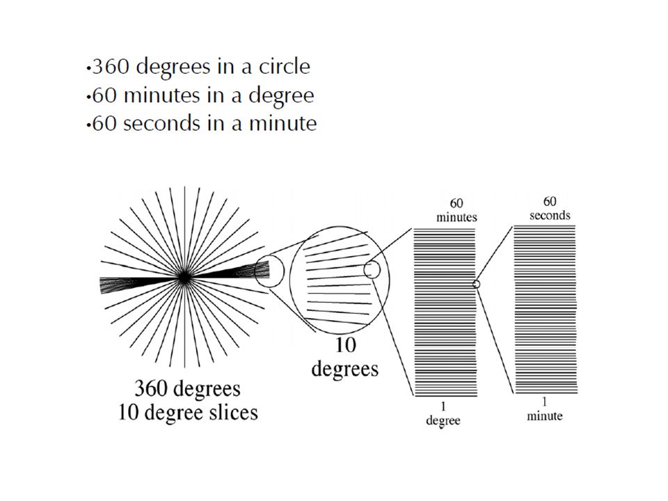
Declination Measured in standard degrees, minutes, and seconds
Written with these symbols Degrees ° Minutes ′ Seconds ″ Example: 42 °13 ′ 22 ″

8
Zero is aligned with the celestial equator
•Positive values are North •Negative values are South •90 degrees N is the North Celestial Pole (near Polaris)
")
9
Right Ascension (RA) Similar to longitude
Measures East and West Position zero location at the Vernal Equinox

10
This is where the ecliptic crosses the celestial equator, heading north
Position of the sun on 21 March First day of Spring

11
Since the sky takes 24 hours to rotate, RA is measured in hours.
There are 24 hours in a day Therefore 24 h of RA in a circle RA hours are subdivided into minutes and seconds Symbols are different than for degrees Example: 22 h 34 min 16 sec

12
The Local Sky Zenith: The point directly overhead
Horizon: All points 90° away from zenith Meridian: Line passing through zenith and connecting N and S points on horizon Now we move from the celestial sphere to the local sky. The local sky looks like a dome because we see only half the celestial sphere. If we want to locate an object: It’s useful to have some reference points. Students will probably already understand the horizon and the cardinal directions, but explain the zenith and the meridian; a simple way to define the meridian is as an imaginary half-circle stretching from the horizon due south, through the zenith, to the horizon due north. Now we can locate any object by specifying its altitude above the horizon and direction along the horizon. A good way to reinforce this idea is to pick an object located in your class room, tell students which way is north, and have them estimate its altitude and direction.

13
The Local Sky Altitude and Azimuth are latitude and longitude in the sky Altitude: how many degrees above the horizon something is. Azimuth: how many degrees along the horizon it is and corresponds to a compass direction from north Now we move from the celestial sphere to the local sky. The local sky looks like a dome because we see only half the celestial sphere. If we want to locate an object: It’s useful to have some reference points. Students will probably already understand the horizon and the cardinal directions, but explain the zenith and the meridian; a simple way to define the meridian is as an imaginary half-circle stretching from the horizon due south, through the zenith, to the horizon due north. Now we can locate any object by specifying its altitude above the horizon and direction along the horizon. A good way to reinforce this idea is to pick an object located in your class room, tell students which way is north, and have them estimate its altitude and direction.

Similar presentations


>")


