Download presentation
Presentation is loading. Please wait.

1
A abbreviated history of aerial photography and digital remote sensing
CWU, Geog With special thanks to and

2
The earliest stuff…. Mid 1800s. Photos from balloons.
First known – a shot of Boston taken in

3
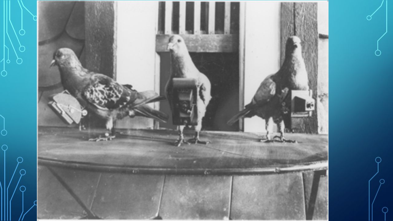
Soon thereafter Kites Pigeons! Rockets.
1906 huge panoramas of San Fran after the fires. 17 kites to lift camera 2000 feet. Pigeons! 1903 – first camera designed for homing pigeons. Homing pigeons, cameras set on timers. Bavarian Pigeon Corps! No kidding. Rockets. First successful pic taken from a rocket was by Alfred Nobel. Yeah, THE Nobel. But, by 1912 or so, airplanes were taking off. Literally.

4
SF, 1906 http://professionalaerialphotographers. com/content. aspx

6
http://professionalaerialphotographers. com/content. aspx

7
Ahhh.. Airplanes! First pics in about But things didn’t really start to take off until WWI

8
Many issues at first! Propeller blast;
Lens fogged by oil thrown by the engine; Difficulty in aiming and framing; Struts and wires block vision; Observers distracted by multiple duties, including observation, navigation, and defense against enemy pursuit aircraft Vertical photography difficult; Changing plates in flight difficult; No supplemental oxygen Hard to get results to field quickly Solutions?

9
However, During the war, aerial photography proved itself as the best way to do reconnaissance. Started to hard-mount cameras, etc. Nonetheless, traditionalists in the military kept this technology from becoming mainstream. Balloons still used, too. A much more stable platform, though far less versatile and more vulnerable. (note, we still use weather balloons!)
")
10
Rapid increase in the use of aerial photos (ie. USGS) and technological improvements included better cameras, planes, and tools/technologies for interpreting said photos.
 and technological improvements included better cameras, planes, and tools/technologies for interpreting said photos.")
11
WWII This is when aerial photography really took off. Military value both recognized and embraced. Included imaging in the thermal band 1930s, first black and white infrared films 1960s, false color films.

12
Post WWII US federal government take a bajillion pics over the years. Basically, 1955 – present. All are archived. For more info Or to download:

13
Cold war! Cuban Missile Crisis
The U2 – dedicated reconnaissance plane. 1955 70,000 ft 1960 shot down over Soviet Union. Ushered in satellite remote sensing. Still in service.

14
Aerial photography continues
But largely digital these days. State of the art are military drones, which send back amazing amounts of information and can stay in the air for a very long time.

15
Now, finally, into Satellite remote sensing
TIROS 1, Weather satellite. Television transmission of data. Real-time if a ground station within range. Over the years, many successive generations build, leading to what you see on weather.com! (GOES satellites. .6 miles visible, 2.5 mile res IR).
.")
16
Contrast with

17
Corona First spy satellite. Basically, a regular ole film camera in space. Had to eject film canisters and pick them up. The first photo taken from a satellite The first recovery of an object from space and the first in mid-air. The first mapping of Earth from space. The first use of multiple re-entry vehicles. The first space program to fly 100 missions.

19
Earth observing satellites
Landsat series. Landsat 1, Wheat and SALT Objective was to be able to track what happens on the ground – both what is where and change over time. Landsat satellites still up!

21
Now, a break from history
And on to resolution and the electromagnetic spectrum.

Similar presentations


>")