Download presentation
Presentation is loading. Please wait.

1
3rd grade Maps and Geography Unit
Jeopardy 3rd grade Maps and Geography Unit

2
Maps & Geography Jeopardy
Vocabulary & Map Parts Alabama Oceans United States Continents Q $100 Q $100 Q $100 Q $100 Q $100 Q $200 Q $200 Q $200 Q $200 Q $200 Q $300 Q $300 Q $300 Q $300 Q $300 Q $400 Q $400 Q $400 Q $400 Q $400 Q $500 Q $500 Q $500 Q $500 Q $500 Maps & Geography Jeopardy Final Jeopardy

3
$100 Question Vocabulary & Map Parts
Symbols: look like people. are not on a map. stand for something else on a map. stand for sounds.

4
$100 Answer Vocabulary & Map Parts
Symbols stand for something else on a map (c). ??
.")
5
$200 Question Vocabulary & Map Parts
The equator is: a place at the north pole. an imaginary line running around the middle of the Earth on a map or a globe. not on a map. not on a globe.

6
$200 Answer Vocabulary & Map Parts
The equator is an imaginary line running around the middle of the Earth on a map or a globe (b). ??
.")
7
$300 Question Vocabulary & Map Parts
What are the three (3) parts of a map?
 parts of a map")
8
$300 Answer Vocabulary & Map Parts
Title, compass rose (or directional indicator), and legend (or map key) ??
, and legend (or map key)")
9
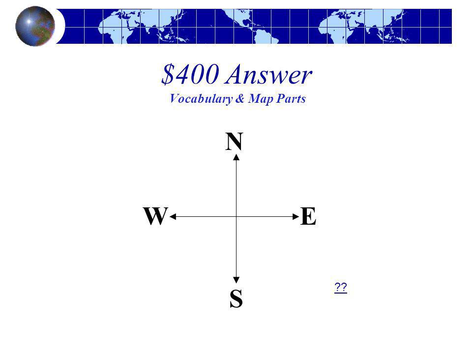
$400 Question Vocabulary & Map Parts
Identify the directions on this compass rose.

10
$400 Answer Vocabulary & Map Parts
??
11
$500 Question Vocabulary & Map Parts
How is a map different from a globe?

12
$500 Answer Vocabulary & Map Parts
A map is a flat picture of the Earth, and a globe is a model of the Earth. ??

13
$100 Question Alabama Alabama’s shape is most like a: triangle.
square. circle. rectangle.

14
Alabama’s shape is most like a rectangle.
$100 Answer Alabama Alabama’s shape is most like a rectangle. ??

15
What is the name of the longest free flowing river in Alabama?
$200 Question Alabama What is the name of the longest free flowing river in Alabama?

16
$200 Answer Alabama The Cahaba River ??

17
Which dot on this map of Alabama is Birmingham (red or blue)?
$300 Question Virginia Which dot on this map of Alabama is Birmingham (red or blue)?
")
18
Birmingham is the red dot on this map.
$300 Answer Alabama Birmingham is the red dot on this map. ??

19
What is the blue dot on this map of Alabama?
$400 Question Alabama What is the blue dot on this map of Alabama?

20
The blue dot on this map is Montgomery.
$400 Answer Alabama The blue dot on this map is Montgomery. ??

21
$500 Question Alabama What mountain range runs from Canada to Alabama?

22
Appalachian Mountains
$500 Answer Alabama Appalachian Mountains ??

23
$100 Question Oceans Which ocean is shown in blue on this map?

24
$100 Answer Oceans Atlantic Ocean ??

25
$200 Question Oceans Which ocean is shown in blue on this map?

26
$200 Answer Oceans Pacific Ocean ??

27
$300 Question Oceans Which ocean is shown in blue on this map?

28
$300 Answer Oceans Arctic Ocean ??

29
$400 Question Oceans Which ocean is shown in blue on this map?

30
$400 Answer Oceans Indian Ocean ??

31
What 3 oceans touch North America?
$500 Question Oceans What 3 oceans touch North America?

32
$500 Answer Oceans Atlantic, Pacific, and Arctic Oceans ??

33
$100 Question United States
What letter on this map is the Mississippi River?

34
$100 Answer United States ?? C is the Mississippi River

35
$200 Question United States
What letter shows the mountains closest to Virginia?

36
$200 Answer United States E – Appalachian Mountains ??

37
$300 Question United States
What river divides Texas from Mexico? Rio Grande River Mississippi River James River

38
The Rio Grande River divides Texas
$300 Answer United States The Rio Grande River divides Texas from Mexico (a). ??
.")
39
$400 Question United States
What is the name of the region labeled ‘D’?

40
$400 Answer United States ?? D - Great Lakes Region

41
$500 Question United States
What mountain range is on the western side of the United States? Massanutten Appalachian Mountains Rocky Mountains

42
The Rocky Mountains are on the western side of the United States (c).
$500 Answer United States The Rocky Mountains are on the western side of the United States (c). ??
.")
43
$100 Question Continents What continent is shown in red on this map?

44
$100 Answer Continents Antarctica ??

45
What continent is shown in purple on this map?
$200 Question Continents What continent is shown in purple on this map?

46
$200 Answer Continents South America ??

47
What continent is shown in orange on this map?
$300 Question Continents What continent is shown in orange on this map?

48
$300 Answer Continents Australia ??

49
What continent is shown in blue on this map?
$400 Question Continents What continent is shown in blue on this map?

50
$400 Answer Continents ?? Africa

51
Which 2 continents are mostly connected?
$500 Question Continents Which 2 continents are mostly connected?

52
$500 Answer Continents ?? Europe and Asia

53
Final Jeopardy Why is the Pacific Ocean shown in two different
places on a map of the world?

54
The Pacific Ocean is shown in two places on a map of the world because
Final Jeopardy The Pacific Ocean is shown in two places on a map of the world because the world is round, but a map is flat. In order to make it flat, they had to divide the ocean in half.

Similar presentations


>")

