Download presentation
Presentation is loading. Please wait.

1
DAVID HAMMONDS ENVIRONMENTAL MANAGER FLORIDA DEPARTMENT OF HEALTH
Soil Profile Documentation August 19, 2011 DAVID HAMMONDS ENVIRONMENTAL MANAGER FLORIDA DEPARTMENT OF HEALTH Our bureau contact numbers are provided in case you need to ask questions about this online training.

2
Requirements For Completing Soil Profiles

3
Anyone performing soil profiles must follow the same procedures
CHD’s have additional duties when the work is performed by non-departmental personnel

4
CHD Review Duties Must check all applications for correctness/completeness. Where incorrect or incomplete, correction is required. Non-departmental evaluators must, at a minimum, comply with 64E-6 standards. However they can make additional requirements (e.g. more drainfield, a specific drainfield type, etc.).
.")
5
Each soil profile: Must be performed correctly
Must use USDA NRCS methodology Must be documented correctly Stands on its own (see next slide) Establishes facts (something determined by evidence) i.e. soil colors, textures, SHWT indicators, etc.
 Establishes facts (something determined by evidence) i.e. soil colors, textures, SHWT indicators, etc.")
6
Stands on it’s own???? This means that each profile must be able to allow the system to be installed according to regulations when using the profile by itself. Why? The system is being installed where the profiles are performed. Most restrictive conditions must be used.

7
Point of Refusal Point of refusal (or termination, etc.) indicates that the soil profile could not be advanced to the required 72” depth. Once 72” is reached, point of refusal is not normally used (due to 72” min. depth). Point of refusal must be clearly documented as to reason for “refusal”.
. Point of refusal must be clearly documented as to reason for refusal .")
8
Examples of Refusal Hole collapses due to excessive water; ironstone; excessive roots; excessive debris; etc. “Didn’t want to dig” is not a reason. In all cases, the evaluator must not be able to proceed further. The reason must be given and recorded on the profile information or remarks section.

9
Soil is spatially variable
Once a soil profile is terminated above 72”, it cannot be assumed what lies below the depth of termination (spodic layer, limestone, clay?). The termination point of the profile will influence the bottom of the drainfield due to the effective soil depth requirements. This could raise the system more than the separation to SHWT requirement.
. The termination point of the profile will influence the bottom of the drainfield due to the effective soil depth requirements. This could raise the system more than the separation to SHWT requirement.")
10
Example One soil profile has FS down to 72”, the other shows FS and the hole caving at 46” due to water intrusion (or bedrock, boulders, buried tree stump, whatever). The point is that the profile ends at 46”. The profile that goes down to 72” cannot be used to justify the effective soil depth in the other profile. This makes the 46” depth the more restrictive profile and therefore must be used to install the system.
. The point is that the profile ends at 46 . The profile that goes down to 72 cannot be used to justify the effective soil depth in the other profile. This makes the 46 depth the more restrictive profile and therefore must be used to install the system.")
11
Effects on System Requirements
Presume the more restrictive SHWT between the profiles was determined to be at 42”. The effective soil depth would have to be based on 46”, not 72”. This would mean that the elevation of the bottom of the drainfield would be higher based on the effective soil depth requirement rather than the SHWT requirement (14” difference).
.")
12
Continuing with ramifications…
Adds height to the system, will add a fill requirement, in this case goes from standard subsurface system to 14” filled system. Affects placement of system, system geometry, ability of system to be permitted for use. If it were to go from fill to mound system the drainfield size could increase (depending on fill material), which would increase the unobstructed area, exacerbating above issues.
, which would increase the unobstructed area, exacerbating above issues.")
13
When CHD’S perform confirmatory soil profiles to check non-CHD personnel work (or when checking any type of fill material) the same procedures must be followed. When the results are different or unsatisfactory, the profiles must be documented for enforcement measures.

14
The Site Evaluation Form

15
The Site Evaluation Form -Front side

16
The Site Evaluation Form- Back side

17
The part of the site evaluation form discussed in this presentation

18
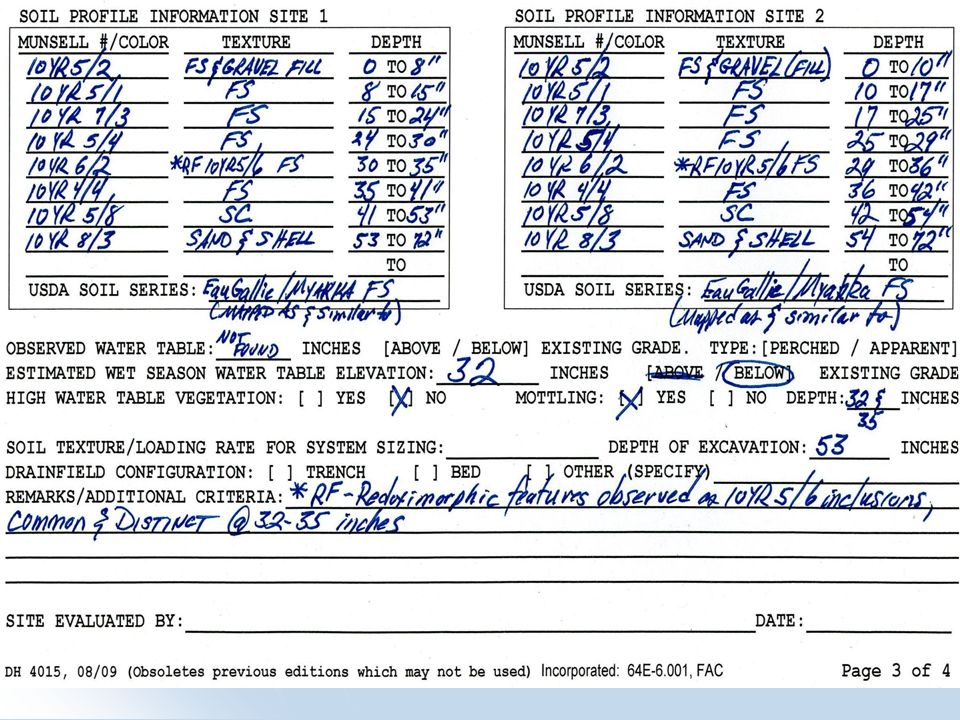
In the column with the heading "Munsell #/Color," Munsell notation must be used. This includes the hue, value and chroma in the specified format, which is: HUE VALUE/CHROMA (10YR 7/4).
.")
19
For example, the color 10YR 7/4
For example, the color 10YR 7/4. It is not necessary to add the name of the color, however, if used, the correct color name must be written out. For example 10YR 7/4 has a corresponding color of "very pale brown," NOT "tan.” Note that the color “tan” DOES NOT exist in the Munsell soil color scheme.

20
DUE TO RULE RESTRICTION, USDA NRCS TEXTURES AND METHODOLOGIES ARE THE ONLY ONES THAT ARE ACCEPTABLE FOR DOH USE

21
The column with the heading "Texture," must be completed using the correct USDA NRCS texture for each horizon. The use of non-standard abbreviations cannot be accepted. The use of the term "fill" in this column should be used when necessary, along with the corresponding texture(s) of the fill material.
 of the fill material..")
22
Proper texture abbreviation

23
Note that ONLY the USDA NRCS particle sizes are used
Note that ONLY the USDA NRCS particle sizes are used. Textures given in any other particle size or texture classification system are not acceptable. Some examples: Mucky Peat would be abbreviated as MK Peat. Note that the term "organic" is not listed. Organic soils are listed as muck, mucky peat or peat.

24
Spodic (Bh) horizons should be noted as such
Spodic (Bh) horizons should be noted as such. While a spodic layer contains organic matter that coats mineral soil particles , it is not an organic soil layer nor mucky mineral due to the small amount (<5%) of organic matter (carbon).
 horizons should be noted as such. While a spodic layer contains organic matter that coats mineral soil particles , it is not an organic soil layer nor mucky mineral due to the small amount (<5%) of organic matter (carbon).")
25
For example 10YR 2/1 FS Spodic 16-23 inches
This entry indicates a horizon of black fine sand that exists as a spodic layer from 16 to 23 inches. This is NOT an organic layer. Mucky mineral must have at least 5% organics and muck must have at least 12% organics. A spodic contains <5% organic matter (carbon), generally 1-3%.
, generally 1-3%.")
26
A word about spodic layers
By definition, spodic layers are a sandy material. They can be any texture sand. As long as it has the word “sand” and is a REAL texture, it can be used. Proper Examples: LFS, S, FS, VFS UNACCEPTABLE Examples: Muck, SiL, Silty fine sand, organics

27
Particle Sizes Larger Than The Fine Earth Fraction
A.K.A. “Bigger Than Soil” Particles

28
NON-SOIL PARTICLES (Coarse Fragments)
Particles larger than 2 mm are not soil particles (i.e. the fine-earth fraction), they are Coarse Fragments. They do figure in to the overall texture of a soil by modifying the soil texture.
, they are Coarse Fragments. They do figure in to the overall texture of a soil by modifying the soil texture.")
29
When the particle size exceeds 2mm, it moves out of the very coarse sand texture and is no longer a soil particle. These items can include shells, rocks, or other non-soil (non-fine earth) items that are >2mm. The modifier "GR" is used when the fragment content by volume is ≥15% to <35%. Gravels range in size up to 75mm (3 inches).
 items that are >2mm. The modifier GR is used when the fragment content by volume is ≥15% to <35%. Gravels range in size up to 75mm (3 inches)..")
30
For example, If there are 20% shell fragments that are >2mm in size and the soil texture is sand, the proper texture for that soil would be gravelly sand, or GR S. This example is an unsuitable soil type, as it is severely limited and could not be used for system installation. Use the "Charts for Estimating Proportions of Mottles and Coarse Fragments" found in the Munsell book to determine the percentage of fragments.

31
Soil Texture Determination
Must remove the gravels from consideration in order to get actual soil texture (if ≥ 15% by volume of the soil horizon). This is done by running sample through a nest of sieves. After large particles removed, the remaining sample is the entire soil sample and will be used to determine the texture of the soil.
. This is done by running sample through a nest of sieves. After large particles removed, the remaining sample is the entire soil sample and will be used to determine the texture of the soil.")
32
Soil Texture Determination
Once soil texture is determined, will add the proper adjective (e.g. gravelly, very gravelly, etc.) to soil texture to properly name the soil. Example: Gravelly Loamy Fine Sand indicates that ≥15% and <35% gravels occupied the volume of the soil horizon that was a Loamy Fine Sand Texture.
 to soil texture to properly name the soil. Example: Gravelly Loamy Fine Sand indicates that ≥15% and <35% gravels occupied the volume of the soil horizon that was a Loamy Fine Sand Texture.")
33
Notes on Proper Use of Texture
There is no acceptable texture such as “shelly sand” as the word “shell” has no actual meaning for size. Shell is a type of particle, not the size of a particle. Use the proper adjective to describe the large coarse fragments of the horizons.

34
REDOXIMORPHIC (Redox) FEATURES
 FEATURES")
35
Redox Feature Identification
The site evaluation form asks for indications of "mottles." What is required here are redoximorphic features only, that is, a mottle whose color change was caused by the presence of water. Use for all redox features.

36
Mottling=Redox feature

37
Note that not all mottles are associated with the seasonal high water table (SHWT). Do not put the depth of non-redox features in the “mottling” depth location. Redoximorphic features must be described in quantity, contrast and color. Where present, must be described in all profiles.

38
The department accepts the following abbreviations for quantity and visual contrast of redox features, which can be abbreviated as RF. Quantity of feature: Common - CMN; Many - write out Visual Contrast of feature: Distinct - DST; Prominent - PRM. So, what is the visual contrast between faint, distinct and prominent?

39
Contrast of Colors Contrast refers to the degree of visual distinction between associated colors. Faint – contrasts that are evident only on close examination Distinct -- contrasts that are readily seen but are only moderately expressed Prominent -- contrasts that are strongly expressed

40
What we use to define the soil color contrast is a USDA NRCS document (DOH use since 2004)
")
41
USDA NRCS Soil Survey Technical Note No. 2 May 2002
Soil Color Contrast Definitions

42
The presence of the redoximorphic features (if existing) must be indicated in the soil profile, or must be listed in the remarks section of the profile. Use the following examples.

43
10YR 3/2 FS 0-5" 10YR 5/3 FS " 10YR 7/4 FS " 7.5YR 6/8 CMN/PRM RF 16-20" 10YR 8/1 FS “ Alternately, the row with the redoximorphic information could be omitted in the soil profile information if the information was placed in the remarks section.

44
“Mottling” Yes or No On the site evaluation page, three lines below the soil profile information, it asks if mottling is present and the depth in inches. Mottling is synonymous with the term “Redoximorphic Feature”.

45
The RF that is used to determine the SHWT is what goes in the blank.
Additional redox features, while documented as colors and depths in the profile, are not entered into the “mottle” area. Can enter additional information in Remarks area.

46
In the above example, the mottling would be marked as "yes" and the depth in inches would be 16, which is where the common prominent redox feature started. This must correspond with the information in the profile and remarks section.

47
In the column heading "Depth", the beginning and ending depth of the soil horizon (layer) is recorded. This is a soil profile description, not a soil log. Soil logs are NOT acceptable. Depths are given for the boundaries of soil horizons, not in evenly spaced increments (such as 0-6", 6-12", etc.). While soil profiles may on occasion match, one should expect differences in the colors and depths of each horizon in individual profiles.
. While soil profiles may on occasion match, one should expect differences in the colors and depths of each horizon in individual profiles..")
48
Note that the redoximorphic feature line in the previous example shows the feature existed from 16-20”. This could also be listed as 16-16” if that is the depth where the feature occurs. (Note there is no thickness requirement for the redox features in this particular example.) The Environmental Health Database requires horizons to have a beginning and ending point, but it can be the same point (depth) So…….
 The Environmental Health Database requires horizons to have a beginning and ending point, but it can be the same point (depth) So…….")
49
If an evaluator only lists one depth (e. g
If an evaluator only lists one depth (e.g. 16”) where the redox feature is located, this is not necessarily an error. Use the depth given as the beginning and ending depth for the area containing the redox feature. If the redox feature is listed in the remarks section, the CHD will normally enter the data as a remark.
 where the redox feature is located, this is not necessarily an error. Use the depth given as the beginning and ending depth for the area containing the redox feature. If the redox feature is listed in the remarks section, the CHD will normally enter the data as a remark.")
50
The soil profile must contain all information to document and validate the corresponding conclusions drawn from the profiles, including the estimated seasonal high water table determination, soil textures and effective soil depth. Lack of or inconsistency between any required information is scientific basis to question the evaluation.

51
For example, in a profile that indicates no redoximorphic features either listed in the soil profile or remarks section, the mottling question has "no" and the evaluator indicates an estimated seasonal high water table at 10 inches. This cannot be accepted by the CHD as there is no scientific basis for the estimation of the seasonal high water table.

52
Lack of Redox Features What to do

53
Redoximorphic features need certain conditions in which to form.
In certain cases, these conditions will not be present and redox features will not be found. This can happen in naturally occurring soils where there is very little organic matter or iron content, such as in beach areas, or in the situation where fill material has been moved on top of an otherwise natural soil.

54
The fill material can be anywhere from a few inches to several feet thick, and have been in place for a few days to decades, and can vary greatly in texture. These soils can be very problematic. The SHWT can still be higher in the profile, even within the fill material.

55
Seasonal High Water Table Indicators (Contemporary vs. Relict)
")
56
Contemporary vs. Relict
CONTEMPORARY FEATURES - Soil morphological features that reflect current hydrologic conditions of saturation and anaerobiosis. These ARE used to determine SHWT. Diffuse boundaries. RELICT FEATURES - Soil morphological features that reflect past hydrologic conditions of saturation and anaerobiosis. These ARE NOT used to determine SHWT. Sharper boundaries.

57
RELICT FEATURES In our case, relict features would also include mottles that have been transported in fill material and cannot be used to determine SHWT.

58
Absence of Redox features
In the case where absolutely no redox features are found in the soil, for example in some beach-area soils, the experience of the site evaluator will come into play. For example, at a beach location, if a soil profile showed a 10YR 8/1 sand from 0-72 inches, no observed redoximorphic features, but an observed water table existed at 54 inches, and it had not rained in several weeks, there would be cause to consider the actual water table in light of the lack of redoximorphic features.

59
Absence of Redox features
The amount of consideration would be based on the individual evaluator's experience and judgment. By way of this example, it could mean that a county health department (CHD) employee that has ample experience in the area in question has knowledge that water tables exist for several days or weeks at a time (as in the above example) at 48", even though no redox features are present.
 employee that has ample experience in the area in question has knowledge that water tables exist for several days or weeks at a time (as in the above example) at 48 , even though no redox features are present.")
60
Absence of Redox features
Another evaluator (private or not) may not have the same experience and would not reach the same conclusion. In this example, the CHD employee (or non-department employee) would use their experience and judgment to determine the estimated seasonal high water table from all different sources required by rule, and this information would have to be documented during the site evaluation, in the soil profiles and in the remarks section. As in all site evaluations, the SHWT determination must be validated using all available information.
 may not have the same experience and would not reach the same conclusion. In this example, the CHD employee (or non-department employee) would use their experience and judgment to determine the estimated seasonal high water table from all different sources required by rule, and this information would have to be documented during the site evaluation, in the soil profiles and in the remarks section. As in all site evaluations, the SHWT determination must be validated using all available information.")
61
Absence(?) of Redox features
From a historical perspective, it has been our experience that it is not uncommon for certain indicators to be missed, or misused, especially when the methodology in use is other than that employed by the USDA NRCS, which is required by regulation. This has resulted in improper seasonal high water table estimations.

62
VALIDATION OF SHWT We know that there are cases where there will not be indicators. When this occurs, all sources required by rule would be used as well as the professional judgment of the evaluator to state why the SHWT was determined to be at a specific level.

63
VALIDATION OF SHWT There is not a specific statement that has been used to cover all scenarios, but we are also trying to guard against the evaluator that is not using contemporary indicators (when present) and just stating a depth and "the call was based on my professional experience".
 and just stating a depth and the call was based on my professional experience .")
64
Consider the following information
10YR 3/1; 5/4; 6/3 FS Fill 0-21” 10YR 4/1 FS ” 10YR 4/1; 5/2 FS ” 10YR 2/ Spodic Material 35-50” REFUSAL REFUSAL 50” REMARKS: Observed water table at 34”, refusal due to hole caving in. No rain in 5 weeks. SHWT 27”.

65
Example of WRONG reasoning for previous slide:
No clear indicators of seasonal high water could be observed. Due to filled nature of lot, 21” represents “natural grade”. Set SHWT at natural grade; this is conservative call for SHWT.

66
Now, a Proper Statement Determination of the SHWT was based on a combination of the following: While no specific redox features were observed, the several inches of generally grayer (low chroma) soils that exist in the upper part of the natural soils is normally indicative of SHWT being closer to the ground surface when viewed in relation to the spodic horizon, and considering the observed water table of 34" during this time of year, also no rainfall has occurred in the last 5 weeks.
 soils that exist in the upper part of the natural soils is normally indicative of SHWT being closer to the ground surface when viewed in relation to the spodic horizon, and considering the observed water table of 34 during this time of year, also no rainfall has occurred in the last 5 weeks.")
67
Proper Statement continued
Landscape position was indicative of [make statement – was area fairly flat, no outlets?] . The soils that are mapped in this area indicates that seasonal high water tables would normally be within a few inches of the natural soil surface. Using all available information, my professional judgment is that the SHWT is most likely to be at the top of what was determined to be the natural soil.

68
THE PRECEDING WAS AN EXAMPLE ONLY AND IS NOT THE ONLY FORMAT THAT COULD BE APPROVED.

69
USDA NRCS Determinations
What happens when a USDA NRCS soil scientist reviews the site

70
DOH USES MOST RESTRICTIVE SHWT DETERMINATION
Get a report if at all possible. Where the USDA NRCS soil scientist gives a range for the SHWT (they normally call it “Seasonal High Saturation”), the more restrictive measurement must be used. Example: “SHS at 7-10 inches below soil surface” would mean that a 7 inch SHWT would be used by DOH. NO AVERAGING THE DEPTHS!!!!
, the more restrictive measurement must be used. Example: SHS at 7-10 inches below soil surface would mean that a 7 inch SHWT would be used by DOH. NO AVERAGING THE DEPTHS!!!!")
71
DEPTH TO INDICATORS Where SHWT indicators exist in a profile, depth to indicators must be shown for all profiles. Can be identified in the soil profile Can be listed in the remarks section (e.g. stripped matrix) Use proper methodology Document correctly Verify soil color contrast is correct for indicator use. If not, must be corrected.
 Use proper methodology. Document correctly. Verify soil color contrast is correct for indicator use. If not, must be corrected.")
72
The Correct Soil Profile

73
EXAMPLE 1. HIGH CHROMA REDOXIMORPHIC FEATURE IN SAND
10YR 3/1 S 0-3” 10YR 4/4 S 3-9” 10YR 6/6 S ” 7.5YR 6/8 CMN/DST RF 27-30” 10YR 7/2 S ” 10YR 8/1 S ”

74
THE ABOVE EXAMPLE SHOWS THE ENTRY FOR THE REDOX FEATURE WITHIN THE SOIL PROFILE. IT IS PLACED AS THE ENTRY FOLLOWING THE HORIZON IN WHICH IT IS LOCATED. SO, THE 10YR 6/6 SANDY SOIL MATRIX HAS COMMON (≥ 2%, BUT <20%) 7.5YR 6/8 REDOX FEATURES, WHICH IS ACCEPTABLE IN THIS SANDY SOIL.
 7.5YR 6/8 REDOX FEATURES, WHICH IS ACCEPTABLE IN THIS SANDY SOIL..")
75
SOIL COLOR CONTRAST IS CALCULATED FROM THE CHANGE IN HUE, VALUE AND CHROMA
CHANGE IN HUE IS 1 UNIT (10YR TO 7.5YR) CHANGE IN VALUE IS 0 UNITS (10YR 6/6 TO 7.5YR 6/8) CHANGE IN CHROMA IS 2 UNITS (10YR 6/6 TO 7.5YR 6/8) This color change is DISTINCT by definition.
 CHANGE IN VALUE IS 0 UNITS (10YR 6/6 TO 7.5YR 6/8) CHANGE IN CHROMA IS 2 UNITS (10YR 6/6 TO 7.5YR 6/8) This color change is DISTINCT by definition.")
76
EXAMPLE 2A. STRIPPED MATRIX
2.5Y 2.5/1 FS 0-2” 2.5Y 4/1 FS 2-5” 2.5Y 5/1 FS 5-12” 2.5Y 7/2 FS 5-12” 2.5Y 8/1 FS 12-25” N 8/ FS 25-72” REMARKS: SPLOTCHY COLORS WITH DIFFUSE BOUNDARIES FROM 5-12” EXIST AS FAINT SOIL COLOR CONTRAST AND THE LIGHTER AREAS (2.5Y 7/2) ARE AT LEAST 10% OF THE VOLUME, WHICH MEETS THE DEFINITION OF A STRIPPED MATRIX BEGINNING AT 5”.
 ARE AT LEAST 10% OF THE VOLUME, WHICH MEETS THE DEFINITION OF A STRIPPED MATRIX BEGINNING AT 5 .")
77
THE ABOVE EXAMPLE SHOWS THE ENTRY FOR THE REDOX FEATURE IN THE SOIL PROFILE OCCURRING ON TWO LINES. THE REDOX FEATURE IS STRIPPED MATRIX. COMPARE WITH BELOW EXAMPLE.

78
EXAMPLE 2B. STRIPPED MATRIX
2.5Y 2.5/1 FS 0-2” 2.5Y 4/1 FS 2-5” 2.5Y 5/1; 7/2 FS 5-12” 2.5Y 8/1 FS ” N 8/ FS ” REMARKS: SPLOTCHY COLORS WITH DIFFUSE BOUNDARIES FROM 5-12” EXIST AS FAINT SOIL COLOR CONTRAST AND THE LIGHTER AREAS (2.5Y 7/2) ARE AT LEAST 10% OF THE VOLUME, WHICH MEETS THE DEFINITION OF A STRIPPED MATRIX BEGINNING AT 5”.
 ARE AT LEAST 10% OF THE VOLUME, WHICH MEETS THE DEFINITION OF A STRIPPED MATRIX BEGINNING AT 5 .")
79
THE ONLY DIFFERENCE IS HOW THE SOIL COLORS WERE WRITTEN FOR THE 5-12” HORIZON. THIS EXAMPLE HAS ONE HUE SHOWN WITH 2 DIFFERENT COLORS ON THE SAME LINE, MEANING BOTH COLORS HAVE A HUE OF 2.5Y. THE REMARKS ARE THE SAME.

80
EXAMPLE 3. LOW CHROMA REDOX DEPLETIONS
7.5YR 3/1 FS 0-4” 7.5YR 4/2 LFS 4-9” 5YR 5/6 FSL ” 5YR 5/8 FSL ” 5YR 6/3 MANY/PRM RF 65-72” REMARKS: SHWT AT 65” DUE TO LOW CHROMA DEPLETIONS AS NOTED.

81
THIS EXAMPLE SHOWS THE ENTRY FOR LOW CHROMA REDOX DEPLETIONS IN THE SOIL PROFILE. THE 5YR 5/8 FINE SANDY LOAM SOIL MATRIX HAS MANY (≥ 20%) 5YR 6/3 REDOX DEPLETIONS, WHICH IS ACCEPTABLE IN THIS SOIL AT A DEPTH OF BELOW ONE METER (39.37”)
 5YR 6/3 REDOX DEPLETIONS, WHICH IS ACCEPTABLE IN THIS SOIL AT A DEPTH OF BELOW ONE METER (39.37 ).")
82
EXAMPLE 4. LOW CHROMA REDOX AS A MATRIX
7.5YR 2.5/1 FS 0-3” 7.5YR 4/1 FS 3-7” 7.5YR 6/6 FSL 7-34’ 7.5YR 7/1 FSL ” REMARKS: THE HORIZON BEGINNING AT 34” IS THE REDOX FEATURE IN THAT THE COLORS MEET VALUE ≥5 AND CHROMA ≤2 ABOVE ONE METER.

83
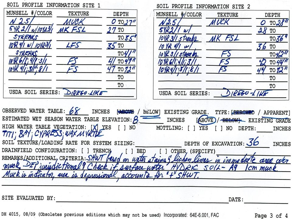
EXAMPLE 5. MUCK SOIL SURFACE (SAMPLE IN SW FL)
")
84
N 2.5/ MUCK 0-4” 5Y 4/1 FS 4-6” 5Y 7/1;8/1 FS 6-15” 10BG 6/1 FS ” Refusal Refusal 22-22” REFUSAL DUE TO HOLE CAVING IN AND FILLING WITH WATER. REMARKS: MUCK IS THE SHWT, AS IT QUALIFIES AS HYDRIC SOIL INDICATOR A8 (MUCK PRESENCE). SITE IS LEVEL, NOT IN A DEPRESSION. ALSO OF NOTE IS STRIPPED MATRIX INDICATOR IS MET BEGINNING AT 6”, AND GLEYED MATRIX IS MET AT 15”.
. SITE IS LEVEL, NOT IN A DEPRESSION. ALSO OF NOTE IS STRIPPED MATRIX INDICATOR IS MET BEGINNING AT 6 , AND GLEYED MATRIX IS MET AT 15 .")
85
EXAMPLE 6: HYDROGEN SULFIDE SMELL

86
N 2.5/ FS 0-1” 5Y 4/1 FS 1-6” 5Y 7/1 FS 6-15” 10BG 6/1 SCL ” REFUSAL DUE TO HOLE CAVING IN AND FILLING WITH WATER REMARKS: HYDROGEN SULFIDE SMELL OBSERVED AT 2”, WHICH IS HYDRIC SOIL INDICATOR A4, HYDROGEN SULFIDE. ALSO OF NOTE IS GLEYED MATRIX IS MET AT 15”. SHWT 2”.

87
Anything wrong with the following profile?

89
Documentation of Lamellae

91
Redox features documented lower in soil profile

93
Example of SHWT above the ground surface

95
Did preceding slide meet a different HSI?
What about A1, Histosol? There was more than 16” of organic soil material.

96
What about soil texture determined by a lab analysis?
SHOULD YOU CALL THE LAB?

97
CAUTIONS ON LAB ANALYSIS
MAKE SURE THAT THE RESULTS ARE UNDERSTOOD! WHAT METHODS WERE USED? SIEVE ANALYSIS USING CORRECT USDA SIEVE STACK INCLUDED? HYDROMETER OR PIPETTE METHOD? THE RESULTS MUST ACCOUNT FOR SAND GRADATION AS WELL AS SILT/CLAY CONTENT

98
Example CHD sends a sample to an agricultural lab and asks for a texture determination Sample comes back as percent Sand/Silt/Clay so that the result could be read on the Textural Triangle. Result was given as Sandy Loam. The size of the sand had not been determined, so it is unknown if sample is COSL, SL, FSL, VFSL. The actual sand fragments would determine proper sizing of system. This could be done in the field. Accepting this lab report at face value would be a mistake.

99
Results if CHD accepted the soil as sandy loam?
NO EFFECT ON REDOX FEATURES, SHWT WOULD BE UNAFFECTED. IF THE SOIL TYPE WAS ACTUALLY FINE SANDY LOAM THE DRAINFIELD WOULD BE UNDERSIZED BY OVER 23 PERCENT!!

100
When supplying soils samples to (or receiving results from) a lab always ensure a complete texture determination is made. This must include a proper USDA NRCS sieve analysis to determine the sand fraction size.

101
Lab Analysis continued
If particles >2mm are present in sufficient quantities to require a “gravelly” or other modifier, ensure that the lab analysis provides this data. CHD personnel should make every effort to get a sample for their use and determine if the sample has particles larger than soil particles, as well as the correct sand size.

102
Lab Analysis continued
If at any time the CHD is not sure if the lab analysis is consistent with what is on the site, you should call the lab, or take your own sample and send it to the lab.

103
END OF PRESENTATION

Similar presentations