Download presentation
Presentation is loading. Please wait.

1
Lecture 3/4 topics Biomes (what the heck are those?)
Global and local Gradients (physical and biological) How plants grow Productivity and biomass – importance in production forestry and carbon sequestration
 How plants grow. Productivity and biomass – importance in production forestry and carbon sequestration.")
2
Week 2 Learning Objectives
You should be able to: Recognize characteristics and general distribution of biomes and what factors influence their spatial coverage Describe difference between biome based on actual cover and potentialcover (spatially and temporally) Describe various biome/life zone types (globally and locally) and their productivity Understand spatial variation (gradients) in forest types (e.g., elevation, latitude, disturbance, temperature, precipitation) Describe basic photosynthesis and plant productivity (gross primary productivity, net primary productivity, differences in plant requirements) Understand the role of vegetation in carbon storage (sequestration) Think about spatial and temporal differences in ecosystems
 Describe various biome/life zone types (globally and locally) and their productivity. Understand spatial variation (gradients) in forest types (e.g., elevation, latitude, disturbance, temperature, precipitation) Describe basic photosynthesis and plant productivity (gross primary productivity, net primary productivity, differences in plant requirements) Understand the role of vegetation in carbon storage (sequestration) Think about spatial and temporal differences in ecosystems.")
3
How can we tell different biomes apart?
THE CONCEPT OF BIOMES Biome: a major regional community of plants and animals with similar life forms and environmental conditions. It is the largest geographical biotic unit. How can we tell different biomes apart? Generally named after the dominant type of life form (normally vegetation in terrestrial systems), such as tropical rain forest, grassland, or coral reef.
, such as tropical rain forest, grassland, or coral reef.")
4
Vegetation serves many critical functions:
Produces oxygen via photosynthesis 2. Role in nutrient cycling and energy flows 3. Affects soil characteristics 4. Provides wildlife habitat and energy (food) source Produces food, wood, fuel and other materials for humans 6. Psychologically important to humans, who evolved in direct contact with, and dependence on, vegetation, for food, shelter, and medicine.
 source. Produces food, wood, fuel and other materials for humans. 6. Psychologically important to humans, who evolved in direct contact with, and dependence on, vegetation, for food, shelter, and medicine.")
5
Much of the work on vegetation classification comes from European and North American ecologists, and they have fundamentally different approaches. North America based on a combination of the following criteria: climate pattern, plant habit, phenology and/or growth form, and dominant species. Europe, classification relies heavily on species composition alone, without explicit reference to climate, phenology or growth forms.

6
Factor for defining biomes
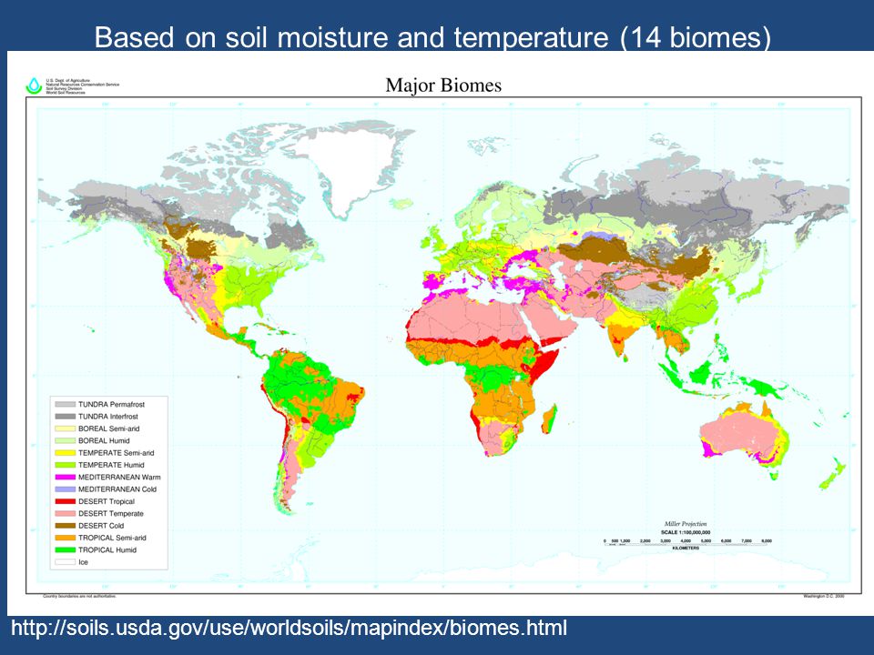
Biomes are defined based on factors such as: plant structures (such as trees, shrubs, and grasses), leaf types (such as broadleaf and needleleaf), plant spacing (forest, woodland, savanna), and other factors like climate, soils, etc. Example systems Udvardy system -1975 Bailey system World Wildlife fund – 14 biomes, 852 ecoregions
, leaf types (such as broadleaf and needleleaf), plant spacing (forest, woodland, savanna), and other factors like climate, soils, etc. Example systems. Udvardy system Bailey system World Wildlife fund – 14 biomes, 852 ecoregions.")
7
Five Major Biomes Aquatic Forest Desert Grassland Tundra
Five Major Biomes Aquatic Forest Desert Grassland Tundra earthobservatory.nasa.gov

8
8 major biomes Physical Geography of the Global Environment, 2nd Edition, by H. J. De Blij, et al; 1998

9
14 major biomes

10
WWF system World Wildlife Fund (WWF) developed an ecological land classification system that identified 14 biomes, called major habitat types, and further divided the world's land area into 825 terrestrial ecoregions. This classification is used to define the list of ecoregions identified by the WWF as priorities for conservation. Tundra(arctic) Boreal forests/taiga (subarctic, humid) Temperate coniferous forests (temperate, humid to semi-humid) Temperate broadleaf and mixed forests (temperate, humid) Temperate grasslands, savannas, and shrublands (temperate, semi-arid) Mediterranean forests, woodlands, and shrub (temperate warm, semi-humid to semi- arid with winter rainfall) Tropical and subtropical coniferous forests (tropical and subtropical, semi-humid) Tropical and subtropical moist broadleaf forests (tropical and subtropical, humid) Tropical and subtropical dry broadleaf forests (tropical and subtropical, semi-humid) Tropical and subtropical grasslands, savannas, and shrublands (tropical and subtropical, and semi-arid) Montane grasslands and shrublands (alpine or montane climate) Deserts and xeric shrublands (temperate to tropical, arid) Mangrove (subtropical and tropical, salt water inundated) Flooded grasslands and savannas (temperate to tropical, fresh or brackish water inundated)
 developed an ecological land classification system that identified 14 biomes, called major habitat types, and further divided the world s land area into 825 terrestrial ecoregions. This classification is used to define the list of ecoregions identified by the WWF as priorities for conservation. Tundra(arctic) Boreal forests/taiga (subarctic, humid) Temperate coniferous forests (temperate, humid to semi-humid) Temperate broadleaf and mixed forests (temperate, humid) Temperate grasslands, savannas, and shrublands (temperate, semi-arid) Mediterranean forests, woodlands, and shrub (temperate warm, semi-humid to semi- arid with winter rainfall) Tropical and subtropical coniferous forests (tropical and subtropical, semi-humid) Tropical and subtropical moist broadleaf forests (tropical and subtropical, humid) Tropical and subtropical dry broadleaf forests (tropical and subtropical, semi-humid) Tropical and subtropical grasslands, savannas, and shrublands (tropical and. subtropical, and semi-arid) Montane grasslands and shrublands (alpine or montane climate) Deserts and xeric shrublands (temperate to tropical, arid) Mangrove (subtropical and tropical, salt water inundated) Flooded grasslands and savannas (temperate to tropical, fresh or brackish water inundated)")
11
In 1975, Miklos Udvardy published a system of 12 terrestrial biomes:
Tropical humid forests Subtropical and temperate rainforests or woodlands Temperate broad-leaf forests or woodlands and subpolar deciduous thickets Temperate needle-leaf forests or woodlands Evergreen sclerophyllous forests, scrub, or woodlands Tropical dry or deciduous forests (including Monsoon forests) or woodlands Temperate grasslands Warm deserts and semideserts Cold-winter (continental) deserts and semideserts Tundra communities and barren Arctic deserts Mixed mountain and highland systems with complex zonation Mixed island systems
 or woodlands. Temperate grasslands. Warm deserts and semideserts. Cold-winter (continental) deserts and semideserts. Tundra communities and barren Arctic deserts. Mixed mountain and highland systems with complex zonation. Mixed island systems.")
12
Based on soil moisture and temperature (14 biomes)
13
Kuchler

14
Interior Douglas fir Puget Sound Douglas fir Mountain hemlock Sitka
Spruce Western Hemlock Grand fir Silver fir Oak Subalpine fir Ponderosa pine

15
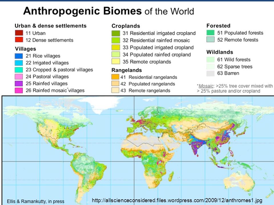
http://allscienceconsidered. files. wordpress. com/2009/12/anthromes1
16
Humans are major forces in ecosystem structure and function
We consume one third of all terrestrial net primary production, We move more earth and produce more reactive nitrogen than all other terrestrial processes combined, We are causing global extinctions and changes in climate that are comparable to any observed in the natural record

17
Rexford F. Daubenmire, 85, professor emeritus of botany at Washington State University, died August 26, 1995 at his home in Mt Plymouth, Florida. He was one of the nation's foremost authorities on plant ecology. Daubenmire's classification of forest and gressland vegetation in the Pacific Northwest became a standard management tool for both government agencies and the timber industry of the West. Considered radical when introduced in the early 1950's, his classification scheme emphasized the potential vegetation of a site, rather than existing vegetation that often had been altered through fire, logging and grazing. He also made lasting contributions in explaining the environmental restrictions that determine the range of tree species, ecological succession, the migration history of plant species in North America, and the role of fire in shaping many plant communities.

19
mora/archaeology/chap2b.htm

20
cses.washington.edu

21
maps101.com

23
Biome subdivisions Life Zones (e.g., Merriam 1889, Holdridge 1947) based on observed differences in plant and animal communities that change with physical characteristics Temperature, latitude, elevations, precipitation, etc. Ecoregion- (e.g., Bailey 1995, World Wildlife Fund) ecoregions have similar latitudinal and continental locations and are defined by the processes that produce them. The divisions are more specific than biomes, taking into account biogeographical divisions.
 based on observed differences in plant and animal communities that change with physical characteristics. Temperature, latitude, elevations, precipitation, etc. Ecoregion- (e.g., Bailey 1995, World Wildlife Fund) ecoregions have similar latitudinal and continental locations and are defined by the processes that produce them. The divisions are more specific than biomes, taking into account biogeographical divisions.")
24
Holdrige Life Zones Based on biotemperature, precipitation, potential evapotranspiration, and humidity earthscienceeducation.org

25
Ecoregions – started by the US Forest Service in 1978,
The technique of mapping ecoregions was subsequently expanded to include the rest of North America and the world. In 1993, as part of the Forest Service's National Hierarchical Framework of Ecological Units (ECOMAP).ecoregions were adopted for use in ecosystem management. Robert G. Bailey developed a biogeographical classification system for the United States in a map published in Bailey subsequently expanded the system to include the rest of North America in 1981, and the world in The Bailey system is based on climate, and is divided into four domains (Polar, Humid Temperate, Dry, and Humid Tropical), with further divisions based on other climate characteristics (subarctic, warm temperate, hot temperate, and subtropical, marine and continental, lowland and mountain).
.ecoregions were adopted for use in ecosystem management. Robert G. Bailey developed a biogeographical classification system for the United States in a map published in Bailey subsequently expanded the system to include the rest of North America in 1981, and the world in The Bailey system is based on climate, and is divided into four domains (Polar, Humid Temperate, Dry, and Humid Tropical), with further divisions based on other climate characteristics (subarctic, warm temperate, hot temperate, and subtropical, marine and continental, lowland and mountain).")
26
Bailey

27
Bailey

28
Bailey

29
b. Physiognomic (or structural – height and spacing of the vegetation) –based on general appearance, dominant life forms, layered structure of plant communities i UNESCO – hierarchical system ii. Current US standard (adopted by the Federal Geographic Data Committee (FGDC), and originally developed by UNESCO and The Nature Conservancy), the classification is hierarchical : system, class, subclass, group, formation, alliance, and association. The lowest level, or association, is thus the most precisely defined, and incorporates the names of the dominant one to three (usually two) species of the type. In practice, the levels of the alliance and/or association are the most often used, particularly in vegetation mapping, just as the Latin binomial is most often used in discussing particular species in taxonomy and in general communication.
, and originally developed by UNESCO and The Nature Conservancy), the classification is hierarchical : system, class, subclass, group, formation, alliance, and association. The lowest level, or association, is thus the most precisely defined, and incorporates the names of the dominant one to three (usually two) species of the type. In practice, the levels of the alliance and/or association are the most often used, particularly in vegetation mapping, just as the Latin binomial is most often used in discussing particular species in taxonomy and in general communication.")
30
Nature Conservancy Over the past twenty years, The Nature Conservancy has developed a science-based approach to conserving biological diversity. The Conservancy's approach to conservation science relies on the consistent and systematic accumulation, management, and analysis of information on the "elements of biological diversity" specifically the status and location of plants, animals, and ecological communities. National Vegetation Classification System The national vegetation classification system focuses on existing vegetation rather than potential natural vegetation, climax vegetation, or physical habitats. The vegetation types covered in the classification range from the short-lived to relatively stable and persistent plant communities. The classification includes natural, seminatural, modified, and cultural vegetation. Many regional classification schemes have been developed – For example, in the Pacific Northwest (Daubenmire, Franklin and Dyrness) and British Columbia
 and British Columbia.")
31
SAF Forest Cover Type for Western U.S.
code name 201White spruce 202 White spruce - paper birch 203 Balsam poplar 204 Black spruce 205 Mountain hemlock 206 Engelmann spruce – subalpine fir 207 Red fir 208 Whitebark pine 209 Bristlecone pine 210 Interior Douglas-fir 211 White fir 212 Western larch 213 Grand fir 215 Western white pine 216 Blue spruce 217 Aspen 218 Lodgepole pine 219 Limber pine 220 Rocky Mountain juniper 221 Red alder 222 Black cottonwood - willow 223 Sitka spruce 224 Western hemlock 225 Western hemlock - Sitka spruce 226 Coastal true fir - hemlock 227 Western redcedar - western hemlock 228 Western redcedar 229 Pacific Douglas-fir 230 Douglas-fir - western hemlock 231 Port Orford-cedar 232 Redwood

32
Example of US standard classification, through association level
System: Terrestrial/Aquatic - (hydrological regime) Class: Woodland - (spacing & height of dominant form) Subclass: Evergreen Woodland - (morphological & Phenological similarity) Group: Temperate Evergreen Needle-leaved - (climate latitude, growth form, leaf form) Formation: Evergreen needle-leaved forest with conical crowns - (mapable units) Alliance (or cover type): Abies lasiocarpa Forest (dominant species) Association (or community): Abies lasiocarpa/Vaccinium scoparium [Subalpine fir/Grouseberry] (subdominant or associated species with similar ecological processes)
 Class: Woodland - (spacing & height of dominant form) Subclass: Evergreen Woodland - (morphological & Phenological similarity) Group: Temperate Evergreen Needle-leaved - (climate latitude, growth form, leaf form) Formation: Evergreen needle-leaved forest with conical crowns - (mapable units) Alliance (or cover type): Abies lasiocarpa Forest (dominant species) Association (or community): Abies lasiocarpa/Vaccinium scoparium [Subalpine fir/Grouseberry] (subdominant or associated species with similar ecological processes)")
33
PNV is the "climax" vegetation that will occupy a site without disturbance or climatic change. PNV is an expression of environmental factors such as topography, soils and climate across an area. Where cover type is a classification of existing vegetation, PNV is a site classification based on climax vegetation. Because the existing cover type at any particular location and time may reflect a vegetation community anywhere along its successional pathway - from seral to climax - the cover type may be the same as the PNV. Terrain-matched refinement of Kuchler's Potential Natural Vegetation (PNV) map have been produced. Kuchler's PNV map was digitized for the conterminous United States, then adjusted to match terrain using a 500 m Digital Elevation Model, 4th Code Hydrologic Unit delineations, and Ecological Subregions (Bailey's Sections). These biophysical data layers were integrated with current vegetation layers, Resource Planning Act's Forest Types and Forest Densities of the United States, and USGS EROS Data Center's Land Cover Characterization database, to develop generalized successional pathway diagrams. Expert regional panels refined the PNV map based on these successional pathways.
 map have been produced. Kuchler s PNV map was digitized for the conterminous United States, then adjusted to match terrain using a 500 m Digital Elevation Model, 4th Code Hydrologic Unit delineations, and Ecological Subregions (Bailey s Sections). These biophysical data layers were integrated with current vegetation layers, Resource Planning Act s Forest Types and Forest Densities of the United States, and USGS EROS Data Center s Land Cover Characterization database, to develop generalized successional pathway diagrams. Expert regional panels refined the PNV map based on these successional pathways.")
34
Why classify biomes/vegetation?
Better communication among professionals Better understanding of ecosystem interactions Useful aid for land and natural resource management and monitoring , U.S. Forest Service, Forest Inventory Analysis (FIA) plots ( EPA Environmental Monitoring and Assessment Program (EMAP) IUCN Red List for Ecosystems ( Identify the presence of invasive species Ecosystem health issues – climate change, fire effects
 plots ( EPA Environmental Monitoring and Assessment Program (EMAP) IUCN Red List for Ecosystems ( Identify the presence of invasive species. Ecosystem health issues – climate change, fire effects.")
35
Wildlife reintroduction Climate change predictions of distribution
How can the classifications be used? Corridors Wildlife reintroduction Climate change predictions of distribution Plant restoration

36
Scoring for restoration opportunities
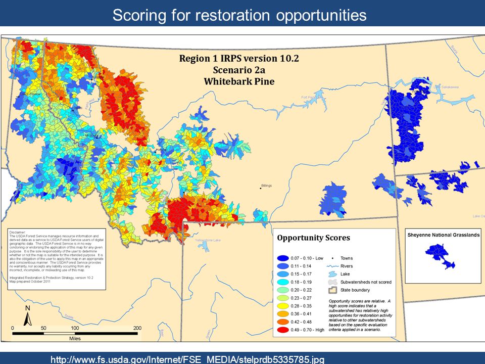
37
Figure 2. Planning unit cost based on naturalness.
Less natural Columbia Plateau Schloss CA, Lawler JJ, Larson ER, Papendick HL, et al. (2011) Systematic Conservation Planning in the Face of Climate Change: Bet-Hedging on the Columbia Plateau. PLoS ONE 6(12): e doi: /journal.pone
 Systematic Conservation Planning in the Face of Climate Change: Bet-Hedging on the Columbia Plateau. PLoS ONE 6(12): e doi: /journal.pone")
38
No universal classification scheme
Summary No universal classification scheme Based on various physical, chemical and biological characteristics and assemblages Some based on current vs. potential life forms Some include humans others do not Used for planning, management, restoration

Similar presentations


: any form of life – population: a group of interacting individuals of same species – community: populations.>")


