Download presentation
Presentation is loading. Please wait.

1
Chapter 13 Weathering, Karst Landscapes, and Mass Movement
Geosystems 5e An Introduction to Physical Geography Robert W. Christopherson Charlie Thomsen

2
Exogenic/Endogenic Systems
Chapter 13 begins the treatment of the exogenic system (internal processes that produce flows of heat and material from deep below the crust, powered by radioactive decay). This is the solid realm of Earth. . Chapters 11 and 12 covered the endogenic system. As the landscape is formed, a variety of exogenic processes simultaneously operate to wear it down. The endogenic system (external processes that set air, water (streams and waves), and ice into motion, powered by solar energy). This is the fluid realm of Earth's environment; it builds and creates initial landscapes, while the exogenic system works towards low relief, little change, and the stability of sequential landscapes. The distinction is shown in Figure 11-5:
. This is the solid realm of Earth. . Chapters 11 and 12 covered the endogenic system. As the landscape is formed, a variety of exogenic processes simultaneously operate to wear it down. The endogenic system (external processes that set air, water (streams and waves), and ice into motion, powered by solar energy). This is the fluid realm of Earth s environment; it builds and creates initial landscapes, while the exogenic system works towards low relief, little change, and the stability of sequential landscapes. The distinction is shown in Figure 11-5:")
3
Exogenic/Endogenic Systems

4
What is weathering? Have you noticed highways in mountainous in cold climates that appear rough and broken? Roads that experience freezing weather seem to pop-up in chunks each winter? Or, maybe you saw older marble structures, such as tombstones, etched and dissolved by rainwater? Similar physical and chemical weathering processes are important to the overall reduction of the landscape and the release of essential minerals from bedrock. A simple examination of soil gives evidence of weathered mineral grains from many diverse sources.

5
Key Learning Concepts for this Topic:
Define the science of geomorphology. Illustrate the forces at work on materials residing on a slope. Define weathering and explain the importance of parent rock and joints and fractures in rock. Describe frost action, crystallization, hydration, pressure-release jointing, and the role of freezing water as physical weathering processes. Describe the susceptibility of different minerals to the chemical weathering processes called hydrolysis, oxidation, carbonation, and solution. Review the processes and features associated with karst topography. Portray the various types of mass movements and identify examples of each in relation to moisture content and speed of movement

6
1. What is geomorphology and what is its relationship with physical geography?
Geomorphology is a science that analyzes and describes the origin, evolution, form, and spatial distribution of landforms. It is an important aspect of the study of physical geography and the understanding of the spatial-physical aspects of landforms. An interesting example of geomorphology is the Grand Canyon of Arizona: the erosional processes that reduce a landscape like the Grand Canyon are balanced against the resistance of the materials that make up the landscape. Weathering and erosional forces naturally oscillate, especially in the desert, with high rainfall variability coming in episodic thunderstorms. Each rainfall event at the Grand Canyon operates on available slopes and cliffs. The river receives materials and discharges its flow of water and sediment load. The variation in rock resistance is responsible for the cliffs and slopes in the rock: more resistant rock cliffs, less resistant rock slopes.

7
2. Define landmass denudation
2. Define landmass denudation. What processes are included in the concept? Denudation is a general term referring to all processes that cause reduction or rearrangement of landforms. The principal denudation processes affecting surface materials include weathering, mass movement, erosion, transportation, and deposition.

8
3. What is the interplay between the resistance of rock structures and weathering variabilities?
Weathering is greatly influenced by the character of the bedrock: hard or soft, soluble or insoluble, broken or unbroken. The differing resistance of rock, coupled with these variations in the intensity of weathering, result in differential weathering. Interactions between the structural elements of the land and denudation processes are complex, and represent a constant struggle between internal and external processes. An important question to ask is whether or not this dynamic interplay is progressive, evolving and building landforms in an orderly manner through stages? Do landscapes initially form and subsequently age in graceful stages until they are flat? Or does the interplay of forces fluctuate back and forth across a never achieved steady-state equilibrium? The debates in geomorphology are fueled by the fact that landscapes evolve on a much longer time span than does a human life, or a research grant, or thesis project, or the edition of a textbook. Modern geomorphology has moved away from simple descriptive classifications.

9
4. A brief overview of the geomorphic cycle model; What was W. M
4. A brief overview of the geomorphic cycle model; What was W. M. Davis’ principal contribution to the models of landmass denudation? Davis theorized that a landscape goes through an initial uplift that is accompanied by little erosion or removal of materials and then enters a prolonged period of stability -an idea he later modified. The raised elevation of the landscape is such that streams begin flowing more rapidly downhill, cutting both headward (upstream) and downward. According to this cyclic model, the landscape eventually evolves into an old erosional surface. But Davis's theory, although it helped launch the science of geomorphology and was innovative at the time, was too simple and did not account for the processes being observed as systems theory entered geomorphology. Although not generally accepted today, his thinking about the evolution of landscapes is still influential.
 and downward. According to this cyclic model, the landscape eventually evolves into an old erosional surface. But Davis s theory, although it helped launch the science of geomorphology and was innovative at the time, was too simple and did not account for the processes being observed as systems theory entered geomorphology. Although not generally accepted today, his thinking about the evolution of landscapes is still influential.")
10
5. What are the principal considerations in the dynamic equilibrium model?
The balancing act between tectonic uplift and reduction by weathering and erosion, between the resistance of rocks and the ceaseless attack of weathering and erosion, is summarized in the dynamic equilibrium model. The dynamic equilibrium model is a balancing act between tectonic uplift and erosion, between the resistance of crust materials and the work of denudation processes. Landscapes evidence ongoing adaptation to rock structure, climate, local relief, and elevation. A dynamic equilibrium demonstrates a trend over time. Endogenic events (such as earthquakes and volcanic eruptions), or exogenic events (such as heavy rainfall or forest fire), may provide new sets of relationships for the landscape.
, or exogenic events (such as heavy rainfall or forest fire), may provide new sets of relationships for the landscape.")
11
6. Describe conditions on a hillslope that is right at the geomorphic threshold.
As changing conditions provide new sets of relationships for the landscape, the system eventually arrives at a geomorphic threshold, or that point at which the system breaks through to a new set of equilibrium relationships and rapidly realigns landscape materials accordingly. Slopes, as parts of landscapes, are open systems and seek an angle of equilibrium among the forces described here. Conflicting forces work together on slopes to establish an optimum compromise incline that balances these forces. A geomorphic threshold (change point) is reached when any of the conditions in the balance is altered. Many factors could alter the hillside's equilibrium, such as an earthquake, or the building of a house or dam (adding mass). All the forces on the slope then compensate by adjusting to a new dynamic equilibrium. (See next slide).
 is reached when any of the conditions in the balance is altered. Many factors could alter the hillside s equilibrium, such as an earthquake, or the building of a house or dam (adding mass). All the forces on the slope then compensate by adjusting to a new dynamic equilibrium. (See next slide).")
12
Figure 13.2: A slope in disequilibrium
The disturbed hillslope in Figure 13.2 is in the midst of compensating adjustment. The failure of saturated slopes caused a landslide into the river and set a disequilibrium condition. As a consequence, the new dam of material threw the stream into disequilibrium between its flow and sediment load.

13
7. What factors might push a slope beyond its geomorphic threshold ?
Slopes seek an angle of equilibrium among the forces described in the text (Figure 13-3). In other words, slopes exhibit maximum inclines that balance conflicting forces. A geomorphic threshold (change point) is reached if one of the conditions in the balance alters. When this occurs all the forces on the slope compensate by adjusting to a new dynamic equilibrium. A slope is an open system responding to variable inputs and producing variable outputs.
. In other words, slopes exhibit maximum inclines that balance conflicting forces. A geomorphic threshold (change point) is reached if one of the conditions in the balance alters. When this occurs all the forces on the slope compensate by adjusting to a new dynamic equilibrium. A slope is an open system responding to variable inputs and producing variable outputs.")
14
Angle of equilibrium among the geomorphic forces (Figure 13:3)
")
15
8. What are the general components of an ideal slope?
Figure 13-3b illustrates basic slope components that vary with conditions of rock structure and climate. Slopes generally feature an upper waxing slope near the top. The convex surface curves downward and grades into the free face below. The presence of a free face indicates an outcrop of resistant rock that forms a steep scarp or cliff. Downslope form the free face is a debris slope, which receives rock fragments and materials from above. The debris slope grades into a waning slope, concave surface along the base of the slope. This surface of erosional materials gently slopes at a continuously decreasing angle to the valley floor. A slope is an open system seeking an angle of equilibrium. Conflicting forces work simultaneously on slopes to establish an optimum compromise incline that balances these forces.

16
Slope Mechanics (Figure 13.3B)
The relationship between rates of weathering and breakup of slope materials, coupled with the rates of mass movement and material erosion, shapes slopes. A slope is stable if its strength exceeds these denudation processes and unstable if materials are weaker than these processes.

17
10. Describe weathering processes operating on an open expanse of bedrock. How does regolith develop? How is sediment derived? Rocks at or near Earth's surface are exposed to both physical and chemical weathering processes. Weathering encompasses a group of processes by which surface and subsurface rock disintegrates into mineral particles or dissolves into minerals in solution. Weathering does not transport the weathered materials; it simply generates these raw materials for transport by the agents of wind, water, and gravity. In most areas, the upper surface of bedrock is partially weathered to broken-up rock called regolith. In some areas, regolith may be missing or undeveloped, thus exposing an outcrop of unweathered bedrock. Loose surface material comes from further weathering of regolith and from transported and deposited regolith. This unconsolidated sediment and weathered rock forms the parent material from which soil evolves. When rock is broken and disintegrated without any chemical alteration, the process is called physical weathering or mechanical weathering. By breaking up rock, physical weathering greatly increases the surface area on which chemical weathering may operate. Chemical weathering refers to actual decomposition and decay of the constituent minerals in rock due to chemical alteration of those minerals. A familiar example of chemical weathering is the eating away of cathedral facades and etchings on tombstones caused by increasingly acid precipitation.

18
11. Describe the relationship between mesoscale climatic conditions and rates of weathering activities. Important in determining weathering rates are climatic elements, including the amount of precipitation, overall temperature patterns, and any freeze-thaw cycles. Physical weathering dominates in drier, cooler climates, whereas chemical weathering dominates in wetter, warmer climates. Extreme dryness reduces most weathering to a minimum, as is experienced in desert climates (BW). In the hot, wet-tropical and equatorial rainforest climates (Af), most rocks weather rapidly, and the weathering tends to be deep below the surface.
. In the hot, wet-tropical and equatorial rainforest climates (Af), most rocks weather rapidly, and the weathering tends to be deep below the surface.")
19
12. What is the relation among parent rock, parent material, regolith and soil?
Bedrock is the parent rock from which weathered regolith (partially weathered rock overlaying bedrock, whether residual or transported) and soils develop. While a soil is relatively youthful, its parent rock is traceable through similarities in composition. This unconsolidated fragmental material, known as sediment, combines with weathered rock to form the parent material from which soil evolves. See Figure 13-5.
 and soils develop. While a soil is relatively youthful, its parent rock is traceable through similarities in composition. This unconsolidated fragmental material, known as sediment, combines with weathered rock to form the parent material from which soil evolves. See Figure")
20
13. What is physical weathering? Give an example.
Physical, or mechanical, weathering is the term used when rock is broken and disintegrated without any chemical alteration. By breaking up rock, physical weathering greatly increases the surface area on which chemical weathering can take place. An example of physical weathering is frost action. When water freezes, its volume expands. This creates a powerful mechanical force, which can exceed the tensional strength of rock. Repeated freezing and thawing of water break rocks apart. The work of ice begins in small openings, such as existing joints and fractures, gradually expanding until rocks are split apart.

21
14. Why is freezing water such an effective physical weathering agent?
Water expands by as much as 9% of its volume as it freezes. This expansion creates a powerful mechanical force that can exceed the tensional strength of rock. In a weathering action called frost-wedging, ice crystals grow in preexisting cracks in rock and push the sides apart along joints or fractures. The work of ice probably begins in small openings, gradually expanding until rocks are cleaved. Softer supporting rock underneath the slabs already has weathered physically–an example of differential weathering.

22
15. What is chemical weathering
15. What is chemical weathering? Contrast this set of processes to physical weathering. Chemical weathering is the actual decomposition of minerals in rock. Chemical weathering involves reactions between air and water and minerals in rock. Minerals may combine with water in chemical reactions (such as carbonation), or carbon dioxide and oxygen from the atmosphere (such as oxidation). Although physical weathering may create greater surface area for further weathering to take place, chemical weathering can dissolve minerals throughout the rock. An example that demonstrates the difference between physical and chemical weathering is the absorption of water in rocks. In cold climates dominated by physical weathering, the process of hydration takes place. In hydration water present in the rock expands with freezing and cracks the rock into smaller pieces. In humid climates, where chemical weathering occurs, water percolates into the rock, a process called hydrolysis, and breaks down the silicate minerals in rock. Hydrolysis dissolves silicate materials leaving behind resistant minerals, such as quartz.
, or carbon dioxide and oxygen from the atmosphere (such as oxidation). Although physical weathering may create greater surface area for further weathering to take place, chemical weathering can dissolve minerals throughout the rock. An example that demonstrates the difference between physical and chemical weathering is the absorption of water in rocks. In cold climates dominated by physical weathering, the process of hydration takes place. In hydration water present in the rock expands with freezing and cracks the rock into smaller pieces. In humid climates, where chemical weathering occurs, water percolates into the rock, a process called hydrolysis, and breaks down the silicate minerals in rock. Hydrolysis dissolves silicate materials leaving behind resistant minerals, such as quartz.")
23
16. What is meant by the term spheriodal weathering
16. What is meant by the term spheriodal weathering? How is spheroidal weathering formed? Spheroidal weathering is an example of the way chemical weathering attacks rock. The sharp edges and corners of rock are rounded as the alteration of minerals progresses through the rock. Joints in the rock offer more surfaces of opportunity for weathering. Water penetrates joints and fractures and dissolves the rock's weaker minerals or cementing materials. The resulting rounded edges are the basis for the name spheroidal weathering.

24
17. What is hydrolysis? How does it affect rocks?
When minerals chemically combine with water, the process is called hydrolysis. Hydrolysis is a decomposition process that breaks down silicate minerals in rocks. Water is not simply absorbed in hydrolysis but actively participates in chemical reactions to produce different compounds and minerals.

25
18. Iron minerals in rock are susceptible to which form of chemical weathering? What characteristic color is associated with this type of weathering? Iron minerals in rock are susceptible to oxidation. Oxidation is an example of chemical weathering that occurs when oxygen combines with certain metallic minerals to form oxides. The rusting of iron in rocks or soils produces a reddish-brown stain of iron oxide. – (Example of what planet?????)
")
26
19. With what kind of minerals do carbon compounds react, and under what circumstances does this reaction occur? What is this weathering process called? Carbon compounds react with carbonic acid, created when water vapor dissolves carbon dioxide. Carbonic acid is strong enough to react with many minerals, especially limestone, in a process known as carbonation. When rainwater attacks formations of limestone, the constituent minerals are dissolved and wash away with the mildly acidic rainwater.

27
20. Describe the development of limestone topography
20. Describe the development of limestone topography. What is the name applied to such landscapes? From what was this name derived? Limestone is so abundant on Earth that many landscapes are composed of it. These areas are quite susceptible to chemical weathering. Such weathering creates a specific landscape of pitted, bumpy surface topography, poor surface drainage, and well-developed solution channels underground. Remarkable labyrinths of underworld caverns also may develop. These are the hallmarks of karst topography, originally named for the Krs Plateau in the former Yugoslavia, where these processes were first studied. Approximately 15% of Earth's land area has some developed karst, with outstanding examples found in southern China, Japan, Puerto Rico, Cuba, the Yucatán of Mexico, Kentucky, Indiana, New Mexico, and Florida.

28
Limestone and Karst regions: (Figure 13.14)
")
29
21. What are some of the unique erosional and depositional features you find in a limestone cavern?

30
Conditions Necessary for Karst:
Limestone must contain 80% or more of CaCO3. Joints, cracks, pipes, and other openings must exist for water to flow. Must be an aerated zone between the ground surface and the water table. Some vegetation must occur to add organic acids to downward percolating water.

32
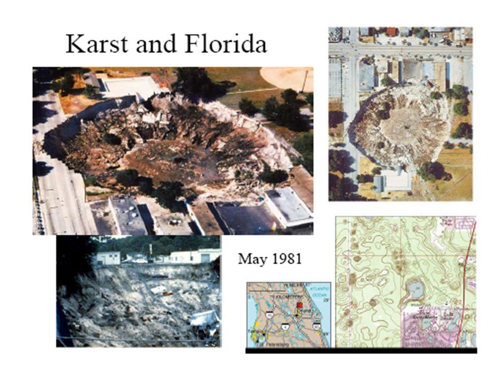
Karst and Florida

33
22. Define the role of slopes in mass movements, using the terms angle of repose, driving force, resisting force, and geomorphic threshold. All mass movements occur on slopes. The steepness of a slope determines where loose material comes to rest, depending on the size and texture of the grains; this is called the angle of repose. This angle represents a balance of driving and resisting forces. The driving force in mass movements is gravity, working in conjunction with the weight, size, and shape of the grains or surface material, the degree to which the slope is oversteepened, and the amount and form of moisture available–whether frozen or fluid. The greater the slope angle, the more susceptible the surface material is to mass movement. The resisting force is the shearing strength of slope material, that is, its cohesiveness and internal friction working against mass movement. To reduce shearing strength is to increase shearing stress, which eventually reaches the point at which gravity overcomes friction. Geomorphic threshold is the threshold up to which landforms change before lurching to a new set of relationships, with rapid realignments of landscape materials and slopes.

34
23. What are the classes of mass movement (wasting)
23. What are the classes of mass movement (wasting)? [mass wasting movie at the end of chapter]. What is rockfall? Four basic classifications of mass movement are used: fall, slide, flow, and creep. Each involves the pull of gravity working on a mass until the critical shearing strength is reduced to the point that the mass falls, slides, flows, or creeps downward. A rockfall is simply a quantity of rock that falls through the air and hits a surface. During a rockfall, individual pieces fall independently, and characteristically form a pile of irregular broken rocks called a talus cone at the base of a steep cliff.
 [mass wasting movie at the end of chapter]. What is rockfall Four basic classifications of mass movement are used: fall, slide, flow, and creep. Each involves the pull of gravity working on a mass until the critical shearing strength is reduced to the point that the mass falls, slides, flows, or creeps downward. A rockfall is simply a quantity of rock that falls through the air and hits a surface. During a rockfall, individual pieces fall independently, and characteristically form a pile of irregular broken rocks called a talus cone at the base of a steep cliff.")
35
24. Name and describe the type of mudflow associated with a volcanic eruption.
The hot eruption of Nevado del Ruiz in central Colombia, South America, melted about 10% of the ice on the mountain's snowy peak, liquefying mud and volcanic ash, and sending a hot mudflow downslope. Such a flow is called a lahar, an Indonesian word referring to flows of volcanic origin. The Mount Saint Helens eruption also produced a lahar in the Toutle River valley.

36
25. What is scarification, and why is it considered a type of mass movement? Give several examples of scarification. Why are humans a significant geomorphic agent? Large open-pit strip mines–such as the Bingham Copper Mine west of Salt Lake City, the Berkeley Pit in Butte, Montana, and the extensive strip mining for coal in the East and West, are examples of human-induced mass movements, generally called scarification. At the Bingham Copper Mine, a mountain literally was removed (see next slide). The disposal of tailings and waste material is a significant problem with such large excavations because the tailing piles prove unstable and susceptible to further weathering, mass wasting, or wind dispersal.
. The disposal of tailings and waste material is a significant problem with such large excavations because the tailing piles prove unstable and susceptible to further weathering, mass wasting, or wind dispersal.")
37
Fig. 13.28: Scarification by Strip Mining.

38
Movie: Mass Wasting Mass wasting: the downslope movement of earth under the influence of gravity. Various factors in mass wasting are discussed, including the rock’s effective strength and pore spaces, as well as different types of mass wasting such as creep, slump, and landslides. Images of an actual landslide illustrate the phenomenon.

39
Geosystems 5e An Introduction to Physical Geography
End of Chapter 13 Geosystems 5e An Introduction to Physical Geography Robert W. Christopherson Charlie Thomsen

Similar presentations


 Sun provides heat energy Hydrologic cycle.>")


 and chemical alteration (decomposition)>")