Download presentation
Presentation is loading. Please wait.

1
COASTAL DYNAMICS VIRTUAL FIELD TRIP, NORTHEAST FLORIDA
Joann Mossa Department of Geography University of Florida

2
WHERE ARE WE GOING? 1 2 In NE Florida (Flagler and St. Johns County, south of St. Augustine), we will visit Matanzas Inlet, Marineland, and Washington Oaks Gardens State Park If you have Google Earth software (free download at you can type in these locations We will first visit the north side of the inlet to compare the ocean side and the lagoon side of the island Inlets are fun places to visit because they are very dynamic Matanzas Inlet St. Johns Co. 3 Marineland Flagler Co. 4
, we will visit Matanzas Inlet, Marineland, and Washington Oaks Gardens State Park. If you have Google Earth software (free download at you can type in these locations. We will first visit the north side of the inlet to compare the ocean side and the lagoon side of the island. Inlets are fun places to visit because they are very dynamic. Matanzas Inlet. St. Johns Co. 3. Marineland. Flagler Co. 4.")
3
PARK HERE AND GO OVER THE DUNE WALKWAY TO THE BEACH
X This is a 1999 color infrared DOQQ (digital ortho quarter quad) Healthy dense vegetation appears red
 Healthy dense vegetation appears red.")
4
THIS IS THE FIRST SIGN THAT YOU SEE
THIS IS THE FIRST SIGN ON THE WALKWAY TO THE BEACH THIS IS THE FIRST SIGN THAT YOU SEE So true! Go to a developed beach without walkways on Google Earth (such as Daytona Beach or Fort Lauderdale) and there will be a lot less vegetation.
 and there will be a lot less vegetation.")
5
THIS OBLIQUE AERIAL PHOTOGRAPH OF THE INLET IS ON THE WALKWAY (THE RED CIRCLE SHOWS WHERE WE ARE)
")
6
WIND-VEGETATION INTERACTIONS
WALKWAY ABOVE DUNES This portion of the walkway is oriented perpendicular to the beach. The walkway is elevated to allow migration of dunes and addition of new sediment by wind (eolian) activity. Vegetation causes the wind velocity to decrease near the land surface, which in turn causes the sand to drop out of suspension Vegetation also keeps dune sand in place, thus it promotes dune stability in different ways
 activity. Vegetation causes the wind velocity to decrease near the land surface, which in turn causes the sand to drop out of suspension. Vegetation also keeps dune sand in place, thus it promotes dune stability in different ways.")
7
The walkway then turns so it is parallel to the beach
The walkway then turns so it is parallel to the beach. The primary dune or foredune in front of the walkway is generally the highest part of the barrier, but there are other ridges behind it.

8
HEAVY MINERALS IN SAND Sand refers to a particular size of sediment with a diameter between 1/16 mm and 2 mm. The dominant mineral in beach sand in Florida is quartz. It is more resistant to weathering than most minerals. Quartz is clear to white in color. Some other minerals appear black in comparison. These are heavy minerals (denser than quartz) and help show layering in the dune. Heavy minerals from old beach deposits in central Florida are being mined for use in paints and other products.
 and help show layering in the dune. Heavy minerals from old beach deposits in central Florida are being mined for use in paints and other products.")
9
BEACH-DUNE INTERACTIONS
Do you see the scarp (steep slope, elevation differential) in front of the dunes? The scarp forms when dunes are eroded during storms. The sediment from the dunes helps the beach recover from storms For dunes to form, there needs to be a force (winds of sufficient velocity), source (beach sand) and place (wide enough island). Construction/land use can adversely impact beach-dune interactions. (FYI…the scarp can also be seen on Google Earth, which better depicts erosion from recent storms)
 in front of the dunes The scarp forms when dunes are eroded during storms. The sediment from the dunes helps the beach recover from storms. For dunes to form, there needs to be a force (winds of sufficient velocity), source (beach sand) and place (wide enough island). Construction/land use can adversely impact beach-dune interactions. (FYI…the scarp can also be seen on Google Earth, which better depicts erosion from recent storms)")
10
OBSERVING EROSION AND DEPOSITION
What evidence is there of erosion in this photo? (hint: do you see a portion of the scarp?) What evidence of deposition? (hint: look at the railing of the walkway)
 What evidence of deposition (hint: look at the railing of the walkway)")
11
DUNE DEPOSITION The dune is migrating onto the walkway and even stabilized with vegetation. While not ideal, the walkway still allows for pedestrian traffic.

12
SAND STREAMERS ON A WINDY DAY
These white streaks oriented oblique to the beach (not the tire marks) are sand streamers. Also known as sand snakes, streamers reflect spatial and temporal clustering of wind blown sand over sedimentary surfaces. These are likely governed by internal variations in the near-surface wind field. SAND STREAMERS ON A WINDY DAY
 are sand streamers. Also known as sand snakes, streamers reflect spatial and temporal clustering of wind blown sand over sedimentary surfaces. These are likely governed by internal variations in the near-surface wind field. SAND STREAMERS ON A WINDY DAY.")
13
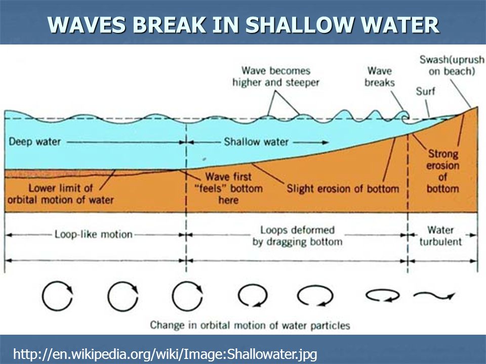
WAVES AND BREAKERS Waves are formed in deep water and travel to shore. Their height is influenced by wind speed, wind duration, and fetch (distance across which the wind blows). As they move into shallower water, they change direction (becoming more parallel to the shore), wave height increases, length decreases and they break. The center of the photograph shows a plunging breaker.
. As they move into shallower water, they change direction (becoming more parallel to the shore), wave height increases, length decreases and they break. The center of the photograph shows a plunging breaker.")
14
WAVES BREAK IN SHALLOW WATER
15
THE SURF ZONE AND SWASH The surf zone is shoreward of the breaking waves. The uprush of water following wave breaking on the sloping front of the beach is known as swash.

16
SWASH, BACKWASH AND LONGSHORE DRIFT
SWASH AND BACKWASH Swash will cause sand and other light particles to be transported up the beach. The direction of the swash varies with the prevailing wind, whereas the backwash (return flow) is always perpendicular to the coastline. This may cause longshore drift (sediment movement parallel to the shore) as the sediment moves in a zig-zag pattern.
 is always perpendicular to the coastline. This may cause longshore drift (sediment movement parallel to the shore) as the sediment moves in a zig-zag pattern.")
17
BEACH SEDIMENTS Waves break up shells into smaller fragments, generally sand size and larger. Shell gives the beach a more orange-brown color, contrasting the white/tan quartz sand close to and in the dunes.

18
MATANZAS INLET Unvegetated sand is easily transported by dynamic processes (waves, wind, tides and currents) Inlets typically are more dynamic than most coastal areas because many of these processes operate there Let’s now check out the back of the island near this inlet From this photo, which side has a wider beach?

19
THE LAGOON SIDE: THINGS ARE DIFFERENT HERE
Lagoons behind barrier islands are generally long and narrow. In Florida, these have been called “rivers” (Matanzas River, Indian River, etc.), but lagoon is a more appropriate, universal term Note how the waves are lower due to smaller fetch
, but lagoon is a more appropriate, universal term. Note how the waves are lower due to smaller fetch.")
20
CURVED SHORELINES AT INLET LAGOONS
On sedimentary beaches, the shoreline is parallel to the waves At the inlet, sediment exchange due to tides and tidal currents is an important process More deposition happens on the lagoon side, because the lower energies cause sediments to drop out of suspension Deposition close to the inlet can produce a curved shoreline, as appears in this photo

21
DUNES ON LAGOON SIDE Look at how close the dunes are to the lagoon shoreline…this beach is a lot narrower

22
COLLECTING A SEDIMENT SAMPLE
COLLECTING A SEDIMENT SAMPLE FROM THE LAGOON COLLECTING A SEDIMENT SAMPLE Sure looks dark in that pail!

23
LET’S DUMP AND SPREAD IT TO SEE IF IT IS DIFFERENT!
Its darker (more organic matter from various sources) Its finer (has much more silt and clay associated with deposition in lower energy settings)
 Its finer (has much more silt and clay associated with deposition in lower energy settings)")
24
BAR This bar exposed at low tide is showing the nature of the lagoon sediments Finer (muddier), more organics, reflecting lower energy
, more organics, reflecting lower energy.")
25
RIPPLES IN SAND AND SHELL
These ripples in sand and shell fragments closer to the inlet (see bridge in background) were created by tidal currents during a recent higher tide
 were created by tidal currents during a recent higher tide.")
26
HERE’S THE MATANZAS BRIDGE : WHY DID THE CLASS CROSS THE INLET?
To get to the other side, of course!

27
THIS IS MARINELAND, LOCATED A FEW MILES SOUTH OF THE INLET
Do you notice anything disrupting sand movement? This image is also from 1999…a lot has happened since then Check out more recent imagery if you can

28
LET’S SEE THIS AREA FROM THE GROUND
The shore-parallel rocks are a rip-rap revetment The revetment protects infrastructure (buildings, etc.), but inhibits dune formation and beach-dune interaction The shore-perpendicular rocks (further south or back) are groins They may trap some sand, at the expense of downdrift locations Both were put here in an attempt to reduce erosion
, but inhibits dune formation and beach-dune interaction. The shore-perpendicular rocks (further south or back) are groins. They may trap some sand, at the expense of downdrift locations. Both were put here in an attempt to reduce erosion.")
29
LET’S RESEARCH “MARINELAND REVETMENT”
Who did this? The Florida Department of Environmental Protection’s Office of Beaches and Coastal Systems When? Completed 2001 (after the infrared image) Why? Protect the historic Marineland oceanarium…there was a coquina revetment before this which was destroyed by high waves and tides of Hurricane Floyd in September 1999 Made of what? Article says granite (but some is clearly metamorphosed granite or gneiss). Each boulder weighs 2-4 tons. How much? cost more than $6 million
 Why Protect the historic Marineland oceanarium…there was a coquina revetment before this which was destroyed by high waves and tides of Hurricane Floyd in September Made of what Article says granite (but some is clearly metamorphosed granite or gneiss). Each boulder weighs 2-4 tons. How much cost more than $6 million.")
30
MARINELAND REVETMENT The revetment does not allow for beach-dune interaction, especially since there is no dune!

31
CONTRAST THE ROCKS IN THIS PHOTO
The coquina is orange-brown, a sedimentary rock, made up of cemented shell fragments The granite/gneiss is gray, white, black and pink made up of quartz, feldspar and other minerals Can YOU see the difference?

32
A SHELL AND COQUINA BEACH: WASHINGTON OAKS GARDENS STATE PARK, FL
Are you curious about these? They are spoil islands from dredging the Intracoastal Waterway. One more stop to check out coquina at Washington Oaks Gardens State Park (ocean side), a few miles further south This state park also has a dune walkway
, a few miles further south. This state park also has a dune walkway.")
33
CONTRASTING BEACH SEDIMENTS
This beach (left photo) is dominated by shell fragments and looks more orange-brown in color Contrast with the beach visited earlier (right photo), which was dominated by quartz sand
 is dominated by shell fragments and looks more orange-brown in color. Contrast with the beach visited earlier (right photo), which was dominated by quartz sand.")
34
CONTRAST BEACHES Compare sand color
Compare width of swash zone (use footprints at top and fishing poles at bottom for scale) Which beach appears steeper?
 Which beach appears steeper")
35
BEACH CONTRASTS AND DUNE-BEACH INTERACTIONS
The slope here is steeper than the sandier beach (the shell fragments are larger than the sand, and beaches with coarser sediments have steeper slopes) Because of the steeper beach, the waves break closer to shore The dune is smaller, as is the scarp…eolian activity is less significant as is there is less source (dry finer sand) and the protection the dunes give (storage) for storm recovery is less. Thus, there is less interaction between the beach and dune here overall than the first site.
 Because of the steeper beach, the waves break closer to shore. The dune is smaller, as is the scarp…eolian activity is less significant as is there is less source (dry finer sand) and the protection the dunes give (storage) for storm recovery is less. Thus, there is less interaction between the beach and dune here overall than the first site.")
36
WHERE DID ALL THE SHELL COME FROM?
This big coquina rock is being eroded currently. In the past, there was a lot more of it.

37
LET’S TAKE A CLOSE-UP LOOK AT THE COQUINA
Sedimentary rock made up of cemented shell fragments Erodes back into shell fragments for beach Used to make nearby forts (Matanzas, Castillo de San Marcos) Used in coastal structures such as revetments and groins seen in recent slides Eroded nooks and crannies
 Used in coastal structures such as revetments and groins seen in recent slides. Eroded nooks and crannies.")
38
IT IS TIME TO GO HOME, BUT LET’S REVIEW WHAT WE’VE LEARNED BEFORE WE GO
New terms: eolian, heavy minerals, scarp, fetch, swash, backwash, lagoon, revetment, groin, coquina, more! Concepts: Dual role of vegetation in the dune setting Beach-dune interactions and exchanges, importance of protecting dunes from damage Sediment size deposited reflects level of energy Sediment types and sources on Florida’s beaches Multiple processes operate concurrently at the coast (waves, winds, tides, wave-induced currents, tidal currents, human impacts, and more!). Storms cause dramatic changes in short time periods. Skills: Landscape interpretation Aerial photo interpretation
. Storms cause dramatic changes in short time periods. Skills: Landscape interpretation. Aerial photo interpretation.")
Similar presentations


 1. How does a wave form? 2. How do waves change near the shore? 3. How do waves affect.>")


>")

