Download presentation
Presentation is loading. Please wait.

1
Module 1: Ocean Structure & Motion

2
The World Ocean Video: Map of Oceans

3
What is meant by the term “world ocean”?
The world ocean is a great body of water that surrounds the continents of the Earth. All of the “oceans” are interconnected. The world ocean is often divided into subdivisions that we call “oceans “. There are five oceans: Atlantic, Pacific, Indian, Arctic & Southern

5
Facts About the World Ocean
Oceans cover over 71% (or almost ¾) of the Earth’s surface (which amounts to 361 million square km) The Pacific is the largest ocean and covers about 1/3 of the Earth There is more ocean in the Southern Hemisphere The word ocean comes from Oceanus, one of the Greek Titans The average depth is about 4000 metres (sort of like a damp basketball The deepest point in the ocean is Challenger Deep in the Mariana Trench at 11,035 metres
 of the Earth’s surface (which amounts to 361 million square km) The Pacific is the largest ocean and covers about 1/3 of the Earth. There is more ocean in the Southern Hemisphere. The word ocean comes from Oceanus, one of the Greek Titans. The average depth is about 4000 metres (sort of like a damp basketball. The deepest point in the ocean is Challenger Deep in the Mariana Trench at 11,035 metres.")
6
Mariana Trench…verrryyy deep!

7
How do you think the ocean
Apple Ocean Activity How do you think the ocean is like an apple?

8
Oceans Volume Activity
How much seawater is on Earth?

9
What is meant by the term “sustainability”?

10
Overview of the Ocean Sub-Basins
1. Characteristics of the Atlantic Ocean:

11
Long & narrow; S-shaped
Very few islands Mid-Atlantic Ridge extends down the middle of the Atlantic like a spine; lots of volcanic activity here Lots of rivers Large continental shelves

12
2. Characteristics of the Pacific Ocean:

13
Total area of the Pacific equals Atlantic + Indian Oceans
Lots of islands Few major rivers Great deal of volcanic activity (Pacific Ring of Fire) Lots of deep trenches near continents
 Lots of deep trenches near continents.")
14
3. Characteristics of the Indian Ocean:

15
Smallest ocean Few developed nations Very few islands

16
4. Characteristics of the Arctic Ocean:

17
Ice covered Almost land-locked Large continental shelf Very COLD!!

18
5. Characteristics of the Southern Ocean:

19
Surrounds the ice covered continent of Antarctica
Named in 2000

20
Ocean Fact Finder Challenge
Complete the handout and submit as Assignment #1 on the due date

21
Our Ocean Neighbourhood
Can you locate some of the following features: Bras d’Or Lake Sydney Bight Sydney Harbour (an estaury) Cabot Strait Gulf of St. Lawrence Sable Island Grand Banks Georges Bank Bay of Fundy Gulf of Maine Labrador Current Gulf Stream
 Cabot Strait. Gulf of St. Lawrence. Sable Island. Grand Banks. Georges Bank. Bay of Fundy. Gulf of Maine. Labrador Current. Gulf Stream.")
22
Plate Tectonics Complete the anticipation guide and watch the following video Then, review your answers and make any necessary changes. Video

23
How did the different oceans form?
The oceans formed when the huge supercontinent of Pangea broke apart The result were a number of ocean sub-basins and continents, all of which are sitting on plates. Pangea Animation Video

24
What is plate tectonics?
Plate Tectonics is the study of the origin and arrangement of the broad physical features of the Earth. Plate tectonics is the basic idea that the Earth is divided into a few large plates that move slowly and change in size. Intense geological activity (earthquakes, volcanoes, mountain building) occur where the plates meet. Where the plates meet are called plate boundaries. Plates can move toward each other, away from each other or slip past one another.
 occur where the plates meet. Where the plates meet are called plate boundaries. Plates can move toward each other, away from each other or slip past one another.")
25
Videos Plate tectonics Sea floor spreading

26
Model of Mantle Convection

28
Major Plates of the Earth

29
Plate Boundaries There are three types of plate boundaries
Divergent (or constructive) plate boundary Convergent (or destructive) plate boundary Transform (or slip & slide) plate boundary
 plate boundary. Convergent (or destructive) plate boundary. Transform (or slip & slide) plate boundary.")
30
Divergent Plate Boundary

31
Divergent Plate Boundary
This happens when two plates separate and magma (liquid rock) flows from the crust to form new mountains Example: Mid- Atlantic Ridge
 flows from the crust to form new mountains. Example: Mid- Atlantic Ridge.")
32
Divergent Plate Boundary
Mid-ocean ridges are formed when plates move apart. They are giant undersea mountain ranges that extend around the world. Earthquakes & eruptions of rock are frequent along the ridges. Iceland formed atop a ridge. Exotic creatures often live along ridges.

33
Convergent Plate Boundaries

34
Convergent Plate Boundaries
With convergent plate boundaries, plates move toward each other There are three possible collisions: 1. Oceanic crust colliding with oceanic crust causes one to dive under the other (often forming deep trenches or island chains) 2. Heavier, denser and thinner oceanic crust colliding with the continental crust causes the oceanic crust to dive (often forming deep trenches) 3. Two colliding continental crusts cause crumpling & mountain building (ex. Himalayas & Mt. Everest; Appalachians of Eastern North America, including the mountains of Eskasoni)
 2. Heavier, denser and thinner oceanic crust colliding with the continental crust causes the oceanic crust to dive (often forming deep trenches) 3. Two colliding continental crusts cause crumpling & mountain building (ex. Himalayas & Mt. Everest; Appalachians of Eastern North America, including the mountains of Eskasoni)")
35
Transform Boundaries With transform boundaries, one plate slides horizontally past another plate The result is often a fault or massive “crack” in the Earth’s crust (ex. San Andreas fault in California; Aspy Fault in C.B. Highlands) Earthquakes are very common (and often violent) along transform boundaries
 Earthquakes are very common (and often violent) along transform boundaries.")
36
San Andreas Fault Video

38
Transform Boundaries

39
Major Plates of the World

40
Oceans Quiz #1 What is meant by the term “world ocean”?
Name five oceans. Name one type of plate boundary.

41
Common Physical Features of the Ocean Floor
Continental slope Continental shelf Beach & shoreline Ridges Seamount Continental rise Abyssal plain Trenches Land

42
Common Physical Features of the Ocean Floor
Land Beach & shoreline Continental slope Ridges Continental shelf Seamount Continental rise Abyssal plain Trenches

43
Common Physical Features of the Ocean Floor

44
Continental shelf: These are the shallow parts of the sea floor next to the land. The slope is about 2m per km; avg. depth is 130 m; avg width is 70 km (up to 1000km) Continental slope: This occurs at the end of the continental shelf. The slope is greater (70m/km) and in some places drops 3600 metres down.
 and in some places drops 3600 metres down.")
45
Continental rise: The continental slope ends here
Continental rise: The continental slope ends here. The continental rise slopes very slowly here. The rise can be wide (up to 1000km), and has huge amounts of sediments. Sea floor (abyssal plain): The sea floor is the flattest area on Earth. It covers about 42% of the Earth’s surface. The floor may have trenches or canyons.
, and has huge amounts of sediments. Sea floor (abyssal plain): The sea floor is the flattest area on Earth. It covers about 42% of the Earth’s surface. The floor may have trenches or canyons.")
46
Seamount: A seamount is an isolated or stand-alone mountain
Seamount: A seamount is an isolated or stand-alone mountain. Some become islands such as Hawaii and the Midway Islands. Island of Surtsey, born 1963 Nishino-shima volcanic island; Born Nov 20, 2013

47
Seamount Formation

48
Seamount

49
Guyots A guyot is a seamount with a flattened top

50
Emperor & Hawaiian Seamounts

51
Atoll: An atoll is a round, donut shaped island built on coral. Ex
Atoll: An atoll is a round, donut shaped island built on coral. Ex. Bikini Atoll

53
Trenches Marianas Trench video

54
How do you measure the depth of the oceans?

55
Measuring Bathymetry There are several ways to measure bathymetry (or the depth of the ocean): Plumb lines - lines suspended from ships Sonar – sound waves are bounced off the bottom Satellites – satellites (ex. SEASAT) measures small differences in the height of the sea surface Lasers – planes use laser beams that bounce off the ocean bottom Mulitbeam sonar – several sonar beams are used to create a highly detailed map of the ocean bottom
 measures small differences in the height of the sea surface. Lasers – planes use laser beams that bounce off the ocean bottom. Mulitbeam sonar – several sonar beams are used to create a highly detailed map of the ocean bottom.")
56
Sonar

57
Satellites

58
Ocean bottom mapped by SEASAT

59
Multibeam sonar Image of part of the Bras d’Or Lakes
mapped using multibeam sonar

63
Bathymetry of The Bras d’Or Lakes

64
Lasers (from aircraft)
Reading Activity: Lasers and Post-Superstorm Sandy

65
All About Water (H2O) Introductory Video
 Introductory Video")
66
Physical states of matter

67
Elements in Seawater The two most important parts of seawater are: 1. Water (H2O) –> 96.5% 2. Salt (NaCl) –> 3.5% Other parts of seawater include dissolved oxygen (O2), carbon dioxide (CO2), nitrogen (N) and other dissolved chemicals Interesting fact: In seawater, there is grams of gold per ton of seawater. So, the total amount of gold in the ocean is about 9 million tons!!!
, carbon dioxide (CO2), nitrogen (N) and other dissolved chemicals. Interesting fact: In seawater, there is grams of gold per ton of seawater. So, the total amount of gold in the ocean is about 9 million tons!!!")
68
List of all elements in seawater:

69
Universal Solvent Water has been described as the universal solvent. Just like a sugar cube dissolving in water, many substances dissolve easily in water. The elements in seawater come from land runoff, cosmic dust and the atmosphere.

70
Measuring Salinity Salinity is the measure of the amount of salt in water. Salinity is measured in a unit called parts per thousand or ppt Average seawater has a salinty of 35 ppt. This would mean that 1000 grams (or 1 litre) of seawater has about 35 grams of salt. This is about 1.5 tablespoons per litre of water.
 of seawater has about 35 grams of salt. This is about 1.5 tablespoons per litre of water.")
71
The salinity of ocean water in the open ocean away from land is 35 ppt or 35‰
Salinity of East Bay is low – 21 ppt Salinity of Seal Island – 29 ppt

72
A Little About Density The term density refers to the mass of a substance per unit volume (or the amount of stuff). Helium would have a low density, wood would have a medium density and iron would have a high density. Pure water (at 3.98°C) has a density of exactly 1 gram per cubic centimetre (1 g/cm3) If a substance has a density of less that 1 g/cm3, it will float If a substance has a density greater than 1 g/cm3, it sinks
. Helium would have a low density, wood would have a medium density and iron would have a high density. Pure water (at 3.98°C) has a density of exactly 1 gram per cubic centimetre (1 g/cm3) If a substance has a density of less that 1 g/cm3, it will float. If a substance has a density greater than 1 g/cm3, it sinks.")
73
Demo Density Demonstration

74
Pop Quiz ______ & _______ water floats, while ______ & _______ water sinks!! Word Bank: fresh cold salty warm

75
Freshwater vs Saltwater
Freshwater has a density of close to 1 g/cm3. Saltwater is heavier with a density of g/cm3 Therefore, when saltwater and freshwater mix, the saltier water sinks and the fresher water floats Density is also affected by temperature. Warm air rises, cold air sinks. Warmer, less dense water rises while colder, more dense water sinks

76
Resources Theromohaline Circulation Great Demo!!

77
What is thermohaline circulation?
“Thermo” refers to temperature while “haline” refers to salt. So, thermohaline circulation is about ocean circulation that involves water temperature and salt content.

80
What does thermohaline circulation mean?
Cold, salty water sinks to the bottom of the ocean. Warm, less salty water stays at the top of the ocean. Cold, salty water at the poles sinks to the ocean bottom. Eventually, this water makes its way to the surface near the equator. This warm water is pushed back to the Poles with the help of winds.

82
Conveyor Belt???

83
What is the “Global Conveyor Belt” and why is it important?
The Global Conveyor Belt moves cold water away from the Poles and warm water back to the Poles. Currents act like a conveyor belt to transfer heat to the Poles. Therefore, the Poles (and Nova Scotia) never get super cold, and the Equator (near Brazil) never gets super hot. Read article & answer questions
 never get super cold, and the Equator (near Brazil) never gets super hot. Read article & answer questions.")
84
Major Surface Currents
Oceans in Motion Video

86
Facts about surface currents:
There can be cold currents (ex. Labrador Current) or warm (ex. Gulf Stream) They can be fast moving They spin clockwise in the Northern Hemisphere (in NS) and counter-clockwise in the Southern Hemisphere (in Australia) What causes this spin? Answer: Coriolis Force
 or warm (ex. Gulf Stream) They can be fast moving. They spin clockwise in the Northern Hemisphere (in NS) and counter-clockwise in the Southern Hemisphere (in Australia) What causes this spin Answer: Coriolis Force.")
87
What are currents? Currents are like rivers in the ocean.
There are three main factors that cause currents: 1. Heat energy from the sun causes winds which push on the surface of the ocean 2. Heat energy from the Sun causes density changes. So, warm water rises, cold water sinks, salty 3. rotation of the Earth Deep water currents carry cold water away from the poles, while surface currents carry warm water to the poles.

88
Global Warming & Global Currents
Some people think that 250 million years ago, global warming caused a malfunction of the global conveyor belt. This may have lead to the extinction of 90% of all life on Earth. Is this gradually happening now? Maybe.

89
What is the Coriolis force?
Simply put, it affects everything that moves through the air (and currents in the ocean), and it makes everything turn a little bit. When you look at a satellite picture of the Earth you see all these storms and clouds swirling around. Objects normally move in a straight line when you're on a non-spinning world. However, in a spinning world, if you move in a straight line, you really wind up curving and never get to the place you want to go.
, and it makes everything turn a little bit. When you look at a satellite picture of the Earth you see all these storms and clouds swirling around. Objects normally move in a straight line when you re on a non-spinning world. However, in a spinning world, if you move in a straight line, you really wind up curving and never get to the place you want to go.")
92
BBC Video Merry-Go-Round Video

93
Science Museum of Virginia, Richmond, VA, USA

94
What is the real world effect of the Coriolis Force?
In the Northern Hemisphere, weather patterns (such as hurricanes) and oceanic currents tend to rotate in a clockwise pattern. This is called the North Atlantic Gyre off of NS. In the Southern Hemisphere, the rotation is counter-clockwise.
 and oceanic currents tend to rotate in a clockwise pattern. This is called the North Atlantic Gyre off of NS. In the Southern Hemisphere, the rotation is counter-clockwise.")
95
The Gulf Stream

98
Facts About the Gulf Stream
The Gulf Stream was discovered by Benjamin Franklin in 1769 or 1770 Max. speed is 16.6 km/h which occurs off the coast of Miami Max. volume is 90 million cubic metres (or “bathtubs”) Once described as a “river in the ocean” The Gulf Stream carries warm water from the Gulf of Mexico to northern waters. This is why people swim in Sweden in the summer! Video
 Once described as a river in the ocean The Gulf Stream carries warm water from the Gulf of Mexico to northern waters. This is why people swim in Sweden in the summer! Video.")
99
Warm Core Rings

101
Cold Core Rings

102
Warm core rings are “bubbles” that pinch off from the Gulf Stream
Warm core rings are “bubbles” that pinch off from the Gulf Stream. The water in these rings is warmer than the surrounding water. They slowly spin clockwise at about 3 km/h They are raised from the sea surface by about 50cm They last from a few months to a year Sometimes, tropical fish become trapped and wash up along NS Cold core rings are “bubbles” of colder water surrounded by the warmer waters of the Gulf Stream

103
What is upwelling? Winds blowing across the ocean away from land tend to push warmer, surface water away from the land. Colder water from the ocean bottom rises up to replace this water. The colder upwelling water carries many nutrients for plant growth, which supports a huge ecosystem. Demo Video

105
Major Areas of Upwelling:

106
TIDES

107
What causes tides? Tides Explained Tides

108
The tides are caused by the difference in the force of gravity between the end of the Earth closest to the Moon, and the opposite end, which is furthest away. While the Moon is pulling at the waters of the seas closest to it, causing a high tide, at the opposite end of the Earth, the pull is the least. This causes the waters to bulge away from the Moon, and therefore another high tide is formed on the side furthest away from the Moon. Somewhere in between these two points of high tides are two areas of low tides. This is what causes two high tides and two low tides daily.

110
Animation on Tides

112
Spring & Neap Tides When the Sun & Moon are aligned, higher than normal high tides occur. This is called spring tide. When the Sun & Moon are at right angles, lower than normal high tides occur. This is called neap tide.

113
Label high & low tides on this diagram and explain

114
More on Tides: A tide is like a huge wave that is bulging out from the Earth. This wave (or high tide) enters bays, harbours, etc. Certain bays are shaped in such a way that extra high tides are produced. This is the case with the Bay of Fundy. At the head of the Bay of Fundy, the difference between high & low tides is about 14 metres (42 feet). Here, the tidal current has a speed of about 15 km/h
 enters bays, harbours, etc. Certain bays are shaped in such a way that extra high tides are produced. This is the case with the Bay of Fundy. At the head of the Bay of Fundy, the difference between high & low tides is about 14 metres (42 feet). Here, the tidal current has a speed of about 15 km/h.")
115
Time lapse video Bay of Fundy

116
Tide Table for Sydney, NS
In Nova Scotia, we have two high tides and two low tides every day. This is called semi-diurnal. Other areas of the world have one high and one low tide every day. This is called diurnal. Tide Table for Sydney, NS

117
What is a tidal boar? A tidal boar is when the incoming high tide is slowed by the water coming out of a river. As a result, a large wave (or “boar”) is produced. This occurs in the Salmon River near Truro The tidal boar near the mouth of the Amazon River is 5m high and moves at 22 km/h (fast enough for surfing)
 is produced. This occurs in the Salmon River near Truro. The tidal boar near the mouth of the Amazon River is 5m high and moves at 22 km/h (fast enough for surfing)")
118
What is a storm surge? A storm surge can occur during severe storms and hurricanes. Three factors have to be present: 1. High on-shore winds 2. Extreme low pressure 3. High tides These conditions cause massive coastal flooding and destruction.

119
Basic Physics of Waves:

120
Ocean Waves There are two general types of ocean waves:
Progressive waves -These waves continue moving forward -Ex. A rock tossed into the ocean Standing waves -This happens when water sloshes back and forth as in a bathtub -Ex. Happens in ponds; Great Lakes; Northwest Arm of Halifax Harbour Demo of a standing wave

121
Types of Progressive Waves:
Capillary waves Gravity waves Tides Tsunami

122
Capillary Waves: These are the smallest waves with a very small wavelength of less than 1.73cm. Wind blowing over calm waters causes these tiny waves (like ripples). As soon as the wind stops, the surface tension (or “stickiness”) of the water causes the water to become calm again. Video
. As soon as the wind stops, the surface tension (or stickiness ) of the water causes the water to become calm again. Video.")
123
Photo of Capillary Waves

124
Gravity Waves These are the most common types of waves. The wavelength of gravity waves is greater than 1.73 cm. Gravity is the only force that will stop these waves and restore the sea surface to a calm state.

125
Ocean/Gravity Waves Gravity vs. Capillary Waves:Video
Surfing Waves in Hawaii:Video Rough Seas

126
Tsunamis This means big wave in harbour in Japanese
A tsunami is a huge wave with a very large wavelength (hundreds of kilometres) Tsunamis are caused by earthquakes, rockslides, volcanoes, meteor impacts and even an atomic bomb blast National Geographic Video Scuba Diving in Tsunami
 Tsunamis are caused by earthquakes, rockslides, volcanoes, meteor impacts and even an atomic bomb blast. National Geographic Video. Scuba Diving in Tsunami.")
127
Tides Tides are the biggest waves in the oceans
Tides have a wavelength (from one crest to the next) of ½ of the circumference of the Earth.
 of ½ of the circumference of the Earth.")
128
Rogue Waves These are higher than normal waves, that come out of nowhere. Rogue waves are very dangerous for boaters, and beach goers. Rogue Waves: News Video 1 Rogue Waves: News Video 2

129
How do ocean waves form? What affects the height of waves?
Most surface waves are caused by the wind. As the wind blows, it pushes the water. This energy continues to pass along, forming a wave of water. What affects the height of waves? The area of open water the wind can blow over (this is called fetch) The strength of the wind
 The strength of the wind.")
130
The stronger the wind and the longer the fetch (or distance), the bigger the waves
, the bigger the waves")
131
Beaches & Erosion Why do waves crash along the shore? The actual cresting wave begins to form when the depth of the water is 1/7 of the wavelength. So, if the wavelength is 7m, the wave will crash when the water is 1m deep

132
What is beach erosion? Waves usually hit beaches at an angle, causing the waves to bounce back out into the water. In this way, a current is formed. This is called a longshore current. It is this current that causes beach erosion. Animation

133
Beaches are dynamic and always changing due to erosion (taking away) and deposition (building up).
More erosion occurs in the winter because there are storms with more wave energy. So, beach erosion is a natural phenomenon that occurs along coastlines. However, people feel that with Global Warming and rising sea levels, beach erosion may be more severe in the years to come.

134
How does human activity affect beach erosion?
More erosion occurs due to the following: Rising water levels (due to melting icecaps because of global warming) Removing sand & rocks from beaches Busy ports change the currents that naturally transport sand Beachside construction may destroy sand dunes that protect beaches Beach goers may trample vegetation that helps to stabilize the shoreline.
 Removing sand & rocks from beaches. Busy ports change the currents that naturally transport sand. Beachside construction may destroy sand dunes that protect beaches. Beach goers may trample vegetation that helps to stabilize the shoreline.")
136
What have people done to slow erosion?
Structures called groins are built into the water to slow erosion. The problem is that erosion still occurs on one side and not the other.

137
Build a seawall However, seawalls become undercut over time

138
Beach nourishment This involves adding sand, rocks, etc
Beach nourishment This involves adding sand, rocks, etc. to a beach that is eroding. This is the best solution (or most natural). But, this only slows erosion. Simply put, beach erosion cannot be stopped.
. But, this only slows erosion. Simply put, beach erosion cannot be stopped.")
139
Oceans 11 Module 2: The Marine Biome
What is a biome? A biome is a distinct natural community consisting of certain types of plants, animals and other organisms. A biome has a certain type of climate and geography. There are many types of biomes (ex. Desert biome, arctic biome, rainforest biome). The marine biome is the largest on Earth.
. The marine biome is the largest on Earth.")
140
What is the marine biome
What is the marine biome? This is the living (or “bio”) part of the ocean. What is needed to support life in the ocean? Sunlight Oxygen Food or nutrients Water These are called limiting factors because they limit or control life. In other words, organisms are controlled by the amount of oxygen, sunlight, food and water.
 part of the ocean. What is needed to support life in the ocean Sunlight. Oxygen. Food or nutrients. Water. These are called limiting factors because they limit or control life. In other words, organisms are controlled by the amount of oxygen, sunlight, food and water.")
141
Comparing Marine Biome with the Terrestrial Biome
1. Air Pressure: Stays the same 1. Water Pressure: Increases with depth 2. Temperature: Drastic temperature extremes 2. Temperature: Slow temperature changes; many areas have a constant temperature 3. Oxygen: Usually plenty of oxygen 3. Oxygen: Some areas have low oxygen levels 4. Weather: Changing weather conditions all of the time 4. Weather: Most of the ocean is not affected by weather (just the first few metres) 5. Sunlight: Lots of sunlight 5. Sunlight: Amount of sunlight decreases with depth
 5. Sunlight: Lots of sunlight. 5. Sunlight: Amount of sunlight decreases with depth.")
142
Light The amount of light in the ocean is an important factor in determining the level of photosynthesis (more light means more photosynthesis). In general, the maximum depth of photosynthesis is 125m (actually, it is 125m in clear tropical waters in places like the Caribbean, but only 10m in the waters off NS). The amount of light getting through depends on sediments, sewage and other organisms in the water. The uppermost layer of the ocean where light is present is productive (produces or makes food) while the rest of the ocean is consumptive (consumes or eats).
. The amount of light getting through depends on sediments, sewage and other organisms in the water. The uppermost layer of the ocean where light is present is productive (produces or makes food) while the rest of the ocean is consumptive (consumes or eats).")
143
Pressure Every 10m of the depth = the pressure of air on land (or, 1 atmosphere). In the Marianna Trench, the pressure is 1100 atmospheres. Scientists once thought that pressure limited biological activity, but deep water organisms have adapted over millions of years Deep water organisms cannot survive in shallower water/lower pressure conditions, while shallow water organisms are unable to withstand high pressures.

144
Temperature Differences in temperature causes species variation (changes) from north to south (tropical species at the Equator; polar species at the North and South Poles) Polar species (at the poles; within the Arctic Ocean) Boreal species (near the poles; NS to Labrador) Temperate species (from North Carolina to NS/Nfld.) Tropical species (at the Equator) Temperature also causes a different distribution with respect to depth (e.g. shrimp migrate vertically according to the temperature and time of year) Obviously, species become adapted to a certain temperature range, and are unable to survive if the water temperature is outside of this range (too hot or too cold) Ocean water can cool below 0°C and still remain a liquid. As a result fish often have special “antifreeze compounds” in their blood In general, northern organisms are usually more robust, and often a lot more feeding takes place in northern waters (e.g. whales migrate north in the summer months because there is more food here in the summer than there would be in the tropical ocean)
 from north to south (tropical species at the Equator; polar species at the North and South Poles) Polar species (at the poles; within the Arctic Ocean) Boreal species (near the poles; NS to Labrador) Temperate species (from North Carolina to NS/Nfld.) Tropical species (at the Equator) Temperature also causes a different distribution with respect to depth (e.g. shrimp migrate vertically according to the temperature and time of year) Obviously, species become adapted to a certain temperature range, and are unable to survive if the water temperature is outside of this range (too hot or too cold) Ocean water can cool below 0°C and still remain a liquid. As a result fish often have special antifreeze compounds in their blood. In general, northern organisms are usually more robust, and often a lot more feeding takes place in northern waters (e.g. whales migrate north in the summer months because there is more food here in the summer than there would be in the tropical ocean)")
145
Light Zones in the Ocean
Sunlight Zone (or euphotic zone) -This is the top layer of the ocean -Because photosynthesis occurs here, 90% of marine life is here -Goes down as far as 600 feet Twilight Zone (disphotic zone) -Very little light present; high pressure -No photosynthesis; all animals -Very strange creatures that glow (called bioluminescence) Midnight Zone (aphotic zone) -90% of the ocean is in this zone -Extreme pressure and freezing temperatures -Very little life except for creatures that live around cracks in the ocean floor
 -This is the top layer of the ocean -Because photosynthesis occurs here, 90% of marine life is here -Goes down as far as 600 feet. Twilight Zone (disphotic zone) -Very little light present; high pressure -No photosynthesis; all animals -Very strange creatures that glow (called bioluminescence) Midnight Zone (aphotic zone) -90% of the ocean is in this zone -Extreme pressure and freezing temperatures -Very little life except for creatures that live around cracks in the ocean floor.")
146
Videos Zones of the Ocean Twilight Zone (not the movie!!)
Midnight Zone (verrrryyy darrrrk!)
")
149
Hydrothermal Vents (or “black smokers”) Video
 Video")
150
What is a hydrothermal vent?
The vents are cracks in the ocean floor that heat the surrounding water and release sulphur chemicals Bacteria feed on these chemicals (called chemosynthesis) Strange animals live around the vents All life here is based NOT on sunlight, but on the chemosynthesis of the chemical eating bacteria.
 Strange animals live around the vents. All life here is based NOT on sunlight, but on the chemosynthesis of the chemical eating bacteria.")
151
More on Light Zones Depth Characteristics 0 – 200 metres
-Layer of plant production -Roughly the depth of the continental shelf metres -Very little light -Big decrease in temperature -The amount of available food decreases 4000 metres -No light present -Very little food of any type -Very stable environment (constant temperature, salinity & oxygen) -Most stable environment on Earth 4000 – 11,000 metres -Food is non-existent -Pressure is extremely high -At this depth, the only life that occurs is around vents in the crust called hydrothermal vents
 -Most stable environment on Earth – 11,000 metres. -Food is non-existent -Pressure is extremely high -At this depth, the only life that occurs is around vents in the crust called hydrothermal vents.")
152
Open vs. Coastal Ocean Characteristics of Open Ocean
Characteristics of Coastal Ocean Deep water eliminates bottom dwelling seaweed communities Shallow water allows bottom-dwelling seaweed communities to thrive No cross currents or upwelling to help stir up nutrients from the bottom Many currents, tides and upwelling areas stir up nutrients for plant growth Far from land run-off which provides nutrients Close to land run-off which helps to promote plant growth Cooler temperatures that limit the number of organisms Warmer coastal temperatures promote spawning & migration

153
Non-living chemicals Consumers
Marine Food Webs Non-living chemicals Consumers Heat Heat Decomposers Plants/algae Heat Heat

154
Parts of a Food Web Decomposers - These are organisms that break down dead organisms -In the ocean, most decomposers are bacteria, but worms and fungus are also marine decomposers Non-living chemicals – Usually, these are the chemicals needed for plant growth (nitrogen, phosphorous, silicon) Plants, algae & seaweed – Mostly single-celled algae called phytoplankton. Some are seaweed such as kelp and rockweed. A few are actual plants such as eelgrass. These are the producers.
 Plants, algae & seaweed – Mostly single-celled algae called phytoplankton. Some are seaweed such as kelp and rockweed. A few are actual plants such as eelgrass. These are the producers.")
155
Consumers – Most marine animals are consumers, such as fish, shellfish, seals, whales, sharks etc.

156
Loss of Energy at Each Level in a Food Chain
There is a 90% loss of energy at each feeding level. This energy is lost in the form of heat. This means that only 10% of the energy is actually transferred from one feeding level to the next.

157
Marine Food Pyramid of Energy

158
Food Web Activity (25 pts)
Use Google to create a food web Find 8-10 marine organisms found around NS and create a simple food web. You will need to include an algae (seaweed or phytoplankton), small animals (such as copepods or krill; clams, snails, mussels), smaller fish, bigger fish, and then maybe larger predators (seals, whales, sharks)
, small animals (such as copepods or krill; clams, snails, mussels), smaller fish, bigger fish, and then maybe larger predators (seals, whales, sharks)")
159
Photosynthesis & Primary Productivity
Primary productivity is the production of sugar (or “food”) by plants, algae & seaweed. It is called “primary” because the entire marine food web depends on this process. Primary productivity occurs because of a reaction called photosynthesis Photosynthesis occurs in all plants, seaweed and algae.
 by plants, algae & seaweed. It is called primary because the entire marine food web depends on this process. Primary productivity occurs because of a reaction called photosynthesis. Photosynthesis occurs in all plants, seaweed and algae.")
161
Photosynthesis Reaction
Carbon dioxide and water react with sunlight (a type of energy) to form sugar and oxygen. CO2 + H2O CH2O + O2 An important chemical called chlorophyll that is present in all plants & algae makes this reaction possible So, in many ways, chlorophyll is the most important chemical in the ocean. sunlight chlorophyll
 to form sugar and oxygen. CO2 + H2O CH2O + O2. An important chemical called chlorophyll that is present in all plants & algae makes this reaction possible. So, in many ways, chlorophyll is the most important chemical in the ocean. sunlight. chlorophyll.")
162
Oceans 11 Quiz Name three (3) light zones.
Which part of the ocean is most productive: open or coastal ocean? What is primary productivity? Name two (2) producers in the ocean. What percentage of energy is lost from one level of a food web to the next level?
 producers in the ocean. What percentage of energy is lost from one level of a food web to the next level")
163
Oceanic Organisms All organisms in the ocean can be classified according to where they live: Plankton: comes from the Greek word “planktos” meaning “to drift”. Plankton drift about in the ocean. Plankton are unable to swim against the currents. Ex. jellyfish Nekton: these are organisms (mainly animals) that are able to move freely instead of just drifting. Ex. Fish Benthic organisms: these are organisms that live on the ocean bottom or in the ocean sediments. Ex. worms
 that are able to move freely instead of just drifting. Ex. Fish. Benthic organisms: these are organisms that live on the ocean bottom or in the ocean sediments. Ex. worms.")
164
The Ocean’s Green Machines
Video

167
Types of Plankton There are three main types of plankton:
Phytoplankton: single-celled algae (seaweed) that undergo photosynthesis Zooplankton: usually tiny animals that float in the ocean. Zooplankton feed mainly on phytoplankton Meroplankton: floating larvae (juveniles) from certain types of organisms.
 that undergo photosynthesis. Zooplankton: usually tiny animals that float in the ocean. Zooplankton feed mainly on phytoplankton. Meroplankton: floating larvae (juveniles) from certain types of organisms.")
168
Diatoms and Dinoflagellates (Phytoplankton)
Along with certain types of bacteria, diatoms and dinoflagellates are the most important producers in the marine ecosystem. Diatoms and dinoflagellates are one-celled algae or “plants” which we call phytoplankton. All phytoplankton are the basis for nearly every marine food chain. In fact, phytoplankton produce nearly 90% of all food in the ocean, and about 2/3 of all food on Earth. Phytoplankton filter carbon dioxide (a waste gas released by animals) while producing important oxygen.
 while producing important oxygen.")
169
Diatoms: Most abundant type of phytoplankton
Thousands of different species with a huge variety of shapes and colours Live in “glass houses” (make delicate shells in two halves that fit together) Dead diatoms sink to the bottom forming layers of sediments that are hundreds of metres thick
 Dead diatoms sink to the bottom forming layers of sediments that are hundreds of metres thick.")
170
Images of Diatoms:

171
Dinoflagellates Some are plant-like, while others are actually parasites and carnivores Some actually live within the issues of sea anemones and corals Some are responsible for harmful algal blooms (or “red tides”)
")
173
Zooplankton (animal plankton)
These are like insects in the sea Zooplankton are probably as plentiful as land insects and just as important Zooplankton feed directly on phytoplankton, and form the second level in most marine food webs. Most zooplankton are food for larger animals such as fish and whales. Two common types of zooplankton are copepods and krill

175
Krill Copepods

176
What is an algal bloom or phytoplankton bloom?
An algal bloom happens when phytoplankton grow very quickly and form dense patches near the surface of the water. These blooms normally happen in the early spring and late summer, but sometimes blooms can be harmful because some types of dinoflagellates produce powerful poisons that get into the food web. This kind of a bloom is called a “red tide” Red tides produce poisons called paralytic shellfish poisons (or PSP’s)
")
177
Algal Bloom Videos http://youtu.be/Jaq6B3fMe3Y
178
Questions What are harmful algal blooms (HAB’s)?
What are some of the causes of HAB’s? What are paralytic shellfish poisons (or PSP’s)? What are some of the effects of PSP’s? What are some of the effects of PSP’s on humans?
 What are some of the effects of PSP’s What are some of the effects of PSP’s on humans")
179
Atlantic Canada Fisheries
What are the most productive (or biggest) fisheries in Atlantic Canada? What is the richest fishery in terms of money? What species are caught by fishers from Eskasoni? What happened to the cod fishery in the early 1990’s? What is the current health of the cod fishery?
 fisheries in Atlantic Canada What is the richest fishery in terms of money What species are caught by fishers from Eskasoni What happened to the cod fishery in the early 1990’s What is the current health of the cod fishery")
Similar presentations


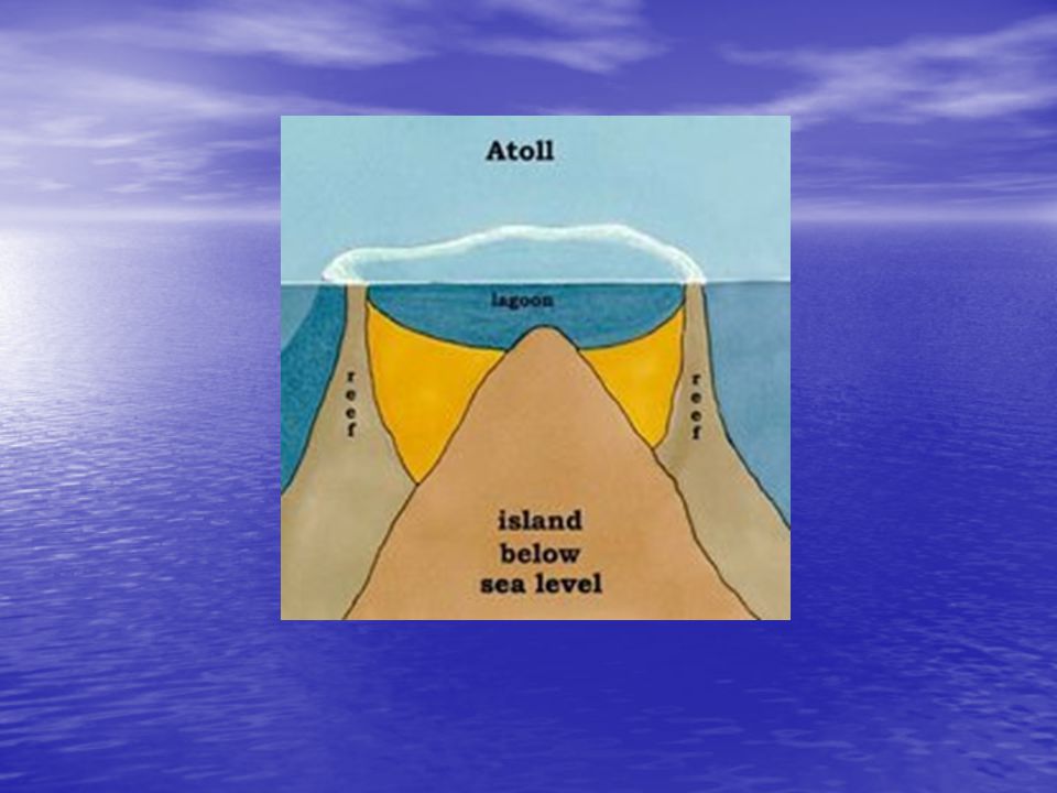


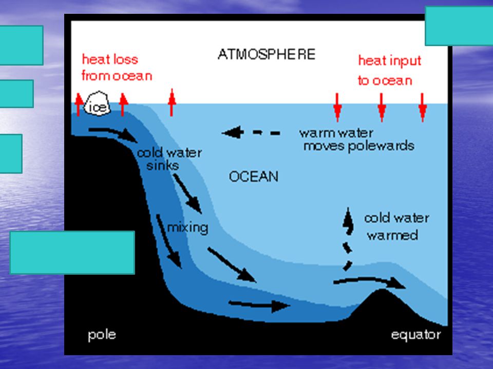
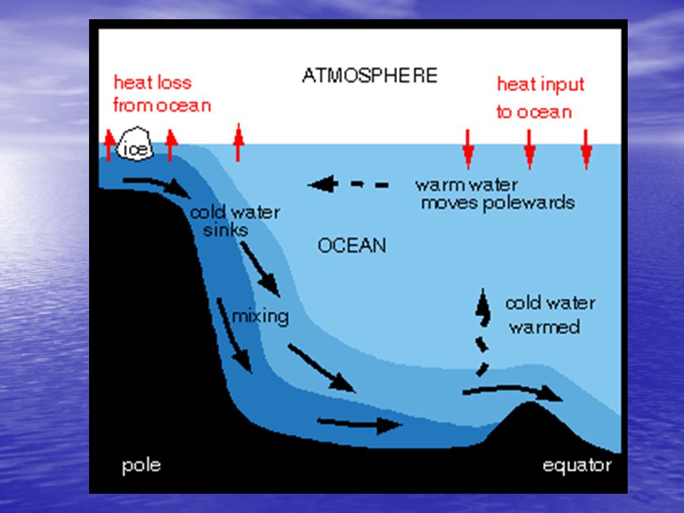


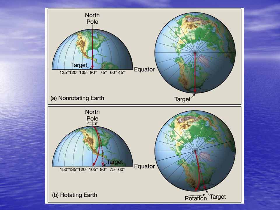


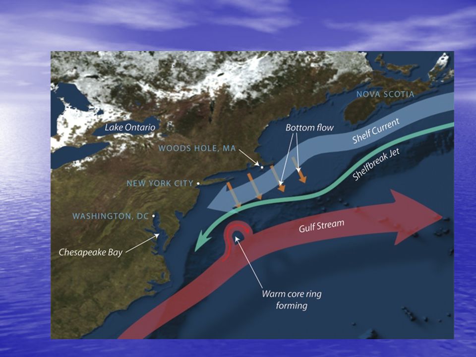


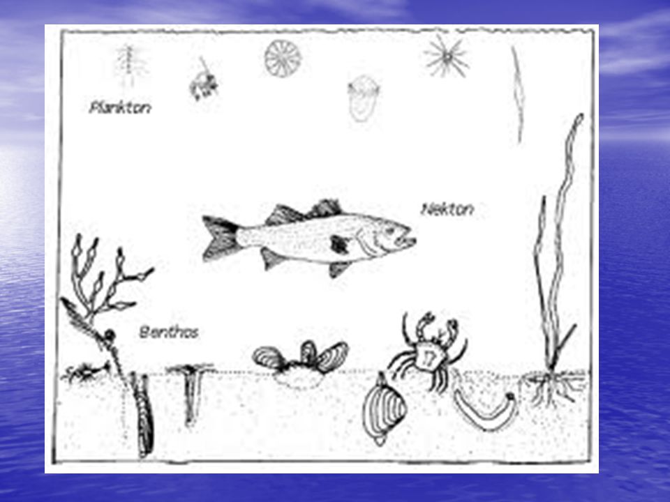
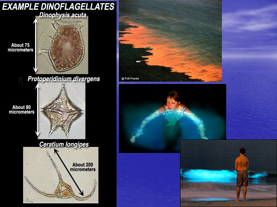
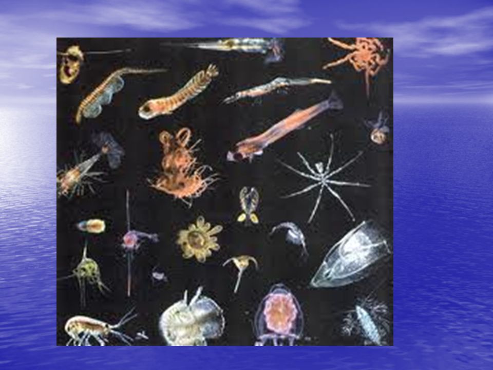


 plate boundary 2. Convergent (or destructive) plate.>")


