Download presentation
Presentation is loading. Please wait.

1
The Basics of Land Surveying & Land Development
Presented by Randal J. Vugteveen, P.S.

2
Firm Profile Nederveld was founded in 1977, specializing in Land Surveying. We have developed today into a multi-service organization providing comprehensive services in the following disciplines: Land Planning Community Architecture Civil Engineering Land Surveying High Definition Scanning Investigative Engineering.

3
Our Service Areas We service our clients across the country from four offices in Michigan. Grand Rapids, Michigan Ann Arbor, Michigan Hudsonville, Michigan Holland, Michigan Our projects have spanned from coast to coast in America, as well as into Canada, Mexico, & Costa Rica.

4
Agenda 1. The basics of Land Surveying 2. Land Divisions
May 7th, 2008 1. The basics of Land Surveying Different Types of Surveys Information needed 2. Land Divisions 3. The basics of Land Development Zoning What can I do with this land

5
History of Land Surveying in Michigan
George Washington Surveyor

6
History of Land Surveying in Michigan
Michigan Map c. 1600 Michigan Map c. 1805

7
History of Land Surveying in Michigan
Magnetic Compass Measuring Chains Solar Compass 1835

8
Town Range Established Baseline Meridian Controlled Surveying Towns
Ranges Town Range

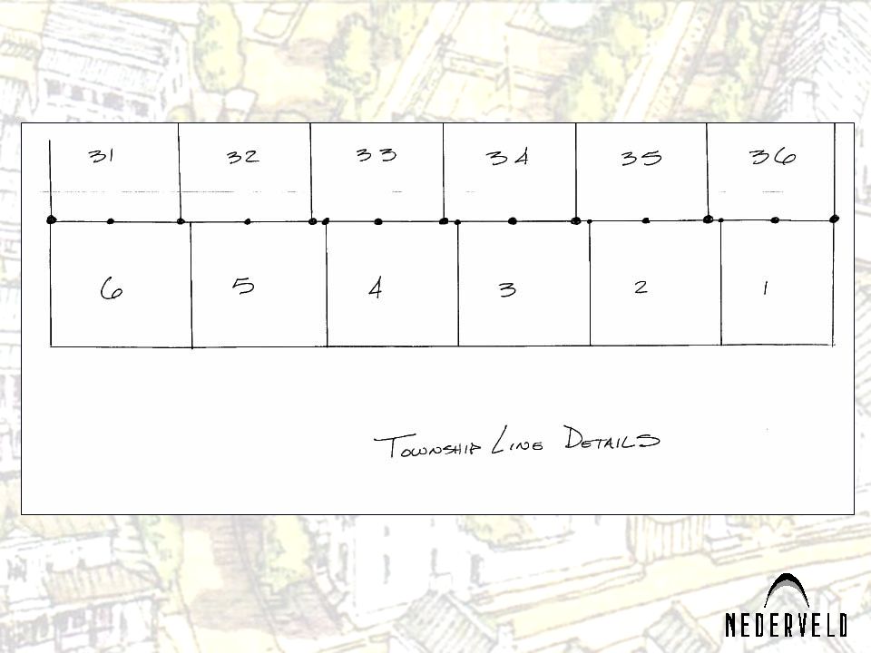
9
Town Range Detail of Town & Range T9N T8N T7N T6N T5N R16W R15W R14W

10
Laying out a Town and Range into Sections Example of a Township

11
One Section of Land 640 Acres
Northwest Corner North ¼ Corner Northeast Corner Center West ¼ Corner East ¼ Corner Southwest Corner South ¼ Corner Southeast Corner

20
The Town, Range and Section
establishes a base for the description of land Types of Land Descriptions Un-platted Land Aliquot Parts Metes and Bounds Platted Lands or Subdivisions

21
Un-platted Lands Aliquot Parts
Description: The West ½ of the Northwest ¼ of the Northeast ¼ of Section 36, Town 3 North, Range 16 West, Saugatuck Township, Allegan County, Michigan. Aliquot Parts

22
Un-platted Lands North Metes and Bounds West East South
North 00 Degrees West North 00 Degrees East North 90 Degrees West North 90 Degrees East West East South 90 Degrees West South 90 Degrees East South 00 Degrees West South 00 Degrees East South

23
Un-platted Lands Metes and Bounds
PARCEL 1 DESCRIPTION: Part of the Southwest 1/4 of Section 22, T7N, R16W, Grand Haven Township, Ottawa County, Michigan, described as: Beginning at the South 1/4 corner of said Section; thence S89°32'10"W feet along the South line of said Section; thence N01°47'43"W feet parallel with the North-South 1/4 line of said Section; thence N89°28'51"E feet along the North line of the South 1/2 of the Southwest 1/4 of said Section; thence S01°47'43"E feet along the North-South 1/4 line of said Section to the Point of Beginning. Subject to highway right-of-way for Lake Michigan Drive over the Southerly feet thereof. Also subject to easements, restrictions, and rights-of-way of record.

24
Platted Lands

25
How are we surveying today?
Backpack GPS GPS with an ATV Robotic Total Station

26
What type of survey do you need?
Mortgage Survey

27
What type of survey do you need?
Boundary Survey

28
What type of survey do you need?
ALTA Survey

29
What type of survey do you need? Elevation Certificate

30
What do we need from you to get a survey done?
Address Owners name Legal description / title commitment Parcel number Closing date / due diligence period / hopeful date

31
What do you want from us to make your job easier?
On-line order form? Fax order form? Call or direct?

32
Surveying is much more an art than a science.
Uncovering historic facts and researching past practices are keys to the art of surveying. Even with all the advances in technology, we often have to look to history for the answers to complex surveying challenges.

33
Land Division Land Division Act 288 of Amended under Act 591 of 1996 effective March 31, 1997 Land Division Keys: History of the Parcel Size of the Parcel (Exact) Zoning / Municipal Rules & Regulations LDA Guidelines 4:1 Ratio Accessible Adequate Easements for public utilities Less then one acre Exempt splits
 Zoning / Municipal Rules & Regulations. LDA Guidelines. 4:1 Ratio. Accessible. Adequate Easements for public utilities. Less then one acre. Exempt splits.")
34
Examples of Splits

35
Examples of Splits

36
The Basics of Land Development

37
Different Methods to Divide Land
Subdivision Land Division Condominium Act Commonly referred to as Site Condominium or Condominium

38
Regulations Affecting Development
State Subdivision Control MDEQ – Wetlands, Dunes, water supply, sewage disposal County Road Commission, Drain Commission, Health Department Zoning, Utilities Local City or Township Zoning, Roads, Streams, Wetlands, Water, Sewer, Buildings

39
Where do you Start? Local Level What is Zoning? Current Zoning
Master Plan Zoning What is Zoning? Most municipal zoning is use based zoning. Agricultural Residential 1, Residential 2 Commercial 1, Commercial 2 Industrial Zones have “Permitted” uses and uses by “Special Use”

40
ARTICLE 7. A AGRICULTURAL DISTRICT
Sec. 7.1 Description and purpose. This [A] zoning district is intended for large tracts of land used for farming or which are idle. It is not intended for any use except agricultural, very low-density, single-family residential use and other specialized rural uses requiring large tracts of land. Sec. 7.2 Permitted uses. Land, buildings or structures in this [A] zoning district may be used for the following purposes only: A. One-family dwellings. B. Farm buildings. C. Agriculture. D. Roadside stands. E. Agricultural research stations and activities. I. Home occupations when authorized as a special use by the planning commission pursuant to section 3.34 [of this ordinance]. J. Repair and maintenance services when operated in conjunction with a farming operation and when authorized as a special use by the planning commission. In considering such authorization, the planning commission shall consider the following standards: 1. The nature of the use; 2. The effect of the use on the surrounding neighborhood; 3. The environmental effects of the use; 4. The nature of the surrounding neighborhood; 5. Potential traffic congestion as a result of the use; and 6. Provision for parking for traffic or clientele which may result from the operation of the use.

41
ARTICLE 8. R-1 SINGLE-FAMILY RESIDENTIAL DISTRICT
Sec. 8.1 Description and purpose. This [R-1] zoning district is the most restrictive residential zone permitting one-family dwellings only together with required recreation, religious and educational facilities. Sec. 8.2 Permitted uses. Land, buildings or structures in this [R-1] zoning district may be used for the following purposes only: A. One-family dwellings. B. Churches, public schools and private and parochial schools which have been determined by the United States Internal Revenue Service to be an organization tax exempt under section 501(c)(3) of the Internal Revenue Code of 1954, as amended, or similar successor statute if: 1. The principal means of ingress and egress to the site is from a street classified as primary collector or major arterial in the township general development plan, as amended; 2. Fifty-foot side and rear yards are provided; and 3. No more than thirty-five (35) percent of the total land area of the lot or parcel of land is covered with buildings or structures. Before a building permit is issued for any building, structure or use authorized by this subsection, a site plan therefor shall be submitted for review and approval as provided in article 18A [of this ordinance]. ARTICLE 9. R-2 RESIDENTIAL DISTRICT Sec. 9.1 Description and purpose. This [R-2] zoning district is intended for one-family dwellings and two-family dwellings. Sec. 9.2 Permitted uses. Land, buildings or structures in this [R-2] zoning district may be used for the following purposes only: A. Any use permitted in the R-1 zoning district subject to the same conditions, restrictions and requirements as are provided in that zoning district. B. Two-family dwellings, provided that: (i) On or after December 31, 1989, each dwelling unit is provided with an attached private garage; (ii) The lot has frontage on a street classified as major arterial in the township general development plan; and (iii) The dwelling is aesthetically compatible in design and appearance with other dwellings in the vicinity. C. Home occupations when authorized as a special use by the planning commission pursuant to section 3.34 [of this ordinance].
(3) of the Internal Revenue Code of 1954, as amended, or similar successor statute if: 1. The principal means of ingress and egress to the site is from a street classified as primary collector or major arterial in the township general development plan, as amended; 2. Fifty-foot side and rear yards are provided; and. 3. No more than thirty-five (35) percent of the total land area of the lot or parcel of land is covered with buildings or structures. Before a building permit is issued for any building, structure or use authorized by this subsection, a site plan therefor shall be submitted for review and approval as provided in article 18A [of this ordinance]. ARTICLE 9. R-2 RESIDENTIAL DISTRICT. Sec. 9.1 Description and purpose. This [R-2] zoning district is intended for one-family dwellings and two-family dwellings. Sec. 9.2 Permitted uses. Land, buildings or structures in this [R-2] zoning district may be used for the following purposes only: A. Any use permitted in the R-1 zoning district subject to the same conditions, restrictions and requirements as are provided in that zoning district. B. Two-family dwellings, provided that: (i) On or after December 31, 1989, each dwelling unit is provided with an attached private garage; (ii) The lot has frontage on a street classified as major arterial in the township general development plan; and. (iii) The dwelling is aesthetically compatible in design and appearance with other dwellings in the vicinity. C. Home occupations when authorized as a special use by the planning commission pursuant to section 3.34 [of this ordinance].")
42
Municipalities will have different terms and requirements.
Common Question is: “What can I do with this property?” or “What is the minimum lot size?” What is it zoned? What is the master plan zoning? Is it possible to change the zoning? Now that we know our desired use is possible, what next?

43
Site Keys and Due Diligence
Site Terrain Public utilities or wells and septic systems Storm water runoff. Wetlands Soil Characteristics High Groundwater Existing Easements or title issues Environmental concerns Access to public roads Special ordinance requirements Etc.

44
I know my site is ready to develop, I just want a quick number of lots.
Every municipality views the number of possible lots differently. Close rule of thumb: Total site area 30 acres of useable land Desired zone minimum lot size 20,000 square feet 30 acres X 43,560sqft per acre = 1,306,800 square feet 1,306,800 X 80% = 1,045,440 square feet 1,045,440 square feet / 20,000 square feet per lot = 52.2 lots Roughly 80% of the site will be roads and drainage.

45
What is a PUD or Planned Unit Development?
Simply stated: A PUD is a form of Zoning This is an agreement in contractual form between the developer and the municipality to build a plan as negotiated between the two during a public meeting process.

46
Summary Zoning regulates what you can do.
Method you choose to record your project depends on other factors involved. Subdivision Land Division Condominium Act Commonly referred to as Site Condominium or Condominium Land Development is a Risk Hire the experts Perform adequate due diligence Know the market

Similar presentations