Download presentation
Presentation is loading. Please wait.

1
Cottonwood Wash Abandoned Mine Reclamation Project: A Partnership in Watershed Reclamation

2
Funding Federal Agencies: Interdepartmental Abandoned Mine Land Watershed Initiative Funds (Clean Water Action Plan) State: Surface Mining Control and Reclamation Act, Abandoned Mine Land Funds Total funds expended approx. $1.5 -BLM contribution $500,000, FS contribution $1M, state contribution $500,000. -FS contribution of $750,000 included stabilization of Cottonwood Road and construction of 17 hardened stream crossings. -State of Utah funds is through AML trust fund which is funded by a tax on current coal production and is received from the Office of Surface Mining (Dept. of Interior). -Clean Water Action Plan that supports aml reclamation can be found on page ___, and states “
. -Clean Water Action Plan that supports aml reclamation can be found on page ___, and states")
3
Clean Water Action Plan
Watershed Restoration National Program Described in the President’s Clean Water Action Plan of 1998 Funded by the Interdepartmental Abandoned Mine Land Watershed Initiative Purpose is for “Federal land managers to work in partnership with State and Local agencies, tribes, and private parties to develop strategies for the restoration of watersheds affected by abandoned mines.”

4
Agency Partners USDA Forest Service Bureau of Land Management
Utah Department of Natural Resources, Division of Oil, Gas and Mining, Abandoned Mine Reclamation Program Utah Department of Environmental Quality, Division of Water Quality -Forest Service partners included both the Regional Office (Intermountain Region), Manti-LaSal National Forest, and Monticello Ranger District office -Bureau of Land Management included Utah State Office, Moab, and Monticello Field Offices -Utah Division of Oil, Gas and Mining, Abandoned Mine Reclamation Program
, Manti-LaSal National Forest, and Monticello Ranger District office. -Bureau of Land Management included Utah State Office, Moab, and Monticello Field Offices. -Utah Division of Oil, Gas and Mining, Abandoned Mine Reclamation Program.")
5
Project Organization Steering Committee: Technical Committee:
Agency Directors Ensure project priority and availability of resources Provided dispute resolution Technical Committee: Resource Specialist and appropriate Decision Makers from each agency Conducted project level work -Resource specialists used on technical committee include EPA, line officers, and field office specialists -Steering Committee main guidance was that cooperation disregarded agency boundaries (including funding)
")
6
Agency Contributions BLM contributed AML inventory, exploration road inventory, water quality testing, biological assessment, project archaeologist and radiological studies FS contributed biological evaluation and waste dump characterization study State contributed contract procurement and administration, construction over-site, bat surveys, and assisted in AML inventory

7
Authorities Clean Water Act/Clean Water Action Plan
General Mining Law of 1872, as amended 43 CFR 3809 (BLM) 36 CFR 228 (FS) Organic Act (FS) Federal Land Policy Management Act (BLM) Surface Resources Act of 1955 Surface Mining Control and Reclamation Act of 1977 -
 36 CFR 228 (FS) Organic Act (FS) Federal Land Policy Management Act (BLM) Surface Resources Act of Surface Mining Control and Reclamation Act of")
8
Site Selection: Why Cottonwood Wash?
Mixed ownership: BLM, FS, State Water State priority watershed Mining impacts -Gross alpha particles at levels that exceed State’s water quality standards) and listed on the State’s (d) list of non-supporting waters -From earlier inventory, recognized that there was a high density of mines on both FS and BLM land. -Used criteria to access public/NFS lands that had aml features that created water quality problems (such as density of features, proximity to stream, presence of physical safety hazards, recreational use, other human health hazards, and ability to implement)
 and listed on the State’s (d) list of non-supporting waters. -From earlier inventory, recognized that there was a high density of mines on both FS and BLM land. -Used criteria to access public/NFS lands that had aml features that created water quality problems (such as density of features, proximity to stream, presence of physical safety hazards, recreational use, other human health hazards, and ability to implement)")
9
Cottonwood Wash Background
Description of the watershed - 143,000 acres, ranging from 4,500 feet to 9,500 feet in elevation BLM lands comprise 33%; USDA-FS, 60%; State, 4%; Tribal, 3%. Mined for nearly 9 decades for vanadium and uranium Water sampling showed elevated gross alpha radiation -the watershed is located in the lower San Juan-Four Corners, and the wash flows into the San Juan River. -Project area is lands in the drainage, north of State Highway 95. -Located along and to the east of Elk Ridge, and south/southwest of the Abajo Mtns. -The tribal portions is private property held in allotment by the Ute Mountain Ute tribe. --Poor water quality limits beneficial uses for drinking, recreation, aquatic life, wildlife, grazing, and agriculture

10
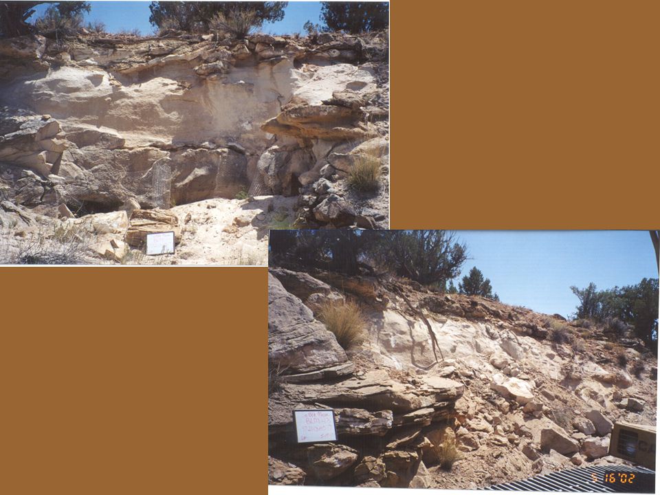
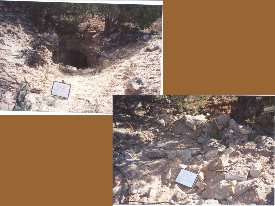
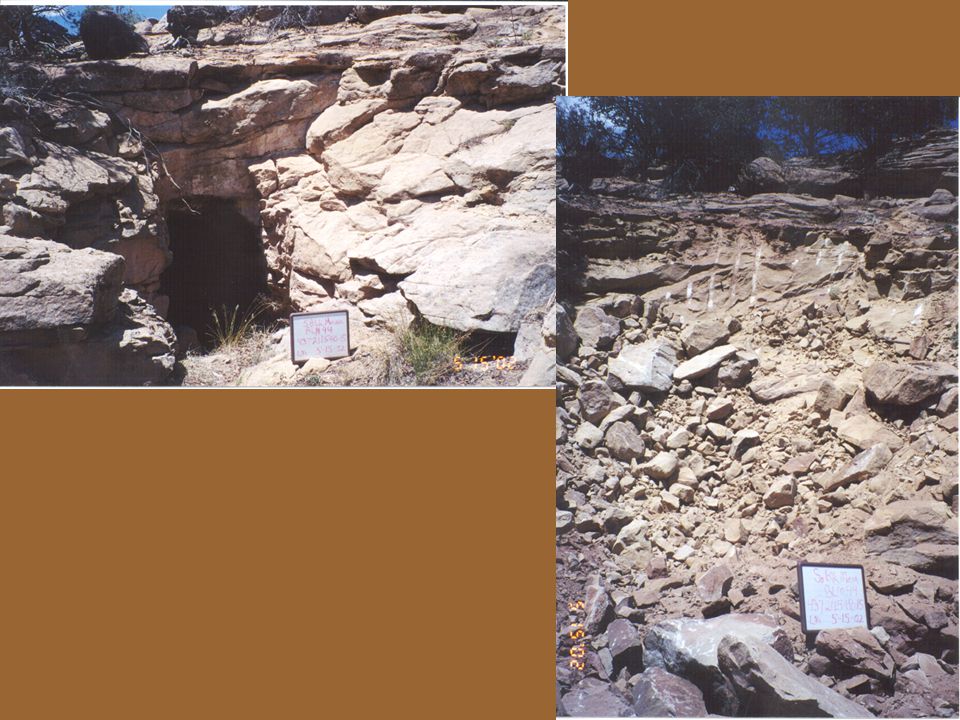
What Are The Problems? Dangerous mine openings Radon
Mined waste dumps/piles contributing sediment and uranium to the stream Exploration roads contributing sediment -Open mines are dangerous: roofs may cave in and walls may collapse; internal timber supports may fail; drops to lower levels of the mine may be obstructed or unseen; oxygen may be at dangerously low levels; and radiation exposure is a concern. -Roads are sources of sediment runoff, pose a threat to water quality, and may remove lands from beneficial resource production. Drill holes located on or near these road ways need to be plugged because they pose a threat to physical safety and are a pathway for pollutants to enter ground water. -The CW road, including associated stream crossings, requires stabilization to reduce sediment runoff to streams, minimize dust, and limit further degradation of water and air quality.

11
What Are The Solutions? Close mines that present a risk to human health and welfare Stabilize mine waste dumps that are eroding into the streams and affecting water quality Reclaim unneeded access roads, mineral exploration roads and trails Stabilize the primary road in Cottonwood Wash

12
What Are The Reclamation Goals?
Close the mine openings to protect the public from radon emissions and accidents Remove and/or reclaim waste piles and roads Plug drill holes Seed disturbed areas with native vegetation to create habitat and reduce erosion

13
Project Approach Needed Studies/Surveys
AML inventories Water quality studies Radiological surveys EPA and Oakridge National Laboratory Bat surveys Cultural resource inventories Exploration road surveys Biological assessments and evaluations -Mine features,exploration road surveys, biological assessment, and water quality study design were conducted by BLM -Water quality studies, bat surveys, abandoned mine inventory/radiological surveys conducted by State -Biological evaluation conducted by FS -Radiological evaluation conducted by EPA

14
Preparation Plan for the Environmental Assessment
Writing Proposed Action Identifying the purpose and need Conformance with Land Use Plans Scope of the EA (i.e. alternatives) Scoping and public involvement Authorizing decisions
 Scoping and public involvement. Authorizing decisions.")
15
Preparation Plan for the Environmental Assessment Continued
Strategy for preparation and contracting of the EA Contractor selection process Contract Administration Data and information needs Statement of work The statement of work identified what field work would be conducted, how the analysis should be conducted for each alternative, the need for monthly progress reports from the contractor, monthly coordination meetings between all parties, consultation documents (section 106 National Historic Preservation Act and section 7 Threatened and Endanger Act), EA publication standards and deliverables and performance measures.
, EA publication standards and deliverables and performance measures.")
16
Environmental Analysis
Scoping Internal External (Public Meetings) Environmental Analysis (written by 3rd party contractor) Decision Record/FONSI (BLM) Decision Notice/FONSI (FS) FONSI – DOGM (Office of Surface Mining) -Internal scoping was conducted at BLM and FS local field offices (lengthy list of resource staff specialists) -External scoping involved a public meeting to identify issues prior to preparing EA, and a follow-up public meeting to introduce the EA and solicit comments -Decision Record/Decision Notice and Finding of No Significant Impacts -Overcame many differences on divergent regulations on NEPA (FS most stringent so that pervailed) -Decision Record clarified mitigating measures and outstanding issues before the decision could be implemented
 Environmental Analysis (written by 3rd party contractor) Decision Record/FONSI (BLM) Decision Notice/FONSI (FS) FONSI – DOGM (Office of Surface Mining) -Internal scoping was conducted at BLM and FS local field offices (lengthy list of resource staff specialists) -External scoping involved a public meeting to identify issues prior to preparing EA, and a follow-up public meeting to introduce the EA and solicit comments. -Decision Record/Decision Notice and Finding of No Significant Impacts. -Overcame many differences on divergent regulations on NEPA (FS most stringent so that pervailed) -Decision Record clarified mitigating measures and outstanding issues before the decision could be implemented.")
17
Cottonwood Wash Total Maximum Daily Load (TMDL)
Elevated levels of gross alpha radiation in surface water Source identification and assessment Discusses pollutant loading and required load reduction Control and Best Management Strategies Monitoring plan

18
T & E Species Section 7 Consultation

19
Cultural Resources Full-time project archaeologist
106 Compliance through Programmatic Agreement involving 7 signatories, addressed the following: Prehistoric Cultural Resources Discovery Plan Eligibility Treatment NAGPRA Historic Mining Resources Interpretative Plan Research Avoidance Preservation Mitigation -Signatories of Participating Agreement included agencies, tribes, ????? -BLM hired a full-time project archaeologist to address complicated cultural resource issues and tribal consultation

20
Key Points of the Decision Record
A Ute Mountain Ute right-of-way required before construction of hardened stream crossings 1-11 and graveling of the Cottonwood Wash Road. Abandoned mine sites will be reclaimed even if the State AMRP cannot obtain a right-of-entry. Reclamation will not endanger or materially interfere with prospecting, mining, or processing operations or uses reasonably incident thereto. Construction work will not proceed until programmatic Agreement filed with Advisory Council on Historic Preservation

21
Key Points of the Decision Record continued
Certificate of Registration required for appropriate State personnel A vegetation avoidance strategy-penalty payment by the contractor for unnecessary disturbances. A monitoring plan would be developed and implemented upon completion of reclamation Construction activities will be monitored by the UDOGM, AMRP Construction noise and activity timed to reduce impacts on wildlife

22
Construction Reclamation Groups (geographical)
Reclamation Phases (sequencing) Specifications: written by DOGM with modifications from partners Project archaeologist played major role in design development to avoid adverse impacts DOGM issued construction contract and provided management and oversight -First phase began in September of 2001; two more completed by end of calender year (December 31st f 2001); next four phases in 2002 with completion of mine reclamation anticipated by end of 2002. -Road reclamation may extend into 2003. -Issuance of construction contracts and oversight of implementation conducted by DOGM
 Specifications: written by DOGM with modifications from partners. Project archaeologist played major role in design development to avoid adverse impacts. DOGM issued construction contract and provided management and oversight. -First phase began in September of 2001; two more completed by end of calender year (December 31st f 2001); next four phases in 2002 with completion of mine reclamation anticipated by end of Road reclamation may extend into Issuance of construction contracts and oversight of implementation conducted by DOGM.")
23
Products Compact Disc with all relevant GIS layers for all partners
Preparation Plan EA TMDL Analysis Cultural Survey Report Radiological Interpretation Report of waste dumps, water, openings, and millsite

24
Products and Milestones (continued)
Radiological interpretation of water quality data Bat survey report 3 issues of Blue Mountain Shadows (publication of San Juan County Historical Commission): Mining History of Cottonwood Wash Pre-history of Cottonwood Wash Specifications for reclamation construction Utah Geologic Assoc. newsletter
: Mining History of Cottonwood Wash. Pre-history of Cottonwood Wash. Specifications for reclamation construction. Utah Geologic Assoc. newsletter.")
25
Media Coverage Salt Lake Tribune San Juan County Record (Monticello)
Times Independent (Moab) Radio and TV news coverage
 Radio and TV news coverage.")
26
Unique Challenges Cultural Resources (pre-pueblo ruins)
Active mining claimants and rights-of-entry Historic mining districts Wildlife (survey and construction guidelines) Land ownership
 Land ownership.")
27
Unique Challenges (continued)
Determining appropriate players (representative from each organization and organizational level appropriate for your project) Communication and Agency Culture Decision making
 Communication and Agency Culture. Decision making.")
28
On the Ground Results North Black Mesa Butte South Black Mesa Butte
6 BLM sites South Black Mesa Butte 10 BLM sites East Black Mesa Butte 5 BLM sites

37
Remaining Segments West Black Mesa Butte Mancos Jim Butte
36 BLM sites Mancos Jim Butte 3 FS sites and 2 BLM sites Poison Canyon 9 FS sites Chippean Rocks 7 FS sites

Similar presentations


 896-5111.>")
>")


 information in a variety of ways.>")

