Download presentation
Presentation is loading. Please wait.

1
TOPOGRAPHIC MAP NOTES

2
TOPOGRAPHIC MAP NOTES Directions: 1. List group member names in a text box on title page. 2. Copy notes onto handout to be glued into journal. 3. On slides with questions, type answers to questions into the “NOTES” box at the bottom of the slide in “edit view”. Vocabulary to focus on: a. Contour lines e. Hachures b. Steep slope f. V c. Gradual slope g. Contour interval d. Sea level h. Index contour 4. Answer the questions needing to be answered in the Notes box in “edit” mode

5
#2 Topographic maps are useful because they represent the three-dimensional image of the land by using lines and symbols.

6
Topographic maps show the location and shape of mountains, valleys, plains, streams, wooded areas, roads, buildings, and many other features.

7
Topographic maps are graphic representations of the surface of the Earth.
They provide: a plan (bird's-eye) view of the land scales to measure ground distances bearings to indicate directions coordinate systems to locate features symbols for natural and cultural features contour lines to show the elevation, slope, and relief of the landscape
 view of the land. scales to measure ground distances. bearings to indicate directions. coordinate systems to locate features. symbols for natural and cultural features. contour lines to show the elevation, slope, and relief of the landscape.")
8
Topographic maps are useful tools for planning highways, recreation areas, airports, housing developments, etc. For you, topographic maps may be useful for recreational activities such as hiking, boating, camping, fishing or hunting. How could you use a topographic map when camping?

9
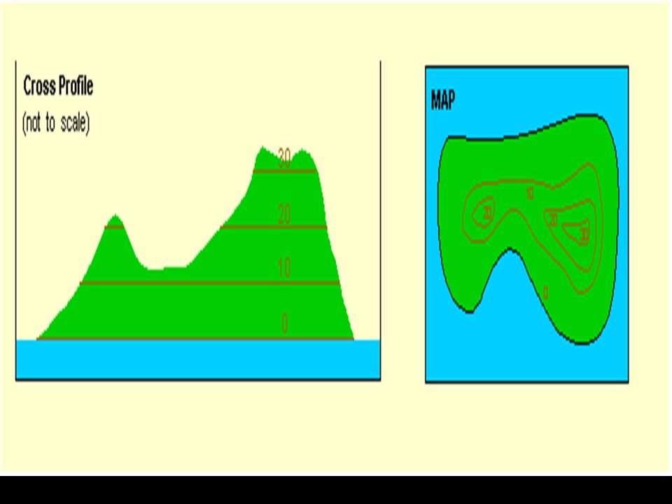
What is Topography? Topography is the configuration of the land surface, and it is shown on topographic maps with contour lines. Map of Valleys Map of Hills

10
TOPOGRAPHIC MAP NOTES CONTOUR LINES lines on your map that show
#9 TOPOGRAPHIC MAP NOTES CONTOUR LINES lines on your map that show a change in elevation .

11
Trace the lines of your layers of the skewer boldly.

12
Contour Line W1 W2 W3 W4 E1 E4 E3 E2 0m Sea Level

13
Contour Line W1 W2 W3 W4 E1 E4 E3 E2 4m 0m Sea Level

14
Contour Line W1 W2 W3 W4 E1 E4 E3 E2 8m 4m 0m Sea Level

15
Contour Line W1 W2 W3 W4 E1 E4 E3 E2 12m 8m 4m 0m Sea Level

16
Steep Slope (higher) W2 W3 W1 W4 E4 E3 E2 E1 Gradual Slope (lower)
 W2 W3 W1 W4 E4 E3 E2 E1 Gradual Slope (lower)")
17
Rules of a Contour line Each contour line represents one elevation.
All contour lines eventually connect with themselves. Contour lines never cross each other. Contour lines never split or branch.

18
Rules of a Contour line 5. Contour interval: the vertical spacing
(the difference in elevation) between 2 side by side countour lines. 6. Index Contour: Every 5th contour is printed darker called index contours dark lines marked with elevations (key).
 between 2. side by side countour. lines. 6. Index Contour: Every 5th contour is printed darker called index contours. dark lines marked. with elevations (key).")
19
Rules of a Contour line V Hachures are
short lines used to show a depression. 8. Contour lines that form V’s point upstream whenever they cross streams.

20
Points on the map marked "BM" are called Bench Marks.
#14 Points on the map marked "BM" are called Bench Marks. Bench marks are survey points of known elevation. The exact elevation of a point is given as "BM 60" (for an elevation 60 feet above sea level). Closely spaced contour lines represent steep slopes. Widely spaced contour lines represent gentle slopes.
. Closely spaced contour lines represent steep slopes. Widely spaced contour lines represent gentle slopes.")
21
#16 Remember that streams and rivers flow downhill (from higher elevations to lower elevations). The point of the "V" points uphill or upstream. (Look at map and think about this for a minute.) Note that where a contour line crosses a stream or river (or even a dry gully or valley), the contour lines are bent sharply, forming a "V".
 Note that where a contour line crosses a stream or river (or even a dry gully or valley), the contour lines are bent sharply, forming a V .")
22
Hachures

23
Closed depressions, such as lakes or canyons, are indicated by contour lines that form roughly a circle, with short "tick marks" or "hachure marks" perpendicular to them on the downhill side. A series of concentric contour lines in a rough circle represents a hill.

24
Which rule was broken?

25
A.

26
B.

27
C.

28
D.

29
Sea-Level (where water meets the land) = 0 m
 = 0 m")
30
What if they don’t give you the contour interval?
THAT’S EASY TOO…. Big # - little # # of lines

31
What is the contour interval?
100 5 800 700 Big # - little # # of lines 5 20 m =

32
List the elevation for: E: ___ F: ___ G: ___ H:____

33
If this is an island… what is the elevation of point I?

34
J. Contour Interval = ?

35
Your turn! 20 K.

36
Your turn! L.

37
Contour Line Rules (cont.)
Closely spaced contour lines represent steep slopes. Widely spaced contour lines represent gentle slopes.

39
List the elevations for A: ____ B: ____ C: ____ D: ____ E: ___

40
Formative Assessment List the elevations for
A: ____ B: ____ C: ____ D: ____ E: ___

41
An Elevated View In the table on the back of this sheet draw a
topographic map illustrating the following landforms in the BEFORE column: A tall mountain (steep) A flat island A deep canyon (a depression or hole)
 A flat island. A deep canyon (a depression or hole)")
42
An Elevated View a. the tall mountain is affected by run-off from
2. Draw a topographic map in the AFTER column, predicting what each landform will look like after: a. the tall mountain is affected by run-off from melting snow caps (snow covering a mountain peak). b. the flat island is eroded (the movement of sediment from one location to another) by ocean waves. c. the deep canyon is eroded by a swift (fast)-flowing river.
. b. the flat island is eroded (the movement of. sediment from one location to another) by. ocean waves. c. the deep canyon is eroded by a swift (fast)-flowing river.")
43
Landform Before After A tall mountain (Steep) A flat island
A deep canyon (depression or hole)
")
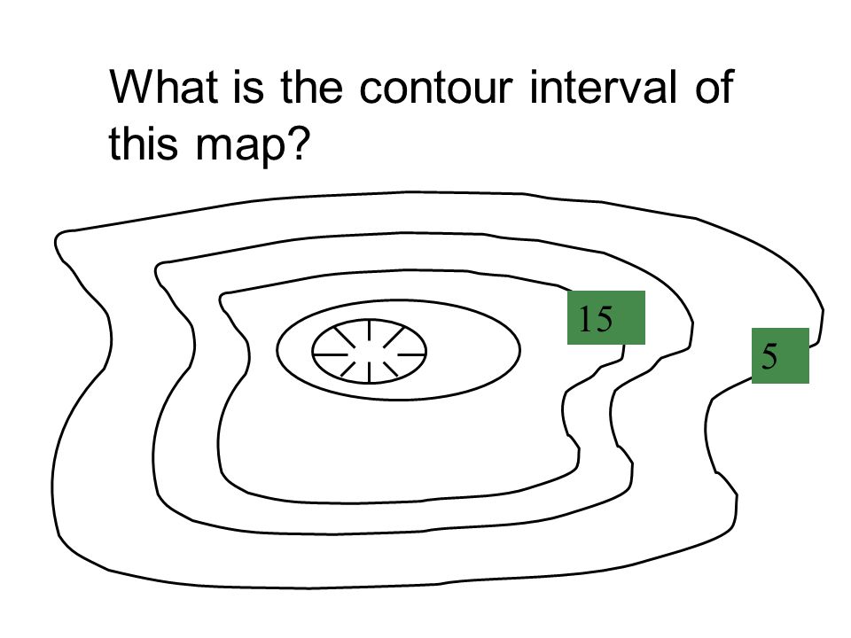
44
What is the contour interval of this map?
15 5
45
What is the contour interval of this map?
2 8

46
Topographic Map Assessment

47
Assessment Word Bank 100 feet 25 feet Hills or depressions elevation
Upstream Never Index contours difference in elevation between two side-by-side contour lines. equal elevation 30 feet 100 feet

48
What is the contour interval of this map?
1. What is the contour interval of this map? 25 100

49
What is the contour interval of this map?
2. What is the contour interval of this map? 90

50
3. Contour lines _________ cross?

51
_____ _______are marked with the elevation.
4.

52
Contour lines close around _____ or __________.
5.

53
Contour lines form V’s that point _________ whenever they cross streams.
6.

54
_____________________
The contour interval is the _____________________ _____________________ 7.

55
A contour line is a line on a map that connects points of _______ _______.
8.

56
Topographic maps show the changes in _________of the Earth’s surface.
9.

57
What is the highest elevation on this map?
10. What is the highest elevation on this map? 75 25

58
Directions: Write your name, date, and period #.
Read this passage on mapping erosion control. Write the main idea for each paragraph on the left side of each paragraph. Answer the reading comprehension questions at the end of the passage.

59
Topography Tic-Tac-Toe Vocabulary
Contour lines Hachures Steep slope V Gradual slope Contour interval Sea level Index contour Peak Class Set

60
Topography Tic-Tac-Toe Vocabulary
Contour lines Hachures Steep slope V Gradual slope Contour interval Sea level Index contour Peak Class Set

Similar presentations


 of the Earth’s surface.>")


