Download presentation
Presentation is loading. Please wait.

1
The Southern Ocean Observing System (SOOS)
With additional support from

2
Talk Outline Why are coherent, sustained observations of the Southern Ocean needed? Who would use them? What aspects of the Southern Ocean would a monitoring system address, and how? What is already in place, and what are the gaps? Where are we in relation to planning and implementing the observing system, and what is next? How would a SOOS link to other international efforts?

3
Talk Outline Why are coherent, sustained observations of the Southern Ocean needed? Who would use them? What aspects of the Southern Ocean would a monitoring system address, and how? What is already in place, and what are the gaps? Where are we in relation to planning and implementing the observing system, and what is next? How would a SOOS link to other international efforts?

4
Global reach of the Southern Ocean
Reasons for a SOOS - Lumpkin and Speer (2006) Critical part of the global thermohaline circulation
 Critical part of the global thermohaline circulation.")
5
Change in zonally-integrated ocean heat content
since 1955 is largest in the southern oceans Levitus et al., 2005 Important term in global heat budget, but Southern Ocean is still undersampled compared with rest of World Ocean

6
Boening et al., 2008

7
Warming in ACC, no change in overturning?
Comparison of Argo + CTD data along streamlines shows warming across the Southern Ocean, strongest on southern flank of ACC. Southward shift of isopycnals BUT little change in tilt, hence no change in upwelling (unlike in IPCC models). Boening et al., 2008 7
. Boening et al.,")
8
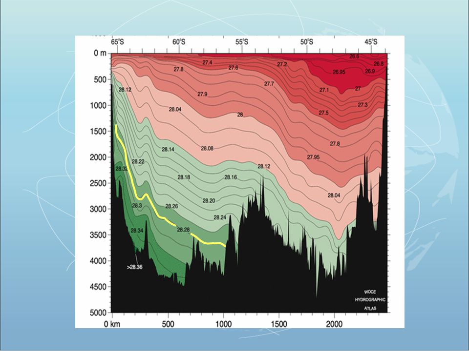
Freshening of AABW 8

10
The Weddell gyre circulation and the area of observations carried out during WECCON and CASO
Fahrbach, AWI

11
Area of WSBW on the transect decreased by 25%
from 1992 to 2008 1992 2008 Fahrbach, AWI

12
Bottom melting: heat source and effect of pressure.
Mode 1: Thermohaline circulation induced by sea ice formation and drainage of dense saline water. Melting point decreases as much as 1oC due to oC/dbar-1 Mode 2: Direct inflow of intermediate-depth ‘warm’ water from the slope-front region (e.g. Circumpolar Deep Water intrusion through deep troughs). Mode 3: Ice-front interactions (tidal pumping, coastal currents) AASW CDW ISW Jacobs et al., 1992 Ice shelf water may refreeze to form marine ice, or sink to participate in the formation of Antarctic bottom water, which regulates global climate. Mode 1 dominates for large ice shelves in the Weddell, and Ross seas. Mode 2 melts large volumes of ice where deep water has access to glacier grounding lines, e.g. Amundsen Sea.
. Mode 3: Ice-front interactions (tidal pumping, coastal currents) AASW. CDW. ISW. Jacobs et al., Ice shelf water may refreeze to form marine ice, or sink to participate in the formation of Antarctic bottom water, which regulates global climate. Mode 1 dominates for large ice shelves in the Weddell, and Ross seas. Mode 2 melts large volumes of ice where deep water has access to glacier grounding lines, e.g. Amundsen Sea.")
13
Conclusions Ice shelf melting controls > 50% of the ice sheet/ice shelf mass balance. This neglects ice-front sub-aqueous melting. Low melt on large ice shelves (far from CDW), Queen Maud Land, East Peninsula. High melt on West Peninsula (CDW), Amundsen, Bellingshausen sea (CDW), Wilkes Land (?). Quadratic dependence on temperature where CDW fuels high melt. Elsewhere, linear relationship might still hold but not enough ocean temperature data near GL.
, Queen Maud Land, East Peninsula. High melt on West Peninsula (CDW), Amundsen, Bellingshausen sea (CDW), Wilkes Land ( ). Quadratic dependence on temperature where CDW fuels high melt. Elsewhere, linear relationship might still hold but not enough ocean temperature data near GL.")
14
Antarctica loss increased from -112 to -196 Gt/yr
EAIS 61 Gt/yr WAIS 59 Gt/yr WAIS 60 Gt/yr WAIS 50 Gt/yr AP 45 Gt/yr AP 46Gt/yr Antarctica loss increased from -112 to -196 Gt/yr

16
Ocean uptake of carbon dioxide
Sabine et al., 2004 Southern Ocean a key region for uptake of anthropogenic CO2 – but is the carbon sink weakening (Le Quéré etc)?
")
17
Le Quere et al., 2007

18
Why a SOOS (continued…) ?
Krill stocks in key parts of the Southern Ocean are in steep decline… need to understand why, and the implications. (Atkinson et al., Nature, 2004)
")
19
Why a SOOS (continued…) ?
Changes in Southern Ocean temperature and circulation could have strong impacts on West Antarctic ice sheet (and hence global sea level) Nutrients exported from the Southern Ocean support 75% of oceanic primary production north of 30S (Sarmiento et al.) The Southern Ocean includes some of the most productive and unique marine ecosystems on Earth etc…
 Nutrients exported from the Southern Ocean support 75% of oceanic primary production north of 30S (Sarmiento et al.) The Southern Ocean includes some of the most productive and unique marine ecosystems on Earth. etc…")
20
Why do we care if SO changes?
Potential for positive feedbacks influencing global climate Sea ice – albedo Carbon uptake Thermohaline circulation Sea-level rise Impact of acidification on ecosystems Impact of climate change on ecosystems (warming, freshening, mixed layer, light, circulation, sea ice, winds)
")
21
Talk Outline Why are coherent, sustained observations of the Southern Ocean needed? Who would use them? What aspects of the Southern Ocean would a monitoring system address, and how? What is already in place, and what are the gaps? Where are we in relation to planning and implementing the observing system, and what is next? How would a SOOS link to other international efforts?

22
Potential users of a SOOS include …
Research community Resource managers (including CCAMLR etc) Policy makers (when is it time to act? What are the consequences of not acting?) IPCC Local planners (sea-level rise) Antarctic tourism Shipping operations Weather and climate forecasters Education Etc.
 Policy makers (when is it time to act What are the consequences of not acting ) IPCC. Local planners (sea-level rise) Antarctic tourism. Shipping operations. Weather and climate forecasters. Education. Etc.")
23
Talk Outline Why are coherent, sustained observations of the Southern Ocean needed? Who would use them? What aspects of the Southern Ocean would a monitoring system address, and how? What is already in place, and what are the gaps? Where are we in relation to planning and implementing the observing system, and what is next? How would a SOOS link to other international efforts?

24
Scope of the SOOS Space: circumpolar
Subtropical Front to coast / ice shelf grounding line Time: days to decades (longer-term proxies from ice and sediment cores are critical, but lie outside of SOOS) Domain: sea surface to sea floor (including bathymetry) ocean + sea ice include air-sea flux, not upper atmosphere include sub-ice shelf cavity, not glacial ice itself Feasibility/readiness: consider READY NOW, 5-10 YEAR VISION and BY 2030 consider both MINIMAL and IDEAL
 Domain: sea surface to sea floor (including bathymetry) ocean + sea ice. include air-sea flux, not upper atmosphere. include sub-ice shelf cavity, not glacial ice itself. Feasibility/readiness: consider READY NOW, 5-10 YEAR VISION and BY consider both MINIMAL and IDEAL.")
25
Scope of the SOOS Discipline: physics (ocean circulation and sea ice)
biology and ecology (microbes to whales...) biogeochemistry bathymetry surface meteorology Models: Emphasis is on sustained observations, but modelling plays a key role in system design interpolation and interpretation of sparse observations demonstrating utility of SOOS (eg initialisation of climate models)
 biogeochemistry. bathymetry. surface meteorology. Models: Emphasis is on sustained observations, but modelling plays a key role in. system design. interpolation and interpretation of sparse observations. demonstrating utility of SOOS (eg initialisation of climate models)")
26
Talk Outline Why are coherent, sustained observations of the Southern Ocean needed? Who would use them? What aspects of the Southern Ocean would a monitoring system address, and how? What is already in place, and what are the gaps? Where are we in relation to planning and implementing the observing system, and what is next? How would a SOOS link to other international efforts?

27
Some examples of observing system elements already in place…

28
Hydrography CTD/XBT/CO2 5-10 yr interval
Hydrography still the mainstay

29
Argo http://argo.ocean.fsu.edu/
Note should use most up to date version of this figure (site is down today )
")
30
Sound sources deployed in Weddell Sea to track modified Argo floats under ice
Ensonification of certain areas (e.g. Weddell Sea) allows under ice tracking of floats
 allows under ice tracking of floats.")
31
Temperature and current field in the area of Maud Rise derived from floats – Olaf Klatt
Geschwindigkeit und Temperatur in 800m Tiefe. geglättet

32
Tagging of marine mammals (SEaOS etc)
These guys are also very helpful…

33
Elephant seal oceanography
Mapping the ocean underneath the sea ice for the first time (Charassin et al., PNAS, 2008).
.")
34
SEaOS: Number of profiles
SODB: 10513 Argo: 19463 SEaOS: 22230 SEaOS especially useful as can obtain data under ice. Accuracy of T now around C Courtesy L. Boehme

35
Mapping high latitude fronts

36
Sea ice formation from salinity change
Charassin et al., PNAS, 2008

37
Near circumpolar coverage from elephant seal data …
Use of seals…Large increase in data, especially under ice! Important for both ecosystems and physics… Other species can be targeted to access specific icy regions. Invaluable data for both ecological and physical sciences.

38
Continuous Plankton Recorder Tows 1991-2008
The Survey covers >70 % of the Southern Ocean October to April Approximately tows each year >4,000 samples p.a. 5 n-mile resolution 135,000 nautical miles of data have been collected since 1991 This represents more than 27,000 samples, 200+ taxa +environmental data SCAR CPR study – Zooplankton observing system Australia, Japan, NZ, Germany, UK, USA, Russia Hosie et al

39
What observing system elements are already in place?
Above plus:- Satellites (e.g. SeaWiFS, Cryosat) Current meter arrays Tide gauge network Sediment trap moorings Underway measurements (e.g. CO2 , Salinity…) Sea ice thickness; snow cover; drift Etc…. What observing system elements are already in place? Many different observations in place, but many gaps and could be more coordination between disciplines…
 Current meter arrays. Tide gauge network. Sediment trap moorings. Underway measurements (e.g. CO2 , Salinity…) Sea ice thickness; snow cover; drift. Etc…. What observing system elements are already in place Many different observations in place, but many gaps and could be more coordination between disciplines…")
40
Gaps in the observing system in the
Southern Ocean region Ice-covered regions still poorly sampled, despite progress Deep ocean below depth of Argo Ocean in ice shelf cavities Seabed is poorly observed (benthic communities etc) Non-physical measurements rarely routinely made (need other sensors for Argo etc) etc
 Non-physical measurements rarely routinely made (need other sensors for Argo etc) etc.")
41
Gaps in the observing system in the Southern Ocean region
Routine measurements beneath the ice shelves required to understand how the ocean/ice-shelf interaction will change as the climate alters, and what the impacts may be for deep and bottom water formation and the global overturning in the ocean Development of new sensors and methodologies is key (e.g. biogeochemistry sensors to Argo floats, automated under-ice measuring systems, technology to study the long-term impact of seasonal ice cover on pelagic and benthic communities) This is not least because it is thought that a steadily warming ocean may degrade ice shelves and glacier snouts from beneath, thinning them so that they break up as did the Larsen ice shelf in 2002.The break-up of such ice shelves removes the dam that slows glacier discharge from the interior, thus having an effect on how rapidly inland ice can drain to the sea and raise sealevel
 This is not least because it is thought that a steadily warming ocean may degrade ice shelves and glacier snouts from beneath, thinning them so that they break up as did the Larsen ice shelf in 2002.The break-up of such ice shelves removes the dam that slows glacier discharge from the interior, thus having an effect on how rapidly inland ice can drain to the sea and raise sealevel.")
42
Gaps in the observing system in the Southern Ocean region
Need to sample the polar oceans routinely and cost-effectively with an appropriate level of coverage to capture the main oceanographic, meteorological, cryospheric and ecosystems processes taking place there that contribute to global change

43
Talk Outline Why are coherent, sustained observations of the Southern Ocean needed? Who would use them? What aspects of the Southern Ocean would a monitoring system address, and how? What is already in place, and what are the gaps? Where are we in relation to planning and implementing the observing system, and what is next? How would a SOOS link to other international efforts?

44
SOOS Timeline August 2006: Initial scoping workshop, Hobart
October 2007: Workshop in Bremen. Planning and writing tasks assigned July 2008: St. Petersburg progress review meeting January 2009: Make draft SOOS planning document available to community for comment February 2009: Comments received March 2009: Publish report April 2009: Commence implementation...

45
SOOS Structure SOOS planning document (to go out to the community for comment) will outline the aspects discussed here:- why sustained observations are needed in the Southern Ocean and what science/policy questions they address, what mix of observations are required to address these questions, what is presently done and what is possible, a vision for the future (in 5-10 years; and by 2030)
")
46
SOOS designed to address six key challenges
Role of Southern Ocean in global freshwater balance Stability of Southern Ocean overturning Stability of Antarctic ice sheet and future contribution to sea-level rise Future of Southern Ocean carbon uptake Future of Antarctic sea ice Impacts of climate change on Antarctic ecosystems Guided by Science….

47
In report we will use a two layer table system – firstly identify what variables we need to measure…(table still draft) (*draft*)
")
48
Then what platforms are required to measure variables (note table is still draft)
")
49
Strawman Southern Ocean Observing System
Initial SOOS consists of coordination/enhancement of extant elements, as discussed, including:- Repeat full-depth hydro/tracer sections along WOCE lines Profiling floats, open ocean and under sea ice Sensors on marine mammals Sea ice observations Ocean-ice shelf interaction Surface meteorology observations Surface and sea-ice drifters Ecological monitoring …

52
CFC-11 Orsi et al., 1999

53
Strawman Southern Ocean Observing System
5-10 years and 2030 vision (see planning document for details) as previous, but including: Enhanced profiling floats with additional sensors, depth range and longevity. Cost-effective time series stations, using data capsule technology and expendable moorings. Supply/research ships doing routine surveys/sections on way into Antarctic bases Network of integrated fast ice “mass balance” stations A network of ice-capable gliders etc
 as previous, but including: Enhanced profiling floats with additional sensors, depth range and longevity. Cost-effective time series stations, using data capsule technology and expendable moorings. Supply/research ships doing routine surveys/sections on way into Antarctic bases. Network of integrated fast ice mass balance stations. A network of ice-capable gliders. etc.")
54
Strawman Southern Ocean Observing System
SOOS coordination group to oversee the implementation of the observing system, plus:- Relevant data archaeology Delivery of Southern Ocean climate information Modeling Identification of remote sensing needs Identification of key gaps requiring enhanced process understanding Array design studies Technology development requirements …

55
Strawman Southern Ocean Observing System
As an example: recommended repeat hydrography, with countries committed or interested in occupying the lines. Again, note draft only

56
Talk Outline Why are coherent, sustained observations of the Southern Ocean needed? Who would use them? What aspects of the Southern Ocean would a monitoring system address, and how? What is already in place, and what are the gaps? Where are we in relation to planning and implementing the observing system, and what is next? How would a SOOS link to other international efforts?

57
SOOS Implementation Buy-in of international programmes of relevance to SOOS (SCAR, SCOR, GOOS, CAML, POGO, WCRP,JCOMM, GCOS...), leading environmental agencies and other key players. Links between SOOS, research programmes and international organisations will be effected by the SOOS coordination group. Group will also oversee coordination of field activities; development of a funding strategy; etc.
, leading environmental agencies and other key players. Links between SOOS, research programmes and international organisations will be effected by the SOOS coordination group. Group will also oversee coordination of field activities; development of a funding strategy; etc.")
58
SOOS and POGO POGO was one of the initial supporters and sponsors of SOOS; continuing endorsement is needed. POGO community can help by circulating details of the planning document and sending feedback to Steve Rintoul and/or Mike Sparrow To be successful, SOOS will need all nations with current active interests in the Southern Ocean to participate, and to draw new nations in – POGO can stimulate this.

59
More information … (

60
A final word… “Many more voyages of discovery are also needed, especially in the vast expanses of the southern seas that remain relatively unexplored” “Troubled Waters” The Economist, Jan 3rd 2009

Similar presentations


. The shape of ice crystals cause ice to be less dense than liquid water This causes Ice to float with about 9% of the ice volume.>")


 Achievements and challenges Nicolas Gruber Environmental Physics, ETH Zürich, Zurich, Switzerland. Using input from.>")
 Climate and Cryosphere Recent, current and planned activities Aike Beckmann 11.11.2005.>")


, University of Hamburg.>")

 Initiatives Reduce greenhouse gas emissions. Reduce.>")


