Download presentation
Presentation is loading. Please wait.

1
4. 2 Moist air thermodynamics (Reading Text 3. 5-3
4.2 Moist air thermodynamics (Reading Text , p79-101) Reading: Trenberth et al Climate dynamics, S for water vapor increase with temperature Emanuel 2005, Nature Both are available on blackboard Topics: Variables that descript moist air static stability for moist convection, saturated and pseudo- adiabatic lapse rates, equivalent potential temperature Static stability The second law of thermodynamics for moist air, the Clausius-Clapeyron equation
 Reading: Trenberth et al Climate dynamics, S for water vapor increase with temperature Emanuel 2005, Nature Both are available on blackboard. Topics: Variables that descript moist air. static stability for moist convection, saturated and pseudo- adiabatic lapse rates, equivalent potential temperature. Static stability. The second law of thermodynamics for moist air, the Clausius-Clapeyron equation.")
2
Variables Mixing ratio, w, and specific humidity, q:
W=mv/md, mass of vapor vs. mass of dry air q=mv/(mv+md)=w/(w+1) mass of vapor vs. total air mass Vapor pressure, e=[w/(w+e)]p Where recall e=Mv/Md=Rd/Rv=0.622, p: air pressure Because: nv, nd: numbers of mole of vapor and dry air molecules, respectively. mv/md, mass of vapor v Mv and Md, molecular weight of vapor and dry air
=w/(w+1) mass of vapor vs. total air mass. Vapor pressure, e=[w/(w+e)]p. Where recall e=Mv/Md=Rd/Rv=0.622, p: air pressure. Because: nv, nd: numbers of mole of vapor and dry air molecules, respectively. mv/md, mass of vapor v. Mv and Md, molecular weight of vapor and dry air.")
3
Saturation vapor pressure, es: the maximum vapor pressure with respect to a plane surface of pure water at T. It is a function of T. Below 0°C, the saturation vapor pressure with respect to ice, esi for a plane ice surface is lower than that with respect of of water. Thus, atmosphere can be saturated for ice but not for water. Supper saturation e>esi can occur in real atmosphere (e.g., near tropopause).
.")
4
Saturation mixing ratio, ws=mvs/md=0.622es/(p-es)≈0.622es/p
Saturation mixing ratio is more commonly used in meteorology and climate than es. See p. 82 of the text for derivation. Relative humidity, RH=100w/ws=100e/es Relative humidity is derived from dew point or frost point temperature, Td, and air temperature, T, which can be measured readily. Td: the temperature at which dew starts to form, when ws(Td)=w of the air, thus RH=100ws(Td)/ws(T) Thus, RH is determined by saturation mixing ratio of dew/frost point temperature vs. that of air temperature for the same pressure value. e/p=w/(e+W)
=w of the air, thus. RH=100ws(Td)/ws(T) Thus, RH is determined by saturation mixing ratio of dew/frost point temperature vs. that of air temperature for the same pressure value. e/p=w/(e+W)")
5
Example: Meteorological measurements show that a) air T=30°C and Td=25°C; b) The next day, T remains the same, but Td reduces to 20°C. Calculate RH for both cases use the figure below: es(T=30C)=40 hPa, es(Td=25C)=30 hPa, RHa=100*es(Td)/es(T)=75% b) es(Td=20C)=25 hPa RHb=100*es(Td)/es(T) =25hPa/40hPa=62.5% Relative humidity dropped about 12.5% in case b)
 air T=30°C and Td=25°C; b) The next day, T remains the same, but Td reduces to 20°C. Calculate RH for both cases use the figure below: es(T=30C)=40 hPa, es(Td=25C)=30 hPa, RHa=100*es(Td)/es(T)=75% b) es(Td=20C)=25 hPa. RHb=100*es(Td)/es(T) =25hPa/40hPa=62.5% Relative humidity dropped. about 12.5% in case b)")
6
Lift condensation level (LCL):
T in a rising air parcel would decrease follow the dry adiabatic lapse rate (9.8C/km). At the height where T reduces to the same value as Td, condensation occurs. This height is referred to as the lifting condensation level (LCL). It is also cloud base. height Dry adiabatic lapse rate LCL T Td
. At the height where T reduces to the same value as Td, condensation occurs. This height is referred to as the lifting condensation level (LCL). It is also cloud base. height. Dry adiabatic lapse rate. LCL. T. Td.")
7
Saturation moist adiabatic and pseudoadiabatic lapse rates:
As an rising air parcel above LCL, condensation occurs and the temperature change inside of the air parcel is determined by combined dry adiabatic cooling and latent heating due to condensation (dT/dz=(adp/dz-Ldw)/Cp). Thus, the rate of temperature decrease with height, i.e., the moist adiabatic lapse rate (Gm), is less than that of dry adiabatic lapse rate. Unlike the dry adiabatic lapse rate (Gd=R/Cp=9.8K/km), Gm is not a constant. Gm depends on net amount of condensation. Two assumptions about Gm: Saturation moist adiabatic lapse rate: All condensed water is retained in the rising air parcel, and can be re-evaporated if T increases. It is a reversible process. Pseudoadiabatic lapse rate: All condensed water falls out the rising air parcel. Thus, re-evaporated is not possible. It is a irreversible process.
/Cp). Thus, the rate of temperature decrease with height, i.e., the moist adiabatic lapse rate (Gm), is less than that of dry adiabatic lapse rate. Unlike the dry adiabatic lapse rate (Gd=R/Cp=9.8K/km), Gm is not a constant. Gm depends on net amount of condensation. Two assumptions about Gm: Saturation moist adiabatic lapse rate: All condensed water is retained in the rising air parcel, and can be re-evaporated if T increases. It is a reversible process. Pseudoadiabatic lapse rate: All condensed water falls out the rising air parcel. Thus, re-evaporated is not possible. It is a irreversible process.")
8
Saturation moist adiabatic vs. pseudoadiabatic lapse rates:
Saturated moist adiabatic lapse rate is greater than pseudoadiabatic lapse rate (T decreases faster with height), because In case of the former, condensed water can be re-evaporated which absorbs latent heat. Thus, T decreases faster with height and air parcel tends to be less buoyant. Under pseudoadiabatic case, no re-evaporation of condensed water. The rising air parcel is more buoyant and T decreases slower with height. Moist lapse rate varies. Typically, Gm is about 4 K/km in the warm and humid lower troposphere, and ~ 6-7 K/km in the mid-troposphere, close to Gd in the upper troposphere. Why? Briefly discuss why does moist lapse rate value varies with height, as a way to introduce the example in next slide.
, because. In case of the former, condensed water can be re-evaporated which absorbs latent heat. Thus, T decreases faster with height and air parcel tends to be less buoyant. Under pseudoadiabatic case, no re-evaporation of condensed water. The rising air parcel is more buoyant and T decreases slower with height. Moist lapse rate varies. Typically, Gm is about 4 K/km in the warm and humid lower troposphere, and ~ 6-7 K/km in the mid-troposphere, close to Gd in the upper troposphere. Why Briefly discuss why does moist lapse rate value varies with height, as a way to introduce the example in next slide.")
9
Example: Meteorological measurements show that air T=30°C and Td=25°C, T=-5°C at 500 hPa. Determine the LCL of an rising air parcel from the surface Determine the lapse rate between the LCL and 500 hPa assuming i) all condensed liquid water falls out immediately; ii) only a half of the liquid fall out, the other half rising with the air parcel and re-evaporate immediately. Ignore the heat absorbed by the condensed water. Height of 500 hPa is 5.5 km, 950hPa is 0.5 km. Latent heat of vaporization, Lv=2.5X10⁶ J kg-1. Surface pressure is 1000 hPa.
 all condensed liquid water falls out immediately; ii) only a half of the liquid fall out, the other half rising with the air parcel and re-evaporate immediately. Ignore the heat absorbed by the condensed water. Height of 500 hPa is 5.5 km, 950hPa is 0.5 km. Latent heat of vaporization, Lv=2.5X10⁶ J kg-1. Surface pressure is 1000 hPa.")
10
Solution: This example show how does condensation amount affect moist lapse rate.

11
Wet-bulb temperature, Tw:
In surface meteorological station, web-bulb temperature represents T measured by a glass bulb thermometer wrapped by wet clothe over which ambient air is drawn. Because evaporation of wet clothe also cool ambient T and increase w, thus Tw > Td (cool dry adiabatically until condensation occurs) <T, usually is the arithmetic mean of T and Td.
 <T, usually is the arithmetic mean of T and Td.")
12
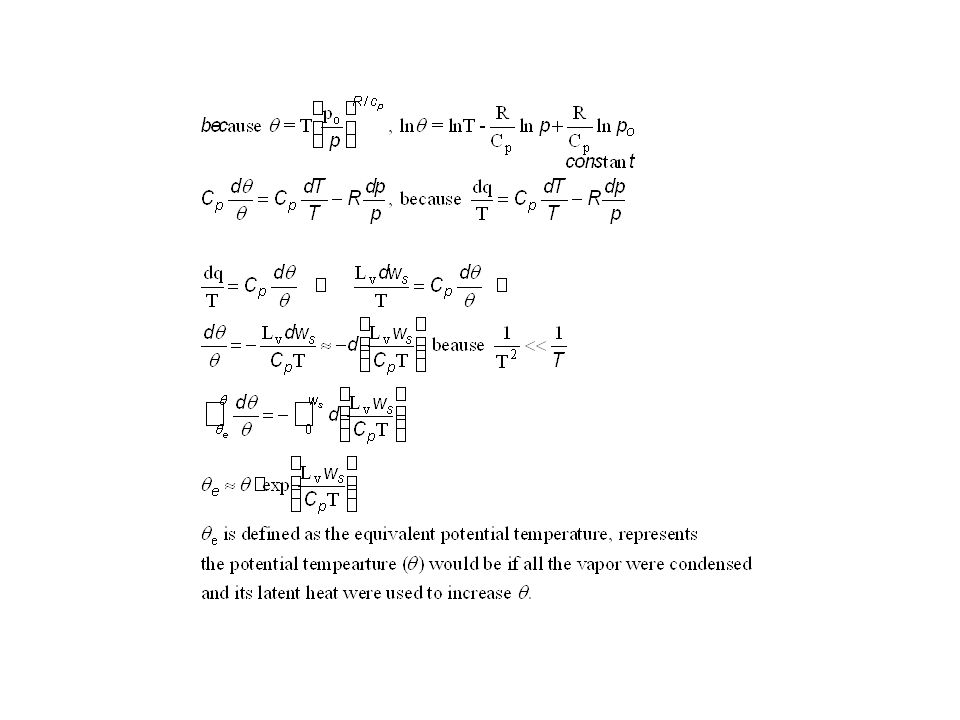
Equivalent potential temperature, qe:
When condensation occurs in a rising air parcel, the latent heat released by condensation, Lvdws, would warm the air parcel, thus against the dry adiabatic cooling, as shown by the 2nd law of thermodynamics Lvdws=CpdT-adp. The equivalent potential temperature, qe, is defined as the potential temperature would be if all the water vapor is condensed and rain out immediately (pseudoadiabatic moist process). qe is derived from the 1st law of thermodynamics -Lvdws=CpdT-adp assuming all the water vapor is condensed and rain out immediately.
. qe is derived from the 1st law of thermodynamics. -Lvdws=CpdT-adp assuming all the water vapor is condensed and rain out immediately.")
14
Equivalent potential temperature, qe is a conserved variable for an pseudoadiabatic adiabatic process, i.e., there is no heat exchange between the system and the ambient, and 100% latent heat release due to condensation of water vapor is used to increase T. The moist adiabatic process is not a true adiabatic process, because of latent heat release. However, we can treat it as it were a adiabatic process if we use qe concept. Qe is similar to q for dry air.

15
Normand’s rule-finding Td and Tw using q and qe lines
Find LCL: Find the q line that intersects with isothermal line that represents surface T. Find the ws line that intersects with Td at 1000 hPa. The intersection between q and ws represents LCL. Finding Tw in Skew T-lnp chart: From the LCL follow the constant qe line down to the sea level (1000 hPa), you will find the wet bulb temperature, Tw at the surface. Q: Why does LCL is determined by Ws line as determined by Td, instead of isothermal line? Q: because Td for Ws decrease with pressure (see p99 Wallace and Hobbs, box 3.5), des/dT=Lv/[Tb(Aair-Awater)>0
, you will find the wet bulb temperature, Tw at the surface. Q: Why does LCL is determined by Ws line as determined by Td, instead of isothermal line Q: because Td for Ws decrease with pressure (see p99 Wallace and Hobbs, box 3.5), des/dT=Lv/[Tb(Aair-Awater)>0.")
16
Net effect of ascent followed by descent:
Once a convective air reaches LCL (point 2), it would ascent follow constant qe line until it reaches cloud top (point 3) and begin descending. The temperature of the descending air depends on the type of moist process during ascending process: If it follows pseudoadiabatic process, all the condensed water falls out, no evaporation would occur during the descending, T follows dry adiabatic process (constant q line) back to surface (point 4, 900 hPa in this case) with T2 (see exercise 3.10 for quantitative description) If it follows saturated moist process, condensed water retained in the air parcel would re-evaporate, T during descending follows qe to LCL (point 2), then follow q back to surface (point 1). Thus, T is reversal. 3 2 4 1 3 T2 2 LCL 4 1 T T2
, it would ascent follow constant qe line until it reaches cloud top (point 3) and begin descending. The temperature of the descending air depends on the type of moist process during ascending process: If it follows pseudoadiabatic process, all the condensed water falls out, no evaporation would occur during the descending, T follows dry adiabatic process (constant q line) back to surface (point 4, 900 hPa in this case) with T2 (see exercise 3.10 for quantitative description) If it follows saturated moist process, condensed water retained in the air parcel would re-evaporate, T during descending follows qe to LCL (point 2), then follow q back to surface (point 1). Thus, T is reversal T2. 2. LCL T. T2.")
17
4.6 Static stability: Static stability of unsaturated air
Determines whether a vertically displayed air parcel would oscillated around its original location or would convect. For example, When the ambient lapse rate, G< Gd, an air parcel would be warmer and more buoyant than the ambient air when it is displayed upward, thus it would continue to move upward without any forcing. Likewise, it would be cooler and heavier than the ambient air when it is displayed downward. Thus, it would continue to sink downward without any external forcing. The ambient atmosphere is unstable for convection. When , G> Gd, an air parcel would be colder and heavier than the ambient air when it is displayed upward, thus it would sink with external forcing,. Likewise, it would be warmer and lighter than the ambient air when it is displayed downward, consequently, rise. Thus, this vertically displaced air parcel would oscillate around its original location. The ambient atmosphere is stable for convection.

18
How do we quantify the influence of G on static instability?
Stability of unsaturated air can be quantified by T’-T: temperature difference between the convecting parcel and ambient atmosphere T’-T>0, unstable, T’-T<0, stable, T’-T=0, neutral Gd-G: lapse rate difference between dry adiabatic process and ambient atmosphere Gd-G<0 or G>Gd: unstable, only occurs near surface in summer desert G<Gd: stable, occurs most of time in reality, G=Gd: neutral dq/dz: vertical slope of potential temperature dq/dz>0: stable, occurs most of time in reality, dq/dz<0: unstable, only occurs near surface in summer desert dq/dz=0: neutral

19
Why? The following derivation shows that air rises, i.e., convects, when G>Gd. In-class exercise: show

20
How does dry stability affect weather and climate?
Static stability affect gravity wave generated by mountains or weather disturbances. The wave length (or frequency) depends on stability, or buoyancy oscillation. Waves would develop if the dynamic wave length is comparable to that corresponding to buoyancy frequency. The buoyancy wave frequency is determined by Stable atmosphere
 depends on stability, or buoyancy oscillation. Waves would develop if the dynamic wave length is comparable to that corresponding to buoyancy frequency. The buoyancy wave frequency is determined by. Stable atmosphere.")
21
Gravity wave induced clouds under stable condition:
What determines the wavelength or the space between cloud rolls?

22
Example: Meteorological measurements show that the lapse rate of the boundary layer is 5 C/km, the temperature is 27C and wind speed is 10 m/s over coast of California. What would be distance between rolls of boundary layer clouds? The buoyancy frequency would be N2=10 m/s/(273+27)K[10K/km-5K/km]/1000m, N=1.29X10⁻² s-1. The gravity waves that form rolls of clouds would have frequency similar to N, thus t=L/U=2p/N L=2pU/N=2X3.14X10m/s/1.29X10-2 s=4.87X10³m=4.87 km The distance between rolls of clouds would be 4.87 km. What would happen to the distance between roll of clouds if wind speed increases to 20 m/s? km Lapse rate increases to 7C/km and wind remains 10m/s? km
K[10K/km-5K/km]/1000m, N=1.29X10⁻² s-1. The gravity waves that form rolls of clouds would have frequency similar to N, thus. t=L/U=2p/N L=2pU/N=2X3.14X10m/s/1.29X10-2 s=4.87X10³m=4.87 km. The distance between rolls of clouds would be 4.87 km. What would happen to the distance between roll of clouds. if wind speed increases to 20 m/s 9.74 km. Lapse rate increases to 7C/km and wind remains 10m/s 6.28 km.")
23
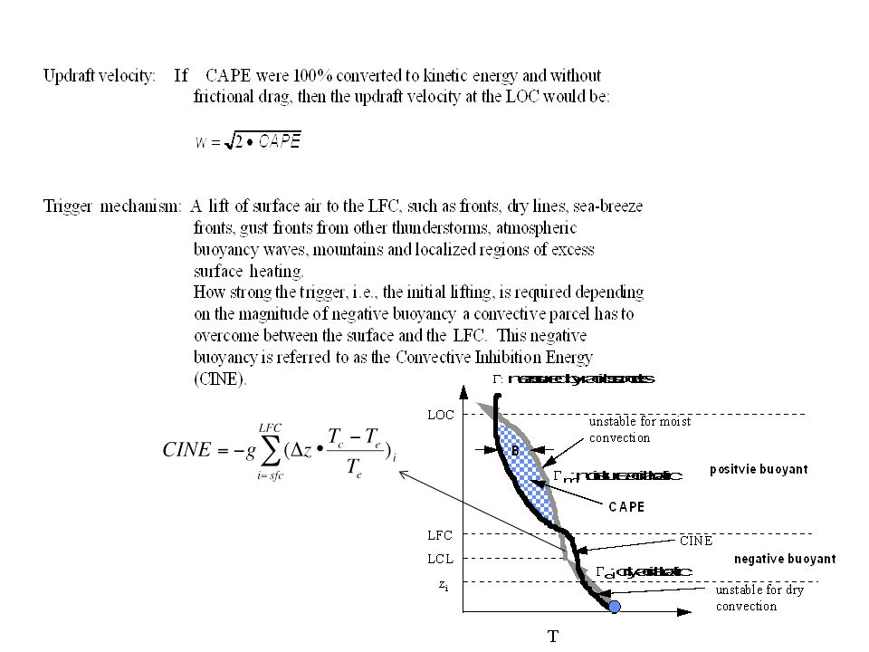
Stability of saturated air:
G<Gd: the atmosphere would be stable for dry convection, however, if G>Gm, or dqe/dz>0, the atmosphere would be unstable for saturated air, referred to as conditional unstable; G<Gm, or dqe/dz<0, the atmosphere would be stable for saturated air, in this case, referred to absolute stable LFC: the level of free convection, referred to the height above which the convecting air would be warmer than the ambient atmosphere, therefore, would rise spontaneously. G Gm Gd LFC LCL

24
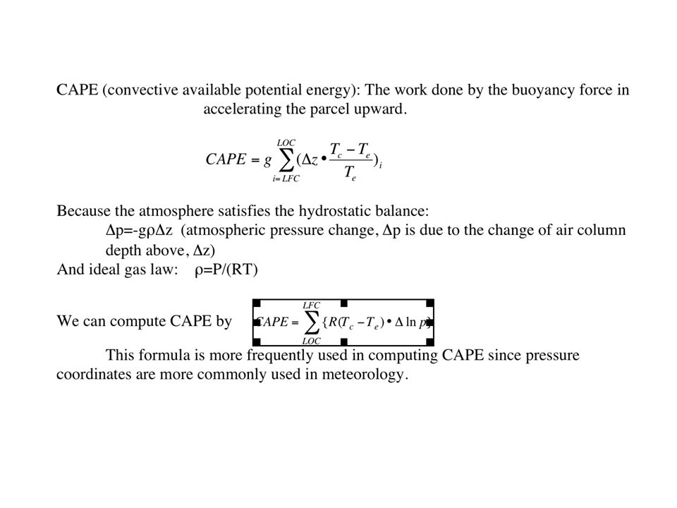
Convective Available Potential Energy
Vertical integrated buoyancy from the level of free convection to the limit of convection

27
How do we compute CAPE and CIN?
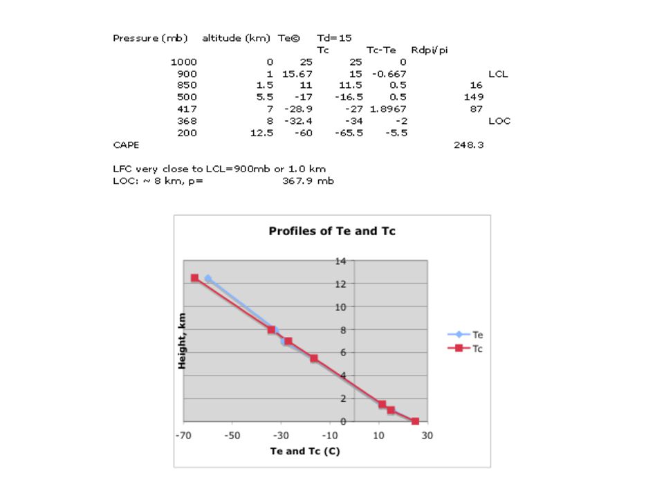
A radiosonde measurement show that a temperature profile as described in the table below. Calculate CAPE and CIN for two different surface moisture conditions, respectively. A) Td=20C, b) Td=15C. Assume the moist adiabatic lapse rate is 7 C/km. In research, the moist lapse rate, Gm, is computed based on condensation in a single plume convection model. Step-1: Plot the temperature profile and use the Te (ambient temperature) and Td (dew point) at the surface to determine the pressure level of free convection (LFC), and pressure level of the limit of convection (LOC). R=287 J K-1kg-1. Step-2: Calculate CAPE for the two values of the Td. Use where Dpi is the pressure increment of each atmospheric between two measurements, pi is the pressure at the center of the each atmospheric layer. LCL for T=25C and Td=20C is 0.5 km and 950 hPa LCL for T=25C and Td=15C is 1 km and 900 hPa. LOC for each case is determined by finding the intersection of Tc and Te profiles after Tc at different pressure levels are computed.
 Td=20C, b) Td=15C. Assume the moist adiabatic lapse rate is 7 C/km. In research, the moist lapse rate, Gm, is computed based on condensation in a single plume convection model. Step-1: Plot the temperature profile and use the Te (ambient temperature) and Td (dew point) at the surface to determine the pressure level of free convection (LFC), and pressure level of the limit of convection (LOC). R=287 J K-1kg-1. Step-2: Calculate CAPE for the two values of the Td. Use where Dpi is the pressure increment of each atmospheric between two measurements, pi is the pressure at the center of the each atmospheric layer. LCL for T=25C and Td=20C is 0.5 km and 950 hPa. LCL for T=25C and Td=15C is 1 km and 900 hPa. LOC for each case is determined by finding the intersection of Tc and Te profiles after Tc at different pressure levels are computed.")
28
Below LCL: Tc=Te(1000 hP)-Gd*(z)
Te values are measured at various pressure levels. We need to compute Tc for convecting air. Below LCL: Tc=Te(1000 hP)-Gd*(z) Between LCL and LOC: Tc=Tc(LCL)-Gm*(z-zLCL) We can compute Tc at 1000hPa, 850hPa, 500 hPa and 200 hPa, and then interpolate the Tc values at the centers of 1000hpa-850hPa layer (925hPa), the hPa layer (625hPa), and hPa layer (350hPa), as shown in the table and figure below. LOC for Td=20C is ~305 hPa, for T=15C is ~ 368 hPa.
-Gd*(z) Between LCL and LOC: Tc=Tc(LCL)-Gm*(z-zLCL) We can compute Tc at 1000hPa, 850hPa, 500 hPa and 200 hPa, and then interpolate the Tc values at the centers of 1000hpa-850hPa layer (925hPa), the hPa layer (625hPa), and hPa layer (350hPa), as shown in the table and figure below. LOC for Td=20C is ~305 hPa, for T=15C is ~ 368 hPa.")
30
Solution for 4b: To compute CAPE and CIN, we use Te and Tc values in each atmospheric layer between the LFC and LOC given in the above discussed tables and the formula Calculate CAPE uses formulas (2) for Td=20C and 15C, respectively, as shown in the tables in previous slides. CAPE(Td=20C)= 837 J/kg, CAPE(Td=15C)=248 J/kg. CIN(Td=20C)=?? Thus, the surface air humidity has strong impact on CAPE and CIN.
 for Td=20C and 15C, respectively, as shown in the tables in previous slides. CAPE(Td=20C)= 837 J/kg, CAPE(Td=15C)=248 J/kg. CIN(Td=20C)= Thus, the surface air humidity has strong impact on CAPE and CIN.")
31
4.7. The 2nd law of thermodynamics and Clausius-Clapeyron equation
The Clausius-Clapeyron equation describes the change of saturation vapor pressure on T. It is derived based on the 2nd law of thermodynamics, maximum energy can be extracted from state change, based on the Carnot cycle. Work added to the system adiabically Heat, Q1 extracted from the system Work removed from the system Heat, Q2 added to the system

32
What control atmospheric water vapor:
The saturation mixing ratio decreases rapidly with decrease of temperature in a rising air. Clausius-Clapeyron equation

33
Water vapor feedback is the strongest atmospheric feedback to climate change. How does earth temperature change influence atmospheric water vapor change? Assuming that the relative humidity of the atmosphere is fixed at 70% and the surface pressure is 1000mb, the pre-industry global surface temperature was 15C, compute the change of atmospheric water vapor near the surface in the sub-polar region for the following two cases: Assume that the temperature during the last glacial maximum (LGM) was about 6C colder than that of the pre-industrial period of the 20th century ( ), how much change in the atmospheric specific humidity do you expect between the LGM and pre-industry era? Assume that the surface temperature would be 6C warmer by the end of the 21st century than that of the pre-industrial period of the 20th century based on the IPCC AR4 projections, how much change in the atmospheric specific humidity do you expect between the end of the 21st century and pre-industry era? Based on your results of a) and b), discuss whether the change of atmospheric water vapor concentration would be stronger or weaker by the end of the 21st century compared to that of the last glacier maximum period. The change of water vapor by the end of the 21st century would be greater than that between the LGM and pre-industrial period.
 was about 6C colder than that of the pre-industrial period of the 20th century ( ), how much change in the atmospheric specific humidity do you expect between the LGM and pre-industry era Assume that the surface temperature would be 6C warmer by the end of the 21st century than that of the pre-industrial period of the 20th century based on the IPCC AR4 projections, how much change in the atmospheric specific humidity do you expect between the end of the 21st century and pre-industry era Based on your results of a) and b), discuss whether the change of atmospheric water vapor concentration would be stronger or weaker by the end of the 21st century compared to that of the last glacier maximum period. The change of water vapor by the end of the 21st century would be greater than that between the LGM and pre-industrial period.")
34
Discussion: Why do storm intensity and extreme rainfall tend to increase, esp. in tropics, under a warmer climate?

35
Summary: Most of time, the atmospheric stability is either stable or conditionally unstable. Stable condition: a vertical disturbance can oscillation about its original height driven by buoyancy oscillation and form gravity waves. Unstable: moist convection may occur Saturation vapor pressure change exponentially with temperature, leading to rapid condensation in rising air, or increase of water vapor with T. Thus, rainfall intensity and specific humidity increase rapidly in the atmosphere with T.

Similar presentations


 Energy absorbed Energy released Solid (Ice) melting evaporation deposition freezing.>")


