Download presentation
Presentation is loading. Please wait.

1
Standard Data Management Project
USDA-Forest Service Geospatial ‘09, April 28th, 2009 Jim Keys, WO-EMC, Pete Kilbourne Manti-La Sal NF, Aaron Burk, Wayne NF 2008 Oct 21 Revised Ver 2 JK

2
Topics Overview of the Standard Data Management Project – Jim Keys
Demo of project tools being pilot tested – Aaron Burk Audience discussion/interaction on some issues related to work flows coming out of the interview process – Pete Kilbourne

3
Standard Data Management Project Overview
Jim Keys begins presentation first 15 draft slides of current draft. Aaron Burk then gives Data QE and IQT demo. Pete Kilbourne then leads “SDM” future discussion. Jim Keys then closes with “How you can participate”. 3 Topics Overview SDM Background Pilot tools Demo Get some information from you Key Terms if neededv Inventory: To survey an area or entity for determination of such data as contents, condition, or value, for specific purposes such as planning, evaluation, or management. An inventory activity may include an information needs assessment; planning and scheduling; data collection, data entry, storage and maintenance; product development; evaluation; and reporting phases. Monitoring: A systematic process of collecting information to evaluate changes in actions, conditions, and relationships over time and space or progress toward meeting desired conditions or plan objectives. Assessment: An analysis and interpretation of the social, economic, or ecological characteristics of an area using scientific principles to describe existing conditions as they affect sustainability. Assessments provide the foundation of independent information upon which to build conservation strategies and management decisions; and against which alternative approaches can be evaluated and modified. Evaluation: An appraisal and study of social, economic, and ecological conditions and trends relevant to a unit. The analysis of monitoring data that produces information needed to answer specific monitoring questions. Evaluation may include comparing monitoring results with a predetermined guideline or expected norm that may lead to recommendations for changes in management, a land management plan, or monitoring plan (emphasis added). Evaluations provide an updated compilation of information for use in environmental analysis of future project and activity decisions. Jim Keys, WO-EMC/Resource Information Group SDM Project Business Lead and Current Project Manager 2008 Oct 21 Revised Ver 2 JK
. Evaluations provide an updated compilation of information for. use in environmental analysis of future project and activity decisions. Jim Keys, WO-EMC/Resource Information Group. SDM Project Business Lead and Current Project Manager Oct 21 Revised Ver 2 JK.")
4
Project History Chartered as 2006 IT effort
Business Lead and Project Manager: Jim Keys Co-Sponsorship Director of EMC – Greg Smith (Acting) CIO - Vaughn Stokes Core team with proposed additions across deputy area programs The Chief Information Officer (CIO) and the Director of Ecosystem Management Coordination (EMC) chartered this project. The Information Resources Board (IRB) approved the project scope, schedule, and budget. The project manager has convened a small core team and continues to add team members to represent field and program offices across deputy areas and administrative levels. 2008 Oct 21 Revised Ver 2 JK
 CIO - Vaughn Stokes. Core team with proposed additions across deputy area programs. The Chief Information Officer (CIO) and the Director of Ecosystem Management Coordination (EMC) chartered this project. The Information Resources Board (IRB) approved the project scope, schedule, and budget. The project manager has convened a small core team and continues to add team members to represent field and program offices across deputy areas and administrative levels Oct 21 Revised Ver 2 JK.")
5
Overall project scope Develop implementation policy and guidance to implement policies in FSM 1940 “Inventory, Monitoring, and Assessment Activities” and provide the field with relevant tools. 2008 Oct 21 Revised Ver 2 JK

6
Agency Business Objectives
The objectives for managing inventory, monitoring, and assessment activities are: Provide the information necessary for achieving the agency’s mission, goals, objectives, and business needs that fulfill information quality guidelines for objectivity, utility, and integrity; Support an adaptive land management process that includes social, economic, and ecological evaluations; and Obtain order, consistency, and efficiency across the agency. By chartering the SDM project the Forest Service seeks to integrate business operations and resource information management and develop and implement good business practices. Fulfilling these objectives and policies presents the Forest Service with challenges in these key areas:[1] Defining a clear vision and mission for inventory and monitoring tasks; Providing leadership continuity and accountability across all levels of the agency; Funding processes and controls that effectively support the mission of the agency and management of resource information; Keeping the IM&A policies and objectives aligned with resource management objectives; Implementing easy-to-use tools that are based on current and evolving business-driven needs that ease the burden on staff and gain efficiencies; and Integrating, sharing, and reusing services within and across deputy areas to gain efficiencies and improve effectiveness. 2008 Oct 21 Revised Ver 2 JK

7
SDM Project Focus The SDM Project focuses on the following three policies for resource inventory, monitoring and assessment activities: Be coordinated through a national integrated program planning process that addresses information needs related to all agency business requirements; Use a standards-based approach and framework for information management and related business operations; and Foster and realize opportunities for collaboration, cooperation, and coordination across Forest Service deputy area programs and with agency partners, including the public; local, state, and other federal agencies; and non-governmental organizations. The SDM project team will formulate recommendations for guidance and tools to enable the agency to implement these policies based on findings from a series of interviews with representatives across all deputy and administrative areas of the agency. Because “what ultimately counts is what happens on the ground,”[1] the Forest Service expects national projects to support field operations by leveraging existing resources (e.g. guidance, teams, and systems) while transparently contributing to efficient program management. [1] 2007, Dale Bosworth, Chief; in USDA Forest Service Strategic Plan FY ; FS-880 2008 Oct 21 Revised Ver 2 JK
 while transparently contributing to efficient program management. [1] 2007, Dale Bosworth, Chief; in USDA Forest Service Strategic Plan FY ; FS Oct 21 Revised Ver 2 JK.")
8
A work in progress Published FSM 1940 for resource inventories, monitoring and assessment (IM&A) activities. Completed a line of business study (LOB) – highlighted specific areas where the prioritization, efficiency, and effectiveness of IM&A tasks might be improved through better technology, standards, and business practices Currently involved in a process called solution design where we are interviewing stakeholders across the agency for further study those capability areas identified in the line of business study 2008 Oct 21 Revised Ver 2 JK
 – highlighted specific areas where the prioritization, efficiency, and effectiveness of IM&A tasks might be improved through better technology, standards, and business practices. Currently involved in a process called solution design where we are interviewing stakeholders across the agency for further study those capability areas identified in the line of business study Oct 21 Revised Ver 2 JK.")
9
LOB Capability Areas Inventory, monitoring and assessment cataloging and tracking; Task cost estimation tools; Standard data access/integration methods; Assessment tools to help ensure alignment of “plans” with information and inventory, monitoring, and assessment tasks; National inventory and monitoring guidance; Information quality standards; and Processes that enable creation of inventory, monitoring, and assessment metrics, targets, and appraisals.
![]()
10
What we are doing Address each of the seven IM&A Line of Business capability areas with focus on significant aspects and opportunities to improve work flow (processes). Examine the degree to which current agency business can be served by tools that replace the capabilities of four previous tools: Protocol Database, Standard Data Evaluation Tool (SDET), Inventory and Monitoring Program Planning (IMPP), and the Resource Mapping Evaluation Tool (RMET). Integrate existing and new processes and systems to minimize duplication of effort and broaden collaboration and ownership across staff and deputy areas. 2008 Oct 21 Revised Ver 2 JK
. Examine the degree to which current agency business can be served by tools that replace the capabilities of four previous tools: Protocol Database, Standard Data Evaluation Tool (SDET), Inventory and Monitoring Program Planning (IMPP), and the Resource Mapping Evaluation Tool (RMET). Integrate existing and new processes and systems to minimize duplication of effort and broaden collaboration and ownership across staff and deputy areas Oct 21 Revised Ver 2 JK.")
11
What we are doing Provide guidance and tools that facilitate efficient flow of work. The primary activities within this workflow include identifying information needs, choosing or developing standards applied to information, acquiring information (e.g. work planning and budgeting), managing information, evaluating information, and monitoring how well information meets agency business needs. Author inventory, monitoring, and assessment directives (handbook and guidance) that apply to all administrative levels and have the support of all deputy areas. 2008 Oct 21 Revised Ver 2 JK
, managing information, evaluating information, and monitoring how well information meets agency business needs. Author inventory, monitoring, and assessment directives (handbook and guidance) that apply to all administrative levels and have the support of all deputy areas Oct 21 Revised Ver 2 JK.")
12
Operating Principles Use a phased approach to: (1) identify requirements, (2) propose and pilot test solutions, (3) evaluate impact to the field, (4) obtain approval to proceed with each “deliverable,” and (5) complete approved implementation plans. Author FSH 1909.xx including descriptions of the standards based approach and framework, coordination and collaboration, and program management and planning processes. Facilitate the chartering of subordinate teams to develop guidance with implementation plans. Implementation plans will include impact assessment of long-term support and use of guidance and tools. Favor solutions that improve the efficiency of agency work flows, procedural standards, and budgetary direction, and that hold programs to account for sustaining efficient processes that prevent or minimize long-term costs. Develop and recommend solutions that have minimal and transparent impact to the field. 2008 Oct 21 Revised Ver 2 JK
 identify requirements, (2) propose and pilot test solutions, (3) evaluate impact to the field, (4) obtain approval to proceed with each deliverable, and (5) complete approved implementation plans. Author FSH 1909.xx including descriptions of the standards based approach and framework, coordination and collaboration, and program management and planning processes. Facilitate the chartering of subordinate teams to develop guidance with implementation plans. Implementation plans will include impact assessment of long-term support and use of guidance and tools. Favor solutions that improve the efficiency of agency work flows, procedural standards, and budgetary direction, and that hold programs to account for sustaining efficient processes that prevent or minimize long-term costs. Develop and recommend solutions that have minimal and transparent impact to the field Oct 21 Revised Ver 2 JK.")
13
Operating Principles Emphasize integration and communication of agency business needs and requirements over new IT development. Rely on a team with members who represent field and program offices across deputy areas. Solicit input from across agency deputy areas and administrative levels through a series of interviews and studies that identify requirements, assess benefits and costs, and recommend teams to follow through with development of deliverables. Minimize tool-building. Build only what is necessary for integration of budget, accountability, and policy; or necessary to pull information together from existing data repositories and applications. For example, favor use of Geospatial Interface (GI) to access data through user friendly interface over creation of entirely new IT application separate from existing systems. Avoid new IT development effort by this project team in favor of having other more experienced agency teams develop IT solutions. Manage SDM as a client of other IT development teams and projects (e.g. NRIS, NIMS, FSVEG, IBE); CIO responsible for implementation and support. Collaborate with other teams to facilitate any important adjustments to their scope, budget, and schedule based on executive approvals and support from field resource programs and specialists. Minimize data redundancy, protect data confidentiality, and ensure data integrity. Encourage and favor solutions that promote efficient management of shared data across agency systems and programs. 2008 Oct 21 Revised Ver 2 JK
 to access data through user friendly interface over creation of entirely new IT application separate from existing systems. Avoid new IT development effort by this project team in favor of having other more experienced agency teams develop IT solutions. Manage SDM as a client of other IT development teams and projects (e.g. NRIS, NIMS, FSVEG, IBE); CIO responsible for implementation and support. Collaborate with other teams to facilitate any important adjustments to their scope, budget, and schedule based on executive approvals and support from field resource programs and specialists. Minimize data redundancy, protect data confidentiality, and ensure data integrity. Encourage and favor solutions that promote efficient management of shared data across agency systems and programs Oct 21 Revised Ver 2 JK.")
14
Operating Principles (If you didn’t get it)
Emphasize integration and communication of agency business needs and requirements over new IT development. Rely on a team with members who represent field and program offices across deputy areas. Solicit input from across agency deputy areas and administrative levels through a series of interviews and studies that identify requirements, assess benefits and costs, and recommend teams to follow through with development of deliverables. Minimize tool-building. Build only what is necessary for integration of budget, accountability, and policy; or necessary to pull information together from existing data repositories and applications. For example, favor use of Geospatial Interface (GI) to access data through user friendly interface over creation of entirely new IT application separate from existing systems. Avoid new IT development effort by this project team in favor of having other more experienced agency teams develop IT solutions. Manage SDM as a client of other IT development teams and projects (e.g. NRIS, NIMS, FSVEG, IBE); CIO responsible for implementation and support. Collaborate with other teams to facilitate any important adjustments to their scope, budget, and schedule based on executive approvals and support from field resource programs and specialists. Minimize data redundancy, protect data confidentiality, and ensure data integrity. Encourage and favor solutions that promote efficient management of shared data across agency systems and programs. 2008 Oct 21 Revised Ver 2 JK
 to access data through user friendly interface over creation of entirely new IT application separate from existing systems. Avoid new IT development effort by this project team in favor of having other more experienced agency teams develop IT solutions. Manage SDM as a client of other IT development teams and projects (e.g. NRIS, NIMS, FSVEG, IBE); CIO responsible for implementation and support. Collaborate with other teams to facilitate any important adjustments to their scope, budget, and schedule based on executive approvals and support from field resource programs and specialists. Minimize data redundancy, protect data confidentiality, and ensure data integrity. Encourage and favor solutions that promote efficient management of shared data across agency systems and programs Oct 21 Revised Ver 2 JK.")
15
Project Deliverables Recommendations for guidance to implement agency resource information policy; Analysis of requirements for tools and processes to improve effectiveness and efficiency of resource information to support the work of the Forest Service; Pilot tests of tools, documented user feedback and recommendations for refinements; and Completed guidance and tools with implementation plans as approved by executive sponsors. The project deliverables apply to all study areas on next slide (slide 13) The recommendations and requirements[1] will be identified through a cycle of interviews, proposals, and pilot tests. The project will ensure that the agency evaluates the effectiveness, efficiency, and impact of proposed guidance and tools. Each step will be subject to review and approval by executive sponsors. The initial topic areas[2] for interviews are: [1] The team will use stages of requirements analysis and solution design similar to those used in eGov projects. This process is further described in section titled “Terminology” at the end of this document. [2] The Line of Business study report uses the term “capability areas” which is synonymous with “topic areas.” 2008 Oct 21 Revised Ver 2 JK
 The recommendations and requirements[1] will be identified through a cycle of interviews, proposals, and pilot tests. The project will ensure that the agency evaluates the effectiveness, efficiency, and impact of proposed guidance and tools. Each step will be subject to review and approval by executive sponsors. The initial topic areas[2] for interviews are: [1] The team will use stages of requirements analysis and solution design similar to those used in eGov projects. This process is further described in section titled Terminology at the end of this document. [2] The Line of Business study report uses the term capability areas which is synonymous with topic areas Oct 21 Revised Ver 2 JK.")
16
Project Schedule Numerous decision points for Executive Sponsors
FOR MORE INFO... Project management plan documents available on FS Teamroom (Jim Keys - Project Manager at or ) 2008 Oct 21 Revised Ver 2 JK
 2008 Oct 21 Revised Ver 2 JK.")
17
Project Outcomes 2008 Oct 21 Revised Ver 2 JK

18
Demo: Current SDM Project Tools
Aaron Burk - SDM Project Core Team Wayne National Forest –Resource Information Manager Jim can intro or give it to Aaron at this point 2008 Oct 21 Revised Ver 2 JK

19
Current SDM Project Tools
Pilot Testing Data QE (Quality Evaluation) IQT (Information Quality Tool) Jim can intro or give it to Aaron at this point 2008 Oct 21 Revised Ver 2 JK
 IQT (Information Quality Tool) Jim can intro or give it to Aaron at this point Oct 21 Revised Ver 2 JK.")
20
DataQE (Quality Evaluation)
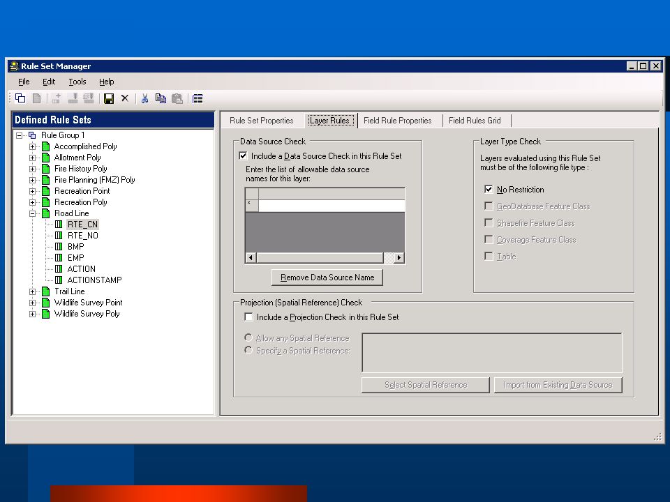
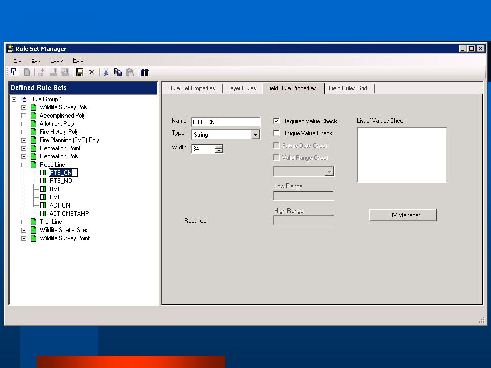
DataQE Background GIS data quality evaluation tool for ArcMap Provides users with simple interface for defining and managing “rule set” data. Provides GIS professionals with quick & easy way to perform customizable QA checks on attribute tables Coverage, Shapefile, Geodatabase layers PAS drove tool development to meet the Strategic Measure because it had to be done. Due to Chief’s requirement. 2008 Oct 21 Revised Ver 2 JK

21
Information Quality Tool
Information Quality Tool (IQT) Background is an application that generates an evaluation of the data quality of certain aspects of standard GIS layers Evaluation results will generate performance measure statistics to the Performance Accountability System (PAS) Makes upward reporting more transparent, less burdensome IQT is driven by IQT and IQT report Tool describe how the two fit together. Discuss why these tools were developed during the Line of Business and Interview process. Due to strategic measure 5.1 a tool needed to be developed in a timely way generate the information required by the Performance Accountability System. The PAS # for IM&A tasks is a % This is based on the amount of “data that has been collected to current standard” for a susbset (see below) of GIS layers in the national Data dictionary. Layers reviewed in 2007 & 2008 Accomplishment Activity Polys Fire Planning Polys Fire History Polys Allotment Polys Recreation Sites Points Recreation Sites Polys Road Travel Routes Trail Travel Routes Wildlife Surveys Points Wildlife Surveys Polys 2008 Oct 21 Revised Ver 2 JK
 Background. is an application that generates an evaluation of the data quality of certain aspects of standard GIS layers. Evaluation results will generate performance measure statistics to the Performance Accountability System (PAS) Makes upward reporting more transparent, less burdensome. IQT is driven by IQT and IQT report Tool describe how the two fit together. Discuss why these tools were developed during the Line of Business and Interview process. Due to strategic measure 5.1 a tool needed to be developed in a timely way generate the information required by the Performance Accountability System. The PAS # for IM&A tasks is a % This is based on the amount of data that has been. collected to current standard for a susbset (see below) of GIS layers in the national Data dictionary. Layers reviewed in 2007 & Accomplishment Activity Polys. Fire Planning Polys. Fire History Polys. Allotment Polys. Recreation Sites Points. Recreation Sites Polys. Road Travel Routes. Trail Travel Routes. Wildlife Surveys Points. Wildlife Surveys Polys Oct 21 Revised Ver 2 JK.")
22
IQT Data QE Demo Check Data Dictionary compliance
Create Rule sets for local data, in the future. Run your own IQT report User friendly Check Data Dictionary compliance Create Rule sets for local data, in the future. Different file types. Run your own IQT report. 2008 Oct 21 Revised Ver 2 JK

23
Data dictionary complianace
2008 Oct 21 Revised Ver 2 JK

24
Launceh data QE 2008 Oct 21 Revised Ver 2 JK

25
Data QE Rule Sets

29
IQT Report Tool

31
Pilot Stage at this point still gaining knowledge before rollout.
2008 Oct 21 Revised Ver 2 JK

32
Resource Information Mgr.
Exploring Workflows for Inventory, Monitoring, and Assessment Activities During the SDM Project Solution Definition Process Geospatial 09 Snowbird, UT April 2009 Pete Kilbourne, Resource Information Mgr. Manti-La Sal NF

33
Purpose of this presentation
SDM team is looking at workflows for inventory, monitoring and assessment activities. to help identify requirements for the 7 Capability Areas from LOB Study Subsequently conducting interviews To identify requirements at different organizational levels throughout the FS And will be asking for your input on issues surrounding workflows and LOB requirements Better job of developing user requirements.

34
HELP!!! WE NEED YOUR INPUT INTO THE REQUIREMENTS FOR STANDARD DATA MANAGEMENT YOU CAN GIVE US INPUT BY: Participating in the interview process Becoming part of a user group for standard data management Piloting processes and tools Reviewing and commenting on FSH direction and guidance

35
Topics What is a workflow for inventory, monitoring and assessment activities? Why are we looking at workflows? How will they be used? Introduce a workflow at the field level for basic inventory data highlight some issues we might encounter that require (field) feedback relating to that workflow. Help us identify the requirements related to the 7 capability areas (LOB Study) Get your ideas about other workflows that are important to your business. Why – tie to real work and user experience How – to make sure requirements mesh with the work we do. 2008 Oct 21 Revised Ver 2 JK
 feedback relating to that workflow. Help us identify the requirements related to the 7 capability areas (LOB Study) Get your ideas about other workflows that are important to your business. Why – tie to real work and user experience. How – to make sure requirements mesh with the work we do Oct 21 Revised Ver 2 JK.")
36
What do we mean by workflow for an activity?
A workflow describes a sequence of logical steps needed to accomplish some activity. More specifically it includes: Tasks procedural steps organization or people involved inputs and outputs Workflows can be described for field, region and national activities.

37
WHY and How we use Workflows
To explain capability areas in a way that is familiar to you Models the way we work. And grounds requirements for capability areas to the way we work in the real world. How Build requirements around workflows that model important aspects of our work.

38
Possible workflow(s) we might encounter
Planning, preparing and scheduling an inventory Data collection or acquiring the data Selection and use of Protocols (data standards and methods) Quality assurance and control Publication of data Project analysis and classifications Monitoring (guides, plans, schedules, procedures, reporting) Developing protocols Linking the costs of basic inventory with funding, accomplishment, and performance accountability reporting systems 6 steps 2008 Oct 21 Revised Ver 2 JK
 Quality assurance and control. Publication of data. Project analysis and classifications. Monitoring (guides, plans, schedules, procedures, reporting) Developing protocols. Linking the costs of basic inventory with funding, accomplishment, and performance accountability reporting systems. 6 steps Oct 21 Revised Ver 2 JK.")
39
The purpose and scope will guide a specific workflow and resulting products
If the purpose is to collect or acquire data for a specific business need? the product is data to meet that business need If the purpose is to integrate existing data sets, budget, and performance and accountability systems? the product or output may be a set of integrated processes, and applications or tools Workflows are similar ?????????????? inputs and outputs are different. 2008 Oct 21 Revised Ver 2 JK

40
Explore as an example work flow for Basic Field Level Inventory
Example, Issues, Discussion, Feedback

41
Review of SDM Topics As we go, look for the underlined SDM topics in workflow
Inventory, monitoring and assessment cataloging and tracking; Task cost estimation tools; Standard data access/integration methods; Assessment tools to help ensure alignment of “plans” with IM&A tasks; National inventory and monitoring guidance; Information quality standards; and Processes that enable creation of IM&A metrics, targets, and appraisals. Focus on underlined topics which will specifically tie to workflow 2008 Oct 21 Revised Ver 2 JK

42
Cycle back through the example workflow Focus issues
Example workflow Base inventory (transportation, wildlife, recreation, vegetation, etc. PLAN BASE INVENTORY What, why, how, when, where Plan Update/Revise Revise Identify continuing needs What’s left to do What processes should be changed Create, publish, document and maintain base Do Check Use and check (useful, effective, and efficient)
")
43
ISSUES Information Needs of Assessments
Measuring status, progress with focus on spatial completeness Linking Data needs to the budget We are using Workflows ties to what you are familiar in your work 2008 Oct 21 Revised Ver 2 JK

44
Select and fund Projects
PLAN BASE INVENTORY Starting with Needs Enter into Annual Workplan Refined costs and methods of acquisition Pick performance measures INV-DAT_ACQ set targets acres Identify Information Needs Catalog and tracking Alignment with Plans Information quality Annual budget Process Select and fund Projects Data Requirements (Protocols & Data Stds. Enter into out-year budget Process (may just be total costs by BLI like NFIM Data Status & Evaluation Extent and Quality List of feasible data Projects (budget and personnel) Identify Data GAPS Extent and quality
 Identify Data. GAPS. Extent and quality.")
45
INA For Data Needs – Base Inventory
This example is limited to Data needs for developing a base of GIS and related inventory data Primary assumption - build once, use many With that in mind, the questions are Which data to meet business needs? What data requirements?

46
INA – INFORMATION NEEDS ASSESSMENT
Depth and detail of INA Depends on where we are in the game Early days, starting from scratch Analyzed business functions (planning, project implementation and NEPA) Identified resource questions that support those functions. Still doing some of this Change management
 Identified resource questions. that support those functions. Still doing some of this. Change management.")
47
The agency decided “what data” a while ago in one form or another
Reflected in DD and Nat. App. data structures Subject to change management Can step back to “what is the resource question and data requirements” Subject to unique regional or local data needs Ex. wetlands when we evaluate the usefulness of our data. 2008 Oct 21 Revised Ver 2 JK

48
Seems like we are mostly picking our data needs from a list?
Not every forest is going to need everything in the Data Dictionary and Nat. Applications. Nor can they afford it Must prioritize considering available funds most important resource issues

49
Not every forest has a range program

50
Purpose of INA in Base Inventory Workflow – At this Stage
Identify data needs on a particular unit leading toward identification of data gaps that need to be filled Prioritization applicability to the unit Management priorities Cost and Available funds Funding Accomplishment

51
Discussion Thoughts, comments? What do you do?
Detailed INA process Or simply pick DD layers ? What are your requirements for an INA? Would any INA tools be helpful?

52
Measuring status, progress with focus on spatial completeness

53
Select and fund Projects
PLAN BASE INVENTORY Data status, Evaluation, and Gaps Enter into Annual Workplan Refined costs and methods of acquisition Pick performance measures INV-DAT_ACQ set targets acres Identify Information Needs Data Requirements (Protocols & Data Stds. Annual budget Process Select and fund Projects Enter into out-year budget Process (may just be total costs by BLI like NFIM Data Status & Evaluation Extent and Quality Catalog and tracking Information quality List of feasible data Projects (budget and personnel) Identify Data GAPS Extent and quality Catalog and tracking Information quality metrics
 Identify Data. GAPS. Extent and quality. Catalog and tracking. Information quality. metrics.")
54
Data status, Evaluation, and Gaps Concepts (some unofficial terms)
Status - How do we know how much data we have? Completeness - How do we know when we have the data we need? at the quality we need At the geographic extent we need. Data Gaps- How do we know what to do next? What data we need develop next? what data needs to be fixed or updated? Progress – How do we measure how far along we are? Meeting our goals

55
Data status Two components of status Quality? Completeness?
Has it been collected to the needed currency ,accuracy, precision? Is it consistent with FS standards Data QE and IQT Does it meet protocol requirements? Completeness? Does the data cover the area where we need data? Geographic extent Does it contain the attributes and values needed?

56
Data Gaps, Progress, Spatial Completeness How do we calculate it
Data Gaps, Progress, Spatial Completeness How do we calculate it? Do we care? Total Area where we need data Data Gap (area where data needs to be acquired) - = Current area inventoried Current area inventoried Total Area where we need data = PROGRESS as a percentage ISSUES How do we establish the total area where we need data? How do we measure the data we have? How do we identify the data gaps? What units of measure should we use? Acres, number of features, miles?
 - = Current area inventoried. Current area inventoried. Total Area where we need data = PROGRESS as a percentage. ISSUES. How do we establish the total area where we need data How do we measure the data we have How do we identify the data gaps What units of measure should we use Acres, number of features, miles")
57
Status Graphic Approach
No mapping – needed by priority In Progress Completed

58
How do we measure completeness
for point data? Example - Features do not cover entire inventory area. Inventory not complete What is the numerator? SITES (points) – what we found? number of sites (487)? or area represented by sites Acre conversion (487x 5 acres = 2435 acres) Or AREA INVENTORIED SO FAR where we looked (pink area)? 42,337 acres What is the denominator? SITES we should find? Unknown upfront number of sites? Or area represented by sites Or AREA WHERE WE NEED DATA (beige) Can establish this up-front 122,878 acres Current inventory PROGRESS as a percentage (X 100) = Total inventory needed
 – what we found number of sites (487) or area represented by sites. Acre conversion (487x 5 acres = 2435 acres) Or AREA INVENTORIED SO FAR where we looked (pink area) 42,337 acres. What is the denominator SITES we should find Unknown upfront. number of sites Or area represented by sites. Or AREA WHERE WE NEED DATA (beige) Can establish this up-front. 122,878 acres. Current inventory. PROGRESS as a percentage (X 100) = Total inventory needed.")
59
Discussion Thoughts, comments? How do you measure progress?
Do you plan to inventory an area, distance or a certain number of features? What are your requirements for measuring status and progress? Would tools assist in measuring status and progress be needed?

60
Linking Data needs to the budget
How do we make the information needs known on the budget side?

61
PLAN BASE INVENTORY Enter into Annual Workplan
Refined costs and methods of acquisition Pick performance measures INV-DAT-ACQ set targets acres cost estimation Metrics, targets Identify Information Needs Annual budget Process Select and approve Projects cost estimation Metrics Alignment with plans Data Requirements (Protocols & Data Stds. Enter into out-year budget Process (may just be total costs by BLI like NFIM cost estimation Metrics, targets Alignment with plans Data Status & Evaluation Extent and Quality List of feasible data Projects (budget and personnel) Identify Data GAPS Extent and quality
 Identify Data. GAPS. Extent and quality.")
62
Out- Year budget Example Performance Measure INV-DAT-ACQ - Inventory Data Acquired
Very general numbers Summary for all inventories planned total acres and $ Often not tied to specific data needs Often based on what we did in previous years Will this lead to the appropriate level of funding? Could the SDM project help make a better connection between needs and budget? Total acres

63
Annual Work-plan Establishes funding annual funding of IM&A projects If individual work-plans done for specific inventories, Can be tied directly to meeting specific data needs Manual process If single work-plans done for all inventories No identifiable tie to specific data needs. Potential area of integration for the SDM project to link needs to budget? Target and accomplishment (same area of inventory vrs area of features problem)
")
64
Discussion Thoughts, comments?
How do you calculate out-year acres of inventory and $? Area to be inventoried or area of features you might find? Do you consider specific inventory needs to make out year estimates? Do you make individual and general workplans? Advantages? Disadvantages? What are your requirements for linking information needs to budget? Would tools help ? to feed or at least inform the budget about specific data needs?

65
Closeout - Review Workflows Requirements for capability areas
PLAN Alignment with Plans Catalog and tracking Information quality cost estimation Metrics, targets Plan Issues (INA, completeness,budget) Update/Revise Do Revise Identify continuing needs What’s left to do What processes should be changed Information quality alignment of “plans” with IM&A tasks Catalog and track Create, publish, document and maintain Information quality data access/integration Metrics, targets Catalog and track Check Use and check (useful, effective, and efficient) Information quality alignment of “plans” with IM&A tasks metrics, targets, and appraisals
 Update/Revise. Do. Revise. Identify continuing. needs. What’s left to do. What processes. should be changed. Information quality. alignment of plans with IM&A tasks. Catalog and track. Create, publish, document. and maintain. Information quality. data access/integration. Metrics, targets. Catalog and track. Check. Use and check (useful, effective, and efficient) Information quality. alignment of plans with IM&A tasks. metrics, targets, and appraisals.")
66
HELP!!! WE NEED YOUR INPUT INTO THE REQUIREMENTS FOR STANDARD DATA MANAGEMENT YOU CAN GIVE US INPUT BY: Participating in the interview process Becoming part of a user group for standard data management Piloting processes and tools Reviewing and commenting on FSH direction and guidance Identifying workflows that are important for your business. Questions or comments Get with Aaron, Jim, or Pete afterward

Similar presentations


 in.>")
 Circular A-16 Supplemental Guidance, is the coordination of Federal geospatial.>")
>")


>")