Download presentation
Presentation is loading. Please wait.

1
Welcome to the Right of Way Plan Development Pre-Qualification Training

2
Brett A. Shearer, Right of Way Specialist ODOT Central Office
Worked for ODOT for over 20 years 1987 Attended University of Akron in Drafting and Survey Tech. 1989 Draftsmen in District 3, Production and Survey 1994 Survey Technician in Aerial Engineering 1995 R/W Plan Specialist in the Office of Real Estate 2000 R/W Plan Specialist in the Office of Production

3
Right of Way Plan Development Pre-Qualification
Instructors: Dave Dicke, ODOT District 2 REA Doug Raters, P.E. ODOT District 8 REA Mike Ware, P.S. ODOT Office of Production Jim Kenyon, P.S. ODOT District 3 SOM John Messmore, P.S. ODOT District 4

4
Welcome & Introduction
Sign In Sheet You MUST sign in each morning in order to receive your certificate Location of Restrooms Location of Cafeteria and Restaurants Smoking areas Some slides will be difficult to read Please hold Questions to the end of speaker’s presentation

5
Right of Way Plan Development Training Manual
Course Agenda Table of Contents Biography for each speaker Power Point Slide show Appendices CPD Credits R/W Plan Manual Sections 3100, 3200 & 3300 Quizzes Will be given after the morning and afternoon sessions Quizzes must be turned in, to receive your certificate

6
Objectives of this Course
Explain the R/W Pre-Qualification Process Why R/W Plans are necessary Who are the users of the R/W Plans Project Development Process (PDP) for R/W Plans Scope of Services Document & R/W Attachment Records Research for ODOT R/W Plans Field Surveying for R/W Plans Boundary Resolution Related to R/W Plans Establishing the Existing Road R/W
 for R/W Plans. Scope of Services Document & R/W Attachment. Records Research for ODOT R/W Plans. Field Surveying for R/W Plans. Boundary Resolution Related to R/W Plans. Establishing the Existing Road R/W.")
7
Objectives of this Course
R/W Base Map Preparation Establish & Design the Proposed R/W Limits Innovative design ideas to save R/W costs Standard R/W Plan Format Standard R/W Plan Sheets R/W Plan Review Process What happens to the R/W Plans Quality Control

8
R/W Pre-Qualification Process
Consulting Firms requesting or desiring to maintain prequalification in R/W Plan Development must have on permanent staff: Right of Way Plan Designer Must be under the direct supervision of a P.S. registered in Ohio Right of Way Plan Reviewer MUST be a P.S. registered in Ohio Responsible for signing and sealing all appropriate R/W documents

9
R/W Pre-Qualification Process
Right of Way Plan Designer and Right of Way Plan Reviewer CANNOT be the same individual on any project. The Right of Way Plan Designer can be a P.S. however, the Right of Way Plan Reviewer must also be a P.S. and must be someone other than the Right of Way Designer

10
R/W Pre-Qualification Process
R/W Plan Designer Requirements and Responsibility: Experience in R/W Plan Development on projects comprising a total of ten (10) or more parcels Active involvement in R/W Plan Development within the past five (5) years Successful completion of this course Courthouse Research Experience (Road R/W and Deeds) Experience and knowledge of the ODOT Right of Way Plan Manual Experience and knowledge of the ODOT CADD Engineering Standards Manual
 or more parcels. Active involvement in R/W Plan Development within the past five (5) years. Successful completion of this course. Courthouse Research Experience (Road R/W and Deeds) Experience and knowledge of the ODOT Right of Way Plan Manual. Experience and knowledge of the ODOT CADD Engineering Standards Manual.")
11
R/W Pre-Qualification Process
R/W Plan Reviewer Requirements and Responsibility : Professional Surveyor registered in the State of Ohio Two (2) years experience in developing public R/W plans comprising a total of twenty (20) or more parcels Active involvement in R/W Plan Development within the past five (5) years Successful completion of this course
 years experience in developing public R/W plans comprising a total of twenty (20) or more parcels. Active involvement in R/W Plan Development within the past five (5) years. Successful completion of this course.")
12
R/W Pre-Qualification Process
R/W Plan Reviewer Requirements and Responsibility: Establishing and Setting Boundary Monumentation Investigating and Establishing Property Lines Check and Verify Accuracy of Computations, Plans and Legal Descriptions, Insuring Items are Correct, Current, Complete and Conform to County Requirements & Manuals Evaluate Overall R/W Plan and Legal Descriptions for Quality and Consistency with Construction Plans

13
Firms requesting Prequalification
Submittal Requirements Submit Resumes of R/W Plan Designer and Reviewer Summarizing their experience Listing all the R/W projects they have worked on and Highlighting their direct responsibilities Submit approved/completed right of way plans prepared by the Designer and checked by the Reviewer current within past 5 years (Initial Submittal Only) Submit county approved (or recorded) legal descriptions prepared, signed and sealed by the Reviewer current within past 5 years (Initial Submittal Only)
 Submit county approved (or recorded) legal descriptions prepared, signed and sealed by the Reviewer current within past 5 years (Initial Submittal Only)")
14
Things to keep in mind when applying
R/W Plan Development includes the performance of: Deed/property rights research (Courthouse, Engineer’s Office) The practice of Boundary Surveys The practice of Topographic Surveys Computation of both Existing and Proposed Road R/W Preparation of R/W Plans based on ODOT or similar standards Preparation of Legal Descriptions following both ODOT standards County recording and conveyance requirements Closure reports for each description
 The practice of Boundary Surveys. The practice of Topographic Surveys. Computation of both Existing and Proposed Road R/W. Preparation of R/W Plans based on ODOT or similar standards. Preparation of Legal Descriptions following both. ODOT standards. County recording and conveyance requirements. Closure reports for each description.")
15
Submit application/resume/approved plans to:
Dan Krajcovic ODOT Office of Consultant Services 1980 West Broad Street, 1st Floor Columbus, Ohio 43323

16
Getting prequalified if you DO NOT have ODOT R/W Plan experience?
Submit any road right of way plans prepared in the past five (5) years. (highlight this work) OR Submit any subdivision plats prepared in the past five (5) years that include road right of way work/dedicated road right of way (highlight this work) Submit any LPA roadway work in the past five (5) years that involved the establishment of road right of way and property lines (highlight this work) These plans will be taken into consideration
 years. (highlight this work) OR. Submit any subdivision plats prepared in the past five (5) years that include road right of way work/dedicated road right of way (highlight this work) Submit any LPA roadway work in the past five (5) years that involved the establishment of road right of way and property lines (highlight this work) These plans will be taken into consideration.")
17
Question and Answer Session

18
David T. Dicke Real Estate Administrator ODOT D-2 Bowling Green Bio: BS The Ohio State University Real Estate and Urban Development years with ODOT R/W appraisal/review, acquisition agent, project manager, project and plan compliance reviewer. Licensed General appraiser, realtor, and consultant.

19
My presentation will: Outline a brief history of Eminent Domain
Discuss the current E.D. issues Relate those cases to ODOT and you Identify why your role is so important Identify those who depend on your work

20
History- Real Estate and Eminent Domain
Webster: The right of a government to take or control property for public use First Recorded Case B.C. Naboth’s vineyard Early Colonies – trading with the Indians American Revolution- army needing food and shelter State, County, highway programs up to the 1950’s Eisenhower’s Federal Highway program 1953

21
History of Federal Condemnation Law
leading to the current Uniform Act. US Constitution Ratified: 1788 First 10 Amendments Passed: 1789 5th Amendment U.S. Constitution “No person shall be held to answer for a capital, or otherwise infamous crime, …nor be deprived of life, liberty, or property, Without due process of law; nor shall private property be taken for public use without just compensation.”

22
Federal Laws & Regulations
Uniform Relocation Assistance & Real Property Acquisition Policies Act introduced in 1970 as a result of Hearings by Congressman Blatnick Brings uniformity to a series of fragmented laws on acquisition Stop abuse perpetuated by unscrupulous people and practices begun in development of interstate system

23
Uniform Act passed by US Congress 1/2/71
Uniform Act passed by US Congress 1/2/71. The law is called the Uniform Relocation and Real Property Acquisition Policies Act. Code of Federal Regulations 49 CFR 24. subpart B for Real Property Acquisition and Part C for General Relocation Requirements. The codes amplify the Uniform Act and give more direction to an agency for carrying out the law. State Governments must establish lead agencies. ORC – Ohio Administrative Code create State law and policy. And the Governor named ODOT to be the lead agency. Section 19, Article I, Ohio Constitution “…When taken … for the purpose of making or repairing roads, which shall be open to the public, without charge, a compensation shall be made to the owner, in money…”

24
Federal policy transfers monitoring and compliance responsibility to the State and thus to ODOT as Lead Agency. ODOT has created a manual of the procedures to design for and to acquire right of way as the lead agency. This manual has been reviewed and approved by ODOT legal counsel and the Federal Highway administration. The manual is now the lead agency's official approved procedure. This manual is an ever changing document that must, by Federal policy and State law, be updated regularly. This manual shall be followed by any agency, acquiring for highway purposes, having the power of eminent domain. Regardless of the funding source of the project. ODOT is convinced, based on the current laws and codes, that as lead agency, ODOT P&P must be followed. Unless the acquiring agency has created their own procedure that has been approved by ODOT, and FHWA where federal funds are involved in any phase of the project.

25
Today Land acquisition by eminent domain is most often thought of in terms relating to highway projects. However recent public forum trials have focused on its use for new development of private or semi private commercial enterprise. Kelo v. New London US Supreme Court ruling City of Norwood v. Horney Ohio Supreme Court seemingly opposing rulings on similar facts

26
Kelo v. City of New London

27
Kelo v. City of New London
Application to facts “City of New London is endeavoring to coordinate a variety of commercial, residential, and recreational uses of land, with the hope that they will form a whole greater than the sum of its parts.” Holding “Given the comprehensive character of the plan, the thorough deliberation that preceded its adoption, and the limited scope of our review…to resolve the challenges of the individual owners, not on a piecemeal basis, but rather in light of the entire plan. Because, that plan unquestionably serves a public purpose, the takings challenged here satisfy the public use requirement of the Fifth Amendment.”

28
Kelo v. City of New London
“We emphasize that nothing in our opinion precludes any State from placing further restrictions on its exercise of the takings power.”

29
Kennedy, concurring – “A court confronted with a plausible accusation of impermissible favoritism to private parties should treat the objection as a serious one and review the record to see if it has merit.”

30
“…the government's pursuit of a public purpose will often benefit individual private parties…We cannot say that public ownership is the sole method of promoting the public purposes of community redevelopment projects.” See, Midkiff, Monsanto, Berman

31
In OHIO City of Norwood v. Horney
In 2002 the developer sought to redevelop 12 acre area of residential homes into retail stores and office space (i.e., “Rookwood Exchange”) adjacent to existing shopping, retail, and business center (i.e., Rookwood Commons, Rookwood Pavilion and Rookwood Tower); developer was successful in acquiring all but five properties Aug. 2003, City passed ordinance to appropriate remaining homes as area was “deteriorating” as term was defined within City Code
 adjacent to existing shopping, retail, and business center (i.e., Rookwood Commons, Rookwood Pavilion and Rookwood Tower); developer was successful in acquiring all but five properties. Aug. 2003, City passed ordinance to appropriate remaining homes as area was deteriorating as term was defined within City Code.")
32
City of Norwood v. Horney

33
City of Norwood v. Horney
“Although economic factors may be considered in determining whether private property may be appropriated, the fact that the appropriation would provide an economic benefit to the government and community, standing alone, does not satisfy the public-use requirement of Section 19, Article I of the Ohio Constitution.” Norwood v. Horney, 110 Ohio St.3d 353 But recall Kelo: “…the government's pursuit of a public purpose will often benefit individual private parties…We cannot say that public ownership is the sole method of promoting the public purposes of community redevelopment projects.”

34
The outcome in Norwood Objecting home owners had moved out. The Gambles were the last to move on As a result of the Ohio Supreme Court ruling, their keys were returned Owners have sold all parcels to the developer for his plan at very high prices. Spring 2009 construction to begin

35
The Power Of Eminent Domain Is Immense
Agencies are often perceived as abusing their power when using it. There is a blatant public dislike of eminent domain evidenced by these recent high profile trials. Governmental Agencies Must: Deal honestly and openly and follow procedures with equality.

36
Kelo v. City of New London
“We emphasize that nothing in our opinion precludes any State from placing further restrictions on its exercise of the takings power.” Justice Kennedy. This statement has been the catalyst for states to examine their current policy and laws regarding the use of eminent domain on all levels. Ohio Legislature created a Task Force to study the issues. From that SB7 was enacted changing ORC section 163.

37
What does all this have to do with me and this class?
A policy and procedure is in place for ODOT projects from inception to project completion. That policy continues to change and be updated as a result of various reasons. This P&P includes the preparation of r/w plans. When r/w is needed your plan becomes the foundation to which the acquisition process is built. Eminent domain may be used to conclude the process. The accuracy and considered concept of the plan is essential or the acquisition process may fail. As eminent domain remains a focal public issue the need for the accuracy of the plan and concept is amplified.

38
Users of R/W Plans Title Agents Appraisers and Reviewers
Acquisition Agents Relocation Agents Property Owners Attorneys Surveyors

39
Users of R/W Plans Real Estate Agents
Future Right of Way Plan Designers County Auditors County Engineers City Engineers/Service Directors Assistant Attorney General Attorneys

40
R/W parcel Costs Are Increasing!
FY Parcels; $65M = $ 35,270 / Each FY Parcels; $61.6M = $120,465 / Each FY Parcels; $71.8M = $ 43,240 / Each D-2 HEN/LUC 24estimate: 275 parcels: $33.5 M = $121,800 / Each FY Parcels; $69.6M = $46,800/ Each FY Parcels; $71.0M = $59,700/ Each This doesn’t include labor, overhead, legal, env. test removal, razing which could add from 7K to 12K Per parcel or another $10.0M to $17.0M per year.

41
Other Data Appropriations
Prior to % Appropriated, 2% to trial To date up to 16% Appropriated, +/-3% to trial Out Source acquired up to 20% Appropriated Many LPA projects are managed by less experienced staff which can lead to higher costs more appropriation cases and increased public mistrust.

42
Why Are Costs So High? Projects in urban settings as we redesign old roads Publicity of Kelo, Norwood and other E.D. cases Sophisticated sellers / owners / lawyers Sophisticated appraisals, noting negative effects Property owners appraisers don’t always use the same rules in preparing reports. And are not subject to review prior to becoming evidence. Zoning issues - Locals not as cooperative Access management designed into plans Mistrust of Government & Its Agents Outsourced Projects - Profit Motive

43
How To Reduce Costs Early Involvement of R/W Professionals
During conceptual design seek r/w input Follow P&P Manual, get guidance on questions ASAP Plan for avoidance-Consider in early budgets Involve locals early Re: Restrictions Set Realistic Time Lines Start Acquisition ASAP - IT TAKES TIME!

44
WHY? Costs are staggering which is impacting ODOT’s budget and ability to deliver projects If we don’t, as leaders in the industry, Legislation and court rulings will change our process, increase costs, which reduces funds available to build improvements for the taxpayers we serve. $ for $ - Money saved on reducing the need for R/W acquisitions can be spent on more projects!

45
How Do You Feel About Eminent Domain? “E.D and Me”
Who’s bought real estate in the last 10 years Who sold to State or other Government under the threat of eminent domain? ODOT-Buys like everyone else Except that as the seller you have no choice but to sell. Audience participation: Can you Relate?

46
Who’s Bought that Favorite Car Maybe a Little Red Corvette!

47
You cut the best deal, you drive it proudly
You cut the best deal, you drive it proudly. You park it and come back to find the window smashed, the stereo stolen or even worse someone has “Keyed” the flawless paint. Has this happened to you?

48
What Happens When It Gets Keyed?

49
What Happens When It Gets Keyed?
Sets off emotions Angry Frustrated Not happy with settlement Eminent Domain sets off similar emotions

50
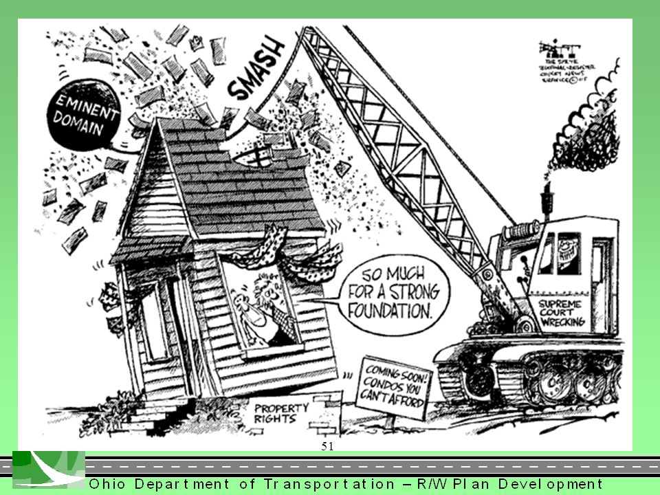
Your plan is the beginning of a complex process
Lets get it right for those who follow…. Your plan may someday be a Supreme Court case.

52
Doug Raters, P.E. Real Estate Administrator ODOT D-8 Lebanon grad- Univ. of Cincinnati, BS- Civil Engineering EIT program- ODOT Design Engineer in Dist.8 Real Estate Section Became Registered Professional Engineer- State of Ohio Became District 8 Real Estate Administrator Feb-2007: Completed 20th year with ODOT

53
ODOT’s Project Development Process PDP
Objectives 3 Project Levels Steps within the Levels Corresponding Right of Way Activities and Section 1400 Location and Design Manual

54
Project Development Process
Objectives: Increase communication among disciplines. Systematic documentation to eliminate duplication of efforts. Early participation from all disciplines. Better manage scope, schedule and budget. Improve plan quality.

55
PDP - Three Project Levels
Major Project Level Steps MIS, corridor type projects, complex design work, large amounts of ROW, New highway on new location. (Typically EIS, EA or higher level CE projects.) Minor Project Level – 10 Steps Bridge replacements, resurfacing (with drainage), and safety projects. Projects may include ROW, utility relocations. (Typically lower level CE’s.) Minimal Project Level – 5 Steps (No Right of Way plans involved) (Exempt projects)
 Minor Project Level – 10 Steps. Bridge replacements, resurfacing (with drainage), and safety projects. Projects may include ROW, utility relocations. (Typically lower level CE’s.) Minimal Project Level – 5 Steps. (No Right of Way plans involved) (Exempt projects)")
56
(PDP Process Major Project)
")
57
Section 1400 of L&D Manual

58
PDP Steps/Section 1400 of L&D Manual

59
PDP Steps/Section 1400 of L&D Manual
Obtain survey data and aerial mapping Develop new/existing alignments to avoid/minimize red flags. Research centerline of Right of Way

60
PDP Steps/Section 1400 of L&D Manual
Find existing centerline/R/W monuments Establish centerline of ex. Right of Way Evaluate access that may produce LL par. Determine conceptual construction limits. Obtain tax map/ownership data. Determine types/existing R/W limits Identify possible total takes and relocations. MAJOR MINOR

61
PDP Steps/Section 1400 of L&D Manual
Finalize construction limits. Determine proposed R/W lines, easement or deed, channel, temps, etc. Contact property owners for UG items Reevaluate total takes/relocations, etc. MAJOR MINOR

62
PDP Steps/Section 1400 of L&D Manual
Determine if MOT will require additional right of way. Identify removal items in prop. R/W. Refine const. limits. Conduct title and deed research. Determine: property line locations, proposed R/W lines, encroachments, and total take, commercial and residential relocations. MAJOR MINOR

63
PDP Steps/Section 1400 of L&D Manual
MAJOR MINOR

64
PDP Steps/Section 1400 of L&D Manual
MAJOR MINOR

65
Project Development Process— Scope of Services (SOS)
Pre-scope Meeting: ODOT District meeting with all pertinent internal personnel. Specifically define project scope using PDP. SOS Meeting: Includes consultants and subs. ALL ODOT disciplines. Redefine project requirements to finalize scope. Q & A and clarification. Project Schedule.

66
Sample Scope Document (Major)
")
67
Sample Scope Document (Major)
")
68
Sample Scope Document (Major)
")
69
Sample Scope Document (Major)
")
70
Sample Scope document (Major)
")
71
Sample Scope document (Major)
")
72
Sample Scope Document (Minor)
")
73
Sample Scope Document (Minor)
")
74
Right-of-Way issues not covered in the Manual (highlighted in BLACK)
RIGHT OF WAY ATTACHMENT EXTENT OF FIELD SURVEYS - ADDITIONAL REQUIREMENTS: Right of way lines and property lines shall be located based on requirements specified in Chapter of the Ohio Revised Administrative Code (Board Rules) governed by regulations outlined in Chapter 4733, Ohio Revised Code (Regulation Laws) and in accordance with any special requirements of the county(s) in which the project is located. All topographic features (refer to Section , of the Real Estate Policies and Procedures Manual) within 100 feet either side of the proposed right of way shall be accurately located and identified. Underground facilities, to include, but not limited to, storage tanks, septic tanks/systems, leach beds, utilities, including service lines in accordance with Section ORC) drain pipes and exposed field tiles shall be located and identified as to the size and type. The consultant shall complete and submit an RE-75 Utility Reporting Form to the District Production Administrator at the time of filing for LG & T approval. Special attention shall be given to any commercial/industrial property having underground storage tanks in current use or which may have previously utilized underground storage tanks, e.g. service stations, print shops, dry cleaners, etc., to identify any potential environmental concerns. The above described topographic features, utilities (See Utility Section, Scope of Services), underground facilities and special attention items shall be shown on the preliminary Right of Way plan submittal. ODOT’s Project Development Process Included as an attachment to every scope involving R/W is the Right-of-way attachment. Right-of-Way issues not covered in the Manual (highlighted in BLACK)
 governed by regulations outlined in Chapter 4733, Ohio Revised Code (Regulation Laws) and in accordance with any special requirements of the county(s) in which the project is located. All topographic features (refer to Section , of the Real Estate Policies and Procedures Manual) within 100 feet either side of the proposed right of way shall be accurately located and identified. Underground facilities, to include, but not limited to, storage tanks, septic tanks/systems, leach beds, utilities, including service lines in accordance with Section ORC) drain pipes and exposed field tiles shall be located and identified as to the size and type. The consultant shall complete and submit an RE-75 Utility Reporting Form to the District Production Administrator at the time of filing for LG & T approval. Special attention shall be given to any commercial/industrial property having underground storage tanks in current use or which may have previously utilized underground storage tanks, e.g. service stations, print shops, dry cleaners, etc., to identify any potential environmental concerns. The above described topographic features, utilities (See Utility Section, Scope of Services), underground facilities and special attention items shall be shown on the preliminary Right of Way plan submittal. ODOT’s Project Development Process. Included as an attachment to every scope involving R/W is the Right-of-way attachment. Right-of-Way issues not covered in the Manual (highlighted in BLACK)")
75
Right-of-Way issues not covered in the Manual
ODOT’s Project Development Process If authorized, staking/flagging of the proposed permanent/temporary Right of Way for appraisal/negotiation shall be done by the Consultant upon the request and instruction of the District Real Estate Administrator. The Consultant will then have ten (10) working days after the request to perform the work and certify, in writing, the work complete to the District. When performing this work, the consultant shall set wood hubs and lathe stakes every 250 feet and/or change in direction in the proposed Right of Way, marked with permanent marker, by station and type (WD, Temp, CH, etc.) with separate color flagging for each type. Included as an attachment to every scope involving R/W is the Right-of-way attachment. Right-of-Way issues not covered in the Manual
 working days after the request to perform the work and certify, in writing, the work complete to the District. When performing this work, the consultant shall set wood hubs and lathe stakes every 250 feet and/or change in direction in the proposed Right of Way, marked with permanent marker, by station and type (WD, Temp, CH, etc.) with separate color flagging for each type. Included as an attachment to every scope involving R/W is the Right-of-way attachment. Right-of-Way issues not covered in the Manual.")
76
Right-of-Way issues not covered in the Manual (highlighted in BLACK)
ODOT’s Project Development Process The consultant shall utilize property ownership data for Right of Way plan development based on a search of county records (See Title Report) conducted no more than six (6) months prior to the preliminary Right of Way plan submittal. The Consultant shall submit copies to the District Real Estate Office of each property owner’s record deed transferring title to that owner with the preliminary Right of Way plan (Stage 2 Review). In cases where partial title interest is conveyed, copies of any supplemental documents required to delineate property lines and title shall also be submitted. A report, if needed, identifying any title defects encountered for the affected parcels should be included with the deed copies. This submittal should also include all applicable tax maps and Auditor cards. In addition, no more than fifteen (15) days prior to submission of the final Right of Way tracings, the property ownership data shall be checked and verified. Copies of the deeds for any new ownership transactions that impact the project shall be submitted to the District Real Estate Office. An in-depth field review of the project should also be conducted within this fifteen (15) day period to assure that no topographic features; structures and/or utilities have been changed or omitted. The Right of Way plan and descriptions should be revised to accurately reflect the above information. The submittal letter should contain the actual dates that the ownership data and topography were checked and verified. The Consultant shall submit with the Final Right of Way review plan the Coordinate Geometry Data for all alignment(s) points and parcel corner points in a comma delimitated ASCII file format (Pt. No., North, East) along with a copy of the plan with the point numbers identified to the location they represent. After ODOT’s review and approval, the Consultant shall be responsible for obtaining the final approval of the centerline survey plat from the appropriate County official(s). The Consultant shall then be responsible for recording the approved centerline plat (including providing the recording fee) in the appropriate County(s) office. The approval and recording shall take place before the submission of the final Right of Way tracings. The original recording plat must then be submitted to the District with the final R/W tracings. Included as an attachment to every scope involving R/W is the Right-of-way attachment. Right-of-Way issues not covered in the Manual (highlighted in BLACK)
 conducted no more than six (6) months prior to the preliminary Right of Way plan submittal. The Consultant shall submit copies to the District Real Estate Office of each property owner’s record deed transferring title to that owner with the preliminary Right of Way plan (Stage 2 Review). In cases where partial title interest is conveyed, copies of any supplemental documents required to delineate property lines and title shall also be submitted. A report, if needed, identifying any title defects encountered for the affected parcels should be included with the deed copies. This submittal should also include all applicable tax maps and Auditor cards. In addition, no more than fifteen (15) days prior to submission of the final Right of Way tracings, the property ownership data shall be checked and verified. Copies of the deeds for any new ownership transactions that impact the project shall be submitted to the District Real Estate Office. An in-depth field review of the project should also be conducted within this fifteen (15) day period to assure that no topographic features; structures and/or utilities have been changed or omitted. The Right of Way plan and descriptions should be revised to accurately reflect the above information. The submittal letter should contain the actual dates that the ownership data and topography were checked and verified. The Consultant shall submit with the Final Right of Way review plan the Coordinate Geometry Data for all alignment(s) points and parcel corner points in a comma delimitated ASCII file format (Pt. No., North, East) along with a copy of the plan with the point numbers identified to the location they represent. After ODOT’s review and approval, the Consultant shall be responsible for obtaining the final approval of the centerline survey plat from the appropriate County official(s). The Consultant shall then be responsible for recording the approved centerline plat (including providing the recording fee) in the appropriate County(s) office. The approval and recording shall take place before the submission of the final Right of Way tracings. The original recording plat must then be submitted to the District with the final R/W tracings. Included as an attachment to every scope involving R/W is the Right-of-way attachment. Right-of-Way issues not covered in the Manual (highlighted in BLACK)")
77
John Messmore, P.S. ODOT District 4
John has been with ODOT for 6 years and this is the 6th year as a presenter for the Right of Way Pre-Qualification course. John obtain a B.S. in Surveying and Mapping from the University of Akron in He started his own surveying firm in 2000 and has been a part-time instructor of the surveying courses at the University of Akron.

78
Records Research - Section 3104
Existing Right of Way History of Ohio Roads County/Township Roads Inter County Highways (ICH) State Highways Deed Research/Investigation OAC Misc. Public Records Zoning Regulations If Scoped – ODOT Title Report What is it? Who can prepare? Who benefits? Are there limitations?
 State Highways. Deed Research/Investigation. OAC Misc. Public Records. Zoning Regulations. If Scoped – ODOT Title Report. What is it Who can prepare Who benefits Are there limitations")
79
Establishing Existing Road Right of Way
History of Ohio Roads Establishment Board of County Commissioners Statutory Dedication Common-Law Dedication Statutory Appropriation – Eminent Domain Prescriptive Easement – Similar to Adverse Possession (only easement rights pass) County and Township Roads Early Procedure for Road Establishment Land Holders Petition the County Commissioners County Commissioners made order for laying out road Currently governed by ORC 5533 This is a critical step to make sure you have ALL the information you need to establish existing R/W. Don’t assume you got all you needed from the scope of services meeting. Check your ODOT district office and local county Engineer for more plans.
 County and Township Roads. Early Procedure for Road Establishment. Land Holders Petition the County Commissioners. County Commissioners made order for laying out road. Currently governed by ORC This is a critical step to make sure you have ALL the information you need to establish existing R/W. Don’t assume you got all you needed from the scope of services meeting. Check your ODOT district office and local county Engineer for more plans.")
80
See Appendix C in the Manual for a complete list
GENERAL LAWS OF THE STATE OF OHIO RELATING TO THE WIDTH OF COUNTY ROADS Vol. II, page 210 It shall be the duty of said Commissioner to order the said road to be opened a necessary width, not exceeding sixty-six feet, and made in respects convenient for the passage of travelers and cause a record therefore to be made which thenceforth shall be deemed a public road. February 17, 1804 Vol. XIV, page 226 They (the Commissioners) shall order such road to be opened a necessary which not exceeding sixty feet and made in other respects convenient for the passage of travelers and carriages and cause a record thereof to be made, which road thenceforth shall be deemed a public highway. February 16, 1816 See Appendix C in the Manual for a complete list
 shall order such road to be opened a necessary which not exceeding sixty feet and made in other respects convenient for the passage of travelers and carriages and cause a record thereof to be made, which road thenceforth shall be deemed a public highway. February 16, See Appendix C in the Manual for a complete list.")
81
History of Ohio Roads (Continued)
Special circumstances to be aware of Roads were often built in sections rather than their entire length as might be indicated today (possibly creating different R/W widths) Road names change County Commissioners have the legal authority to change, alter and vacate roads Roads relocated but R/W never vacated This is a critical step to make sure you have ALL the information you need to establish existing R/W. Don’t assume you got all you needed from the scope of services meeting. Check your ODOT district office and local county Engineer for more plans.
 Road names change. County Commissioners have the legal authority to change, alter and vacate roads. Roads relocated but R/W never vacated. This is a critical step to make sure you have ALL the information you need to establish existing R/W. Don’t assume you got all you needed from the scope of services meeting. Check your ODOT district office and local county Engineer for more plans.")
82
History of Ohio Roads (Continued)
Inter County Highway System (I.C.H.) The Department of Highways was created in 1904, later became Ohio Department of Transportation. Object and purpose of the Department was to instruct, assist and co-operate in the building and improvement of PUBLIC ROADS. State Routes as we know them did not exist at this time In 1911 the State legislature created the Inter County Highway System(I.C.H.) All counties were required to create accurate roadway maps Maps were submitted to the State Highway Commissioner Highway Commissioner selected county roads that connected to adjoining county roads to create “as near as practicable continuous” Inter County Highway System This is a critical step to make sure you have ALL the information you need to establish existing R/W. Don’t assume you got all you needed from the scope of services meeting. Check your ODOT district office and local county Engineer for more plans.
 The Department of Highways was created in 1904, later became Ohio Department of Transportation. Object and purpose of the Department was to instruct, assist and co-operate in the building and improvement of PUBLIC ROADS. State Routes as we know them did not exist at this time. In 1911 the State legislature created the Inter County Highway System(I.C.H.) All counties were required to create accurate roadway maps. Maps were submitted to the State Highway Commissioner. Highway Commissioner selected county roads that connected to adjoining county roads to create as near as practicable continuous Inter County Highway System. This is a critical step to make sure you have ALL the information you need to establish existing R/W. Don’t assume you got all you needed from the scope of services meeting. Check your ODOT district office and local county Engineer for more plans.")
83
History of Ohio Roads (Continued)
Inter County Highway System (I.C.H.) Counties made improvements to the roads selected by the Highway Commissioner under the supervision of the Department of Highways State paid Counties for improvements, then took over maintenance and Right of Way of former County Roads County Commissioners certified to the State the width of the Right of Way. This information is usually on the cover sheet for the I.C.H. plans Some County Commissioners’ Journals will contain information from public meetings concerning I.C.H. Routes and the Right of Way obtained or verified by the County Surveyor/Engineer This is a critical step to make sure you have ALL the information you need to establish existing R/W. Don’t assume you got all you needed from the scope of services meeting. Check your ODOT district office and local county Engineer for more plans.
 Counties made improvements to the roads selected by the Highway Commissioner under the supervision of the Department of Highways. State paid Counties for improvements, then took over maintenance and Right of Way of former County Roads. County Commissioners certified to the State the width of the Right of Way. This information is usually on the cover sheet for the I.C.H. plans. Some County Commissioners’ Journals will contain information from public meetings concerning I.C.H. Routes and the Right of Way obtained or verified by the County Surveyor/Engineer. This is a critical step to make sure you have ALL the information you need to establish existing R/W. Don’t assume you got all you needed from the scope of services meeting. Check your ODOT district office and local county Engineer for more plans.")
84
We the commissioners of Wayne County hereby approve these plans and certify that the right-of-way 60 feet wide is available for the construction of the above road. This is a critical step to make sure you have ALL the information you need to establish existing R/W. Don’t assume you got all you needed from the scope of services meeting. Check your ODOT district office and local county Engineer for more plans.

85
History of Ohio Roads (Continued)
Other sources for establishing existing R/W limits and widths Existing Right of Way Plan (the latest) (may be a combination of several plans) Old Construction Plans (1940’s and earlier) R/W in plan Online Plats This is a critical step to make sure you have ALL the information you need to establish existing R/W. Don’t assume you got all you needed from the scope of services meeting. Check your ODOT district office and local county Engineer for more plans.
 (may be a combination of several plans) Old Construction Plans (1940’s and earlier) R/W in plan. Online Plats. This is a critical step to make sure you have ALL the information you need to establish existing R/W. Don’t assume you got all you needed from the scope of services meeting. Check your ODOT district office and local county Engineer for more plans.")
89
BRO (M) Year 2000
 Year 2000")
90
BRO (M) Year 2000 Area of S.R 62 from 1926 Plans
 Year 2000 Area of S.R 62 from 1926 Plans")
91
Deed Research/Investigation
OAC Current Ownership Deeds Check for full ownership, possibly more than one owner Quit Claim Deeds Court Documents / Clerk of Courts Recorded Easements Oil, Gas and Coal rights Utilities rights Ingress and Egress rights

92
Deed Research/Investigation (Continued)
Misc. Public Records Government Surveys Private surveys Recorded Subdivisions Tax Maps, Auditors Parcel Numbers Health Department (Septic Systems and Wells) ODNR Oil and Gas Well Logs
 ODNR Oil and Gas Well Logs.")
93
Deed Research/Investigation (Continued)
Zoning Information Local or County Zoning Boards Zoning Classification Set Back Information Some deeds may also contain restrictions on the property they describe Recorded Subdivision Plats often have restriction on the plat or recorded as a separate document Condominium and/or home owner associations restrictions This is a critical step to make sure you have ALL the information you need to establish existing R/W. Don’t assume you got all you needed from the scope of services meeting. Check your ODOT district office and local county Engineer for more plans.

94
ODOT Title Reports What is it?
The ODOT title report provides evidence supporting the ownership of the legal description being acquired for the highway project. This evidence is assembled in a title report and the documentation supporting this evidence is attached to the title report. The evidence supporting the interrelationship of ownership and legal description is inserted into the Title Report [form RE 46] and the Title Chain [form RE 46-1]. Also attached to these forms is the appropriate documentation (mortgages, easements, taxes, leases, mineral rights, liens and encumbrances) that supports what was stated by the title agent in the Title Report and Title Chain.
 that supports what was stated by the title agent in the Title Report and Title Chain.")
95
ODOT Title Reports (Continued)
Who Can Prepare? Consultants performing any type of title function must be pre qualified with the Ohio Department of Transportation: Go to: R/W Consultant Services List of Pre Qualified Consultants Title Reports must meet the requirements of Section 5100 of ODOT’s Real Estate Manual.

96
ODOT Title Reports (Continued)
What Are The Benefits? Accurate and updated ownership names. Verification of recorded easements, their location and effect on taking. Saves time at the beginning of acquisition process.

97
ODOT Title Reports (Continued)
What Are The Limitations? Root title (42 year) may not satisfy OAC Title for taking (parcel) only. May not include entire contiguous ownership. Permanent parcel number(s) given for takings (parcels) only. No determination if auditor’s area excludes P.R.O. Unrecorded easements not determined. Plat restrictions not identified.
 may not satisfy OAC Title for taking (parcel) only. May not include entire contiguous ownership. Permanent parcel number(s) given for takings (parcels) only. No determination if auditor’s area excludes P.R.O. Unrecorded easements not determined. Plat restrictions not identified.")
Similar presentations


 Grants Chapter 6.>")


