Download presentation
Presentation is loading. Please wait.

1
WHAT HAPPENS TO LATENT HEAT?

2
SINKS OF INSOLATION 1. SENSIBLE HEAT FLUX. Energy used in changing the temperature of the air.

3
SINKS OF INSOLATION 1. SENSIBLE HEAT FLUX. Energy used in changing the temperature of the air. 2. GROUND HEAT FLUX. Energy used in changing the temperature of the planet’s surface (continents and oceans)
")
4
SINKS OF INSOLATION 1. SENSIBLE HEAT FLUX. Energy used in changing the temperature of the air. 2. GROUND HEAT FLUX. Energy used in changing the temperature of the planet’s surface (continents and oceans). 3. LATENT HEAT FLUX. Energy used in changing the state of Water
. 3. LATENT HEAT FLUX. Energy used in changing the state of Water.")
5
WE NEED TO TRANSFER ENERGY

6
WE NEED TO TRANSFER ENERGY
1. SENSIBLE HEAT FLUX. Warm/cold air exchanges, global/seasonal wind patterns (ADVECTION)
")
7
WE NEED TO TRANSFER ENERGY
1. SENSIBLE HEAT FLUX. Warm/cold air exchanges, global/seasonal wind patterns (ADVECTION) 2. GROUND HEAT FLUX. Warm/cold surface water currents in oceans (2/3rd of global surface. (ADVECTION)
 2. GROUND HEAT FLUX. Warm/cold surface water currents in oceans (2/3rd of global surface. (ADVECTION)")
8
WE NEED TO TRANSFER ENERGY
1. SENSIBLE HEAT FLUX. Warm/cold air exchanges, global/seasonal wind patterns (ADVECTION) 2. GROUND HEAT FLUX. Warm/cold surface water currents in oceans (2/3rd of glabal surface. (ADVECTION) 3. LATENT HEAT FLUX. Change of state of water - vapor, liquid, solid (Condensation/Evaporation; Freezing/Thawing) …. Precipitation (rain/snow)
 2. GROUND HEAT FLUX. Warm/cold surface water currents in oceans (2/3rd of glabal surface. (ADVECTION) 3. LATENT HEAT FLUX. Change of state of water - vapor, liquid, solid (Condensation/Evaporation; Freezing/Thawing) …. Precipitation (rain/snow)")
9
TRANSFER OF LATENT HEAT
Formation of rain and snow redistributes latent heat from point where evaporation took place (Input of latent heat of fusion and latent heat of vaporization). To the place where cloud formation and precipitation occurs (release of latent heat to the environment).
. To the place where cloud formation and precipitation occurs (release of latent heat to the environment).")
10
HOW TO EXTRACT LATENT HEAT FROM WATER VAPOR.
Cool the air!

11
HOW TO EXTRACT LATENT HEAT FROM WATER VAPOR.
Cool the air! “Warm air can hold more moisture than cold air.”

12
HOW TO EXTRACT LATENT HEAT FROM WATER VAPOR.
Cool the air! “Warm air can hold more moisture than cold air.” Clausius-Clapeyron relationship

13
HOT FLORIDA AND AIR CONDITIONER!

14
HOT FLORIDA AND AIR CONDITIONER!

15
Decline in Temperature

16
Decline in Temperature (20°F) Decline in Moisture As Vapor (18 g.km-1)
 Decline in Moisture As Vapor (18 g.km-1)")
17
Decline in Temperature (20°F) Decline in Moisture As Vapor (18 g.km-1)
 Decline in Moisture As Vapor (18 g.km-1)")
18
ENGLAND! Decline in Temperature (20°F) Decline in Moisture As Vapor
(10 g.km-1)
")
19
ENGLAND! Decline in Temperature (20°F) Decline in Moisture As Vapor
(10 g.km-1)
")
20
TOO COLD TO SNOW? Decline in Temperature (20°F) Decline in Moisture
As Vapor (1 g.km-1)
")
21
TOO COLD TO SNOW? Decline in Temperature (20°F) Saskatchewan
Moisture As Vapor (1 g.km-1)
")
22
PUT ON THE FURNACE! 20 below!

23
Very, very low Moisture content

24
Warm to 70°F in the furnace

25
Can now hold more moisture

26
Moisture Deficit (19 g. km-1)
")
27
Moisture Deficit (19 g. km-1)
")
28
GLOBAL AIR CONDITIONERS???

29
GLOBAL AIR CONDITIONERS???
Q. How to make air cooler?

30
GLOBAL AIR CONDITIONERS???
Q. How to make air cooler? Make it rise in the atmosphere and it will Cool at the lapse rate! (Equation of state of an ideal gas!) Lapse rate = ~6.4°C/km
 Lapse rate = ~6.4°C/km.")
31
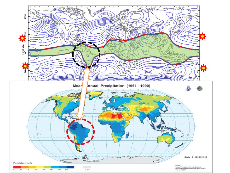
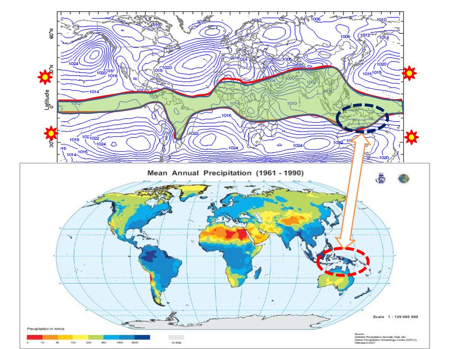
WHERE IN THE WORLD IS THE AIR RISING (AND COOLING)?
That is where we will get condensation clouds and precipitation.

32
WHERE IN THE WORLD IS THE AIR RISING (AND COOLING)?
That is where we will get condensation clouds and precipitation. GLOBAL CIRCULATION PATTERNS – WHERE IS AIR RISING IN TROPOSPHERE?

33
1. Above the migrating equatorial Low pressure.
Inter-tropical Convergence Zone HIGH 45-60°N LOW LOW 30°N HIGH HIGH HIGH Tropopause 0° LOW LOW LOW 30°S HIGH HIGH HIGH LOW LOW 45-60°S HIGH

34
June December

39
2. Above the Low pressure zones at 45-60°.
HIGH 45-60°N LOW LOW 30°N HIGH HIGH HIGH 2. Above the Low pressure zones at 45-60°. Planetary Front Tropopause 0° LOW LOW LOW 30°S HIGH HIGH HIGH LOW LOW 45-60°S HIGH

40
MID-LATITUDE~ PLANETARY FRONT. And Seasonal Migration.

41
GLOBAL FURNACES???

42
GLOBAL FURNACES??? Q. How to make air warmer?

43
GLOBAL FURNACES??? Q. How to make air warmer?
Make it descend in the atmosphere and it will cool at the lapse rate! (Equation of state of an ideal gas!) Lapse rate = ~6.4°C/km
 Lapse rate = ~6.4°C/km.")
44
WHERE IN THE WORLD IS THE AIR DESCENDING (AND WARMING)?
That is where we will get evaporation, clear skies and deserts.

45
WHERE IN THE WORLD IS THE AIR DESCENDING (AND WARMING)?
That is where we will get condensation clouds and precipitation. GLOBAL CIRCULATION PATTERNS – WHERE IS AIR DESCENDING IN TROPOSPHERE?

46
1. Above the High pressure zones at 30°.
LOW LOW 30°N HIGH HIGH HIGH 1. Above the High pressure zones at 30°. Sub-tropical anticyclones Tropopause 0° LOW LOW LOW 30°S HIGH HIGH HIGH LOW LOW 45-60°S HIGH

47
SUB-TROPICAL HIGH PRESSURE

48
SUB-TROPICAL HIGH PRESSURE
Mojave

49
SUB-TROPICAL HIGH PRESSURE
Sahara

50
SUB-TROPICAL HIGH PRESSURE
Middle East

51
SUB-TROPICAL HIGH PRESSURE
Gobi

52
SUB-TROPICAL HIGH PRESSURE
Atacama

53
SUB-TROPICAL HIGH PRESSURE
Kalahari

54
SUB-TROPICAL HIGH PRESSURE
Great Australian

55
Fig. 2 The zonal height structure over ocean of observed climatological annual mean RH from AIRS (2002–2007) (color scale), with model mean projected changes in cloud amount from the CMIP3 model archive (contour lines, 0.5% intervals, dashed for cloud loss). Troposhere The zonal height structure over ocean of observed climatological annual mean RH from AIRS (2002–2007) (color scale), with model mean projected changes in cloud amount from the CMIP3 model archive (contour lines, 0.5% intervals, dashed for cloud loss). The cloud loss in a warming climate at about 40°N/S coincides with broadening of the dry zones, as indicated by the arrows. J T Fasullo, K E Trenberth Science 2012;338: Published by AAAS
 (color scale), with model mean projected changes in cloud amount from the CMIP3 model archive (contour lines, 0.5% intervals, dashed for cloud loss). The cloud loss in a warming climate at about 40°N/S coincides with broadening of the dry zones, as indicated by the arrows. J T Fasullo, K E Trenberth Science 2012;338: Published by AAAS.")
56
Fig. 3 (A) Median change in simulated top-of-atmosphere net shortwave flux as a function of latitude under 21st-century warming in CMIP3 SRES A1B projections.
 Median change in simulated top-of-atmosphere net shortwave flux as a function of latitude under 21st-century warming in CMIP3 SRES A1B projections..")
57
2. Above the Polar High pressure zones. Polar “deserts” Tropopause
LOW LOW 30°N HIGH HIGH HIGH 2. Above the Polar High pressure zones. Polar “deserts” Tropopause 0° LOW LOW LOW 30°S HIGH HIGH HIGH LOW LOW 45-60°S HIGH

58
BOREAL POLAR “DESERTS”

59
Estimate Annual Precipitation Antarctica
mm 2” 4” 6” 8” 10” 12” Gainesville 48”

60
GLOBAL AIR CONDITIONERS II ???
Q. How to make air cooler?

61
GLOBAL AIR CONDITIONERS???
Q. How to make air cooler? Make it rise by putting a barrier across the path that the surface global winds want to travel. Orographic Precipitation

62
CENTRAL AIR (Heating and Cooling)!!
!!")
63
CENTRAL AIR (Heating and Cooling)!!
Ocean Continent

64
CENTRAL AIR (Heating and Cooling)!!
Pressure Gradient HIGH LOW

65
CENTRAL AIR (Heating and Cooling)!!
Pressure Gradient HIGH Saturated Air LOW

66
CENTRAL AIR (Heating and Cooling)!!
Pressure Gradient Forced to rise and cool over mountain chain HIGH LOW

67
CENTRAL AIR (Heating and Cooling)!!
Pressure Gradient HIGH LOW AIR CONDITIONER! Clouds and heavy precipitation. May be snow

68
CENTRAL AIR (Heating and Cooling)!!
Pressure Gradient Descending air, warming, able to hold more moisture HIGH LOW AIR CONDITIONER! Clouds and heavy precipitation. May be snow FURNACE! Dry, evaporation, clear skies

69
CENTRAL AIR (Heating and Cooling)!!
Pressure Gradient W. Washington Temperate Rainforest E. Washington Near desert Irrigation HIGH LOW

70
WASHINGTON STATE LOW 45-60°N 49°N 49°N HIGH 30°N Cascade Mountains
Olympia Range Olympia Range Cascade Mountains HIGH 30°N

71
WASHINGTON STATE LOW 45-60°N 49°N 49°N HIGH 30°N

72
WASHINGTON STATE LOW 45-60°N 49°N 49°N HIGH 30°N

73
WASHINGTON STATE WINDWARD LEEWARD RAINSHADOW LOW 45-60°N 49°N 49°N
HIGH 30°N

74
PERU ANDES

75
PERU LOW 0° LOW 0° ANDES HIGH 30°S HIGH 30°S

76
PERU LOW 0° LOW 0° HIGH 30°S HIGH 30°S

77
PERU LOW 0° LOW 0° Southeast Trades HIGH 30°S HIGH 30°S

78
PERU LOW 0° LOW 0° HIGH 30°S HIGH 30°S Sechura Desert “Furnace”
Leeward Rainshdow HIGH 30°S HIGH 30°S

79
PERU LOW 0° LOW 0° HIGH 30°S HIGH 30°S Eastern Andes Sechura Desert
“Air Conditioner” Windward Amazon headwaters Sechura Desert “Furnace” HIGH 30°S HIGH 30°S

80
Annual Precipitation Annual Sunshine Topography 2.5 hrs/day

81
WHAT ABOUT FLORIDA?

82
20 – 30° GLOBAL DESERTS! HELLO!
30°N

83
North Atlantic Anti-cyclone and Gyr

84
North Atlantic Anti-cyclone and Gyr
Warm Current (Gulf Stream) Cold Current (Canary) H
 Cold. Current. (Canary) H.")
85
North Atlantic Anti-cyclone and Gyr
Warmer Moist Air Cooler Air H

86
FLORIDA Gulf of Mexico North Atlantic

87
FLORIDA Gulf of Mexico North Atlantic WARM MOIST TROPICAL AIR

88
FLORIDA Gulf of Mexico North Atlantic WARM MOIST TROPICAL AIR

89
FLORIDA Gulf of Mexico North Atlantic
ZONE OF EXCESS ENERGY (26-30°N) – Land warms faster than sea
 – Land warms faster than sea.")
90
90°F FLORIDA Gulf of Mexico North Atlantic
30 ppt H2O 80°F 30 ppt H2O 90°F FLORIDA Gulf of Mexico North Atlantic ZONE OF EXCESS ENERGY (26-30°N) – Land warms faster than sea
 – Land warms faster than sea.")
91
90°F FLORIDA Gulf of Mexico North Atlantic
Warmer Air (90°F) Rises 80°F 30 ppt H2O 80°F 30 ppt H2O 90°F FLORIDA Gulf of Mexico North Atlantic ZONE OF EXCESS ENERGY (26-30°N) – Land warms faster than sea
 Rises. 80°F. 30 ppt. H2O. 80°F. 30 ppt. H2O. 90°F. FLORIDA. Gulf of Mexico. North Atlantic. ZONE OF EXCESS ENERGY (26-30°N) – Land warms faster than sea.")
92
90°F FLORIDA Gulf of Mexico North Atlantic
Warmer Air (90°F) Rises 80°F 30 ppt H2O 80°F 30 ppt H2O 90°F Moist Sea Breeze Moist Sea Breeze FLORIDA Gulf of Mexico North Atlantic ZONE OF EXCESS ENERGY (26-30°N) – Land warms faster than sea
 Rises. 80°F. 30 ppt. H2O. 80°F. 30 ppt. H2O. 90°F. Moist Sea Breeze. Moist Sea Breeze. FLORIDA. Gulf of Mexico. North Atlantic. ZONE OF EXCESS ENERGY (26-30°N) – Land warms faster than sea.")
93
90°F FLORIDA Gulf of Mexico North Atlantic
Temps decline as air rises – Lapse Rate 80°F 30 ppt H2O 80°F 30 ppt H2O 90°F Moist Sea Breeze Moist Sea Breeze FLORIDA Gulf of Mexico North Atlantic ZONE OF EXCESS ENERGY (26-30°N) – Land warms faster than sea
 – Land warms faster than sea.")
94
90°F FLORIDA Gulf of Mexico North Atlantic
10 ppt H2O 5km up Max Moisture Content Declines - Condensation 80°F 30 ppt H2O 80°F 30 ppt H2O 90°F Moist Sea Breeze Moist Sea Breeze FLORIDA Gulf of Mexico North Atlantic ZONE OF EXCESS ENERGY (26-30°N) – Land warms faster than sea
 – Land warms faster than sea.")
95
90°F FLORIDA Gulf of Mexico North Atlantic
Condensation releases latent heat vaporization. Warms air – Rises even more, etc. etc. 50°F 10 ppt H2O 5km up 80°F 30 ppt H2O 80°F 30 ppt H2O 90°F Moist Sea Breeze Moist Sea Breeze FLORIDA Gulf of Mexico North Atlantic ZONE OF EXCESS ENERGY (26-30°N) – Land warms faster than sea
 – Land warms faster than sea.")
96
90°F FLORIDA Gulf of Mexico North Atlantic CONVECTION
30 ppt H2O 80°F 30 ppt H2O 90°F Moist Sea Breeze Moist Sea Breeze FLORIDA Gulf of Mexico North Atlantic ZONE OF EXCESS ENERGY (26-30°N) – Land warms faster than sea
 – Land warms faster than sea.")
97
FLORIDA AND S.E. NOT UNIQUE
Gulf Stream Kuro Siwo Mozambique Current E. Australian Current Brazil Current

98
SAME PRINCIPLE – DIFFERENT LATITUDE!
Alaska Current Gulf Stream ?

99
WHY NOT CALIFORNIA?

100
CALIFORNIA North Pacific Cold California Current
10 ppt H2O 5km up 60°F 15 ppt H2 Sea Breeze CALIFORNIA North Pacific ZONE OF EXCESS ENERGY (26-30°N) – Land warms faster than sea
 – Land warms faster than sea.")
101
COLD CURRENT + ANTICYCLONE = DESERT (Big time!)
California Current Canary Current Humboldt Current Benguela Current W. Australian Current

Similar presentations