Download presentation
Presentation is loading. Please wait.

1
Coastal Processes

2
Lesson 1 Lesson aims: What is the coast?
What is meant by a coastal system? What are the inputs, processes and outputs of a coastal system?

3
Key Question 1: What is a coastal system and what are the dynamics of coastal environments? The Coastal System The coast is the interface between land and sea. One way to study the coast is to view it as a system. The coast is an open system. Energy inputs from waves drive the system.

4
From time to time the energy input is boosted by storm surges and tidal waves.
A small proportion of the sediment is provided from within the system by wave erosion of cliffs. Weathering also contributes; cliff faces above the high water mark are affected and any loose materials broken off either fall or are carried within reach of the waves by different types of mass movement. The evidence for this interaction are the processes of erosion, transport and deposition. These processes give rise to the system’s main output: coastal landforms such as cliffs, beaches and salt marshes.

5
What is a system? It is where a set of components or variables operate together. They interact with one another. These are the processes. Patterns and landforms results from the interactions And can be observed and classified. These are the outputs. Coastal system Inputs Processes Outputs Energy Erosion Coastal landforms of erosion and deposition Sediment Transport Deposition Accumulations above the tidal limit

6
Lesson 2 Lesson aims: What is longshore drift?
What is meant by swash and backwash? What are coastal sediment cells? The names of the coastal sediment cells in the UK.

7
Longshore drift Where waves approach the coastline at an angle, when they break their swash pushes beach material up the beach at the same angle. The backwash then drags the material down the beach perpendicular (at a 90º angle) to the shore, following the line of the steepest gradient. This produces a zig-zag movement of sediment along the beach known as longshore drift. The action of waves constantly moves and sorts different sized material beach material..The action of longshore drift sorts beach material, due to the amount of energy required to move sediments. Larger particles will need more energy and therefore move at a slower pace. Largest beach sediment is found updrift, and the smallest material, which is more easily moved, downdrift.
 to the shore, following the line of the steepest gradient. This produces a zig-zag movement of sediment along the beach known as longshore drift. The action of waves constantly moves and sorts different sized material beach material..The action of longshore drift sorts beach material, due to the amount of energy required to move sediments. Larger particles will need more energy and therefore move at a slower pace. Largest beach sediment is found updrift, and the smallest material, which is more easily moved, downdrift.")
8
Coastal Sediment Cells
Longshoredrift is responsible for most of the interaction within the system through transfers of sediment. Loose materials are relocated within the system through transfers of sediment. Loose materials are relocated from sections of coastline dominated by erosion to those where deposition occurs to form constructive landforms such as beaches, spits and bars. Winds can carry sand inland as an output from the coastal system. Deposited coastal sediments that remain in position for a considerable length of time are colonised by seral communities as part of a plant succession.

9
Questions Describe and explain longshore drift.
Draw a sketch of the longshore drift process. What is swash? What is backwash? What are coastal sediment cells? Name the coasts that join the sediment cells in the UK. You could set it out like this… From To

10
Equilibrium beach profile
Energy input (swash) equals energy output (backwash): no net sediment transport Anticyclone conditions – reduction in wave energy As beach profile steepens, backwash strength increases Low energy surging breakers give a net onshore movement of sediment Beach profile steepens
 equals energy output (backwash): no net sediment transport. Anticyclone conditions – reduction in wave energy. As beach profile steepens, backwash strength increases. Low energy surging breakers give a net onshore movement of sediment. Beach profile steepens.")
11
Lesson 3: Wave types and characteristics
What are the characteristics of waves? How are they formed? What is swash/backwash? What are destructive waves? What are constructive waves?

12
Wave types Waves are undulations of the water surface caused by winds blowing across the sea. They consist of orbital movements of water molecules which diminish with depth. The circular motion of waves at the surface is copied below in a series of circles which become smaller with increasing depth. Shallow water interferes with the circular movements below the surface, which are slowed down by the friction of the sea bed. The result is that the length of the wave shortens and the front of the wave steepens. The speed of flow of water at the top of the wave begins to exceed that of the rest of the wave below so it topples over and the wave breaks.

13
What determines wave type?
Fetch, wind direction and wind strength are the main factors determining the height and energy of breaking waves. Fetch is the distance of uninterrupted water surface over which the wind has blown to form the waves. The longer the length of open water over which the winds travel, the longer the fetch and the greater the amount of energy released when waves break in the coastal zone.

14
How do waves form? The great majority of large breakers one sees on an ocean beach result from distant winds. Four factors influence the formation of wind waves: wind speed, distance of open water that the wind has blown over — called fetch, time duration the wind has blown over a given area, water depth.

15
Wave Characteristics Wavelength (L) is the average distance between successive wave crests. Wave height (H) is the vertical distance between a wave trough and a wave crest. Wave steepness is the ratio of wave height to wavelength. Powerful waves are steep because they are high and have short wavelengths. The energy in a wave is equal to the square of its height. Thus a wave that is two metres high contains four times as much energy as a one-metre high wave.
 is the vertical distance between a wave trough and a wave crest. Wave steepness is the ratio of wave height to wavelength. Powerful waves are steep because they are high and have short wavelengths. The energy in a wave is equal to the square of its height. Thus a wave that is two metres high contains four times as much energy as a one-metre high wave.")
16
Lesson 4: Lesson aims Classifying waves (learning the two types of wave) Destructive and Constructive waves and their resultant beach profiles. Tides and how they affect the coastline compared to waves. Coastal winds in Britain.

17
How do waves form? The great majority of large breakers one sees on an ocean beach result from distant winds. Four factors influence the formation of wind waves: wind speed, distance of open water that the wind has blown over — called fetch, time duration the wind has blown over a given area, water depth.

18
Classifying waves A common classification for waves is into destructive (plunging breakers) and constructive (spilling breakers), although not all waves are as easy to distinguish as this simple classification suggests Destructive waves: Constructive waves: operate in storm conditions are created from big, strong waves when the wind is strong and has been blowing for a long time occur when wave energy is high and the wave has travelled for a long time tend to remove material from the coast and associated with erosion backwash is stronger than the swash. Destructive waves create a steep narrow beach operate in calm weather are less powerful waves break on the shore and tend to deposit material, building up beaches are responsible for transporting material . swash is stronger than the backwash. Constructive waves create a wide, gently sloping beach.
 and constructive (spilling breakers), although not all waves are as easy to distinguish as this simple classification suggests. Destructive waves: Constructive waves: operate in storm conditions. are created from big, strong waves when the wind is strong and has been blowing for a long time. occur when wave energy is high and the wave has travelled for a long time. tend to remove material from the coast and associated with erosion. backwash is stronger than the swash. Destructive waves create a steep narrow beach. operate in calm weather. are less powerful waves. break on the shore and tend to deposit material, building up beaches. are responsible for transporting material . swash is stronger than the backwash. Constructive waves create a wide, gently sloping beach.")
19
A destructive wave All the energy accumulated by movement is released when the wave breaks. Since destructive waves are high and short, there is a sudden impact of water upon whatever the breaking wave hits. These waves are sufficiently high for the water motion to be almost circular so that the great force of water is directed downwards when they break. This gives a strong backwash, which increases the likelihood of loose material being clawed back down the beach into the sea. The rapid sequence of breaking waves under storm conditions means that the new swash is running into the backwash from the next breaker, reducing further any chance of sediment deposition.

20
A constructive wave In contrast, the more elliptical shape of water movement in a constructive wave means that the forward movement of the breaking wave is more pronounced than its downward force. By breaking forwards a strong swash is pushed up the beach, while the energy of the backwash is reduced as water seeps into the sand and shingle. Not all the loads is carried back to the sea. This promotes deposition.

21
Lesson 5: Coastal winds in Britain
What are prevailing winds, where do they occur around the UK? What are dominant winds, where do they occur around the UK? Direction of longshore drift around the British Isles. Factors leading to the creation of storm surges High and low energy coasts in the British Isles

22
British coastal winds Strong winds are one of the characteristics of the British Climate, because it lies in the zone dominated by low pressure and frontal depressions within the general world circulation. There is a high incidence of storm and gale force winds all down the western side of the British Isles. Storm waves generated by strong winds travel fast and follow in rapid succession, which contribute to their highly destructive nature.

23
Fetch in the British Isles
The maximum fetch in the British Isles is for Westerly winds blowing onshore on the west coast after an Atlantic crossing. Their fetch is longer than that can be reached by northerly or north-easterly winds in more enclosed seas like the North Sea. The westerly winds are also the prevailing winds, the winds that blow with greatest frequency. Where fetch is large, as along the west coast, the factors that control the height of breaking waves are wind strength and length of time it has been blowing at that strength.

24
What about the east coast?
The strong westerly winds cannot create damaging waves along the east coast of Britain because they are blowing offshore. Dominant winds (winds that produce the largest waves along a coast) are more significant here. The most damaging waves that affect eastern Scotland and England are driven by winds from the east and the north. Being dominant as opposed to prevailing means that they exert control over wave size on a smaller number of occasions during the year.
 are more significant here. The most damaging waves that affect eastern Scotland and England are driven by winds from the east and the north. Being dominant as opposed to prevailing means that they exert control over wave size on a smaller number of occasions during the year.")
25
Dominant winds There is no land on the direct northerly route from east Anglia to the North Pole to interrupt movement; therefore northerly winds originating in the Arctic ocean can drive waves onto the exposed north coast of Norfolk with the second longest fetch in the British Isles. In extreme circumstance, these produce tidal storm surges, which are short-term increases in sea level. They can be responsible for considerable changes to the coastline and great damage to property

26
Direction of longshore drift in the UK

27
Tides Tides have a more regular energy input into the coastal system than do waves. Tidal fluctuations depend upon the positions of the moon and sun. Tides can be forecast and are not an unpredictable input into the coastal system in the way that wind strength and wave size are. However, for the low-lying coastal regions spring tides are a worry, but their time and height can be forecast and precautions taken.

28
What are high and low energy coasts?
High energy coasts are ones in which wave power is strong for a significant proportion of the year. The distribution of these coasts is largely controlled by the climate and direction they face. Strong winds capable of generating the largest waves are more frequent in areas of the world with a Cool Temperate Western Maritime climate (CTWM). High average wind speeds are associated with the frontal depressions which form over the oceans at the junction between warm tropical and cold polar air masses. Exposed coastlines often experience gales, storm force winds regularly and hurricane force winds from time to time. The storm wave environments found in areas with CTWM climates are shown below. They occupy similar positions on the western side of the continents between 45 and 65 degrees north and south of the equator. Wave height and energy are greater in the southern hemisphere as westerly winds, depressions and ocean currents (the Antarctic drift) have uninterrupted passages around the globe as so little land extends south of 45 degrees, Waves hitting Chile often have the world’s longest fetches.
. High average wind speeds are associated with the frontal depressions which form over the oceans at the junction between warm tropical and cold polar air masses. Exposed coastlines often experience gales, storm force winds regularly and hurricane force winds from time to time. The storm wave environments found in areas with CTWM climates are shown below. They occupy similar positions on the western side of the continents between 45 and 65 degrees north and south of the equator. Wave height and energy are greater in the southern hemisphere as westerly winds, depressions and ocean currents (the Antarctic drift) have uninterrupted passages around the globe as so little land extends south of 45 degrees, Waves hitting Chile often have the world’s longest fetches.")
29
High and low energy coasts in the UK.
Within the UK, the west coast is a higher energy coast than the east coast. Westerly is the direction of both prevailing and dominant wind direction; it is also the direction of longest fetch. Maximum wave heights decrease from west to east and from north to south across the British Isles away from exposure to the open ocean and onshore westerly winds. Fetch is the limiting factor for the height of waves generated by easterly winds in the North Sea. No matter how long an easterly gale blows, the waves breaking against the eats coast can never reach the height of those from westerly gales along the west coast. However, with waves of fifteen and more meters in height occasionally recorded along the coast of Holderness, waves still have the power to cause considerable erosion.

30
Wave energy differences on a smaller scale
On a smaller scale some estuaries, inlets and bays provide more sheltered environments in which the average wave energy is lower than on the headlands and the more exposed coastal zones are on both sides of them. A change in coastal direction can also reduce average energy levels. Along coastlines that are irregular, waves approaching the headland feel the effects of frictional drag at their base before those which approach the bay. Waves around the headland turn inwards and concentrate their attack on them. This bending of the waves around a headland so that they approach almost parallel to the coast is called wave refraction. On the other hand, waves in the bays spread outwards and dissipate their energy. Differences in wave energy levels are thereby created at a local scale.

31
QUESTIONS: What is meant by high energy coastlines?
What is wave refraction? How can this affect wave energy? 4. Explain why ; i) the British Isles is an area of the world associated with high energy coasts ii) coasts with the highest energy are located on the western sides of the British Isles.
 the British Isles is an area of the world associated with high energy coasts. ii) coasts with the highest energy are located on the western sides of the British Isles.")
32
Mean percentage frequency of winds in the British Isles
Questions Distinguish between prevailing and dominant winds Draw a wind rose to show these percentages On an outline map of the British Isles, use annotations to outline the effects of relative frequencies in wind direction upon coastal processes around the British Isles. Figure 1 shows longshore drift and general directions of movement around Britain. Explain what Figure 1 shows in relation to prevailing and dominant winds. Why are tides considered to be less important than waves in the formation of coastal landforms? 6. Why do extreme events such as storm surges, only occur when a combination of factors favourable to their formation are present? 7. Explain why ; i) the British Isles is an area of the world associated with high energy coasts ii) coasts with the highest energy are located on the western sides of the British Isles. Mean percentage frequency of winds in the British Isles N NNE ENE E ESE SSE S SSW WSW W WNW NNW 7 5 6 8 9 14 15
 the British Isles is an area of the world associated with high energy coasts. ii) coasts with the highest energy are located on the western sides of the British Isles. Mean percentage frequency of winds in the British Isles. N. NNE. ENE. E. ESE. SSE. S. SSW. WSW. W. WNW. NNW")
33
Lesson 6:

34
Dynamic equilibrium in the coastal system
The concept of dynamic equilibrium is central to our understanding of natural systems. A system is in dynamic equilibrium when its inputs and outputs of energy and matter balance. In these circumstances, a system remains in steady state for long periods of time. Of course, short-term changes will still occur. Systems adjust to these changes by a process of negative feedback. Short-term event such as storms, greatly increase energy inputs to the coastal system. This starts the movement of sand and sediment transport comes to an end. At this stage the beach is at equilibrium – as long as wave conditions stay the same the basic beach form remains unaltered. Landforms such as beaches can adjust to changing energy inputs in just a few hours. In contrast, hard rock landforms, such as cliffs, may take thousands of years to achieve equilibrium. Today’s sea-level, and therefore the position of the coastline is only 6,000 years old. This means that large parts of the coastline have not had sufficient time to achieve equilibrium. We notice this by events such as rockfalls and landslides which can dramatically alter the coastline.

35
Why do some coastlines erode away? Why do some grow?
All beaches exist in a dynamic equilibrium involving four factors: The supply of sand The energy of the waves Changes in sea-level The location of the shoreline It is the balance of these four factors and how they interact with each other that determines whether a beach erodes or grows.

36
The concept of equilibrium
Coasts are dynamic and they change frequently. These changes are principally caused by changes in energy conditions such as wave energy e.g. Which may increase during storms. The morphology of the coast responds to changes in energy because it aims to exist in a state of equilibrium with the reigning processes. However, there are three types of equilibrium. 3. Steady state equilibrium. This refers to a situation where variations in energy and the morphological response do not deviate too far from the long-term average. E.g. Along a coast that experiences relatively consistent wave energy conditions, the gradient of a beach may be steeper at certain times of the year and shallower at others but the average annual gradient is similar from year to year. 2. Meta-stable equilibrium This exists where an environment switches from two or more states of equilibrium the switch stimulates by some sort of trigger. An example of this includes the action of high energy events such as storms/tsunamis. Which can very rapidly switch a coastal system from one state of equilibrium to another by removing or supplying large volumes of beach sediment for example. Also, human activity often has this effect on coastal environments. 3. Dynamic equilibrium Like meta stable equilibrium, this too involves a change in equilibrium conditions but in a much more gradual manner. A good example is the response of coasts to the gradual rise in sea levels that were experienced through the twentieth century as a result of climate change.

37
Swash and backwash When a wave breaks, water is washed up the beach: this is called the swash. Then the water runs back down the beach: this is called the backwash. With a constructive wave, the swash is stronger than the backwash. With a destructive wave, the backwash is stronger than the swash. Simple summary: Large waves erodeand very small waves deposit.

38
Lesson 7: Key question 2: What are the processes of coastal erosion and what are the resultant landforms? What are the processes of coastal erosion? What are the factors affecting the rates of erosion along a section of coastline?

39
So what’s the difference between Weathering and Erosion?
Weathering is the breaking down of rock into smaller and smaller particles. Weathering processes include frost wedging, acid rain dissolution, root growth, wind particle abrasion, heat expansion cracking, hydraulic fracture, and rock tumbling in rivers and streams. Erosion is the movement of weathered material from one place to another place through the agents of erosion: wind, water, ice, and gravity. In tandem, weathering and erosion act to lower the high points, and raise the low points on the surface of the planet.

40
Sub aerial processes This literally means ‘those occurring at the base of the atmosphere’. The effects of non-marine processes in the coast zone can be observed most clearly on cliff tops. The influence of sub-aerial processes such as mass movement and weathering is particularly evident on incoherent rocks. Heavy rainfall is the trigger for many movements. In the UK most cliff tops are vegetation covered which delays but does not stop mass movements.

41
Processes of weathering
Weathering is the decomposition of earth rocks, soils and their minerals through direct contact with the planet's atmosphere. Rocks gradually wear away. This is called weathering. There are three types of weathering: physical weathering chemical weathering biological weathering Physical weathering This is caused by physical changes such as changes in temperature, freezing and thawing, and the effects of wind, rain and waves. Temperature changes When a rock gets hot it expands a little, and when a rock gets cold it contracts a little. If a rock is heated and cooled many times, cracks form and pieces of rock fall away. This type of physical weathering happens a lot in deserts, because it is very hot during the day but very cold at night. Freeze-thaw Water expands slightly when it freezes into ice. This is why water pipes sometimes burst in the winter. You might have seen a demonstration of this sort of thing at school - a jar filled to the brim with water eventually shatters after it is put into a freezer. Biological weathering Animals and plants can wear away rocks. This is called biological weathering. For example, burrowing animals such as rabbits can burrow into a crack in a rock, making it bigger and splitting the rock. Chemical weathering Rainwater is naturally slightly acidic because carbon dioxide from the air dissolves in it. Minerals in rocks may react with the rainwater, causing the rock to be weathered. The weathering of rocks by chemicals is called chemical weathering.

42
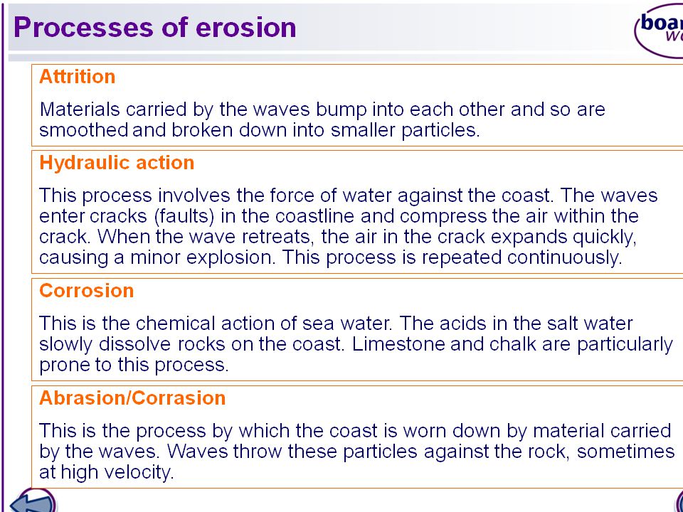
Erosional Processes We have learned that different coastlines receive differing intensities wind and wave energy. The intensity and duration can often result in varied degrees of erosion on a coastline. The can be classified into types of erosion. Wave action on coastlines causes three types of erosional process: abrasion (also know as corrosion), hydraulic action and corrosion., Cavitation is also believed to add to the pressures exerted on rock faces by breaking waves These processes are most effective when high energy waves associated with storm conditions, strike coasts made of less resistant rocks such as clay and shale.
, hydraulic action and corrosion., Cavitation is also believed to add to the pressures exerted on rock faces by breaking waves These processes are most effective when high energy waves associated with storm conditions, strike coasts made of less resistant rocks such as clay and shale.")
44
Activities Watch the animations and listen to discussion.
Complete a mind map of weathering and erosion at the coast.

45
Questions a) Explain how the different processes of marine erosion operate. b) Describe and comment upon the effects of marine processes in image A and image B. c) Discuss the factors which lead to high rates of marine erosion along a coastline. 2. a) Define ‘sub-aerial processes’. b) Outline the nature of sub-aerial processes which operate in the coastal zone in the UK.
 Describe and comment upon the effects of marine processes in image A and image B. c) Discuss the factors which lead to high rates of marine erosion along a coastline. 2. a) Define ‘sub-aerial processes’. b) Outline the nature of sub-aerial processes which operate in the coastal zone in the UK.")
47
Lesson 9 Mass Movement What are the factors affecting the rates of erosion and therefore cliff profiles along a section of coastline? What are wave cut platforms? What are wave cut notches? How do they form?

48
Mass movement Mass movement is the down slope movement of earth materials under the influence of gravity. The detachment and movement of earth materials occurs if the stress imposed is greater than the strength of the material to hold it in place.

50
Processes of mass movement
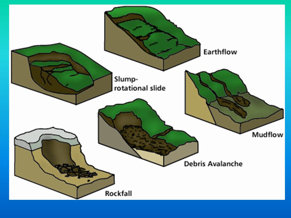
Soil creep is taking place on even the gentlest of slopes, albeit slowly. Slides occur from time to time on slopes where surface layers of grass and soil are thin. After periods of prolonged and heavy rainfall, when the ground has absorbed all the water it can take, the weight of the saturated soil becomes too great and it tears away the grass at the top of the slope. Once its hold upon the top of the slope is broke, the mass easily slides over the wet surface below, particularly where it overlies unconsolidated rocks such as boulder clay and glacial sands. Slumping is another type of mass movement that occurs in the coast zone. Slumps are distinguished from slides by the element of rotation in the flow of the mass as it moves down a curves slip plane. Many slumps are triggered off by undercutting at the base of the cliffs, so that the mass becomes unsupported. Movement by the mass is encouraged by previous saturation from heavy rains creating a well-lubricated plane of movement.

51
Coastal erosion processes create a number of significant landforms
Coastal erosion processes create a number of significant landforms. There are a number of factors which affect the rate of this erosion: i) Rock Type – A more resistant rock, such as granite, will be eroded slowly, whilst a less resistant rock, such as clay or mud, can be eroded very quickly. ii) Jointing / Faulting – The more faults and joints a rock has the more susceptible it is to erosion, both from coastal and sub-aerial processes. iii) Coastal Rock Arrangement – A coastline with rocks that run parallel to the coast is called a concordant or “Pacific” coastline. One that has rocks running at right angles to the coast is called a discordant or “Atlantic” coastline.
 Rock Type – A more resistant rock, such as granite, will be eroded slowly, whilst a less resistant rock, such as clay or mud, can be eroded very quickly. ii) Jointing / Faulting – The more faults and joints a rock has the more susceptible it is to erosion, both from coastal and sub-aerial processes. iii) Coastal Rock Arrangement – A coastline with rocks that run parallel to the coast is called a concordant or Pacific coastline. One that has rocks running at right angles to the coast is called a discordant or Atlantic coastline.")
52
Lithology (rock type) This describes the mechanical and chemical properties of rocks. Coherent rocks which have interlocking crystals, strongly cemented particles and a few lines of weakness (joints and faults), resist erosion and support steep angled slopes. Most igneous and metamorphic rocks are highly resistant. So, too, are some sedimentary rocks such as Old Red Sandstone. In contrast incoherent rocks, such as clay and sands, erode more easily. Sometimes this results in low-angles cliff profiles. However, weak rocks undercut by wave action often fail by slumping. The result may be almost vertical cliff profiles.
, resist erosion and support steep angled slopes. Most igneous and metamorphic rocks are highly resistant. So, too, are some sedimentary rocks such as Old Red Sandstone. In contrast incoherent rocks, such as clay and sands, erode more easily. Sometimes this results in low-angles cliff profiles. However, weak rocks undercut by wave action often fail by slumping. The result may be almost vertical cliff profiles.")
53
Orientation of rock types (Coastal Plan)
At a regional scale, the direction in which rocks run in relation to the coast has a strong influence on the planform of coastlines Rock outcrops which run parallel to the coastlines. Rock outcrops which run parallel to the coast often produce straight coastlines. There are known as accordant coasts. When rocks of different types crop out at right angles to the coast, the resultant planform is more varied. Here the more resistant rocks form headlands and the less resistant ones form bays. Such coastlines are called discordant.

54
Cliffs and wave-cut features
The sea cliff is the main landform along coasts where marine erosion is dominant. The basic formation of a sea cliff is the same everywhere. Waves attack the base of the newly exposed rock faces. By hydraulic action and abrasion, and the other processes of coast erosion, the base of the cliff is undercut to form a wave-cut notch. The rock face above the effects of wave action begins to overhang. As waves continue their relentless attack upon the base of the cliff, the size of the overhang increases until the weight of the rock above can no longer be supported and a section of the cliff collapses. Active marine erosion begins again at the base of the cliff after the waves have removed the loose rock, leading to further collapses and gradual retreat inland of the position of the cliff. Therefore every cliff coastline is a sign that land is being lost. As a consequence of cliff retreat another landform. The wave-cut platform, is formed.

55
Questions 1. What are the factors affecting the rates of erosion and therefore cliff profiles along a section of coastline? Mention: Rock type, jointing/faulting, coastal rock arrangement. 2. Explain the formation of sea cliffs and wave-cut notches and platforms. 3. Examine ways in which geological structure can speed up cliff collapse and retreat to form: Vertical cliffs Cliffs with variation in steepness Cliffs with low angles

56
Lesson 10 What are cliff profiles?
What affects the shape of a cliff profile? How do waves shape the headlands?

57
Landforms of coastal erosion
Cliff profiles The shape of a cliff cross-section is known as the cliff profile. Cliff profiles owe their form to the geology, sub-aerial processes and wave energy along a given stretch of coastline. Variations in profiles reflect: Rock type and resistance to erosion Presence or otherwise of lines of weakness Coastal structure Whether the cliff is active or inactive

58
Structure 1. Vertical cliffs
Few weaknesses are exposed to wave attack. The slow rate of collapse means that rock broken off in cliff collapses can be removed quickly to leave a clean face. 2. Cliffs with variations in steepness These cliffs are composed of layers of rock with different resistances to erosion. 3. Cliffs with low angles

59
Coastal plans Profile is side view, plan is map or aerial view.
Most common in the British Isles are irregular coastal plans. The irregularity is a reflection of geological structure and variations in rock resistance, which result in the formation of headlands and bays. Geological structure is the basic reason for the great number of headlands and bays around British coasts. It is predominantly discordant to coastlines so that bands of rock meet the coast at right angles. This is one of the general characteristics of coastlines which border the Atlantic ocean.

60
Wave refraction On a smaller scale some estuaries, inlets and bays provide more sheltered environments in which the average wave energy is lower than on the headlands and the more exposed coastal zones are on both sides of them. A change in coastal direction can also reduce average energy levels. Along coastlines that are irregular, waves approaching the headland feel the effects of frictional drag at their base before those which approach the bay. Waves around the headland turn inwards and concentrate their attack on them. This bending of the waves around a headland so that they approach almost parallel to the coast is called wave refraction. On the other hand, waves in the bays spread outwards and dissipate their energy. Differences in wave energy levels are thereby created at a local scale.

61
Lesson 11 How do waves shape the headlands?
Formation of caves, arches, stacks and stumps.

62
The Purbeck coast of Dorset.
The Purbeck coast of Dorset is an interesting one for geographers as it provides examples of both discordant (Atlantic) and concordant (Pacific) coastlines in one case study. Today, we will look at the discordant part of the coast and the features that are caused by this particular coastal alignment.
 and concordant (Pacific) coastlines in one case study. Today, we will look at the discordant part of the coast and the features that are caused by this particular coastal alignment.")
63
Discordant A discordant coastline is a type of coastline formed when rock types of alternating resistance run perpendicular to the shore. Discordant coastlines feature distinctive landforms because the rocks are eroded by ocean waves. The less resistant rocks erode faster, creating inlets or bays; the more resistant rocks erode more slowly, remaining as headlands or outcroppings.

64
Location

65
Old Harry

66
Attacking the headlands: Caves, arches stacks and stumps
Caves occur when the waves force their way into cracks in the cliff face. The water contains sand and other materials that help to grind away at the rock until the cracks become a cave. If the cave is formed in a headland, it may eventually break through forming an arch. The arch will gradually become bigger and bigger until it can no longer support the top of the arch. When the arch collapses, it leaves the headland on one side and a stack (a tall column of rock) on the other. The stack itself is attacked by waves from all sides. It is gradually reduced in size, forming a stump (Old Harry) and eventually it collapses so that all the signs of where the coastline used to lie disappear
 on the other. The stack itself is attacked by waves from all sides. It is gradually reduced in size, forming a stump (Old Harry) and eventually it collapses so that all the signs of where the coastline used to lie disappear.")
67
Old Harry (The Foreland or Handfast Point)
Old Harry Rocks are chalk stacks located directly east of Studland and to the north of Swanage in Dorset. The cliff is chalk, with some bands of flint, which have been gradually reduced over the centuries, some of the earlier stacks having fallen (old Harry's original wife fell in 1896), while new ones have been formed since.
, while new ones have been formed since.")
70
Dorset Coast

71
Caves, arches, stacks and stumps

72
Questions 1. From the photographs you have been given, choose one example of each of the three types of cliff profiles shown in your booklets. For each one i) draw a labelled sketch of the cliffs ii) give reasons for their form What is the most common plan form of the British Isles? Why? Explain the formation of caves arches stacks and stumps using an annotated diagram.
 draw a labelled sketch of the cliffs. ii) give reasons for their form. What is the most common plan form of the British Isles Why Explain the formation of caves arches stacks and stumps using an annotated diagram.")
73
Wave energy Coastlines with long fetches experience high wave energy. Wave energy is also higher on windward coasts than on sheltered leeward coasts. Many tropical islands which are exposed to the prevailing trade winds receive higher wave energy. On higher-energy coasts, the effect of erosion on the cliff profiles tends to be greater than the effect of sub-aerial processes. Along such coastlines, rockfalls are easily removed by wave action, allowing erosion to begin again. Low-energy coastlines have one or more of the following characteristics: a short fetch, a sheltered situation, and shallow water offshore which absorbs wave energy. In low-energy situations, sub-aerial processes may begin to dominate. Rock debris may accumulate at the cliff base, and the cliff slope angles may be lowered by weathering and mass movement.

74
Human activity Much building and recreation occurs at the coast, and this increases pressure on cliff tops, making them more liable to erosion and subsidence. The building of sea defences upsets the dynamic equilibrium of the coastline

75
Wave refraction It is very rare for waves to approach a regular uniform coastline, as most have a variety of bays, beaches and headlands. Because of these features, the depth of water around a coast varies and as a wave approaches a coast its progress is modified due to friction from the seabed, halting the motion of waves. As waves approach a coast they are refracted so that their energy is concentrated around headlands but reduced around bays. Waves then tend to approach coastline parallel to it, and their energy decreases as water depth decreases.

76
Lesson 12 A case study of a discordant coastline. (The Purbeck coast of Dorset). Features occurring along a discordant coastline.

78
Questions Draw the plan form of the Purbeck coast.
Study the OS map and draw an annotated sketch map to show the main coastal landforms. Explain the inter-relationships between geology, inland relief and coastal landforms. Study the photograph and identify map location of the features shown on the photograph, what is this called? Explain why this is a coastline of headlands and bays. Watch the video again, create a story board about the formation of Old Harry (from the location and the creation of the chalk)
")
79
Key question 4: What is the role of geology in the development of coastal landforms?
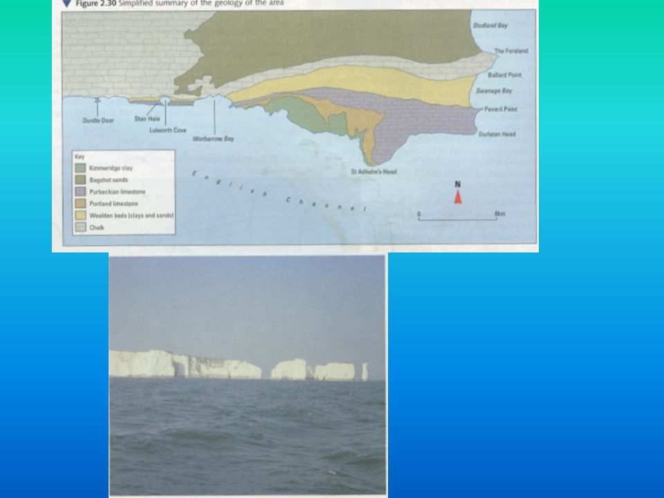
Case study: The Dorset Coast. There are relatively few examples within the British Isles where the geological structure is concordant to the coast, but the Dorset coast west of Swanage is one of them. The alignment of rock outcrops parallel to the shoreline is more typical of coasts which border the Pacific Ocean. Although many similar coastal landforms of erosion are produced, there are some differences in appearance. The study of the Dorset coast is an interesting one as it is possible to observe the stages in sequences of coastal erosion at different points along the coast which are relatively close to one another.

80
Dorset Coast

81
Concordant A concordant coastline is a coastline where bands of different rock types run parallel to the shore. These rock types are usually of alternating resistance, so the coastline forms distinctive landforms, such as coves.

82
Key question 4: What is the role of geology in the development of coastal landforms?
Case study: The Dorset Coast. There are relatively few examples within the British Isles where the geological structure is concordant to the coast, but the Dorset coast west of Swanage is one of them. The alignment of rock outcrops parallel to the shoreline is more typical of coasts which border the Pacific Ocean. Although many similar coastal landforms of erosion are produced, there are some differences in appearance. The study of the Dorset coast is an interesting one as it is possible to observe the stages in sequences of coastal erosion at different points along the coast which are relatively close to one another.

83
Dorset Coast

84
Stair Hole The early stages of a cove can be seen in that stretch of coastline near Lulworth Cove. Here, Stair Hole can be found where the limestone ridge has been breached, but not removed. Weaknesses in the ridge were exploited by waves, which opened up access to the next layer of rock which is softer. The limestone has been left exposed as a narrow ridge while the less resistant Wealden Sands and clays behind it have been more rapidly eroded. Wave erosion is now concentrated in a west to east direction following the line of the weaker Wealden beds. Inland the cliff tops are being attacked by sub aerial processes leading to gulleying and slumping in the weak sands and clays.

85
Stair Hole

86
Stair Hole & Lulworth Cove

87
Lulworth Cove This symmetrical bay is more circular and more enclosed than those typically found along discordant coastlines. This is because it has been easier for waves to extend it in a west to east direction following the line of the les resistant Wealden Beds. The gap in the limestone across the entrance is its narrowest part, while the rates of erosion on the chalk at the back of the bay are lower than those on the sands and clay at the sides.

88
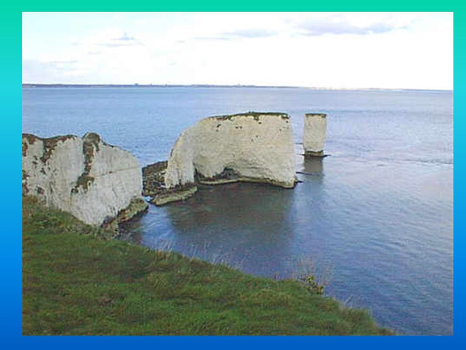
Lulworth Cove

89
Durdle Door Durdle Door is one of the most photographed landmarks along the Jurassic Coast. This rock arch in the sea was formed as a result of the softer rocks being eroded away behind the hard limestone, allowing the sea to punch through them. Eventually the arch will collapse to leave a sea stack or stump as further around the coast to the East at Handfast Point (Old Harry).
.")
90
Durdle Door

91
Concordant coastline, Dorset
What is a concordant coastline? Draw a sketch of the Dorset coastline showing Lulworth Cove, Stair Hole and Durdle Door. How were Stair Hole and Lulworth Cove formed? Draw an annotated sketch to show the process. What landform is Durdle Door an example of? What landform might it become in the future?

92
Sea level changes and coastal landforms
Worldwide climate change during the last ten thousand years has meant rising sea levels. This is the result of ice melting after the Great Ice Age has released its grip on North America, Europe and Asia. Raised Beaches (emergent coasts) Drowned Coasts (submerged coasts) Caused by pre-glacial erosion of a coastline. During the Ice Age the sea levels fall leaving the old coastline high above the present sea level. Since the end of the Ice Age sea levels have risen again, but not to their previous levels. The raised beaches continue to be above the present sea level by quite a distance. Sea Level rise after the last Ice Age caused estuaries and inlets to be flooded. This occurred in South West England, drowning many river valleys around the coasts of Devon and Cornwall, and creating Rias. In other, more northern areas, glacial valleys were drowned to create Fjords.
 Drowned Coasts (submerged coasts) Caused by pre-glacial erosion of a coastline. During the Ice Age the sea levels fall leaving the old coastline high above the present sea level. Since the end of the Ice Age sea levels have risen again, but not to their previous levels. The raised beaches continue to be above the present sea level by quite a distance. Sea Level rise after the last Ice Age caused estuaries and inlets to be flooded. This occurred in South West England, drowning many river valleys around the coasts of Devon and Cornwall, and creating Rias. In other, more northern areas, glacial valleys were drowned to create Fjords.")
93
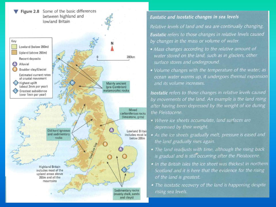
UK Sea Levels Changes in relative levels of land and sea are still occuring. Since retreat of ice sheets, the northern and western parts of the British Isles have been rising. The land has been springing back up to compensate for the removal of weight and pressure from ice masses on top. The clearest visual evidence of uplift is the flat shelf of land fringing coasts of Scotland, up to 10 m above present sea level. Known as raised beach – settlement, farming, roads/rail, golf courses. This process is called isostatic readjustment This is affecting south-east England which is tilted downwards, vulnerable to present and future SLR. This is part of natural process. Increased severity of stormy weather combined with global warming in British Isles will speed up rates of erosion, especially along east coast which is composed of geologically young sedimentary rocks. These are much less resistant to erosion than the old hard rocks which outcrop in north and western Britain.

96
Emergent coasts Emergent coasts are those that are formed when sea level declines. Areas that were once covered by the sea emerge and form part of the landscape. This new land area, which was once protected underwater, is now attacked by waves and eroded. If the new land is a cliff, waves may undercut it, eventually causing the top portions of the cliff to fall into the sea. When this happens, the beach is extended at its base. Along emergent coast shorelines the water level is quite shallow for some distance offshore.

97
Submergent coasts Submergent coasts are those that are formed when sea level rises, flooding formerly exposed land areas. Valleys near coastal areas that had been carved out by rivers become estuaries, or arms of the sea that extend inland to meet the mouth of a river. This occurred in South West England, drowning many river valleys around the coasts of Ireland, Devon and Cornwall, and creating Rias. Rias are dominant features of coastal plans of south-west England, South-west Ireland and Brittany. In other, more northern areas, glacial valleys were drowned to create Fjords e.g. Scotland.

98
Isostatic effects of ice-sheets
The formation of ice-sheets can cause the Earth's surface to sink. Conversely, isostatic post-glacial rebound is observed in areas once covered by ice-sheets which have now melted. As the ice retreats, the load on the lithosphere and asthenosphere is reduced and they rebound back towards their equilibrium levels. In this way, it is possible to find former sea-cliffs and associated wave-cut platforms hundreds of metres above present-day sea-level. The rebound movements are so slow that the uplift caused by the ending of the last Ice Age is still continuing.

99
Eustasy and relative sea level change
Eustasy is another cause of relative sea level change quite different from isostatic causes. The term "eustasy" or "eustatic" refers to changes in the amount of water in the oceans, usually due to global climatic changes. When the Earth's climate cools, a greater proportion of the earths water is stored on land masses in the form of Glaciers, snow, etc. This results in a relative fall in global sea levels (relative to a stable land mass). The refilling of ocean basins by glacier meltwater at the end of ice ages is an example of eustatic sea level rise. A second significant cause of eustatic sea level rise is thermal expansion of sea water, when the Earth's mean temperature increases.
. The refilling of ocean basins by glacier meltwater at the end of ice ages is an example of eustatic sea level rise. A second significant cause of eustatic sea level rise is thermal expansion of sea water, when the Earth s mean temperature increases.")
100
Raised beaches show that sea level has changed
A raised beach is an elevated area of sloping ground, sitting above the present tide line. In the past this area was at sea level. There are many examples of this feature throughout Britain, particularly along the West coast - this is because the area experienced the greatest weight of ice during the last Ice Age (about 10,000 years ago). During an Ice Age, the massive weight of ice bearing down on a landmass caused it to sink. Over time, as the earth's temperature rose and the weight of ice decreased, areas of land began to slowly rise back out of the sea. This ‘bounce back' motion - the localised change in sea level, relative to the land - is known as isostasy, or isostatic uplift. Some raised beaches may consist of several different levels, each indicating a different stage in the shoreline's development. The town of Stonehaven has been built on an area of raised beach, at three different levels.
. During an Ice Age, the massive weight of ice bearing down on a landmass caused it to sink. Over time, as the earth s temperature rose and the weight of ice decreased, areas of land began to slowly rise back out of the sea. This ‘bounce back motion - the localised change in sea level, relative to the land - is known as isostasy, or isostatic uplift. Some raised beaches may consist of several different levels, each indicating a different stage in the shoreline s development. The town of Stonehaven has been built on an area of raised beach, at three different levels.")
101
Activities Annotate your geological map of UK to show differences in rock types and land heights. Define Isostatic and Eustatic changes in sea levels. Describe the formation of drowned coasts (submergent) and raised beaches (emergent). What are Rias?
 and raised beaches (emergent). What are Rias")
102
Key question 3: What are the processes of marine transport and deposition and what are the resultant landforms? Transport and deposition in the coastal zone Sources of beach sediments Beaches are an accumulation of sand and shingle deposited by waves in the shore zone. The sediments which form beaches enter the coastal system through rivers, cliff erosion and wave transport. Rivers account for around 90% of beach sediments. Sand and shingle transported as bedload enter the coastal system through river mouths. Although cliff erosion is very active on some coastlines, it provides less than 5% of all beach sediments.

103
Landform 1: The beach The beach is the zone of deposition between high and low tidal limits, which shelves downwards towards the sea. The lower beach is characterised by a gentle gradient, because it is most likely to be built of fine grain sand and mud. Minor features include ripples, ridges and runnels. The upper beach can usually be distinguished by its steeper profile which reflects its composition of coarser sediments such as shingle and pebbles. Ridges form in the shingle and maintain their position longer than minor features in the sandy part. Highest of all is the storm ridge. Below at different levels are beach ridges called berms. Where the shingle and sand parts meet, beach cusps sometimes protrude down the beach. What do you think determines the type of material on a beach?

104
Beach profiles.

105
Beach profiles Beach profiles change in summer and winter in the British Isles. The summer beach is wider and has more generous cover of sand and shingle. Storm waves are less frequent which gives more time for constructive waves to re-nourish the beach. In winter, deposits which form the lower beach are more vulnerable to removal by destructive waves, although the area above the inter-tidal zone can be attacked under storm conditions. This area of summer deposition and winter removal is known as the sweep zone. One big winter storm can have a tremendous impact.

106
Lesson aims: How are bars formed? How are tombolos formed?

107
Landform 3: Bars These form in the same way as a spit initially but bars are created where a spit grows across a bay, joining two headlands. Behind the bar, a lagoon is created, where water has been trapped and the lagoon may gradually be infilled as a salt marsh develops due to it being a low energy zone, which encourages deposition. An example of a sand bar is Slapton Sands in Devon.

108
Spits and bars Favourable conditions for growth:
Bend or change in direction of the coastline Plentiful load Active longshore drift Environments favouring constructive waves. Low energy zones Factors for reducing or stopping growth: Reduction in the supply of sand and shingle Deeper water Stronger river and tidal currents More exposure to storm waves.

109
Landform 4: Tombolos A tombolo is a deposition landform such as a spit or bar which forms a narrow piece of land between an island or offshore rock and a mainland shore, or between two islands or offshore rocks. They usually form because the island causes wave refraction, depositing sand and shingle moved by longshore drift in each direction around the island where the waves meet. An example is Chesil Beach in Dorset.

110
Questions Describe and explain the formation of bars.
Describe and explain the formation of tombolos.

111
Landform 2: Spits - A long, narrow ridge of sand attached at one end to the coast. - Built up by long shore drift transporting material along the coast. - At a bend or break (for an estuary) in the coastline the material being carried is dropped. However it is deposited away from the coastline. - As the spit builds out to sea the end is affected more by the wind and by wave currents, causing the end to curve towards the shore, to create a hook end. - Material often accumulates in the area of standing water that occurs behind a spit, and this can lead to the formation of salt marshes. - Spits can be areas where large sand dunes build up, nearer the back of it. An example is Spurn Head, Humberside.
 in the coastline the material being carried is dropped. However it is deposited away from the coastline. - As the spit builds out to sea the end is affected more by the wind and by wave currents, causing the end to curve towards the shore, to create a hook end. - Material often accumulates in the area of standing water that occurs behind a spit, and this can lead to the formation of salt marshes. - Spits can be areas where large sand dunes build up, nearer the back of it. An example is Spurn Head, Humberside.")
112
Questions 1. How are beaches formed?
2. Explain why beach profiles vary between summer and winter. 2. How are spits formed? 3. For a named example draw an annotated diagram of spit formation.

113
Landform 5: Sand dunes Sand dunes are small ridges or hills of sand found at the top of a beach, above the usual maximum reach of the waves. They form from wind blown sand that is initially deposited against an obstruction such as a bush, driftwood or rock. As more sand particles are deposited the dunes grow in size, forming rows at right angles to the prevailing wind direction. If vegetation, such as Marram Grass and Sand Couch, begins to grow on the dune its roots will help to bind the sand together and stabilise the dunes. An example in Wales is Kenfig Dunes which is a S.S.S.I.

Similar presentations